In modern society, the desire to purchase land increases every year. The main purpose of acquiring a plot of land is to build a country house for permanent residence, sometimes for farming or forming a family estate for one’s family. In any case, there is a need to discover vacant lands and plots that will not be difficult to acquire.
How did you search for a free plot of land?
On the Rosreestr website I found and opened a public cadastral map.
At the same time, in separate browser tabs, I opened (since 2018 the service has temporarily not provided such a service) the satellite map of Google and Yandex.
Having previously studied the Land Use and Development Rules, as well as the Urban Zoning Map, I chose an area that I liked and in which individual housing construction is allowed.
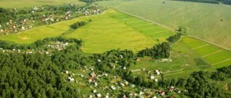
This is what the area looked like on the Urban Zoning Map.
Next, I found the selected area on 3 tabs:
- on the online service,
- on the public cadastral map,
- and on Google satellite map.
It was more convenient for me to start looking for a plot of land (since 2018, the service has temporarily not provided such a service), since the map of the online service contains not only the boundaries of cadastral blocks and land plots, but also the names of streets, objects (for example, a school, stadium, kindergarten, store, etc.).
This simplified the search and minimized the risk of errors.
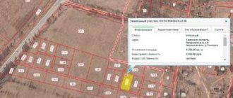
This is what the map of the online service looks like, on which, in addition to the boundaries of the land plot, street names and names of objects are visible.
The public cadastral map, unlike the online service map, does not contain street names and infrastructure facilities, so it can be difficult to correlate the area selected on the Urban Zoning Map with the public cadastral map.
This is what the same area looks like on the public cadastral map of Rosreestr. There are no landmarks other than the boundaries of the land plots.
Next, having studied the selected area on all these maps, I found and wrote down the numbers of cadastral blocks, on which free spaces for the formation of a land plot were visually clearly identified.
After several cadastral blocks were found on the map of the online service and on the public cadastral map, where vacant plots were visible, it was necessary to check whether these conditionally vacant lands were occupied by any buildings or structures, etc.
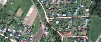
To do this, I found vacant lands on Google’s satellite map and looked at what was on them. Some territories were no longer needed because some structures were located on them.
And one plot of land was visually free.
I was not too lazy to go and inspect this area.
There were trees and bushes growing on it, there were no buildings, or at least no surviving buildings were observed.
Since the area I had chosen had been built up with houses since Soviet times, I suspected that on the site I had chosen there had once been some kind of hut, which was completely dismantled.
However, I decided to prepare a diagram of this land plot and submit an application for preliminary approval of the provision of the plot.
I showed the entire process of searching for a plot of land in the video.
article
Step-by-step instruction
Basic moments
The Rosreestr website provides a lot of information online. There is a convenient information resource that makes it possible to obtain data on land plots in the form of a certificate. The service has been operating since 2010 and is posted on the Rosreestr website.
The service contains a graphical representation of areas located throughout the country. The government has limited the list of data that can be obtained using the card. Personal information and information constituting state secrets must not be disclosed. The rule is determined by Government Decree No. 467 of May 20, 2014.
You can find out how much an object costs. There is data on buildings, land plots and unfinished objects.
Step-by-step scheme for obtaining land for building a house.
Initially, I “pumped” the local administration’s website to search for already formed land plots, which the administration puts up for auction for the purpose of sale or lease.
Not many plots were offered.
But what struck me most was the cost.
The administration put almost all the plots up for auction at cadastral value.
In my opinion, this is outright “robbery”, since, as many people know, the cadastral value, as a rule, is many times higher than the market value.
This state of affairs convinced me of the wisdom of the idea of following the path described in the instructions: “How to get land” and applying for a plot of land that has not yet been formed.
The first thing to do was to find free land.
Infrastructure
It is worth paying attention to whether problems will arise when connecting to electricity, gas and water supply. An important factor for comfortable housing is the presence of a road next to the site, close to it:
- store;
- pharmacies;
- sports ground;
- kindergarten and school.
What is it for
An independent search for a free plot of land is usually initiated by a citizen in a certain situation when the information from the local administration does not suit him on some issues.
For example, having received from the administration a cadastral map of the territory of interest and having become familiar with it, a citizen did not find an area of interest to him.
One of the reasons for independently searching for free land for individual housing construction is the high cost of the plot being sold or leased to the local administration.
An independent search for land will provide a person with much more freedom in obtaining the desired result.
This is especially convenient when a person needs a site that meets certain requirements: area, configuration, location (forest, river, etc.), availability of production, transport and social infrastructure.
By marking the boundaries of the future site on the cadastral map, the user immediately receives information about its area, perimeter length, and coordinates.
After this, a screenshot of this part of the cadastral map with the generated plot of land is taken, which is subsequently provided to the Administration to decide on the acquisition of this plot as ownership or lease to the applicant.
What can you find out about the site?
You can find out different information:
- cadastre number,
- land status,
- price of land
- type of permitted use,
- date of last information update,
- date of registration,
- land area.
The service will also help you find out information about zoning. It is specified how the allotment can be used. It’s convenient that you can get an answer at any time. In addition, there is information about buildings that are built on the ground.
So, to get information, you need to go to the Rosreestr website, then to the cadastral map and enter the number of interest. If it is unknown, the search can be carried out by location.
Purchase of state land into ownership.
According to the law (clause 6, clause 2, article 39.3 of the Land Code of the Russian Federation), the owner of a building or structure has the right to acquire ownership of the land plot on which the real estate is located without bidding.
In other words, if you built a house yourself or bought a house on a plot that is leased, then you can buy the plot without bidding.
Using this opportunity can be especially beneficial in relation to plots for individual housing construction.
This method is also applicable to plots for private plots within the boundaries of a populated area, because the construction of individual residential buildings is allowed on such plots.
Further in the text only individual housing construction will be mentioned, but it should be understood that this method is also applicable for private household plot land within the boundaries of a populated area.
Note.
For plots of private household plots located outside populated areas (field plots), the purchase of land using this method, as a rule, is not applicable, because it is impossible to build an individual residential building on a field plot.
Public cadastral map of the Russian Federation as of July 26, 2020
The public cadastral map of Russia is a resource that provides permanent access to reference information on real estate, updated in 2021. The map graphically shows land plots and capital construction projects that have undergone the cadastral registration procedure during land surveying and are included in the Unified State Register of Real Estate.
For each region of the Russian Federation, you can clarify the number of registered real estate objects as of the current date. Information is presented by type of property.
To view the plan of a registered plot and find out publicly available information on it, you need to enter its cadastral number, location address or click on the official map and the data will open for you: cadastral number, purpose, registered area, for the house, year of construction, location coordinates. By navigating a cadastral map from a satellite, you can evaluate the infrastructure surrounding the land plot, adjacent lands and objects.
Below the map there is a list of regions by which you can narrow your search. When you select the desired area, the territory will be zoomed in on the map.
To expand the list of information received about a land plot or building, here you can also order an extract from the Unified State Register of Real Estate about the property or the history of the transfer of rights, as well as a certificate of cadastral value.
In cases when calculating tax or division of property, real estate transactions, inheritance or registration of a mortgage, it is required to know or obtain a certificate of cadastral value. We will tell you in more detail how to find out in this article.
- When searching by cadastral number of a plot of land, you will need to enter it in the search line. Brief information about the land category will appear.
- For more detailed results, click on the cadastral number. Where information about the category of land and types of its use will be reflected.
Using the cadastral map, you can find a vacant plot in the area of interest. To do this, you need to follow several steps:
- Select the search area for the land plot.
- On the right on the map. In the drop-down list, select “Form of ownership of the plots.”
- After selection, all plots of land will take on a colored color:
- pink - private property;
- purple – property of public legal entities.
Uncolored areas on the public map are free.
Establishment of the exact boundaries of a land plot occurs on the basis of land surveying. Situations often arise that require clarification, and this issue can be resolved with the help of a public cadastral map. You can find out the coordinates in the following order:
- Find your plot of land on the map.
- Among other data, the coordinates of the site are displayed (to do this, click on the “Details” button at the bottom of the window).
The location of the allotment must be looked at on the map when, for example, you plan to purchase it. Then you are interested in the infrastructure closest to it, the shape of the site, and its location relative to other objects. You can do this using the following instructions:
- Find a plot of land by entering its cadastral number in the search bar.
- Using the navigation buttons in the upper left part of the map, you can move the object a little further and view its position relative to the surrounding area.
- You can see in which zone the site is located by following the diagram, select on the left: Thematic map → Zones with special conditions for the use of the territory.
Read detailed instructions here.
There is a convenient service that will help you quickly find a cadastral number at an address - FIND.
Still have questions? Look in the "Reference Information" section.
How to find vacant land
If you are interested in vacant land, you can select a plot on the cadastral map.
The data will be prepared after clicking on the “. You can also familiarize yourself with the information provided from the Unified State Register of Real Estate.
If the number is unknown, then land plots can be searched by address. For example, they are interested in vacant plots in Moscow. Moscow is indicated, and then a list of addresses will be displayed.
Nuances of providing information
Public cadastral map is a server that contains information for free access. In some cases, an electronic digital signature may be required. Instructions on how to use it correctly are contained in Law No. 63 of 04/06/2011.
Procedure
Land surveying consists of several stages. First, the customer and the contractor enter into an agreement. It is preceded by the owner’s choice of a reliable organization of cadastral engineers.
See more details here.
Documentation
The responsibilities of a cadastral engineer include not only geodetic work, but also document processing. He lists to the owner what documents are needed to determine the boundaries.
You must submit copies of the following documents
- identification;
- document on registration of property rights (Certificate or extract);
- title document;
- previous survey (if any);
- court decision (if boundaries are disputed).
During the land surveying procedure, other documents may be required.
Coordination of boundaries with neighbors
Coordination with neighbors is a very important stage in land surveying. If you approach this issue wisely, you can quickly go through all stages of land surveying. Otherwise, because of 10-20 cm, you can spend a long time sorting it out, spending time and money on legal and court costs. So first you need to decide what exactly you need.
When relations with neighbors are friendly, the issue of boundaries must be resolved through negotiations. That is, first agree, and then invite them with their passports to sign the agreement document, which is prepared by the cadastral engineer. Thus, all necessary formalities will be observed.
If the plots in the neighborhood are abandoned, then you need to find out from the SNT board or the cadastral chamber who the neighbors are on the plots adjacent to yours. Sometimes this work is undertaken by a cadastral engineer.
A notice of the upcoming arrival of a cadastral engineer must be sent to the indicated addresses. He must explain where the border will be and offer to sign the document.
It is better not to sign the approval act without an explanation from the cadastral engineer. Most often, the owner of a neighboring plot does not understand what data he is signing. When signing the approval act, the following must be present: the cadastral engineer, the land survey customer and the neighbors on the site.
Drawing up a boundary plan
The cadastral engineer prepares the main document based on the results of the work - the boundary plan. It consists of 2 parts (text and graphic) and contains a detailed report on the measurements and coordinates of the site boundaries.
The boundary plan is submitted in 2 copies. One remains with the owner of the plot, the other is sent to the cadastral chamber to make data or changes.
Registration and payment of state fees
in electronic or paper form
The electronic version must necessarily contain the electronic signature of the cadastral engineer.
On paper, there must be a signature and seal.
The owner can independently submit the boundary plan to Rosreestr. It is more convenient to do this through the MFC.
To do this, you only need a passport and a boundary plan. Payment of state duty when entering data into the state cadastre is not provided.
The contracting company whose representative draws up the boundary plan for you may charge an additional fee for submitting documents. This will be payment for intermediary services, but not state duty.
The actual location of the site and that indicated on the public cadastral map must match
In an even more difficult situation, those whose plots, when changing the coordinate system used to maintain the Unified State Register (formerly the State Register of National Registers), find themselves, according to register data, far from their actual location - sometimes in another area, at the site of a water body, etc. . The change of coordinate system occurred in our country twice. As a result, many land plots “moved out”, although their boundaries when registering for cadastral registration were determined based on the results of land surveying. The legal status of such areas is not defined by law, and the algorithm of behavior in this case is not regulated.
Such a change in the location of a site is easy to see on a public cadastral map. If it is detected, you should contact Rosreestr with an application to correct the technical error. As a rule, Rosreestr does this, but only if the rights of third parties are not affected. Otherwise, as stated in Part 4 of Art. 61 of the Law “On State Registration of Real Estate”, the error is corrected by court decision (although changing the coordinate system can hardly be called an error). Here you will have to order a land survey examination and identify errors made in determining the boundaries. This process can drag on for many years.
How to use the site
The question of how to find a vacant plot of land online on a public cadastral map will not be difficult to solve if you have an idea about using the service.
3 nuances of working with the site:
- in order to move around the image, you need to hold down the left mouse button and move the map,
- you can change the image scale using the “+” and “-” signs,
- It is possible to clarify the distance on the map and the area of the object.
All nuances are displayed in a separate information window. You can view general information on the website. If you need details, you should order a cadastral extract by going to the “Services” section.
Why is it beneficial to get video instructions now?
- because you deserve to receive a plot of land without bribes and hassle.
- By following simple steps, you get a piece of land that belongs to you by birthright,
- because you can receive free advice and help from me. Enough in the comments, I will definitely respond and help with advice.
Using step-by-step instructions, I am searching for land plots from Khabarovsk to Anapa.
I willingly share my experience with everyone. But the most valuable information is received by those who purchased step-by-step video instructions.
because after receiving land for building a house, you will need to submit a notification of the plan.
Starting construction on a plot of land without notice is like shining a match in a gasoline tank.
Warm, light, bright, but not for long. Because unauthorized buildings are bulldozed without any ceremony.
because, get a BONUS - a free book by the founder of the University of the Evolution of Consciousness: “Energy Meditation: Cracking the Human Code” by Alexey Deryabin.
Any change in life circumstances, including such as receiving land, is preceded by an internal change.
Alexey, as a practicing expert, knows a short way to achieving the desired goal. His experience and practical skills will help you realize your aspirations and innermost dreams.
I wish you a decent life
Size and shape
It is difficult to build on long and narrow plots of land. Therefore, when buying land, it is better to pay attention to advertisements for the sale of plots of the correct shape: square or at least rectangular.
Square
You should pay special attention to this. Therefore, before buying a territory, think about what you plan to place on it. It is necessary to take into account not only the size and layout of the future home, but also the possible presence of outbuildings.
For example, to develop a complete suburban complex you will need at least 1000 square meters. For a more modest household, 700 square meters is enough. m., for a small one you will need about 400 sq. m. It is worth calculating whether the buildings will comply with sanitary standards, and outline the routes of cables and pipelines.
There must be a certain distance between buildings. In particular, to sheds with an area of less than 50 square meters. m. - at least 15 meters, as well as to the toilet with a trash can. The distance to the garage is at least 10 meters. A certain number of meters must separate the house from the roadway and neighboring buildings. The same rule applies when planting trees and shrubs.
When choosing a territory, you can discuss zoning features with the architect. It is believed that the use should include a front area (entrance and front porch), a garden plot, a recreation area, a playground, a parking lot, and an area for household appliances.
A specialist will not only help you arrange them correctly and conveniently, but will also tell you whether this plot of land will be enough to build a house with all the additional structures. If you don’t understand this yourself, then there is a risk of visually overestimating the area, which will lead to a lack of space in the future.
How and where to find out by number
To accurately find out the category of land, you need to order an extract from the Unified State Register of Real Estate. Since 2021, this database combines both technical information about real estate objects and information about the rights to them.
order in several ways
- in person at the office of Rosreestr or MFC;
- by mail;
- through the Internet.
You can obtain the document:
- in the territorial office;
- by mail (it will be sent to the specified address);
- or by email (this option is only possible when applying via the Internet).
Each method has its own advantages.
- When contacting the Rosreestr branch, you can point out minor flaws in the application so that they can be corrected immediately. There are often samples available locally.
- MFC offices usually have more convenient work hours.
- Postal mail is suitable for those who live far from the divisions of these organizations.
- And the Internet allows you to send an application at any time of the day and without leaving your home.
Therefore, everyone can choose the option that suits them best.
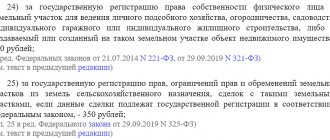
The cost for individuals is 300 rubles. You can pay the state fee at any bank branch. The receipt must be attached to the application.
An extract can be received 3 business days after the application is accepted. If you use the services of the MFC, the period increases to 5 days.
When receiving at your home address, the time required for delivery of the letter is added.
Let's take a closer look at how exactly to send a request for an extract in various ways.
Personal appeal
You can order an extract at any branch of Rosreestr. It is not necessary to choose the one to which the property belongs. You can find out the address of the selected branch and its opening hours on the website. There you can make an appointment at a certain time if you don’t want to wait in line on the spot.
As a rule, forms and samples are available in offices. But you can:
- from the site,
- fill it out in advance
- bring with you.
You can fill it out on a computer or by hand in legible handwriting. The application must be signed. The date of its submission is indicated (even if filled out in advance).
You will need:
- passport,
- documents confirming land ownership.
If it is not the owner himself who is applying, you will have to issue a power of attorney from a notary.
A parent or guardian may act on behalf of a minor child. In this case, you will need a birth or adoption certificate.
All documents must be copied. They are attached to the application.
MFC
Submitting an application through the MFC office is the same. But you will have to wait longer, since additional time is required to transmit the request.
To make an appointment in advance you need:
- Go to the “Pre-appointment” section.
- Among .
- And indicate the desired territorial location of the office.
- Then choose a department and free time.
Ordered letter
The address of territorial offices can also be found on the Rosreestr website.
Enclosed in the letter:
- statement,
- copies of the necessary documents.
Since the originals cannot be shown, copies will have to be certified by a notary.
An inventory of the investment is also prepared.