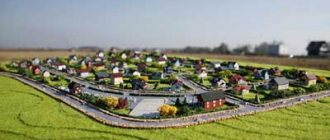
The public cadastral map is in the public domain. This is a map that contains data on real estate objects - land plots, houses and other buildings and structures. Is it possible to find out the coordinates of a cadastral plot on a public cadastral map? Yes, you can. But what will be the accuracy of these coordinates, in what system they will be presented, how they can be obtained and where the coordinates of the land plot can be used will be analyzed in more detail.
Public cadastral map data
If we open a public cadastral map, or as it is called in professional slang “public”, we can find out a lot of interesting things about the property: cadastral number, cadastral value, address, type of permitted use of the site, purpose of the property (residential building, non-residential building) and much more.
But the public cadastral map does not contain all the information in the public domain. For example, information about the owner and coordinates of characteristic points of the boundaries of a land plot can only be obtained from an extract from the Unified State Register of Real Estate (USRN).
Building coordinates
The most reliable and accurate measurement methods are the geodetic method, as well as the method of satellite geodetic measurements. When using them, high-tech modern measuring instruments are used, and points of the state geodetic network are used as starting points for determining coordinates.
Expert commentary . After carrying out cadastral work and preparing a technical plan, the content of this document includes not only information about the selected research methods, but also an indicator of measurement accuracy (error).
What can information on the cadastral numbers of a plot give?
If you know the cadastral number of the desired object, then it is possible to obtain the following information from it:
- Territorial number of the district, territory, quarter and affiliation with the Rosreestr body of your land plot.
- Characteristics of the status of the land plot.
- The actual location of the site.
- Total area.
- Cadastral value of land.
- Date of registration, with information about updating data by date.
- Category of land plot.
- Type of permitted land use.
Polygon: Boundary plan
A computer program for automating the preparation of a boundary plan - documents and drawings for registration of land plots with the state cadastral register and for recording changes in land plots with the generation of both printed and electronic XML files, a zip archive for delivery (digital signature is not required), sending to Rosreestr.
“Polygon: Boundary plan” – a program for automating the design of a boundary plan
– documents and drawings for registering land plots for cadastral registration and for accounting for changes in land plots, as well as preparing a diagram of the location of a land plot on the KPT with the formation of both printed and electronic documents, creating a ZIP archive, signing electronic signature files and sending boundary plans to Rosreestr.
How to find out the coordinates of the site?
Often the citizen is only informed of the cadastral number of the land plot. To find out the coordinates of the boundaries of a land plot or the size of the plot by coordinates, you need to go to the website of the public cadastral map. It has a number of tools:
- Search for objects
- Objects at a point
- Card management
- Drawing
- Measurements
- Favorites
- Print map
- Background information
- Feedback
Using them, you can find out various data about the site. Such as GPS coordinates of the site, length of the site by coordinates and many others.
What do X and Y Coordinates Mean in a Land Survey Plan?
If we selected Specify land plots and their parts, a dialog box appears asking for the recorded plots adjacent to our plot. When specifying the table of land plots in the Approval Certificate, a list of adjacent subcontractors is compiled. The requested table must have a required field Cadastral_number .
The program generates outlines of the nodal points of the area selected on the map. We select the area(s) we need and launch the menu item Boundary plan/Outline. Set the working folder for the outline. Next, we determine whether to show the outline at all nodes of the section or not. If not all, then we list, separated by commas, all the node numbers of the section that we do not need. As a result, a report with outlines of points is generated.
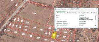
How to find the coordinates of a property on a public map
There is one little trick on the public cadastral map - when we move the cursor (mouse) over any point, the geographic coordinate of this point is displayed in the search window. Thus, by hovering the mouse over the corner of the plot we need, reflected on the cadastral map, we can find out what its geographical coordinates are. We carry out all these manipulations with all other points, the main thing is not to forget to maximize the scale of the map. Also, on the cadastral map there is such an option (tab in the form of a ruler), which allows you to measure the distance from one point of the site to another and calculate its area.
Land survey plan
The purpose of the course project is to understand how land management is formed. CHAPTER 1. BASES AND PURPOSE OF THE WORK The delineation of land management objects is carried out on the basis and in accordance with the assignment for the work. The task is prepared by the customer or, on his behalf, the work performer (contractor) on the basis of the territorial land management project and/or information from the state land cadastre about the land plot (plots), provided in the form of extracts in the form of a cadastral map (plan) of the land plot (territory). The task is approved by the customer and agreed upon by the contractor.
Erasures, additions, crossed out words, and other corrections on the map (plan) of the land management object (map (plan) of the boundaries of the land management object) are not allowed. A map (plan) of the boundaries of a land management object (map (plan) of the boundaries of a land management object) cannot be drawn in pencil.
Why can I use plot coordinates from a public cadastral map?
Why can we use the given coordinates of the site, the distance from point to point and its area?
We can use all the information obtained in such an approximate way only for personal purposes, because the accuracy of the coordinates that we learned in this way leaves much to be desired. Even when we have increased the scale of the map as much as possible, the error may be plus or minus a few meters.
If you only have the cadastral number of a land plot, you can easily find it on a public cadastral map and understand where it is located.
You can roughly calculate its area and perimeter. Also, by copying the coordinates into Yandex or Google maps, you will see what the site looks like from a satellite.
Specialists in the field of geodesy and cadastre often use the geographic coordinates of a land plot as navigation (for example, if you need to go to an area and measure a site that does not have an address).
To prepare official documentation, site coordinates taken from a public cadastral map CANNOT be used.
Coordinates from a public cadastral map are quite suitable for finding out the approximate location of a site. For example, a potential buyer, if he wants to purchase land as a property, can use the cadastral number of the plot to find out what its approximate parameters are.
Independent search
It is possible to independently search for the boundaries of the site. To do this, you need to have knowledge of mapping and understand the workings of the cadastral system. If the owner is able to take into account everything necessary, he can independently establish the perimeter.
It will not be possible to use the results of independent surveying to make changes to the Rosreestr database. This information can only be learned if the work was carried out by a qualified professional with a valid license.
Boundary determination procedure
The cadastral map with coordinates is drawn up taking into account the established and approved rules. To obtain the most accurate results, follow the procedures detailed below.
Preparatory stage
All necessary documentation is prepared. The absence of even one document may result in a boundary determination request being denied. All collected papers are submitted to the branch of the organization that carries out geodetic work.
The package includes the following titles:
- identification;
- title papers;
- technical documentation for the land;
- cadastral passport (if available).
Land surveying services are provided on the basis of an agreement concluded between the owner and the organization. The agreement is drawn up according to a standard plan. When the agreement is drawn up, a date and time for the work is set. Representatives of all interested parties must be present during their implementation.
Geodetic works
Land surveying is carried out by carrying out geodetic work. The essence of the process is as follows:
- the perimeter of the sides of the site is measured;
- designations are established;
- all received data is documented;
- the consent of all interested parties is also noted.
Transfer of data to Rosreestr
Having completed all land surveying work, the engineer transmits the data to Rosreestr. The documentation is sent to the territorial department in charge of the required land plot.
Consideration of the survey results is the final stage of establishing the boundaries of the plot and assigning individual identification information to it.
Accuracy and error
Taking into account the characteristics of the area and the qualifications of the cadastral engineer, errors may be made during land surveying. Since errors cannot be avoided, the law sets a certain limit on inaccuracy. Exceeding this parameter causes a revision of all data.
The parameters of permissible errors depend on the type of site, its location and purpose:
- land within a populated area from 5 to 10 cm;
- land for dacha cooperatives and agricultural purposes - up to 20 cm;
- agricultural land - up to 2.5 m;
- land withdrawn from circulation – up to 5 m.
Coordinates of site points in geographic and local systems, what is the difference?
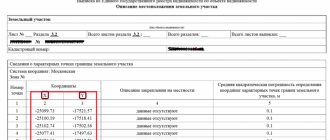
The coordinates that we see in public by hovering the cursor over a point are presented in the generally accepted geographical system. And the coordinates that we see in the USRN extract are displayed in the officially accepted local coordinate system.
Each coordinate system has its own practical application, both on a global and regional scale. In some specific cases it is possible to use local and conventional coordinate systems, and in some cases other specific geographic systems are used.
Thus, in order to submit a boundary plan for registration with Rosreestr, it is customary to indicate the coordinates of the site in the local system, and in order to prepare a topographic plan for the Federal Air Transport Agency or Rosnedra, they indicate the coordinate points of the land plot in a certain geographical system (for example, in PZ-90.02/90.11 , WGS84). Even if we want to do without the USRN extract, and use the numerous free or paid services for recalculating coordinates that are offered to us on the Internet, we still will not achieve even the slightest accuracy. Therefore these actions are useless.
Thus, it will not be possible to find out the exact coordinates of a land plot using data from a public cadastral map, without ordering an extract. In order to establish the exact area and parameters of the site, you should order the removal of the site boundaries in kind using the official local coordinates indicated in the Unified State Register of Real Estate extract.
T TOP-15 questions on the boundary plan
The tables must indicate the coordinates of characteristic points of land plots, parts, and contours. And also the column “Root mean square error of the position of the characteristic point (Mt), m” must be filled in, since these values are used in the calculation.
An application under the Requests_GKN_Realty scheme versions 17 and 18 is only necessary to send additional packages of documents to Rosreestr through direct interaction channels. In other cases, we recommend using a statement according to the StatementGKN version 01 .
Extract from the Unified State Register of Real Estate – information about the coordinates of the land plot
As for the question of how to find out the coordinates of a plot on a public cadastral map, the simplest answer is to order an extract from the Unified State Register of Real Estate, if the land plot has undergone a survey procedure, then the section of the extract “Description of the location of the land plot” will contain information about the coordinates of the points of the boundaries of the land plot in local coordinate system.
Having in hand the data from the EGRN extract, you can easily and accurately determine the coordinates on the ground - to do this, you just need to order the removal of the boundaries of the site in kind. However, all these activities require financial costs. The cost of the USRN extract is from 250 to 1000 rubles, depending on where to order it and what version (paper or electronic). The cost of removing the boundaries of a land plot in nature is also an individual procedure. (You can find out who carries out boundary removal in your region using a convenient and free online catalog of geodetic works, and at what prices - using a cadastral work calculator).
Before the introduction of the Land Code (hereinafter referred to as the Land Code of the Russian Federation), decisions on the provision of land plots were often made without carrying out land surveying and cadastral registration. Accordingly, a huge number of land plots to this day do not have precise boundaries.
But without them there is no land plot itself, since it is the boundaries in accordance with clause 3, part 1, art. 7 of the Federal Law of July 24, 2007 No. 221-FZ “On the State Real Estate Cadastre” (hereinafter referred to as Law No. 221-FZ) individualizes it as a thing. Due to imperfect legislation, land disputes in the event of disagreements with the owners of neighboring plots are very complex. What risks accompany registration of rights to a land plot? How to avoid unnecessary complications when registering a plot of land for cadastral registration?
Establishing the boundaries of a land plot.
Before moving on to a description of the mechanism for resolving a legal dispute, it is necessary to dwell on the rules for conducting cadastral work to clarify the boundaries of land plots.
In accordance with Art. 11.1 of the Land Code of the Russian Federation, a land plot is recognized as a part of the earth’s surface, the boundaries of which are determined in accordance with federal laws. Thus, the most important elements of a land plot, individualizing it among the objects of civil rights, are boundaries. The boundaries of a land plot are determined in accordance with Law No. 221-FZ, and information about them is entered into the state real estate cadastre, which is primarily a systematized set of information about real estate registered in the manner prescribed by law.
The state real estate cadastre includes, among others, such unique characteristics of a site as a description of the location of its boundaries and its area (clause 3, 6, part 1, article 7 of Law No. 221-FZ). According to paragraphs 7, 9 of Art. 38 of Law No. 221-FZ, the location of the boundaries of a land plot is established by determining the coordinates of their characteristic points.
When clarifying the boundaries of a land plot, their location is determined based on the data available in the document confirming the right to the land plot, and in the absence of such a document, from the information contained in the documents that determined the location of the boundaries of the land plot when it was formed (technical passport, contracts, certificates ).
Please note: in the absence of documents, the boundaries of a land plot are recognized as boundaries that have existed on the ground for 15 years or more and are fixed using natural objects or objects of artificial origin that make it possible to determine the location of the boundaries of the land plot.
Disputes most often arise and have the greatest difficulty when clarifying the boundaries of land plots, since it is often impossible to determine the coordinates of characteristic points using title documents. The legislator took into account possible abuses in this area and introduced a procedure for mandatory coordination of the location of borders with the legal holders of adjacent land plots.
The procedure for agreeing on the location of borders.
The procedure for agreeing on the location of borders is quite clearly defined in Art. 39 and 40 of Law No. 221-FZ and is mandatory when carrying out cadastral work to clarify the boundaries of a land plot.
In general, the approval procedure can be divided into three stages.
Stage I. Preparatory.
As part of this stage, it is necessary to carry out the following actions:
1. identify all interested parties (Part 3 of Article 39 of Law No. 221-FZ states that these are owners of land plots, persons who own land plots under the right of lifelong inheritable possession, permanent (perpetual) use and lease). It should be noted that the Law provides for certain exceptions from this list. Interested parties can be identified by requesting information from the state real estate cadastre (they are open), although in most cases all interested parties are known;
2. determine how the location of the site boundaries will be coordinated. The law gives the customer of cadastral work, who, as a rule, is the owner of the land plot, the right to choose whether to establish the boundaries of the land plot on the ground or not (Part 5 of Article 39 of Law No. 221-FZ). However, the customer of cadastral work needs to remember that interested parties have the right to demand coordination of the location of boundaries with their establishment on the ground;
3. determine the procedure for agreeing on the location of the boundaries of the land plot. This decision is made by the cadastral engineer. The legislation provides for only two options for this procedure: holding a meeting of interested parties or agreeing with each of them individually (Part 7, Article 39 of Law No. 221-FZ);
4. inform interested parties about the meeting (if the cadastral engineer decided to hold it). The form of notification of a meeting to agree on the location of the boundaries of a land plot was approved by Order of the Ministry of Economic Development of Russia dated November 24, 2008 No. 412.
In accordance with Part 9 of Art. 39 of Law No. 221-FZ, the notice of a meeting to agree on the location of the boundaries of the land plot must indicate:
• information about the customer of the relevant cadastral work, including postal address and contact telephone number;
• information about the cadastral engineer performing the relevant cadastral work, including his postal address, email address and contact telephone number;
• cadastral number and address of the land plot in respect of which cadastral work is being carried out, cadastral numbers and addresses of adjacent land plots (in the absence of addresses, information about the location of the land plots is indicated) or the cadastral number of the cadastral quarter within the boundaries of which the specified land plots are located;
• the procedure for familiarizing yourself with the draft boundary plan, the place or address where you can familiarize yourself with the project;
• place, date and time of the meeting to agree on the location of the boundaries;
• deadlines and postal address for delivering or sending requests for coordination of the location of boundaries with their establishment on the ground and (or) reasonable objections in writing.
According to Part 8 of Art. 39 of Law No. 221-FZ, notification of interested parties can be carried out in four ways:
1. direct delivery of the notice against signature to interested persons or their representatives;
2. sending a notice with acknowledgment of delivery to postal addresses;
3. sending a notice to the email addresses of interested parties in accordance with cadastral information (if available);
4. publication of a notice of a meeting in the manner established for the official publication of municipal legal acts and other official information of the relevant municipality. However, publication is permitted only in the following cases:
• in the state real estate cadastre there is no information about the postal address of any of the interested parties;
• a notice of a meeting to agree on the location of boundaries has been received, sent to the interested person by mail, with a note indicating the impossibility of delivery;
• an adjacent land plot is located within the territory of a horticultural, gardening or dacha non-profit association and belongs to common property, or is part of agricultural land and is owned by more than five persons, or is part of the common property of the owners of premises in an apartment building.
Notification documents are attached to the boundary plan and are an integral part of it.
Please note: it must be remembered that notice of a meeting to agree on the location of boundaries must be served, sent or published no later than 30 days from the date of this meeting. An interested person who refuses to accept notice of a meeting to agree on the location of boundaries is considered to have been duly notified of the meeting.
Stage II. Coordination of the location of the boundaries of the land plot.
As part of this stage, the cadastral engineer is obliged to carry out the following actions:
1. check the powers of interested persons or their representatives in accordance with Part 11 of Art. 39 of Law No. 221-FZ;
2. provide the opportunity for interested parties or their representatives to familiarize themselves with the draft boundary plan and provide the necessary explanations regarding its content. Thus, cadastral work to establish the location of the boundaries of the land plot must be carried out by the time of approval (the coordinates of characteristic points must be determined);
3. indicate to interested persons or their representatives the location of the boundaries of land plots on the ground to be agreed (in case the location of the boundaries is agreed upon with their establishment on the ground).
Stage III. Final.
According to the Order of the Ministry of Economic Development of Russia dated November 24, 2008 No. 412 “On approval of the form of the boundary plan and requirements for its preparation, the approximate form of notice of a meeting to agree on the location of the boundaries of land plots” (hereinafter referred to as Order of the Ministry of Economic Development of Russia No. 412), the act of approving the location of the boundaries of a land plot placed on the reverse side of the drawing of this land plot. Therefore, when signing the act, it is necessary to pay attention to its reverse part. If there is no drawing of the land plot, it is better to refuse to sign the act.
In the case under consideration, a representative of company N signed an agreement on the location of the boundaries of the land plot, without paying attention to the back of the document, where there was no drawing of the land plot, which was clarified only at the court hearing.
In accordance with Part 2 of Art. 40 of Law No. 221-FZ, the location of the boundaries of the land plot is considered agreed if the act of agreeing on the location of the boundaries contains personal signatures of all interested persons or their representatives. The location of the boundaries will also be considered agreed if the duly notified interested party or his representative did not sign the act of agreeing on the location of the boundaries within the prescribed period, but also did not submit reasonable objections in writing. (In this case, a corresponding entry is made in the act.) If the act contains the signature of the interested person, the cadastral engineer may not accept subsequent objections, since in accordance with Art. 40 of Law No. 221-FZ and clause 86 of Order of the Ministry of Economic Development of Russia No. 412, information about the approval or the content of objections of interested parties is included in the act of approving the location of the boundaries of the land plot. Objections submitted in writing are attached to the boundary plan and are an integral part of it.
Thus, a dispute about the boundaries of a land plot may arise in the event of a refusal to agree on the location of the boundaries by an interested party or the cadastral registration body makes a decision to suspend cadastral registration on the basis of clause 2, part 2 of Art. 26 of Law No. 221-FZ.
Resolution of disputes when agreeing on the location of site boundaries.
Paragraph 86 of Order No. 412 of the Ministry of Economic Development of Russia provides for a procedure for pre-trial dispute resolution, according to which justified objections to the location of the border can be removed through re-approval. In this case, a new edition of the drawing is drawn up, on the back of which a document is drawn up containing information on the approval of the location of individual characteristic points or parts of the border, in respect of which there were previously objections. In this case, all revisions of the drawing and the approval act are included in the boundary plan. Thus, the interested party agrees with the location of the boundaries of the adjacent land user.
In accordance with paragraph 5 of Art. 40 of Law No. 221-FZ, unresolved disputes must be resolved in court. It should be noted that the implementation of cadastral registration is not a competition, which is carried out on the principle of “first come first”, therefore the registration of a land plot of an adjacent owner for cadastral registration and registration of ownership of it do not yet indicate the determination of the adjacent border in final form.
First of all, you need to thoroughly prepare for the upcoming trial, within the framework of which you need to carry out the following actions:
1. Request information about the land plot of the interested party (adjacent owner) from the state real estate cadastre (fortunately, they are open in nature).
In accordance with Part 2 of Art. 14 of Law No. 221-FZ, information entered into the state real estate cadastre is provided in the form of:
• copies of the document on the basis of which information about the property was entered into the state real estate cadastre (landmark plan);
• cadastral extract about the property;
• cadastral passport of the property;
• cadastral plan of the territory;
• in another form determined by the regulatory body in the field of cadastral relations.
The most substantive of the listed documents are the boundary plan and the cadastral extract of the land plot. In our subjective opinion, it is best to request a cadastral extract, since it reflects the necessary information entered into the state real estate cadastre. Information can be requested by any interested party, but it should be remembered that a fee will be charged for its provision.
2. Request the cadastral engineer to issue an opinion on the possible reasons for the decision to suspend cadastral registration. In accordance with clause 12 of Order of the Ministry of Economic Development of Russia No. 412, the section “Conclusion of a cadastral engineer” is included in the boundary plan in the following cases:
• during cadastral work, inconsistencies were identified between cadastral information about the location of previously established boundaries of adjacent land plots, boundaries of municipalities or settlements with their actual location, the presence of which is an obstacle to placing the newly formed land plots on the state cadastral register or for cadastral recording of changes to existing land plots;
• there are unresolved objections regarding the location of the boundaries of the land plot allocated as part of the share(s) in the right to a land plot from agricultural land;
• in other cases, including if, at the discretion of the person performing cadastral work, it is necessary to further justify the results of cadastral work (for example, the size of the land plots being formed).
When making a conclusion, the cadastral engineer must compare the coordinates of the turning points of the border of the adjacent owner’s land plot, indicated in the cadastral extract or boundary plan, with the coordinates of the turning points received by him when carrying out cadastral work to clarify the boundaries of your land plot. In addition, he must determine the area of overlapping land plots.
The most significant circumstances confirming the correctness of the cadastral engineer are the violations committed when establishing the location of the boundaries of the adjacent land plot. Therefore, you need to carry out control measurements of the turning points of your and adjacent land plots. It is necessary to pay attention to natural or artificial objects that have existed on the ground for 15 years or more and make it possible to determine the location of the boundaries of the land plot. Such objects can be a fence (its remains), poles, stumps, various plantings, trees. The law prescribes that in the absence of information about the coordinates of boundaries in title documents, it is necessary to determine the location of boundaries only by these objects, and not arbitrarily.
You should study the title documents for land plots. They can be extracts from the household register, technical passports and other documents where the sizes of land plots were determined, which can be compared with the sizes obtained during control measurements.
In the conclusion of the cadastral engineer, a conclusion must be formulated regarding the compliance of the cadastral work to clarify the boundaries of the land plot with the requirements of the legislation of the Russian Federation and possible options for resolving the land dispute.
3. Prepare a statement of claim to establish the location of the boundaries of the land plot, based on the conclusion of the cadastral engineer. There is a certain difficulty in formulating claims. Due to the fact that information about a land plot is included in the state real estate cadastre on the basis of a boundary plan (Part 2 of Article 16 of Law No. 221-FZ), the claims must be stated as follows:
• recognize the location of the adjacent border according to the coordinates of the turning points indicated in the boundary plan and the cadastral extract of the land plot of the interested party as a cadastral error in the information;
• establish an adjacent boundary between land plots in accordance with the coordinates of the turning points indicated in the cadastral engineer’s conclusion (as a rule, they coincide with the turning points indicated in the boundary plan of your land plot);
• oblige the body carrying out state cadastral registration to make appropriate changes to the state real estate cadastre (clause 4 of article 28 of Law No. 221-FZ).
4. File a claim in court. The adjacent land user should be brought in as a defendant. It also seems necessary to involve, as a third party who does not make independent claims regarding the subject of the dispute, the body carrying out cadastral registration, as well as cadastral engineers.
What should you pay attention to after filing a claim in court?
It should be remembered that if the defendant does not agree with the conclusion of the cadastral engineer, the court will most likely order a construction and technical examination (also called a “land survey”). Therefore, first of all, it is necessary to select an appropriate expert who has the right to conduct such an examination (has a cadastral engineer certificate).
The expert needs to ask the following questions:
1. Has cadastral work been carried out to clarify the location of the boundaries of land plot cadastral No. 1 in accordance with the requirements of the legislation of the Russian Federation?
2. Has cadastral work been carried out to clarify the location of the boundaries of land plot cadastral No. 2 in accordance with the requirements of the legislation of the Russian Federation?
3. Do the boundaries of the land plots overlap each other? If so, what is the overlap area?
4. Using the coordinates of which characteristic points it is necessary to establish the location of the adjacent border between land plots?
In our case, it was not possible to find an expert who was also a cadastral engineer, so the expert’s conclusion only provided a mechanism for determining the coordinates of characteristic points, in particular, the formulation was used: “the adjacent border must pass along a point located between points H1 and H2, determined by a retreat of two meters from the existing mesh fence towards the land plot with cadastral number 2.” Therefore, we needed to carry out one more additional action - to submit a petition for cadastral work to establish the coordinates of the turning point according to the mechanism specified in the expert’s conclusion on the basis of Art. 35 of Law No. 221-FZ. After the examination, most likely, it will be necessary to clarify the claims in full accordance with the expert’s conclusions.
For your information: if the expert agreed with your position on the case, then with a high probability it can be argued that the court will make a decision in your favor.
Registration of a land plot for cadastral registration.
After the court decision enters into legal force (the defendants will have a ten-day period to appeal), it is in accordance with paragraphs. 4 clause 25 of the Order of the Ministry of Economic Development of Russia No. 412 must be included in the annex to the boundary plan as a document on resolving a land dispute and contact the relevant authority with an application to register the land plot with cadastral registration.
In connection with the recognition of the location of the adjacent border between land plots according to the boundary plan of the adjacent owner as a cadastral error in the information of the cadastral registration authority in accordance with Art. 28 of Law No. 221-FZ is obliged to correct this error.
It should be noted that according to paragraph 3 of Art. 25 of Law No. 221-FZ, during cadastral registration in connection with clarification of part of the boundaries of a land plot, which is also part of the boundaries of another land plot, the cadastral registration authority simultaneously makes appropriate changes to the information about the location of the boundaries of the adjacent land plot.
Method number 2 - download the SASPLANET program
Download and install the free SASPLANET program on your computer from sagis.org. In addition to RosReestr data, the program contains maps from: Google, Yandex, Nokia, Kosmosnimki, Navteq, General Plan of Moscow, GeoHub, Bing, Yahoo!, historical, tourist, marine and other local maps.
I am ready to advise you free of charge by phone (24 hours a day, 7 days a week)
The call is free for all regions of the Russian Federation
A big plus is the ability to use maps in several layers. You can learn more about how to use the SASPLANET program from the video at the end of the article.