For accurate identification, each land plot in Russia is assigned a cadastral number.
All information about them is displayed in the cadastre, which is stored in authorized government bodies.
But property and land in the Russian Federation are subject to taxes.
In order to calculate them correctly and prevent confusion when determining rental payments, an indicator has been approved - cadastral value.
In essence, this is the market price of real estate, which is established as a result of an assessment by government agencies.
Changes in legislation
The changes introduced by Federal Law No. 237, which entered into force in 2021, somewhat adjust the calculation procedure and methods for challenging the cadastral price of real estate.
This applies to everyone who owns an apartment, house, dacha, plot, namely:
- Only specialized budget organizations are now granted the right to conduct assessments . Previously, this procedure was carried out by private appraisers selected on a competitive basis by local authorities. At the same time, the “price – quality” criterion was not always observed.
- Budget institutions will now be responsible for the work of appraisers, and Rosreestr supervision over the implementation of cadastral valuation will be established . Previously, the activities of appraisers were not subject to any control. The property owners themselves had to correct their “errors” by ordering an alternative assessment from personal funds and challenging the calculations.
- The law also establishes liability for errors by appraisers : losses caused to property owners must be compensated for the entire period in which the incorrect cadastral value was applied.
- The innovations also concern the correction of errors in cadastral value . For example, if a mistake was made in a multi-storey building or partnership, and one person noticed this mistake, then all participants must correct the situation at the same time.
- Regional authorities are given the right to order an extraordinary assessment if real estate prices in a given region have fallen by more than 30%.
- The new law retains the opportunity to challenge the cost in a special commission or through court . But, besides this, now you can easily express your complaints to the appraisers themselves. In this case, they are obliged to explain to the applying citizen how they carried out the calculations. If an error is discovered during the proceedings, the evaluators correct it immediately.
The law will come into full force in 2021. Until this point, the period is considered transitional; the old rules apply simultaneously with the new ones.
Specific indicator
The assessment of land in populated areas or for agricultural purposes is carried out on the basis of lists compiled by Rosreestr.
All plots are divided according to their purpose and types of use.
One of the options for determining the price of an allotment is the method using a specific cadastral value indicator.
In other words, the specific indicator of cadastral value is a unit of measurement of the price of a plot per square meter .
The indicator is an integral part of the calculation of the KS allotment and the calculation of property taxes. Its use is justified in the following situations:
- When new land plots are formed;
- When one object is transferred from one type of operation to another;
- The purpose of the allotment changes.
Regions and their settlements change this indicator every quarter.
New rules for assessing the cadastral value of real estate have been launched
The document establishes the procedure for determining the cadastral value of new (or newly registered) objects, objects whose quantitative and qualitative characteristics have changed, as well as already registered objects, when information about them is included in the Unified State Register of Real Estate. First of all, these are land plots, unfinished construction, individual premises in buildings and parking spaces.”
“If you don’t go into unnecessary details, this procedure indicates that the cadastral value of real estate is calculated by multiplying the area of the property by the UCKS. The most important detail in this formula is the UPKS or specific indicator of cadastral value. Roughly speaking, the appraiser takes a group of similar objects in a region, city, town, and so on. Then, using mathematical operations, it displays the average value of UPCS. Next, the area, volume or other characteristic of a specific object is multiplied by the UPKS, and the cadastral value is obtained. Naturally, the latter may differ either more or less from the real market price of real estate,” lawyer Oleg Sukhov told Rossiyskaya Gazeta.
According to him, there is nothing fundamentally new in this technique. It has long been used for unfinished construction projects, undetermined uses, as well as for land plots. It’s just that previously all these requirements were enshrined in numerous guidelines and procedures for determining the cost of the above-mentioned objects. Now the Ministry of Economic Development has canceled them and consolidated the existing rules into one document.
“However, the document also contains short stories. Thus, it included instructions on the procedure for calculating the cost of parking spaces. It is interesting that the cost of a parking space is determined using the UPKS for non-residential premises. I don't think this is a good option. Still, a parking space is a unique piece of real estate, and to calculate its cadastral value, slightly different parameters are needed,” the lawyer notes. — Another innovation is determining the cost of a single real estate complex. It will be calculated by the usual addition of the cadastral value of buildings, plots and other objects included in the Unified Tax Code.
The mechanism for determining the cadastral value of land plots is also described in more detail. For example, when merging plots, in case of their redistribution with unallocated lands, or in a situation where a plot has more than one type of permitted use.
To summarize, Oleg Sukhov continues, the new procedure for determining cadastral value does not lead to additional advantages. “Yes, owners of unfinished construction, ENK and redistributed plots received a clear idea of how the value of their real estate is calculated. In addition, now when merging plots or redistributing them with unallocated lands, a lower (than usual) cadastral value will be established. This will, of course, expand opportunities for renting and selling land.”
However, the cost calculated using UPKS, as they say, is still the “hospital average.” If there is a large deviation from the market price, the owner will have to challenge the cadastral value in court.
How to calculate the average cost of an allotment according to the cadastre?
You can calculate the average cost of an allotment using the formula:
Cost = UPKS * plot area.
The cadastral value is determined in the manner established by Methodological Recommendations No. 26, which were developed in 2018:
- In each region, land plots are combined into groups to be assessed;
- Within such a group, the UPKS is calculated;
- The cadastral value for each object is growing.
The value according to the cadastre can be changed by applying reduction factors if the land plot has special characteristics.
Land tax rates are regulated by setting upper limits: from 3% to 10-15% . Municipal authorities have the right to reduce these boundaries.
Application
To determine the cadastral value, three approaches are used:
- profitable;
- expensive;
- comparative.
The application of UPKS is carried out within the framework of a comparative approach in the mass assessment of real estate. According to Order of the Ministry of Economic Development of Russia dated September 24, 2018 N 514 “On approval of the Procedure for determining the cadastral value of real estate when carrying out state cadastral registration...” (hereinafter referred to as the Procedure), this method is used when the state calculates the value of:
- unfinished construction projects;
- unified real estate complexes;
- parking spaces;
- land plots.
It is advisable to use UPKS in cases where calculations using a standard, regression or individual model do not provide the necessary accuracy or are not at all acceptable. To calculate the SVKS, a statistical model is built based on factors influencing the market price. The appraiser identifies a number of such factors and determines the degree of influence of each of them on the final cost of the model.
It is worth noting that, according to clause 21 of the approved Procedure, when the area of a land plot, about which there is already information in the Unified State Register, changes, the UPKS is not recalculated, and the cadastral price changes in accordance with the change in its area. But the indicators are also not recalculated if the type of permitted land use changes (provided that the change occurred within the group). Read about changes in the cadastral value of a land plot here.
When dividing an allotment into parts in accordance with clause 23 of the Procedure, the cadastral value of each of the allotments is determined by multiplying the area of each of the allocated areas by the UCC of the area being converted.
The appraiser calculates the UPKS in stages:
- An analysis of the territorial location of the site is carried out (by subject of the Russian Federation, municipality, belonging to a settlement, cadastral quarter).
- An assessment group of sites with similar characteristics is formed.
- The average value of the UPKS indicator is calculated taking into account the influence of pricing factors per unit area of plots included in the assessment group.
After calculating the UPKS, the cadastral price of each of the plots included in the group is determined.
The selection of factors influencing the value of plots is carried out by the appraiser at his own discretion. The value of the site is significantly influenced by:
- proximity to infrastructure facilities;
- presence or absence of utilities;
- attractiveness from a business point of view, etc.
Price-forming factors are the quantitative and qualitative characteristics of the plot, which (in the opinion of the appraiser) affect the market value of the plot.
How is the UPCS of residential or agricultural lands determined?
For ease of calculation, land plots are formed into groups based on the similarity of pricing factors :
- Personal farms with buildings;
- Associations of gardeners and gardeners;
- Dacha associations;
- Residential buildings.
The specific indicator of cadastral value is determined as follows:
- For each formed group, its own factors influencing the price are determined;
- A site is sought that includes the greatest number of typical characteristics;
- A subgroup of objects is formed whose indicators are similar;
- The collected market information for each subgroup is analyzed;
- The relationship between the market price and the factors that form it is monitored;
- UPKS is calculated for a selected typical area.
Thus, the specific indicator of cadastral value is a connecting link among objects of one assessment group .
The calculation formula is as follows:
UPKS = (Ppos + Rsdelki) * Ki, where:
- Rpos – certain characteristics of the site’s environment;
- Transactions – the market value of the object;
- Ki – clarifying coefficient for a specific area.
In turn, the infrastructure indicator (Рpos) consists of the cost of allotment communications.
The market value of an object (Transaction) can be calculated using the formula:
Рtrades = (Р1*Пк)/100, where:
- P1 – inventory value of the object;
- Pk is the coefficient of a specific territory, defined as the sum of all coefficients for improving a given area (convenient location, connecting the distance to infrastructure elements, the presence or absence of utility networks).
The procedure for determining the cadastral value of a land plot
Real estate is an object that has its own price and characteristics. Each plot of land has its own individual characteristics. Such characteristics include, among other things: category of land plot and type of permitted use. In accordance with the purpose of the land and the type of its use, the cadastral value of a specific land plot is calculated. Cadastral value is the value established as a result of a state cadastral valuation or as a result of consideration of disputes about the results of determining the cadastral value, or determined in relation to newly recorded, previously recorded real estate objects and real estate objects in respect of which there has been a change in their quantitative and (or) qualitative characteristics. The determination of the cadastral value of a land plot is carried out strictly in accordance with the current legislation of the Russian Federation; the procedure for determining and calculating the cadastral value is regulated in detail and consists of the following:
1. Executive authorities of the constituent entities of the Russian Federation decide to conduct a state cadastral assessment of land plots, which must be carried out at least once every 5 years.
2. The Rosreestr office in the relevant subject of the Russian Federation prepares a list of all land plots located on the territory of the subject and subject to cadastral valuation.
3. Selection of the contractor for determining the cadastral value and concluding an agreement with him to conduct the assessment.
4. Determination of cadastral value and preparation of a report on determination of cadastral value.
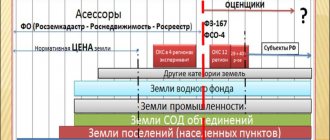
The cadastral valuation of land plots is based on the principle of their classification according to their intended purpose and type of functional use. All land plots within the lands of settlements, in accordance with current legislation, are divided into 17 types of permitted use. As part of a settlement, all lands are divided into administrative-territorial units, and within such units the corresponding cadastral quarters are allocated depending on the size and specifics of the corresponding territorial unit. The unit of measurement to which the determination of the cadastral value of each specific plot is tied is the specific indicator of the cadastral value of 1 square meter. This indicator is determined for each cadastral quarter in the context of each specific type of permitted use. That is, in relation to the lands of settlements, the specific cadastral value is determined for 17 permissible types of permitted use in relation to each cadastral quarter. The cadastral value of a specific land plot is established by multiplying the specific indicator of the cadastral value approved for a given type of permitted use of land plots in relation to the cadastral quarter in which the plot is located by its area. Moreover, if several types of permitted use are established for a land plot, then to determine its cadastral value, the specific indicator whose value is greater is selected.
5. Examination of the report on determining the cadastral value.
6. Approval by the executive authority of the constituent entities of the Russian Federation of the results of determining the cadastral value.
7. Entering the results of determining the cadastral value into the state real estate cadastre.
Thus, the main factors influencing the cadastral value of a particular land plot are:
· its type of permitted use, determined in accordance with the procedure established by law;
· the size of the specific cadastral value indicator determined for a specific type of permitted use in relation to the cadastral quarter.
The type of permitted use of a land plot is established by acts of state authorities and local self-government (orders on the provision of land? lease and sale agreements, acts of selection of a land plot, etc.). At the same time, the assignment of a land plot by the specified acts to a specific type of permitted use is subject to the following rules. The permitted use of a land plot must correspond to the functional purpose of a real estate object built in accordance with the established procedure on this land plot. In turn, the functional purpose of the object is determined by an entry in the technical inventory documents and must correspond to the purpose indicated when the facility was put into operation. Let us give an example: if a building is located on a land plot, the technical passport of which indicates the functional purpose of “Office”, then the site will be assigned to group No. 7 - Land plots intended for the placement of office buildings for business and commercial purposes. If the land plot is not developed, any of the 17 provided types of permitted use may be established for it, subject to compliance with the requirements of urban planning and sanitary protection norms and rules.
Possibility of challenging the meaning
When calculating the value of a specific indicator, objective factors are taken, but they are processed using generalized statistical methods. For this reason, the resulting result may exceed the acceptable standards and expectations of the owner of the property.
If the owner of the site disagrees with the calculation methods and results , the issue can be resolved by submitting an application:
- To the dispute resolution commission;
- To court.
All necessary information about the cadastral value can be requested in person or via the Internet from the Unified State Register of Real Estate.
If you receive a result that affects the interests of the owner, you can request clarification.
To assert your rights, you need to order an additional regulatory assessment . If its results do not coincide with the “state” one, you can start an appeal and prove that:
- When assessing the site, unreliable data was used or reducing correction factors were not taken into account;
- The state examination was carried out in violation of the State Examination Methodology. examination of land management documentation. This is also a reason that allows you to appeal and cancel the decision to approve the technical documentation.
The period for consideration of a request to revise the price of a plot is 30 days from the date of filing the application.
How to calculate?
The calculation of UPKS itself is carried out according to the following algorithm:
- Assessment groups are formed from plots located on one cadastral block in one locality.
- For the formed assessment groups, a number of price-forming factors are identified, and the degree of influence of each of them on the market price of plots is determined.
- A specific indicator is determined for each group.
- The cadastral value of each object is calculated using the formula:
KS = UPKS x plot area .
Of all the land plots located on one territory, the following are distinguished:
- dacha and gardening partnerships;
- associations of gardeners or gardeners where construction is permitted;
- personal farms where construction is permitted;
- residential buildings separately for each category (multi-storey, apartment, mid-rise, individual buildings, etc.);
- agricultural plots;
- plots occupied by infrastructure, etc.
After grouping the plots, the appraiser determines the SDC for each group. The expert identifies factors influencing the value of objects in each group. Then a standard is selected - a land plot with typical characteristics. From the standards, subgroups are created for which information is collected - analysis of supply and demand in the domestic market.
The appraiser develops a statistical model, identifying the dependence of market value on pricing factors. After this, a formula is generated for calculating the specific indicator, and the UCS for the standard is calculated. In general, the formula looks like this:
UPKS = (Ppos+Rtransactions) x Ki , where:
- Rpos – infrastructure indicator (reflects the cost of utilities present on the site);
- Transactions – market price of the plot;
- Ki is the correction factor for a given plot.
The market price is calculated by multiplying the inventory value by an adjustment factor that takes into account the improvement of a given plot (advantageous location, proximity to infrastructure facilities, etc.). We wrote about the market value and how it differs from the cadastral value in a separate article.
The last step is to calculate the final value of all plots of the assessment group, which included the standard, by multiplying the indicator obtained in the calculations by the area of the plots.
To take into account the influence of negative factors, reducing correction factors are used (for example, when the site is located in a zone of probable flooding, etc.).