If the required data about the requested area cannot be found out using a cadastral map, then you need to send a written request to Rosreestr and find out the reason for the situation.
For a number of reasons, the allotment may not be taken into account and, accordingly, not entered into the general file database.
After discovery, many people ask the question: “Why is my plot not on the cadastral map and what should I do?”
We will talk about this in the article.
What is a public card for?
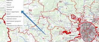
A map of land plots is an electronic file cabinet where information about each object registered for a specific enterprise or citizen is stored. Anyone can gain access to primary information. The database includes all registered land plots, data on which is in the real estate cadastre of the Russian Federation.
To work with the map, the service provides simple functionality that allows you to find cadastral division units, objects of interest and obtain information from the archives of the State Property Committee.
Using an electronic card you can get:
- detailed information on a specific real estate property;
- cadastral division, find out the boundaries with adjacent territories;
- whether the site belongs to zones with special conditions of use.
It is extremely important to know in advance if a property is allowed to be used with restrictions.
also worth finding out information about neighboring adjacent territories so that there are no restrictions on them. Otherwise, it will be impossible to engage in any type of activity on the land due to its proximity to special objects, which makes the purchase impractical.
If the plot number is known, then its location and boundaries with neighboring lands can be established.
Using the service is similar to searching in Google Maps.
But in addition to the address, numbers assigned to objects are used.
The public cadastral map allows you to find out only primary information about the site .
Information is provided about whether a specific plot exists, in what area it is located and whether it has official registration.
The cadastral number assigned to each object is a number consisting of several parts. By number you can determine whether you belong to a particular region.
If the address of a building or land plot is known, then it is easy to determine its cadastral number or vice versa:
- The first digits indicate the county
- second - district
- 3rd part – quarter
- 4th – section
After the object is found and appears on the screen, you can get more detailed information by clicking on it.
The map is presented to scale with easy-to-use visualization tools for viewing. Using an electronic card index, you can view satellite images of the area, digital topographic maps and orthophoto coverages .
If you need information about the status of an object, you can find out this information. An object can be accounted for, previously accounted for, or temporary.
A technical error
The house is not displayed on the cadastral map - the problem may lie in a typo. If there is a plan, but there is no information on the map, incorrect information was entered into the document, making a mistake. What to do in this case:
- Take the USRN certificate , paying attention to the fifth section.
- If any information is displayed in the section, please contact the registration authority.
- Make sure that the certificate contains a site plan.
If there is no plan, submit an application to the registration authority.
Important! If a sufficient amount of time has passed since the formation of the technical plan, the registration authority may not accept it, since the requirements for the document are constantly changing.
Cadastral value
Using a public map, you can find out the price of an object, but not the market price, but the cadastral price , formed by Rosreestr taking into account market demand for certain real estate.
How they differ from each other can be found in the feature article.
Cadastral valuation is carried out by engineers, taking into account the location of the object, its condition and other significant factors.
Is it possible to register such land: procedure
If the territory is not registered in the cadastral register, who does it belong to, and how will this affect the registration procedure?
According to the law, any real estate must be on a single cadastral register. Otherwise, it may be recognized as a nobody’s property, that is, ownerless. Is it possible to somehow register such an “ownerless” plot? This is not an easy but possible procedure.
| Who is the owner | Description of actions |
| Municipality | The citizen found out that the plot of land not registered with the Unified State Register is actually the property of the municipality. Then, according to the Land Code of the Russian Federation, the land can be sold or leased to someone after a public auction. A citizen needs to: 1. Submit an application, addressing it to the local administration, indicating the intention to buy/lease the land. 2. Register the site (the necessary measures will have to be carried out by the author of the application): carry out land surveying, obtain a ready-made plan and technical specifications to install the necessary utility networks. 3. Participate in open tenders. They will be counted as successful even if there is only one buyer (participant). 4. Conclude a standard purchase/lease agreement and make the payment specified there. 5. Register rights as owner |
| Another citizen | The main problem here is the lack of registration. Many people ignore it, knowing that the preparation of documents and the procedure itself cost a lot of money. Especially land surveying. Perhaps the citizen-owner will agree to the deal proposed by the buyer, but in return will shift the costs associated with the necessary registration to him. Then the interested buyer, taking the seller, will carry out all the necessary procedures. The purchase of a separate plot will become possible only after its registration. How to do it: ● initially conclude an agreement where the buyer will transfer a target loan to the seller so that he can use these funds for registration; ● enter into a separate agreement under which he will accompany the seller while he is engaged in accounting |
| SNT | Moreover, the organization agrees to transfer the site. Here the citizen will first have to pay off all existing debts accumulated by the previous owner. Otherwise, the board addresses all complaints to him |
| empty land | Find the owner, and at the same time eliminate all possible risks associated with the further registration procedure. Any agreement will require consolidation using legal methods |
By the way, if initially a person only used the land without being its official owner, then, after 5-15 or more years of its conscientious use, he has the right to register himself as the owner. Such a right is recognized as “acquisitive prescription”.
Why might the allotment not be in the database?
For some reasons, information about the site may not be in the cadastral database.
To find out why this happened, you need to make a request to Rosreestr in writing.
There may be a missing registration , which can be easily fixed.
Another reason for not entering a site may be land surveying carried out before 2001 .
To eliminate the cause, you need to contact the state registration service and schedule a new survey.
The same procedure is required if there is no data on the boundaries of the site.
It is worth noting that real estate transactions can be carried out even if the site is not on the public map. Any party can appoint land surveying.
What to do if registration is missing?
If information about the site is not on the electronic cadastral map due to the fact that the object is not registered in a certain legal manner, then to correct the situation the following must be done:
- carry out land surveying;
- collect documents (the list depends on the method of obtaining the land: inheritance, donation, purchase, sale, and so on);
- submit to Rosreestr documents, land surveying, the applicant’s passport and a receipt for payment of the fee
After reviewing the request, the owner of the site will receive a document confirming ownership rights . Rosreestr employees will then mark the plot of land on the public cadastral map.
If surveying was carried out before 2001
There are situations when a plot is assigned a cadastral number, it is the property of a citizen (there are title documents to confirm this), but there is no information about it on the electronic map.
The reason for this may be land surveying if it was carried out before 2001, that is , before Law No. 28-FZ of 01/02/2000 came into force.
But at the same time, No. 221-FZ of July 24, 2007 contains a provision according to which plots that were properly registered before the act came into force are previously taken into account.
Information about these lands will be entered into the cadastre after the owner applies to Rosreestr and provides title documents.
The citizen may be required to re-define the boundaries of the site, that is, carry out land surveying again.
If there is no distinction
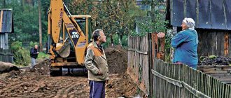
When information about an allotment is not entered due to a lack of information about its boundaries, then the citizen must carry out a land surveying procedure. To do this you need:
- Collect documents confirming ownership.
- Conclude an agreement with a land management organization . It is recommended to agree in advance on the terms of surveying, the cost of work and the payment procedure.
to delimit a site on your own without the appropriate license .
After the work is completed, the owner of the site will receive two copies of the survey file, one of which must be transferred to the cadastral chamber.
There is no technical plan - what will happen?
If there is no document describing the property and its position in space, owners may face the following problems:
- Inability to sell a residential property.
- Problems with identifying real estate.
- It is difficult to prove that the object specified in the documents is located in the specified memory (there is no link).
- inability to connect the house to heating, water supply and other communications.
A technical plan is needed when filing an appeal to the court, in this way it can be proven that a specific object is located on a specific site. (the technical plan is in the extract from the Unified State Register of Real Estate , which you can order on the official website: rosreestor.online
How to find out whose land it is if it is not registered
List of organizations where interested citizens can contact:
- EGRN – first of all. From there it is easiest for a citizen to obtain basic information. How much a piece of land you like might cost, who is the owner. When there is no information, it means that the site is not registered.
- Neighbors will also tell you whether it is private property or a gardening association.
- SNT is the closest, they have their own records, which describe the plots and the details of their owners (tenants).
- Municipality. It is worth contacting if the land is not listed with SNT, and there is also no data in the Unified State Register of Real Estate. It is possible that the property is considered municipal property. Then the citizen will be able to ask for the plot he likes to be allocated.
- Tax Inspectorate. Any landowner has tax obligations. This means he is listed as a taxpayer. The inspectorate has all the necessary data, but tax officials cannot disclose it.
- Media - make an announcement in some local newspaper or post a post with a description and photographs of the land plot online. Why not? Perhaps this way the owner will show up faster.
The act of agreeing boundaries with neighbors
After receiving the boundary plan, the land plot must be registered in the cadastral register. To do this, the owner needs to prepare a number of documents. Among such papers there should be an act of coordination of the boundaries of the site with the neighbors. Usually such an act is drawn up and signed during boundary measurements, but there are times when this paper is lost sight of. Most often, such a problem arises due to elementary inattention. That is why, having discovered a mark in the cadastral passport about unidentified boundaries of real estate, you should immediately contact specialists on the issue of coordinating land surveying.
Boundary coordinates
The coordinates of the boundaries of a land plot actually mean a clearly specified indication of the location of passing contour lines that define the boundaries of the plot and distinguish it from the total mass of land.
Considering the definition of “boundary coordinates”, it is worth noting that cadastral engineers more often use the concept of coordinates of boundary turning points.
This is due to the fact that the boundaries of the site themselves essentially act as lines that are drawn between established reference points - that is, the location of the site and its boundaries are determined, then the points are established where a straight line stops and another begins.
Thus, the cadastral points determined by the cadastral engineer during the work serve as coordinates.
list of accredited specialists
Establishing the coordinates of boundaries or the coordinates of turning points is possible only if the surveying procedure is carried out, all necessary steps are completed and a case is formed, an important component of which is the boundary plan