Ownership of a land plot is one of the rights of a property owner. Its full implementation is possible only with a clear identification of a plot of land by establishing territorial boundaries.
A dispute over the boundaries of a land plot is a fairly common situation that arises between owners of adjacent plots. Often neighbors cannot agree on where the boundaries of their plots lie and who owns specific land. The procedure for resolving conflicts over the boundaries of adjacent plots of land has certain rules and features, which should be considered in more detail.
Basic concepts and regulations
According to paragraph 3 of Article 6 of the Land Code of Russia (hereinafter referred to as the Land Code of the Russian Federation), part 7 of Article 38 of the Federal Law of the Russian Federation dated July 24, 2017 No. 221-FZ “On Cadastral Activities” (hereinafter referred to as Law No. 221-FZ), a plot of land is determined by part of the land surface having certain individual characteristics. The legislation establishes that, as the main identifying feature, a land plot must have precise boundaries determined during the land surveying process.
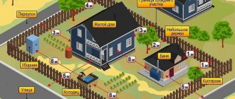
Land boundaries are the lines or edges that define the territorial location of a property. There are boundaries:
- Actual - currently available (fences, ravines, enclosures, other artificial barriers).
- Cadastral - taken into account during cadastral registration.
- Legal - determined as a result of the land surveying procedure, but before the site is registered.
- Historical - determined at the initial location of the plot.
- Decorative - taken into account by the state before land surveying.
In accordance with the above laws, land surveying is a mandatory procedure carried out when agreeing on the exact boundaries between adjacent land plots. Article 39.3 of Law No. 221-FZ states that the owner of a neighboring plot of land does not have the right to object to land surveying and prevent the establishment of clear territorial boundaries of the property. The procedure does not require additional costs from land owners and is carried out free of charge.
As a result of the process of delimiting nearby areas, an act is drawn up, signed by all interested parties. The document drawn up is the basis for entering information about border land plots into the Unified State Register of Real Estate (USRN).
Important: if the neighbors could not come to an agreement regarding the boundaries of their lands, further resolution of the conflict will require litigation.
Causes of disputes over land boundaries
A dispute between owners of border land plots can arise not only in the process of determining the territorial lines of a plot (land survey), but also during its use.
The most common reason for disputes between neighbors is the discrepancy between the boundaries indicated in official documents and those that actually exist. In such cases, the boundary lot lines may:
- cross;
- overlap each other (overlapping the edges of the area);
- partially absent.
Table. Frequent cases of disagreements regarding the boundaries of land plots:
Types of disputes and features of their consideration
The main types of conflicts arising over the boundaries of land plots are:
- Contradictions in the original documents are quite common, since the previous methods used in the land management process were not highly accurate, and their result was the determination of only approximate boundaries. In this case, new surveying will be required to establish precise boundaries, which often changes the actual lines of the site.
- An error made by a cadastral engineer when determining the initial edges of the plot. The situation arises due to incorrect measurements or erroneous entry of data into documents. As a result, there is a violation of the rights of the owner and the emergence of various disagreements between neighbors of adjacent lands.
- The most common type of dispute regarding borders is the seizure of land by the owner of the border plot, which can be expressed in the illegal transfer of a fence or fence, as well as part of the building, to a nearby land plot.
There are nuances when considering various types of disputes over land boundaries. Land surveying must be carried out with the participation of all persons interested in the process, or the fact of written notification of the date. If the procedure prescribed by law is not followed, the neighbors’ chance of resolving the dispute in their favor is significantly reduced.
Previously, before registering an allotment with the state, it was necessary to obtain consent from all owners of border plots. Now the procedure has been significantly simplified - in the absence of disagreements or the neighbor’s silence, the plot is put on cadastral registration. As a result, there is a possibility that the State Register will contain erroneous data. If the registration authority refuses to make changes to the Unified State Register, this can be appealed in court. You can challenge an error when registering a land plot for cadastral registration within three months from the date of refusal by the authorized body to eliminate it.
Which court should I go to with a land dispute on the boundary of a plot?
If a dispute arises regarding the determination of the territorial lines of a land plot and it is impossible to resolve the conflict peacefully, you must go to court. The jurisdiction of land disputes along the boundaries of plots is determined by law - such cases are considered by the district court.
The purpose of the trial is to determine and establish the exact boundaries of the land for its subsequent state registration with Rosreestr. To initiate the process of resolving a land dispute in court, it is necessary to file a claim and attach the available evidence. Upon acceptance of the application, the judge issues a ruling on preparation for trial. The owners of border areas and all interested parties must be involved in the process of considering the case in court.
Contact Rosreestr
The legal owner of the site whose rights have been violated can file a complaint. The application must be submitted to the Rosreestr office at the location of the land.
An application can be submitted:
- personally;
- by mail;
- on the Rosreestr website.
A complaint to Rosreestr cannot be anonymous. Therefore, the applicant must indicate his full name. and return address to receive a response. The response will be sent in writing within 30 days from the date of acceptance of the application by the department.
Liability for illegal use
The protocol on bringing to administrative responsibility is considered by the administrative commission of the municipality. As a result, the violator will receive a fine and an order to eliminate the violation.
Responsibility for the seizure of public lands is established by Art. 7.1 Code of Administrative Offenses of the Russian Federation.
The procedure for calculating the fine if the cadastral value of the plot is determined:
- for a violator - an individual - from 1 to 1.5% of the cadastral value, but not less than 5,000 rubles;
- for an official - from 1.5 to 2% of the cadastral value, but not less than 20,000 rubles;
- for legal entities - from 2 to 3% of the cadastral value, but not less than 100,000 rubles.
If the cadastral value is not determined:
- for citizens – from 5,000 to 10,000 rubles;
- for officials – from 20,000 to 50,000 rubles;
- for legal entities – from 100,000 to 200,000 rubles.
The order is issued for a period of 6 months. If the violation is not eliminated during this time, the fine is issued again and the order is repeated.
The procedure for resolving disputes over the boundaries of a land plot
The main facts that must be proven when resolving a dispute over land boundaries are:
- determining the ownership of land plots by each of the parties to the dispute;
- contiguity of plots;
- actual change in land lines compared to those previously established and indicated in the documents;
- circumstances and reasons that served as the basis for changing the boundaries.
Important: in court, the plaintiff is obliged to prove the ownership of specific land to each of the participants in the process, while the defendant, for his part, must prove the absence of signs of illegal behavior in his actions.
During judicial consideration of land disputes along the edges of the earth, the following can be presented as evidence:
- title documentation;
- expert opinions;
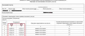
- plans for border areas;
- general cadastral plan of the site with an appendix showing adjacent lands;
- other evidence (archival documents, witness statements, plans for the location of buildings, assessment of soil differences in areas).
To resolve a conflict regarding the territorial lines of adjacent land plots, special knowledge is required, therefore the most accurate evidence in court is the result of a land management examination.
When resolving a dispute, the court takes into account the boundaries that have actually developed and have been demarcated for more than 10–15 years before disagreements arose between neighbors. In most cases, such territorial lines are fixed by natural or artificial objects and have existed for more than one year, and sometimes even several decades. Such situations are common when land surveying methods were not quite accurate.
Common land between neighbors in a private house - what is it?
The concept of public lands is given by Art. 1 of the Town Planning Code of the Russian Federation. These are territories that can legally be used by an unlimited number of people. Public lands include:
- streets;
- embankments;
- boulevards;
- squares;
- squares;
- driveways.
The boundaries of public lands are called red lines. The owner of this territory is the municipality. If the territory is located within the boundaries of TSN, then TSN will be considered the owner of these lands.
Features of public lands:
- If public lands are not fenced by the owner and there is no ban on free access, then any citizen can be present there legally. At the same time, he is obliged to ensure the safety of property and natural objects located on this site.
- The law prohibits leasing public areas, allowing their privatization or selling them.
- Federal and regional legislation applies to public areas. Therefore, individual nuances vary depending on the region.
What is the limitation period?
If a citizen owned a plot of land, but did not use it for various reasons, this does not mean that someone is allowed to encroach on his plot. You can lose the right to own real estate or lose the right to a part of it only as a result of alienation or by a court decision that has entered into legal force.
The situation is different if the old-style certificate of ownership contains erroneous or inaccurate information. This is often why disagreements arise regarding the definition of exact boundaries.
It does not matter when the owner of the land became aware of the illegal use by another person of his land or part of it. If such information becomes known to the legal owner, he can go to court to demand clarification of the boundaries.
Regardless of how long ago the violation is, the true owner can try to resolve the dispute out of court. If the parties do not have a desire for a peaceful resolution of the conflict, the owner must go to court. To apply to the court, you need a basis - a document indicating the plaintiff’s right to the land plot.
Example 2. Walked through someone else’s property - pay
It is, of course, impossible to walk or drive through a neighboring plot of land without the consent of its owners.
But what if you can only get to your site through your neighbors’ site and there are no other options? The woman purchased such a plot and for some time the neighbors allowed her to drive to it on their land. But then the relationship deteriorated and they closed the passage, demanding payment.
The court partially supported both sides. Neighbors are required to grant the right of limited use of their plot to their neighbor and register the so-called. easement.
The law provides that such an encumbrance in the interests of the owner of a neighboring plot is permissible if he has no other way to get to his plot.
But, on the other hand, once you get the right to use someone else’s land, you will have to pay for it (Article 274 of the Civil Code of the Russian Federation). The court determined the amount of payment in favor of neighbors for the easement in the amount of 33,650 rubles per year (Vsevolozhsk City Court of the Leningrad Region, case 2-27/2019).
Judicial practice on land disputes related to land surveying
The established judicial practice on land disputes is systematized by the Plenum of the Supreme Court of the Russian Federation. The most common mistake made by judges when resolving land disputes related to land surveying is violation of the procedure established by law:
- non-involvement of owners of adjacent lands as parties, which prevents a comprehensive and complete, thorough analysis of all available evidence;
- not assigning a land management examination.
For example, the district court heard a case in which the plaintiff’s demand was to invalidate the land surveying of a neighboring plot of land and the demolition of a self-built building in the form of a barn located on the applicant’s land.
Initially, the judge granted the plaintiff's demands, but later the decision was overturned by a panel of judges due to the lack of expert results in the case. A land survey carried out at the request of the defendant showed other territorial lines that did not affect the constructed structure. The claims were denied.
In another case, during the initial consideration, the co-owners of the disputed property were not involved in the case. The panel, overturning the decision of the district court, took into account that the land plot is in common ownership of several persons. During the re-examination, the court brought all co-owners on the side of the defendants.
Lawyer's answers to private questions
Neighbors built a store on public land near the house. Cars drive up to the store and block the passage to my house. Where to complain?
In this situation, you need to file a complaint with Rosreestr, the district administration and the prosecutor's office.
We live in the private sector. The neighbor pulled the fence up to the road. It is almost impossible to get to the house. What to do?
File a complaint with Rosreestr. The neighbor will be held accountable and forced to return the fence to its place.
There was a passage between the sites. The neighbors moved the fence and closed it. I started driving to the house through the territory of the enterprise, which is located on the other side of the site. But now they want to ban travel through the territory of the enterprise. This means I won't be able to drive home. What to do?
According to the layout, it cannot be that there is no access to the site. Contact the district administration and look at the urban planning plan. In it you will find legal access to the house. After which you need to file a claim against the person who blocked this passage.