When executing site planning and master plans, you must navigate a variety of statutes, codes of practice, and state and local design codes.
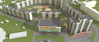
And with calculations of the building density and population density of a residential area or block (neighborhood), work begins on the planning and land surveying project.
Many years of experience in designing cottage, low-rise and multi-storey residential buildings allowed me to create this short article to help my fellow designers: architects and general planners.
Indicators of building density must be calculated at all stages of design: territorial planning projects (PPT), land plot plans (LPP), master plans (GP).
I will try to provide as complete and detailed examples of calculations of building density indicators for a specific residential area, with references to design standards.
You can download some regulatory documents (SP, SNiP) at the beginning of this article.
Who installs
The maximum size of a plot is determined by several legislative standards, among them Article 11.9 (clause 1) of the Land Code and Article 30 (part 6) of the Civil Code. There are also legislative provisions that set maximum land sizes.
- At the federal level, the size of land that is owned by the state, the Russian Federation, is determined.
- If the land is the property of the subjects of the Federation, it is used when determining the area by the laws of the region.
- The laws of local authorities indicate the maximum size of plots allocated from municipal lands.
Calculation of neighborhood population density
The estimated population density of a microdistrict with multi-storey complex development and an average housing supply of 20 m2 per person should not exceed 450 people/ha. (Clause 7.6 SP 42.13330.2016).
We determine the estimated population density of our block with a housing supply of 30 m2/person:
450x20/30=300 people/ha
We determine the actual population density of our quarter:
Rnas.=Kzhit/Sterr.=1037/5.31=195 people/ha.
195 people/ha is less than the standard 300 people/ha: meets the standards.
Maximum limit size
This expression includes several concepts, this is not only the area of the plot itself, but also the regulatory setbacks of buildings from the boundaries of the plot, the maximum percentage of development within the boundaries of the land plot, and the permitted number of floors.
Such norms are specified in urban planning regulations established in each locality by local authorities. To find out what established standards apply in your city or town, you need to contact the authorities, the municipality.
Watch the video: New law on gardening and horticulture
In different regions, the maximum and minimum sizes of land allocated for individual construction differ. But the average number of acres allocated for a house is 3. The number is small, but you need to check with the authorities dealing with land issues, perhaps you can get a more spacious area.
When allocating a plot of land for individual housing construction, its new owner may encounter a number of problems, in particular, conflicts that sometimes arise with neighbors and owners of adjacent plots.
If you know the rights of the owner and the rules by which land is allocated, the established maximum size of the plot for building a house is determined, the conflict will quickly be resolved.
10 percent rule for increasing area in GPZU - a new simplified procedure
Amendments to the general plan of the site are permitted in a simplified manner. The grounds for this are indicated in paragraph 3.3 of Art. 33 Civil Code of the Russian Federation:
- if, as a result of the application of the PZZ, harm is caused to copyright holders, the value of the land of the objects is reduced;
- if a one-time change of type of use is necessary (without changing the permissible parameters of the object);
- if you need to change the type of use with a one-time change in the parameters of permissible construction, but not more than 10% compared to the site regulations.
The last point is especially important, since it can be used in the interests of developers and during reconstruction with an extension or superstructure.
Making changes to the general plan in a simplified manner allows you to do without holding hearings or passing the City Commission. For example, in this way you can immediately contact MosKomArchitecture to increase the building area. All procedures will go much faster. If you need to make changes to the master plan in a simplified manner, our specialists will provide assistance in preparing documents.
By the designations on the PZZ maps you can understand with what permitted types of activities the facility can be built
How is it determined
The Land Code undergoes changes from time to time, which is associated with changes in the realities of life. And you need to follow such innovations, especially for those who are related to the land, are the owner of the plot, or are planning to write an application for the allocation of an allotment.
In 2015, an innovation appeared regarding the annexation of lands located next to one’s own plot.
ATTENTION! Now you can write an application to annex the territory that is located next to the site and has been cultivated by you for a long time. It is important that such land does not have an owner.
The procedure for calculating the coefficient
Since residential buildings and other facilities within populated areas are built next to industrial buildings, roads and sometimes even highways, it is necessary to calculate the required number of square meters of premises to meet all the needs of the population. Such calculations cannot be carried out by private individuals, since the purposes of the calculation are of public importance.
Employees of these authorized public services are constantly looking for new ways to locate buildings and structures within cities in order to meet the needs of the population and at the same time comply with development standards at the maximum permissible level. For these purposes, they use various technical and economic characteristics of the area.
Today there are two ways to determine the coefficient:
- gross method;
- net method.
The gross method has the following features:
This method implies the relationship between the total area of the planned development and the entire territory necessary for the life support of a residential area.
According to the gross method, the coefficient is expressed as a percentage.
The calculation by the net method is characterized by the following:
Using this method, the calculation is made by relating the entire area of the building to the area of the required residential premises. That is, in this case, only the area of buildings intended for residential apartments is taken into account.
To calculate the area of residential buildings, the area of buildings and other social, economic and cultural facilities is subtracted from the total area of a block or district.
In this way, it is possible to calculate the required area of buildings for the needs of the population, taking into account the number of people living in a particular quarter.
To calculate the coefficient for the construction of apartment buildings, the area is determined by the external boundaries of the walls of the building. Only the above-ground areas of apartment buildings are taken into account.
Change in area
There are already rules governing the process of annexation and establishing the maximum size of the territory that can be annexed to the site. Such redistribution rules, as well as restrictions, are specified in Articles 39.28 and 39.29 of the Land Code of the Russian Federation.
- You can add land to a site with a building if there is a need to bring the area of the site into line with the land survey boundaries. But you need to have a project that considers the development and improvement of the territory.
- You can also make a request for redistribution of land area if your plot needs to be protected from wedging or fracture. At the same time, the permissible maximum dimensions of the site for a particular type of activity cannot be exceeded.
- It is allowed to increase the total area by adding a piece of land if gardening, vegetable gardening, or personal subsidiary plots are being developed on the site. A valid reason is also the construction of a house for personal residence, or dacha farming.
The Land Code allows redistribution with an increase in land area and when capital construction is planned on the site.
Redistribution is carried out in this case with the seizure of land in favor of the state. In this case, an agreement is signed between the two parties to the operation (the land owner and the state).
IMPORTANT! It is necessary to change the boundaries and increase the area with the land surveying procedure, because you will need to obtain the appropriate cadastral passport.
What it is
This coefficient recognizes the numerical ratio between the entire area of a plot of land and that covered by the area of the future or existing building. Otherwise, this coefficient is also called building density.
Usually the calculation is made taking into account the number of square meters of suitable and unsuitable premises for living in relation to one hectare of land. This calculation is used to determine density in entire areas and neighborhoods for the interests and purposes of the state.
But even when constructing or calculating the development coefficient of private properties, experts proceed precisely from the ratio of square meter per hectare, regardless of the total area of land ownership. In most modern cities and towns of other types, the building density is 20% or more. But even in Moscow this figure has not yet exceeded 60%.
Calculation of the coefficient is necessary to determine some parameters of a newly constructed structure. It is on this that the parameters of the building’s foundation and the future load of utility networks and networks for other purposes depend.
Typically, the following types of coefficients are distinguished:
- construction ratio;
- building density coefficient.
The coefficient denotes the ratio between the area of buildings at the base and the entire plot of land, while the density coefficient denotes the ratio between the area of the site itself and the square footage of all premises.
Minimum limits
Maximum sizes can be established by laws adopted at the level of the state, constituent entities of the Federation, and municipality.
It depends on who owns the land. Local authorities, including in the Moscow region, adopt urban planning regulations that should not contradict state legislative standards.
In the Moscow region, the last such regulation was adopted in 2003. According to this legislative document, the minimum size of land in the region for farming is 4000 hundredths, for dacha construction - 25 acres, for gardening - 15 acres. In each district of the region, standards were adopted for the maximum limit size of the plot, which will also depend on the type of management on the land.
In the Leningrad region, the minimum plot size for livestock farming is 500 acres. And anyone who wants to build a dacha will receive a minimum of 10 acres.
This is interesting: What is TSN in gardening?
Categories and parameters of highways of settlement systems
Road categories
| Design speed, km/h | Lane width, m | Number of lanes | Minimum radius of curves and in plan, m | The greatest longitudinal slope, | Maximum width of the subgrade, m | |
| Trunk: | ||||||
| high-speed traffic | 150 | 3,75 | 4-8 | 1000 | 30 | 65 |
| main sectoral continuous and regulated traffic | 120 | 3,75 | 4-6 | 600 | 50 | 50 |
| main zonal continuous and controlled traffic | 100 | 3,75 | 2-4 | 400 | 60 | 40 |
| Local significance: | ||||||
| freight traffic | 70 | 4,0 | 2 | 250 | 70 | 20 |
| park | 50 | 3,0 | 2 | 175 | 80 | 15 |
| Notes 1 In difficult topographical and natural conditions, it is allowed to reduce the design speed to the value of the next category of road with appropriate adjustments to the parameters of horizontal curves and longitudinal slope. 2 If traffic flows are highly uneven during peak hours in different directions, it is permissible to construct a separate central roadway for the reverse movement of cars and buses. 3 On main roads with a predominant traffic of trucks, the width of the traffic lane should be increased to 4 m, and when the share of heavy vehicles in the traffic flow is more than 20% - to 4.5 m. |
Appendix K
(recommended)
When are norms used?
The adoption of standards for maximum and minimum sizes is regulated by the Town Planning Code of the Russian Federation. Each territorial zone also introduces its own urban planning regulations that determine the allocation of municipal lands.
The following size limits are observed when selecting all areas:
- They are necessarily taken into account when creating new plots from state or municipal lands.
- When allocating land upon application to an individual or legal entity for individual residential construction, for the construction of a summer house or for gardening, vegetable gardening, or farming activities.
- Size standards can also be used when dividing a plot into several, when resolving the issue of cuttings.
- Size standards are also taken into account when forming a plot from an unclaimed land share.
Town planning regulations
It is possible that local authorities have not adopted urban planning regulations, but the size of the plot when allocated must still comply with legal standards . What documents are taken into account in this case?
- It is necessary to consider the articles of the Land Code that address this issue.
- Urban planning codec of the Russian Federation, adopted at the state level.
- The Federal Law “On Personal Subsidiary Farming” No. 112, adopted in 2003, will also help.
- Federal Law “On Farming” No. 74, adopted in 2003.