Home / Real estate / Land / Size of land
Back
Published: 11/16/2017
Reading time: 10 min
0
735
General requirements for land plots for individual housing construction are formulated in the Land Code of the Russian Federation. In each region there are regulations that define the minimum and maximum sizes of plots.
- Norms and regulations
- Minimum territory size for individual housing construction
- Maximum size of land plot for construction of a residential building
A land plot for individual housing construction is a land plot on which the construction of a separate residential building, no more than 3 floors high, owned by one family, is legally permitted.
What do the limits depend on?
Limitations on the size of the allocated plot are taken into account if it is provided free of charge from the state or municipal real estate fund.
When determining the maximum size of the allocated plot of land, a number of factors are taken into account , including:
- the possibility of free provision of land to preferential categories of citizens;
- the number of people who will live in the residential building;
- demand for land;
- the total area of land owned by the municipality that can be allocated for individual housing construction;
- level of economic development of the region;
- population density.
Reference! In the Moscow or Leningrad region, the land plot norm will be lower due to the density of buildings than in Siberia or the Far East, where there is a large amount of land for housing construction outside the city.
Legal aspect
The legislative framework has been significantly adjusted in recent years, which makes it possible to quickly resolve controversial issues.
Most often they arise as a result of:
- entry into inheritance rights when several owners appear at once;
- after the divorce of spouses whose rights to property are divided equally;
- desire to sell your share after it is allocated;
- intentions to carry out a transaction for the exchange, donation or sale of part of the plot.
The division should not lead to the minimum value becoming less than that established by law. The main provisions are found in the land code.
In particular, it states here that:
- The size of the plot depends on its purpose (Article 33. Norms for the provision of land plots). This is farming and peasant farming, gardening and vegetable gardening partnerships, country house construction and raising various types of livestock or poultry. After allocation, private individuals have the right of ownership of land (clause 1).
- The maximum size (clause 2) varies somewhat and is determined by federal laws and local regulations. In some cases (clause 2.1) a gratuitous transfer is stipulated, affecting large families. There are also a number of restrictions (clause 3).
- The boundary dimensions and location of the plot should not violate accepted standards and extend beyond the territory of the populated area (Article 11.9. Requirements for created and modified land plots). The land must be suitable for exploitation. Cutting that leads to wedging, striping or encroachment into forest parks and nature reserves is unacceptable.
- The procedure for obtaining a cadastral plan and passport follows a certain scenario (Article 11.10. Layout of a land plot or land plots on the cadastral plan of the territory). The concept of a scheme, the number of required documents, the participation of other persons in the registration process, the preparation of media, the rights of the owner and the actions of local authorities are spelled out.
- There are restrictions for certain categories of land (Article 27. Limitations on the turnover of land plots) provided for natural parks, burial sites, the location of military units, communication lines, roads and railways.
The first step is to pay attention to local regulations on land use, urban planning and development.
Dependence of size on intended purpose
Legislation at the Federal level establishes the following minimum and maximum sizes of land plots depending on the intended purpose:
| Special purpose | Minimum size, ha | Maximum size, ha |
| Farming | 2 | 40 |
| Gardening | 0,6 | 0,15 |
| Horticulture | 0,4 | 0,10 |
| Country house | 0,06 | 0,25 |
Building codes
In order for a future residential building to comply with current building codes and regulations, it is necessary to comply with all SNiP requirements on the existing land plot.
Different standards have been developed for different types of buildings and structures, types of land plots.
If you have a plot of land received from the municipality free of charge, then during construction you must take into account the following:
- Residential development should not occupy more than 30% of the total area of the plot - with a minimum land plot size, your house should be no more than 90 square meters. m., the larger the plot of land provided, the more spacious the house the developer can afford.
- On a plot of no more than 12 acres, it is allowed to build only one residential building (this requirement does not apply to the number of outbuildings).
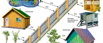
- A residential building cannot be located closer than 5 m from the street (“red line”) and 3 m from the side passage.
- It is important to comply with the requirements of SNiP 30-02-97 in relation to neighboring boundaries, residential and outbuildings:
- between residential buildings - a distance from 6 to 15 m, depending on the combination of materials for the supporting structures of buildings;
- from the house to the boundary between neighboring plots - at least 3 m;
- from outbuildings to the border of the site - at least 1 m.
If you can, taking into account all these requirements, build a house on a land plot of a minimum size, then you will not have any problems with registering ownership of real estate.
Size
Minimum
The minimum size of land plot for individual housing construction is determined in accordance with local regulations, but it must be emphasized that no regional act can contradict the Federal laws and the Constitution of the Russian Federation.
How much land is allocated for individual housing construction on average in Russia? On average in Russia, land for individual housing construction is provided in an amount of no less than 3 acres . In some regions this figure may be 2-3 times higher.
The table shows the minimum values of land area in the largest regions of Russia:
| Name of the territorial object | Minimum land area in acres |
| Moscow | Not installed |
| Moscow region | 4 |
| Saint Petersburg | 3 |
| Leningrad region | 6 in cities, 10 in villages |
| Novosibirsk | 6 |
| Ekaterinburg | 4 |
| Krasnodar region | 4 |
Limit
The maximum size of plots for individual housing construction is also set by local authorities. This indicator is influenced by whose ownership the land is - federal, regional or local, since the resources of each level are different.
Factors taken into account include:
- number of land plots;
- demand for land in a given region;
- how the sites are populated;
- general regional development.
Also, the maximum size is determined taking into account the design of the future house and the number of people who will live in it. The established parameters must not contradict sanitary and technical standards. Limit sizes of plots for individual housing construction can be found in the local administration. In each region they are different, on average in the Russian Federation this size is 30 acres.
Let's consider the maximum values of land area in the largest regions of Russia:
| Name of the territorial object | Maximum area in acres |
| Moscow | Not installed |
| Moscow region | 30 |
| Saint Petersburg | 15 |
| Leningrad region | 25 |
| Novosibirsk | 10 |
| Ekaterinburg | 25 |
| Krasnodar region | 10 |
What it is
Land plots are under the jurisdiction of state and municipal authorities. Some plots are intended for urban planning purposes, others are allocated for citizens acquiring ownership rights.
The plot passes to the owner as a result of redemption or lease from the municipality, after division or separation from the common share, which often occurs as a result of inheritance.
The dimensions are determined by both the town planning code and local regulations. Much depends on the category of land and the objectives of its further use.
The approved parameters determine:
- the size of the minimum setbacks after determining the boundaries of the plot, so that it becomes possible to fearlessly erect economic and capital buildings;
- the height of the house itself along with the number of floors (as a rule, the construction of a multi-story building is prohibited);
- the approved percentage for buildings in relation to the remaining area of the site, which must also be used for its intended purpose;
- territories where there are no restrictions related to the maximum and minimum permissible sizes.
Much depends on the purpose of the land, which is allocated for housing and summer cottage construction, farming or gardening.
It will not be possible to build a house over three floors for one family. The plot itself fits into a framework of 300 to 3000 square meters.
In each specific case, the municipal town planning code is taken into account along with land use rules and other regulations.
Sample cadastral passport for a land plot:
Measurement methods
The area of land can be determined in three main ways:
- analytical;
- graphic;
- mechanical.
Analytical
It consists in determining the area of the site based on the coordinates of the characteristic points of its boundaries. This method uses analytical geometry formulas.
In accordance with them, the area of the polygon S is determined by the formula :
S= 0.5*∑(Xi*(Yi+1-Yi-1) , where:
- Xi and Yi are the coordinates of the i-th characteristic point of the area, which has the form of a polygon.
- i is the serial number of the characteristic point. This parameter varies from 1 to n, and n is the number of characteristic points.
If the plot has the shape of a quadrangle, then the area calculation is calculated using the above formula with n=4.
If the area has the shape of a trapezoid, then its area is found using the formula:
St=0.5*(a+b)*h , where:
- a and b are the bases of the figure;
- h – height of the trapezoid.
When calculating an irregularly shaped quadrilateral, you first need to determine the value of the semi-perimeter p:
p=0.5(a+B+c+d) , where: a,b,c,d are the dimensions of the sides.
Then Su will be equal to:
Sy=√(pa)(pb)(pc)(pd).
Graphic
To calculate the area using this method, a plot of land with a complex shape shown on the plan is divided into simple sections (rectangles, triangles, trapezoids), then the areas of these figures are calculated and added together. The accuracy of the graphical method is determined by the accuracy of the graphical measurement on the plan . This method is convenient to use if the number of characteristic points is small.
If the area has a curved shape, special palettes are used.
Mechanical
Used for a large area with complex boundaries . To do this, use a planimeter, which is a device that allows you to determine the area of a flat figure by tracing its outline.
The accuracy of this method depends on the size of the site and the properties of the plan.
Attention! The area of a plot placed in the real estate cadastre can be determined using an online service called “Public Cadastral Map” by address or cadastral number.
Maximum minimum and maximum sizes of land plots
The types of use of the allotment, the maximum size of land plots for gardening, gardening, farming or building residential property are clearly indicated here.
Special attention is paid to the maximum dimensions after the following circumstances occur:
- the allotment is transformed as a result of a decision of state and local authorities;
- the transfer of a plot for rent occurs after a request from citizens or legal entities for farming and livestock farming, planting a garden and vegetable garden, for individual housing construction and a country house;
- a division or redistribution of a site occurs when it is impossible to merge with another territory;
- the new allotment occurred after the division or allocation of land intended for agricultural work;
- a plot is allocated from an unclaimed share of artificially irrigated or drained land on the basis of common ownership rights.
The final dimensions are greatly influenced by other factors.
In particular related to:
- the number of available plots and categories of land;
- increased demand for real estate that arose after the opportunity to register in your home;
- population concentration and density per square meter;
- the rapid development of the region itself, when the influx and growth of population is clearly noticeable.
The practice that existed for many years did not allow establishing exact boundaries and dimensions of the site. Everything was done “by eye” and rather arbitrarily.
Meanwhile, each plot has its own unique characteristics, which should be reflected in the register.
You can become an owner after allocating and transforming a new plot, registering a deed of gift and will, concluding a lease and sale agreement.
In no case should they exceed the norm or be less than required. Discrepancies in parameters, when the received data does not coincide with the title documents, occur periodically.
The problem can be resolved peacefully if the difference does not exceed 10 percent of the entire territory of the allotment. When it comes to maximum values, the owner will be able to purchase additional square meters from the municipality.
It is much more difficult to deal with neighbors who have not yet issued cadastre passports for their plot. The proceedings go through the local authorities, who issue an appropriate plan. This will take up to 3 months.
Only then can you register in the register, dispose of the land and think about building a house with the necessary buildings.
For individual housing construction
It is better to adhere to a certain algorithm of actions, trying to reduce the time of the procedure to a minimum.
To do this you need:
- familiarize yourself with local town planning regulations and land use rules (requirement of Article 32 of the Civil Code);
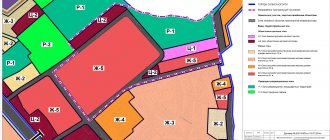
- study the zoning map to find the plot and find out the exact location along with the location of other objects (access to the plot must be provided, it cannot go beyond the territory of the settlement and district);
- read the basic conditions and requirements for development, so as not to violate the height and number of floors, as well as the size of the area allocated for the house;
- use the services of a geodetic company to draw up a demarcation plan and draw up an act indicating the exact boundaries of the site.