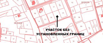
Why is it necessary to secure the boundaries of a land plot? In order to determine its clear location, and turning points. In order to put up a fence and protect your lands from unwanted intrusions. In order to comply with construction standards on your site. This list can be continued indefinitely. Boundary signs are used to secure boundaries. How boundaries are fixed, what documents accompany them, and other interesting nuances and details related to the definition and fixation of the boundaries of a land plot, we will consider in the article.
What it is?
Bringing out the boundaries of a land plot in nature is the basis of the process of land surveying, a type of topographic and geodetic services that establish, secure and formalize the boundaries of a plot with boundary signs. As a result of establishing boundary signs, the following are discovered:
- clear boundaries of the site;
- its reliable area;
- current location in the general array;
- form.
These parameters are extremely important, since on their basis a general idea of the site emerges, a visual picture is formed that corresponds to the real state of affairs, and information about the characteristics of the site is formed. The lands become legally capable and contextually compliant with the rules provided for conducting property transactions.
The origin of the concept is connected with the process being carried out , which consists in transferring the points recorded on paper (in a document, plan) that define the boundaries of the site - into nature, that is, into the real context. Why land surveying is needed - read here.
Restoring borders
To restore the boundaries, data on the registration of the site with cadastral registration and extracts from cadastral records are required, on the basis of which preliminary design is carried out in accordance with the information presented in the interactive plan.
That is, the necessary information must contain the original documentation about the site in the plan:
- its characteristic features;
- configurations;
- coordinates of turning points;
- presence and location of corners;
- total area.
After a preliminary analysis of the documentation and topographical location of the site, geodetic work is carried out on the area.
This concept is relevant both in land management activities and in urban planning, where it is necessary to accurately verify the territory for the construction of an expensive building. In addition to the designated concept, similar terms can be used:
- restoration of borders;
- restoration (installation) of boundary signs.
How much does land surveying cost? Read here.
Installation.
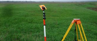
There are also requirements for the installation of boundary signs in order to ensure the constancy of their position and safety. Installation of pipes and poles - placing the coordinates in situ - must be done with the signs buried at least 80 cm. Information applied with special weather-resistant paint on the plate must display the corresponding sign number, as well as the year it was laid. The numbering of signs is carried out in accordance with land management documentation to establish the boundaries of the land management object on the real terrain. It is worth noting that the customer can determine the type of signs at his own discretion, which is established by the requirements of methodological recommendations for conducting land surveying.
Boundary signs
Geodetic work by function is not only quite complex and requires high qualifications on the part of the cadastral engineer carrying out the marking of the site. This activity is characterized by a high degree of responsibility - the slightest error in establishing boundary signs can subsequently result in long-term conflicts.
In fact, some geodetic companies guarantee an error in establishing boundary markers of no more than 10 centimeters.
The marking of the site is carried out directly on the ground . After geodetic surveying, boundary markers are installed in the form of special pegs. This procedure has options:
- Installation of special standardized stakes with the brand name of the company installing them.
- Installation of simple wooden pegs.
- Initial installation of temporary pegs, followed by their replacement with permanent ones reinforced or made of metal pipes.
These differences are due not only to the status of the company offering the services, but also to the cost of land in the general area, where lengthy legal disputes can arise for every meter of land.
Permanent boundary signs are necessary for setting out boundaries when marking large plots of land, where small pegs can easily get lost.
According to regulations, boundary signs must be made of durable material and have standard dimensions:
- length – from 80 centimeters;
- diameter 5-15 centimeters.
To avoid seizure, you can install expensive anti-vandal boundary signs . They are made of metal pipes or angles and are slightly smaller in size than standard ones. Their main advantage is the base dug into the ground, which is made in the shape of an anchor. Accordingly, moving such signs will be more than difficult.
Who can do it and is it possible to do it yourself?
You yourself will not be able to carry out the work of removing the boundaries of the land plot. Only a cadastral engineer has the right to perform such work. However, despite the fact that any engineer can have the right to do such work, not everyone can actually do it. Many engineers have received proper education, but they cannot do such work. In principle, a surveyor who has everything needed for this work can take on the job. However, no one can do it better than a cadastral engineer. If an ordinary surveyor has done his job poorly, then it will be impossible to achieve anything from him, since he does not have the official right to work.
Many people have a question: “Is it possible to check and clarify the boundaries of the site yourself and set these boundaries?” Theoretically, this is possible, since all the necessary dimensions of the plot can be found on the plan. If you have sufficient knowledge, and if you have a long tape measure, the minimum length of which is 20 m, you can easily try to do this work yourself.
However, everything is not so easy. You may have difficulty determining the boundaries of the property. Firstly, the area may be uneven and have a rather complex shape. A regular tape measure is not enough; you need special equipment. Secondly, there are situations in which there is simply no fence on the site, in which case it is impossible to determine the border. It is very difficult to establish correspondence in this case. If there is a fence and the area has the correct shape, then you can try to take on such work. However, if an error occurs, there will be no one to blame and you will still have to contact a specialist.
Removal bases
The basis for removal will be a statement from the owner of the site or a realtor preparing the site for sale.
Typically, land owners turn to these services when property conflicts arise with neighbors, when preparing cases for litigation, or if errors are identified in the use of the site. There are often cases when construction of a residential building began on a plot acquired by a citizen.
After the sale of a nearby plot, the new neighbor (let’s say on the right) carried out the removal of the boundaries of his plot. As a result, it turned out that the owner had seized part of his plot, since the neighbor on the left had stepped beyond his border.
To minimize the risks of violating the required standards, the sale of plots must be preceded by determining the actual boundaries of the plot. If a dispute similar to the above example arises, the realtor may not only become the object of serious claims, but also suffer property damage for an improperly conducted transaction.
Accordingly, when preparing land for a property transaction, it is necessary to carry out boundary work.
How to find out the boundaries of your land plot? Read here.
Step-by-step instruction
Prepare the documents available for the site. If the restoration of boundaries occurs on an already inhabited area when a dispute arises, then the documents may include from among those available:
- cadastral passport;
- old land surveying;
- title document for the site.
If these documents do not yet exist, prepare the initial act of permission for the land plot for sale (its allocation) and an extract from the cadastral records about its location and all the necessary characteristics.
The cadastral engineer, based on the documents presented to him, must adequately navigate the area.
Where to contact?
You need to contact a geodetic company. But don’t rush to sign an agreement with the first company you come across. Look at several options, call them and have a preliminary conversation with each of the providers of the services offered and choose what suits you best.
The conditions for the provision of services in all companies are not the same, and prices also vary greatly. After considering all the proposals and sketching out the main advantages and disadvantages of each of them on paper, decide on your chosen recipient.
Once the right choice has been made, contact the company with the documents. After a preliminary conversation and receiving answers to your questions, you can draw up a service agreement.
We recommend making a list of questions in advance; it would be a good idea to write them down on paper and review them during the interview process. Keep in mind that you are choosing not just a service provider, but a guarantor of your property security.
What is the price?
The cost of services for the direct removal of site boundaries is estimated at the cost of the stakes that will determine the corners of your site. For example, in the same region, different companies offered the cost of work at 500 rubles for each driven peg and 1,500 rubles for a similar service.
In addition, the more expensive option involved an additional payment for cadastral work in the amount of 200 rubles, and the budget option included their payment in your own expenses. Since there are at least 4 driven stakes, the difference in price is noticeable. In addition, more status (expensive) companies often require an advance payment of up to 70% of the total cost.
But the price sometimes affects the quality of the product. More expensive boundary signs were distinguished by their approximate compliance with the standards, while the budget ones had the appearance of ordinary planed branches, which are usually placed as temporary signs, with their subsequent replacement.
If the configuration of the site is not geometric in shape, but has an intricate pattern, there will be as many driven pegs as necessary to mark significant protrusions.
Naturally, such work is distinguished by the complexity of execution and the corresponding level of cost.
As geodetic advertisers write.
One of the presented price lists determines the following algorithm of variations, non-fixed prices for the indicated services (based on 1 peg):
- from 700 rubles when ordering more than 50 characters;
- from 900 rubles – 16-50 characters;
- from 1,300 rubles – 6-15 characters;
- from 10,000 rubles – 1-5 characters.
Deadlines
The deadlines for completing the work are established in a preliminary conversation; you will be told about these conditions immediately. Terms, as well as prices for services, vary greatly among different providers. Usually the work is completed within 10-15 days.
Some companies guarantee that work will be completed within a month, and additional payment is provided for urgent work.
After the borders are restored in kind, it will take 1-2 days to prepare the act.
The work itself can be carried out within 1 day, the rest of the time is necessary to prepare an extract from the State Property Committee.
Process description
The process of restoring boundaries is carried out after:
- conclusion of the contract;
- making an advance payment;
- submission of the required documentation.
A cadastral engineer goes to conduct a preliminary survey of a land plot to conduct a geodetic survey and establish marks and notches on the ground for their further securing.
While surveyors analyze the data and create a theoretical project, you will have to wait for the appointed day when geodetic work on the area will be carried out. At the appointed time, you will meet with specialists on the land plot and witness the topographic marking of the site.
At your representative office, measurements of the site will be taken and its exact area will be determined. On site, experts will determine the correspondences and discrepancies between the real state of affairs and what exists as information set out in accounting records or an old land survey file.
The result of the work being carried out will be the restoration of boundary markers in the area. Keep in mind that ideally each boundary marker should be provided with a unique number. All boundary marks are inviolable from third parties. They will be handed over to you against signature and under your personal responsibility.
What is the act of securing boundary marks and what to do when boundary marks are lost
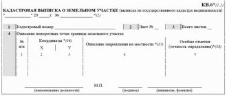
When a surveyor or cadastral engineer draws out boundaries and fixes boundary markers, he must document his action. To do this, an act of fixing boundary signs or an act of removing boundaries is written out, which records the date, location, as well as a schematic image of the land plot indicating the coordinates of the turning points. In a good way, in addition to the coordinates, the act should also include the binding of boundary signs to fixed points. This means that if there is any stationary structure nearby (for example, a lamp post, transformer box, etc.), the distance to this point is measured, which is noted in the report by the surveyor. Then, even lost boundary signs, taking into account this information, can be restored independently by simple mathematical calculations. Moreover, in case of controversial issues with neighbors, if such arise in the future, this act will confirm that the boundaries of the site are located exactly where they should be. After the boundaries are drawn and boundary signs are installed, the surveyor relieves himself of responsibility for the location of the installation of boundary signs and shifts it to the owner. If, for some reason (construction, actions of third parties), boundary signs are lost, and the fundamental structure in the form of a fence or fence is not installed, then a second visit by the surveyor is required to restore them. You can select a surveying company in the catalog of contractors, and calculate the cost of services in your region using an online land cadastral work calculator.
Act of taking out in kind
One of the most important documents as part of a land survey. It represents an unshakable basis for the legal protection of your site.
This document is drawn up upon completion of the work, after the installation of pegs at all protruding points that determine the configuration of the land plot, its area and the boundaries drawn along the line of boundary markers.
The information described in the act includes:
- The size of the total area of the site.
- Its location on the ground, with a description of the exact topographic data.
- Characteristics and detailed description of the boundaries of the site.
- Coordinates of each established boundary sign.
The act establishes the exact location of each boundary sign. It has its own description and recovery coordinates on the ground. In essence, this document is an act of acceptance and transfer of boundary marks from the cadastral engineer to the owner of the land property.
After signing the act, the boundaries of the site will be under your jurisdiction and responsibility . In case of violation of the order established by you at the boundary boundaries, you will defend your property rights in court.
How and who enforces boundaries
The boundaries are fixed by specialists in the field of land measurements - surveyors and cadastral engineers. They go to the area and, using geodetic instruments, based on the information you provide from the Unified State Register (USRN) (extended extract), draw boundaries at the given coordinates. Each turning point of the site is indicated on the ground using boundary signs, which are temporary designations of the boundaries of the sites. It is by these that builders are guided when installing fence structures.
Lawsuit for restoration
The owner has the right to protect the boundaries of his plot in accordance with the provisions of Articles 40-42 of the Land Code of the Russian Federation, as well as on the basis of his constitutional rights. He can protect these rights in court.
As a rule, claims to restore the boundaries of a site are filed in the event of a realtor’s mistake when selling a site or if conflicts arise with neighbors. In one of the cases of judicial practice, a realtor brought a family to show the plot and showed the plot for sale with a broad gesture, offering to measure 30 m to the side from the neighbor’s beds and drive a peg.
Since there was a river and a road on the other two sides, the site looked quite logical. A meticulous neighbor, whose beds did not reach the end of the plot by 3 meters according to his plan, filed a lawsuit. The case in court was dismissed due to the reconciliation of the parties after the realtor compensated the plaintiff a large sum as moral damages.
When using a plot, restoration of boundaries is carried out in the event of disputes with neighbors regarding the rights to use the plots. If you suspect or are convinced that your property rights have been infringed, you can seek justice by filing a claim in the district court where your property is located.
statements from here.
Before filing a claim, you will need to collect all documents confirming the illegal disposal of your land by your neighbors.
Consider the regulations for the use of the site and check whether they are being observed on their part.
Invite a cadastral engineer and restore the boundaries of the project. After checking the project information with the real state of affairs, if violations are identified, take an extract confirming the presence of violations.
When drawing up a statement of claim, indicate the characteristics of your site and indicate the reason for the emergence of the right to own (use) the site. Next, briefly and clearly indicate the reason for the claim:
- What specific violations of your property rights are being carried out.
- What actions did you take to restore your property rights?
- What was the defendant’s reaction to the demands presented to him by you?
Support each position with the evidence you have or simply list it in detail. Express your claims, which consist of restoring the legal boundaries of your site.
In conclusion, provide a list of documents attached as evidence of your correctness, put the date and signature with an explanation of the surname. After your claim is recognized by a court decision, you will be able to restore the violated boundaries.
A sample act is available for download here.