After assigning a unique cadastral number to a plot of land, owners often believe that the registration of their rights is completely completed and no further actions will have to be taken. At the same time, the cadastral passport for the plot contains a special mark that requires attention. It indicates the status of registration or record of land ownership. The issue of the recorded status of the land plot should be considered in more detail.
What is the status of a land plot
The assignment of a cadastral number to land ownership indicates that the plot of land is registered in the cadastral register.
Land ownership may be in the status of:
- previously taken into account;
- taken into account;
- temporary;
- canceled;
- archival.
A change in the status of this entry may occur taking into account certain activities that give rise to legal consequences that have been committed in relation to the allotment or are planned to be committed.
Thus, the status indicates the possibility of carrying out any actions with a specific piece of land.
The essence of the concept
Information in the cadastre is available on every land plot existing in the Russian Federation. One of the columns is the status of recording the land plot:
- temporary site;
- previously taken into account;
- taken into account;
- archival.
“Previously registered” are all sites created before 2008. This is one of the formulations used to refer to land plots. It was created in the course of systematizing information about all land plots existing on the territory of the Russian Federation. This work has been carried out by the Cadastral Chamber since 2008. When they began to systematize cadastral information, all land plots were a priori called “previously registered.”
This status is still given to plots whose cadastral information lacks any information. In total, each cadastral passport contains:
- registration number and date of registration;
- information about the owner, his rights, establishing documents;
- address of the land plot;
- category and type of intended use;
- dimensions;
- cadastral value of one square meter and the entire plot as a whole.
Some plots do not have adequate reliable data about the owner, others do not have technical information, etc. As soon as the user contacts the cadastral chamber and provides information, the “previously registered” status is removed.
What is the difference between a registered land plot and a previously registered one?
There are certain differences between previously registered landholdings and those registered. Registered plots are characterized by the availability of comprehensive information about dimensions, boundaries and other characteristics, which is recorded by the state real estate cadastre. In addition to the above, such real estate has a certificate of ownership.
Previously registered plots underwent the registration procedure before a new legal act regulating issues related to real estate, or rights to which were acquired before March 1, 2008, came into force, but the objects were not subject to cadastral registration.
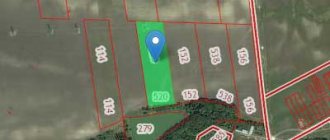
If land ownership has not been surveyed and cadastral work has not been carried out in relation to it, then it is recorded in the cadastre without designated boundaries. In order to determine the boundaries of the allotment, contact the specialists who carry out cadastral valuation work on your previously registered land.
Sometimes it is possible to change the status of registered or previously registered land to archival without filing applications when taking into account the rights to other objects formed from such property. This is also possible if land ownership is the property of the state or municipality before boundary work is carried out and the lease right to at least one formed plot of such objects is registered.
If you have a document for such an allotment, but there is no information about it in the cadastre, contact the competent authorities to enter it.
Land intended for gardening
Land plots that are used for gardening (SNP, SNT) are limited by the area of the plot and the house.
It is worth understanding that horticultural non-profit partnerships (NPP) and horticultural non-profit partnerships (SNT) have a slight difference. This difference is associated with the category of agricultural land and the category of allotments of settlements.
Lands of settlements are territories that belong to a village, town or village. Country real estate is also part of the city limits. Areas that have agricultural status are located tens of kilometers away. As a rule, such plots are “cut off from civilization.”
How to find out the status of a land plot
There is no need to visit the authorized authorities to find out what the status of the land tenure record is. Now this can be done using a computer connected to the Internet.
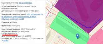
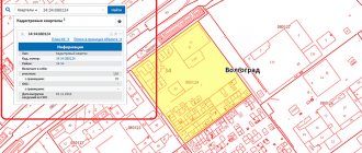
The official portal of Rosreestr https://pkk5.rosreestr.ru contains a public cadastral map that displays data regarding lands registered with the state cadastral register. The algorithm of actions is quite simple.
To obtain information about the land plot you are interested in, follow these steps:
- Using any browser, go to the website https://pkkrosreestr.ru;
- use the search bar to view land ownership information;
- the search is carried out based on the cadastral number of the plot, so do not change this option;
- Place the cursor on the input window and enter the unique number of the plot of interest according to the cadastre. When entered, possible options appear from the list of registered land holdings. Remember that in this case the numeric keypad should be used to move the map in arrow mode. To switch it to the required mode, press the NumLock key or use the keys that display letters;
- after you have completely entered the cadastral number, click the “Find” button;
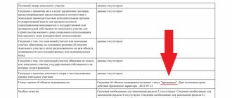
- after some time during which the search takes place (this process is displayed with a special icon), you will be presented with all available information about the plot of interest, where the required record is displayed with the status “Previously taken into account”.
Clarification of territory boundaries
Records in the cadastre about some previously registered land plots may contain insufficient information or be completely absent. If, in fact, a citizen has evidence that the land was in his use, but there is no data about this in the register, a repeat check is required to clarify the boundaries of the allotment. This is necessary when:
- there is no information about the territory in the Cadastre;
- the information contained in the passport is outdated, inaccurate or was received too long ago (15-20 years ago or older).
Why do you need to know the status of a land plot?
Any landowner can clarify what status the owned plot has. In January 2021, a new law will come into force, establishing the obligation not only to confirm the right to dispose, but to indicate the exact boundaries of the site when making transactions.
Today, a large number of previously recorded land holdings are not demarcated, so they do not have clearly defined boundaries. Without carrying out boundary work and transferring the plots to the number of registered ones, it will be impossible to make transactions with such lands.
Inaccurate determination of the boundaries of land plots can lead to the intentional or unintentional seizure of parts of neighboring lands, discrepancies in the actual dimensions of the plots and the data on the size reflected in the title documents.
In addition, if boundaries are not set accurately, there is a possibility of incorrect calculation of payments for the exploitation of land holdings.
How to remove temporary status from a site?
Read about the previously recorded status of the land plot here.
What is the temporary status of a land plot, read the link:
A new law that should determine the legal status of dachas and gardening partnerships
The ministry believes that summer residents should be divided into three categories : gardening partnerships, vegetable gardening and dacha non-profit partnerships . Cooperatives and partnerships that do not comply with this division (for example, non-profit partnerships or consumer cooperatives) will be required to reissue their constituent documents before January 1, 2027 . According to the project of the Ministry of Economy, the country real estate in question is divided into two types : garden house and dacha . A summer house will require a building permit , but a garden house will not. If real estate on a summer cottage was already built before the law came into force, then such an object will automatically be classified as a garden house.
We recommend reading: Car sales tax 2021
According to him, the government is considering a bill that will determine the legal status of gardening partnerships . The text of this draft was prepared by the Ministry of Economy. In fact, these are amendments to several existing codes at once - Land, Housing, Civil and Forestry. If the government and the President of Russia approve the document, the law will come into force on March 1, 2020.
How to change the status of a land plot to registered
This may be required if you are going to perform various actions with the owned land that give rise to legal consequences: alienate, donate, lease. Only if you have the status of a registered plot, you have the right to perform such actions and dispose of the land of your own free will.
To assign the status of a registered plot to an allotment, the following conditions must be met:
- the object is owned;
- land surveying work has been carried out in relation to the allotment;
- if the site is owned by the municipality, it must be leased.
After the specified conditions are met, the status of the land automatically changes to registered.
How to register a plot of land as your property
To register land ownership rights, visit the Rosreestr office or a multifunctional center, submit the necessary application, pay the state fee and submit the required documentation.
The cadastral registration procedure is the initial stage of claiming your rights to real estate. Thus, if your allotment is not registered, deal with this issue first.
Prepare a proper documentation package in advance, consisting of:
- document proving your identity. If you represent the interests of another person, you will need a notarized power of attorney;
- statements of intention to register ownership of a land plot;
- cadastral extract for land;
- a document on the transfer of ownership of land (for example, a purchase and sale agreement, donation, etc.);
- two copies of the payment document in relation to the state duty (original and copy).
The alienator of the plot will have to present his identification document and title documents for land ownership.
After collecting the required papers and, if necessary, performing additional activities (for example, land surveying), report to the authorized bodies to complete the procedure for registering rights to the site. Today, submitting documents is possible both directly through Rosreestr and through the MFC. Registration will cost the amount required by the state fee. Since the beginning of 2015, for citizens the cost of simplified registration is 350 rubles, regular registration – 2000 rubles. For organizations, the state duty is much larger and equal to 22,000 rubles.
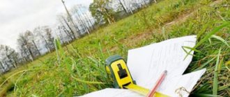
How to make a land survey
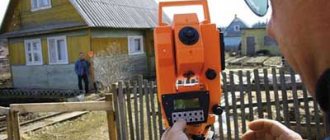
The execution of boundary work falls within the competence of cadastral engineers - specialists who have passed a qualification exam, which gives the right to engage in this type of activity. As a rule, the work of cadastral engineers occurs with the help of specialized organizations that facilitate geodesy in the territory.
To carry out land surveying work, contact the appropriate organization that carries out such activities.
Write an application and attach to it a set of necessary documents, consisting of:
- documents of title to the plot (various contracts, certificates of inheritance, etc.);
- technical documents (cadastral passport, certificate received from the BTI confirming the absence of buildings on this site, etc.);
- your general passport, but if you represent the interests of a legal entity, you will need constituent documents.
Find out the full list of documentation from the cadastral engineer when contacting the appropriate organization.
The process of land management work will not take much time. As a rule, cadastral engineers carry out such procedures within 10 – 14 days. At the same time, do not forget that at least a month before the start of the event, you must notify the owners of neighboring plots about this. Therefore, the land survey will be completed in approximately one and a half months (if everything is done correctly and the Rosreestr body does not return the documents for corrections).