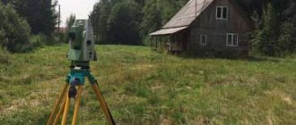
Accurate information about the boundaries of your land can be determined only after the surveying procedure .
Surveyors, using special instruments, will accurately determine the coordinates of the plot boundaries.
The procedure is preceded by the collection of documents, the conclusion of an agreement with a company or cadastral engineer and agreement with neighbors.
In this article we will look at how you can find out the boundaries of a land plot by address.
What is it and what is it for?
The boundary plan is the main document on the basis of which data on a land plot is entered into the State Real Estate Cadastre. The document is drawn up on the basis of a cadastral plan or a cadastral extract from the land plot. The land survey plan contains information about changes to the boundaries of the site, its parts and the site itself. The data entered into the MP is needed to register the land plot for cadastral registration.
The exact description of the form and composition of the document on the formation of a landowner is specified in the order of the Ministry of Economic Development No. 921 dated December 8, 2015.
The boundary plan can be drawn up in both paper and electronic forms. For the electronic form, an electronic signature of the cadastral engineer is also required.
The MP itself is required to obtain a cadastral passport. A cadastral passport is a mandatory document when making any transactions with a land plot, including:
- donation;
- purchase and sale;
- exchange;
- will.
Reasons for creating or updating a survey plan:
- creation of land plots from state or municipal lands;
- combining several neighboring areas;
- allocation of a plot of land in common ownership;
- section of the site;
- detection and correction of errors in cadastral registration;
- redistribution of plots.
If an MP is created on the basis of a merger of neighboring plots, then an “Act of Approval” is additionally attached to it, where all interested parties are required to sign.
Land surveying is carried out to establish its boundaries on the ground. Land surveying is carried out if the boundaries of a land plot are not established (including if information about its boundaries is not in the Unified State Register of Real Estate or does not meet the legal requirements for describing their location), when citizens receive new land plots, purchase and sale, exchange, donation of all or part of the land plot, etc.
It is impossible to carry out land surveying work on your own, since for this you need to have a license to carry out geodetic and cartographic activities. To carry out land surveying it is necessary to carry out the following actions. 1. It is necessary to prepare documents for the land plot. For this you will need: - a certificate of ownership of the land. This may also be an administrative resolution on the provision of a land plot, a notarized certificate of the right to inheritance, a court decision, a purchase and sale agreement, exchange, donation; — passport of the legal owner of the land plot (and its copy); — power of attorney for a representative (if a representative will act on behalf of the owner). 2. Conclusion of a contract for land surveying work. A contract for carrying out cadastral work is concluded with a cadastral engineer (individual entrepreneur) who is a member of a self-regulatory organization of cadastral engineers, or a specialized organization that has a cadastral engineer on staff. The contract for the performance of cadastral works may provide for the obligation of the cadastral engineer to place the boundary plan prepared by him in the electronic storage. 3. Carrying out cadastral work on land surveying Cadastral survey work is carried out by a cadastral engineer and usually includes a set of works:
- collection and study of information about the land plot, documents provided by you for the land, available geodetic data on the plot, as well as addresses of neighboring (adjacent to yours) land plots;
- preparation of a survey project (or technical project), which must correspond to the survey assignment;
- mandatory notification of neighbors on the site (that is, persons whose rights may be affected by land surveying);
- visiting the site and determining the boundaries of the site on the ground. As a rule, the boundaries of a site are determined by actual use or from the words of the owner. In this case, an act of coordination of the boundaries of the site with the neighbors must be obtained;
- geodetic survey of the site and determination of the coordinates of boundary markers;
- accurate determination of the area of the land plot;
- drawing of the land plot with all its boundaries;
- preparation of the Land Survey Plan.
4. Making a boundary plan
The boundary plan is prepared in the form of an electronic document and signed with an enhanced qualified electronic signature of the cadastral engineer who prepared such a plan. If this is provided for in the contract, the boundary plan can also be prepared in the form of a paper document, which is also certified by the signature and seal of the cadastral engineer who prepared it. 5. Submission of documents to Rosreestr for cadastral registration of a land plot and registration of ownership. If the boundary plan is placed in temporary storage in an electronic storage, then when submitting the application and the documents attached to it, you have the right to indicate in the application the identifying number of the boundary plan. In this case, its presentation will not be required. The application and necessary documents can be submitted to Rosreestr in one of the following ways:
- directly to the Rosreestr branch or through the MFC (regardless of the location of the property according to the list of divisions that carry out reception on an extraterritorial basis posted on the Rosreestr website) or to an authorized person of Rosreestr during on-site reception;
- by postal item with a declared value upon forwarding, an inventory of the contents and a notification of delivery (in this case, in particular, the authenticity of the signature on the application must be certified by a notary);
- in the form of electronic documents via the Internet, for example, through the official website of Rosreestr.
It is necessary to pay a state fee for state registration of property rights. Submission of a document confirming payment of the state fee along with the application is not required. The applicant has the right to do this on his own initiative. However, if there is no information about the payment of the state duty in the State Information System on state and municipal payments, after five days from the date of filing the application, the rights registration authority returns the application and the documents attached to it without consideration. If at the time of submission of the application the state duty has not been paid, the applicant is issued or sent information containing a unique payment identifier (unique accrual identifier) necessary to confirm the fact of payment for a specific service for payment of the state duty, indicating the date by which it must be paid. 6. Receipt of documents after cadastral registration and state registration The completed state registration is certified by an extract from the Unified State Register of Real Estate, which can be sent to you in electronic form.
What does a land surveying project and its contents look like?
A standard boundary plan consists of two parts: text and graphic. Each part is also divided into sections. The paper version of the boundary plan is left on several sheets of A-4 format.
The graphic part is allowed to be compiled on larger format sheets. The MP in paper form is drawn up in at least two copies.
Text part
The text part is written on several sheets. If all the information is not reduced on one sheet, then you can write on the reverse side, but “Landing plan” must be written on each page. Continuous numbering of document pages is required. The text part includes:
- general information, as well as the immediate purpose of cadastral work;
- initial data, a list of documents that were used during the work;
- information about geodetic survey;
- information about the land plot and its parts, as well as about the real estate that is located on it;
- the listed work performed, how exactly the coordinates of characteristic points were determined, the boundaries of the site, measurement accuracy, area;
- a separate section for modified areas;
- section for new sites;
- possibility of access to the described area;
- conclusion of a cadastral engineer;
- act of approval.
If the site is just being formed, then the address, category of land, type of use, data from the Unified State Register, and cadastral number of the property are indicated.
The grafical part
The graphic part is also mandatory and includes several subsections:
- designation scheme for geodetic constructions;
- drawing of the site itself;
- site layout diagram;
- description of the outlines for the nodal points of the memory.
Depending on the type of land surveying plan, the mandatory and additional subsections vary.
Here's what a sample land plot plan looks like as an example:
Kinds
According to the existing Land Legislation, there are 7 types of land survey plans. These include:
- A type that specifies the boundaries of the site and its area. Necessary if the cadastral registration system does not have enough information about a specific land plot.
- A plan for clarifying boundaries when allocating land from state or municipal lands.
- A plan to provide information about a site that is separated from common shared ownership.
- Plan after combining several sections into one (multi-circuit).
- Information on the redistribution of plot boundaries.
- Plan for correcting cadastral errors and inaccuracies.
- A plan reflecting information on the results of dividing the site into several.
Each type of MP has its own mandatory information to be entered.
In what cases is it necessary
There are several reasons why it is necessary to know the exact boundaries of a property. Sometimes the owner or owner of the land is not satisfied with the information about the actual boundaries . That is, those that were installed “along the boundary”. They may not be precise, unlike legal boundaries.
With the help of precision instruments, a cadastral engineer can establish boundaries with an accuracy of up to a centimeter . The reason for a specialist’s visit may be the cancellation of the results of a previous survey or the merging of areas. Let's consider several cases.
Lack of understanding of real boundaries
One of the reasons for land surveying is the owner’s desire to know exactly where the boundaries of his property lie .
This mainly applies to plots located on the lands of SNT (horticultural non-profit partnerships).
Most of them were allocated for use back in Soviet times.
The measurements were inaccurate and, often, the owners themselves did not really know where the property line was.
Despite the fact that land surveying is an expensive procedure, many have tried to clarify the boundaries by calling a cadastral engineer.
Another example is installing a fence around the entire perimeter of the site . Since the fence is installed for several decades, sometimes for a lifetime, it is advisable not to doubt where it will go.
Making a deal
A change in land ownership is also a sufficient reason to determine the coordinates of the boundaries of your plot.
From a legal point of view, an undemarcated area can be :
- sell;
- give;
- bequeath
In general, dispose of your property in full (if you have taken ownership). The hype that is fueled in the media about the impossibility of making land transactions is artificial.
As a result of the execution of transactions, problems may arise that will prevent the transaction from being completed without land surveying .
For example, if the sale is formalized with the help of a notary who requests cadastral documents for the land. Or an error was discovered in the cadastral documents - the boundaries are crossed.
Areas where land surveying has been carried out are in greater demand than those where boundaries have not been established. The buyer wants to know exactly the area of the property he is buying.
Lack of agreement with neighbors
Disputes with neighbors over land boundaries are one of the most common reasons for starting land surveying. The procedure itself will not dot all the i’s. First of all, there must be a competent approach here. Therefore, it is important to find an experienced cadastral engineer.
Interaction with neighbors regarding boundaries can have 2 stages: negotiations and litigation . It is best to stop at the first one and resolve conflicts peacefully through mutual concessions. To coordinate and sign the relevant act, you will need to call your neighbors.
When relations with neighbors are cool, it is better to inform about the arrival of the cadastral engineer in writing, using a notice.
The notification is sent twice. If they do not come on the appointed day and do not inform about the reasons for their absence, then the boundaries are considered agreed upon.
In controversial issues, the problem of the boundary between plots is decided by the court.
Often, an independent examination is appointed .
The act of coordination with neighbors is part of the boundary plan.
Clarification of the amount of land tax
The tax base for land tax is the cadastral value of the plot. It depends on many factors, including area. Errors may occur when calculating taxes.
This happens especially often with areas that are registered in the cadastral register “without defining boundaries.” When they are clarified, the area may change upward.
In this case, it is necessary to conclude an agreement with one of the companies that are engaged in land surveying and invite a cadastral engineer. He will accurately calculate the area of the plot, and, taking into account all factors, the cadastral value. The updated data is submitted not only to the state cadastre, but also to the tax service.
Difference from geodesy
Geodesy and land surveying are fundamentally different, but interconnected procedures for clarifying the boundaries of a site.
- Geodesy involves topographic surveying of the area, and at the same time the customer receives a completed topographic map on a certain scale.
- Land surveying has a clear connection to the area by determining the shape of the site, its boundaries, area, as well as the mandatory clarification of information on real estate located on the site.
After the surveying procedure, all received data is registered in the Register. Geodesy does not assume this. In geodetic work, all information is of a purely general nature.
Difference with privatization
These are different procedures.
- The land surveying process involves clarifying the boundaries of the site and creating a drawing for a specific site with all the necessary data entered into the land survey plan.
- Privatization is the transfer of state or other lands into ownership free of charge with subsequent registration of the owner’s rights.
It is important to understand that surveying a plot of land does not make a person its owner. To do this, you need to collect and submit a certain list of documents, among which will be a land survey plan.
Step-by-step instructions: where and how can I get MP?
To obtain a Landmark Plan, which fully complies with all legal requirements, you must contact specialized organizations, which is a paid service. The cost of land surveying depends on the area of the land plot.
Documents for registration
To obtain a land survey plan, you must provide the following documents:
- a document certifying the rights to this land plot;
- certificate of ownership of the site;
- a copy of the site master plan;
- cadastral passport of the land plot;
- owner's civil passport.
If representatives act in the interests of the copyright holder, then you need to have a notarized power of attorney, as well as the passport of the representative himself. If the plot is in shared ownership - an agreement left and signed by the participants in shared ownership.
State duty for production
To formulate a plan, you must contact either the Department of Architecture and Urban Planning or private organizations.
All issues related to payment of the state duty for registering agricultural land plots for cadastral registration are stipulated in Art. 333.33 Tax Code of the Russian Federation:
- when registering 1 subject of property - for individuals 2000 rubles, for organizations - 22 thousand;
- for memory – 350 rubles;
- to make changes to the Unified State Register – 350 rubles.
There are categories of citizens exempt from paying state duty:
- low-income people according to the provisions of the Housing Code;
- federal, municipal and regional authorities.
All others must pay the state duty in full.
In addition to the actual fees, it is necessary to pay for the work of the cadastral engineer. The cost depends on the area of the site and differs depending on the region and the specific organization that performs the survey.
Conclusion of an agreement
The contract for the work must be concluded with a licensed geodetic firm. The contract must specify the terms, as well as the cost of the work performed and the payment procedure between the parties.
The subject of the contract is a specific list and scope of boundary measures to be carried out, which regulatory act will guide the engineer when carrying out the work.
Coordination with neighbors
This is another essential part of preparing a plan. It is necessary to leave a document in which the area and boundaries of the copyright holder's plot will be marked with a red line on the general plan sketch.
Each owner of a neighboring plot must personally sign this document. If there are neighbors who refuse to sign the act, you will have to go to court.
Disengagement procedure
The demarcation procedure is carried out between the owners of the same plot, between a group of owners, between neighbors, when overlapping boundaries arise. After the demarcation procedure is completed, a separate document is generated for each individual section.
Demarcation of land for housing construction makes it possible for apartment owners to secure rights to the land under the house.
Entering information into Rosreestr
In addition to the received cadastral plan, the following documents will be needed to register the land plot:
- confirmation of ownership rights;
- foundation documents: purchase and sale agreement, donation, lease, will;
- original geodetic plan;
- the original power of attorney, if the registration is carried out by an authorized person;
- document from the Guardianship authorities, if the owner is a minor.
Before registering the cadastral plan, you need to pay a state fee in the amount of 200 rubles for citizens and 600 rubles. for companies.
At Rosreestr, submit the entire package of documents to an authorized employee and receive a receipt. If all the documents are numbered, then the land plot will be registered and assigned a cadastral number. If it is necessary to make changes, the registration may take from two to 6 months.
Land survey plan
1. Identity document of the applicant.
2. Notarized power of attorney (if the applicant’s representative applied for the work to be performed).
3. Documents required for preparing a boundary plan (one or more documents):
— urban planning zoning documents (extract from ISOGD);
— documentation on territory planning (territory planning projects, territory surveying projects);
— documents defining (determining), in accordance with the legislation of the Russian Federation, the location of the boundaries of the land plot (land plots) upon its formation;
— diagrams of the location of a land plot on the cadastral plan of the territory, decisions providing for the approval of the diagram of the location of a land plot or land plots on the cadastral plan of the territory;
— decisions on preliminary approval of the provision of land plots;
— decision to seize a land plot and (or) a property located on it for state or municipal needs);
- certificate of ownership of land containing a drawing of the land plot;
— land management documentation stored in the state fund of data obtained as a result of land management;
— projects for the organization and development of territories of horticultural, market gardening or dacha non-profit associations of citizens approved in the established manner;
— decisions on the provision of land plots, other documents on rights to land plots;
— judicial acts that have entered into legal force.
4. Title and title documents (one or more documents):
— extract from the Unified State Register of Land Registers for the land plot;
— extracts from the Unified State Register of Real Estate for real estate located within the boundaries of the land plot;
— certificate of right to inheritance;
— purchase and sale agreement/donation agreement.
5. Organization registration card (for legal entities).
The duration of the service does not exceed:
— 10 working days for the first stage of work and 5 working days for the second stage of work from the date of payment of funds for the boundary plan of a land plot intended for individual housing construction, personal farming, gardening, vegetable gardening, placement of an individual garage.
— 30 working days from the date of payment of funds for other boundary plans.
Information about receipt of payment to the bank account of the Regional BTI is posted on the main page of the website in the “Checking online application” section
https://kubbti.ru/status .
How to watch?
There are 2 ways to view the land survey plan for the land plot of interest.
By the address
If you need to look at the plan of a land plot, knowing only its address, just go to the website of the Public Cadastral Map https://egrp365.ru/map/. Then the algorithm of actions is simple:
- enter the address in the window located in the upper right corner and click “Find”;
- wait a while for loading.
As a result, a window will open indicating the cadastral number of the land plot, land category, area, as well as the fact of the procedure. If you left-click on the selected area on the map, you can get all the information about this memory.
How to clarify boundaries if there is a cadastral number?
On the same website it is possible to enter the cadastral number and then the system will provide a land survey plan. The window for entering the cadastral number is located above the window with the address. There is also a developed program specifically for smartphone owners.
Land surveying is a necessary procedure for accurately determining boundaries and resolving all disputes. Without this document, you cannot perform any action with real estate, including donation and sale. The land surveying plan must strictly comply with legal requirements and have both text and graphic parts with all data.
We tried to write the best article. If you liked it, please share it with your friends or leave a comment below. Thank you! Great article 8
How to check boundaries?
The boundaries of land plots are usually considered to be the lines of contact of the plot with other territories. The easiest way to determine boundaries is using the Public Cadastral Map (PCC) .
Its creation and updating is carried out by Rosreestr specialists, which guarantees that you receive up-to-date information. If necessary, you can save the found data in Excel. Users can see what the area they are interested in looks like, with the boundaries highlighted on one of the proposed maps:
- Google Maps.
Allows you not only to study a satellite map, plan or diagram on which the boundaries of the land plot are marked, but also to see a panoramic view of the area (read about what a cadastral plan of a land plot looks like here, about what a cadastral plan of a land plot is, where and how get it, find out here). The main advantage of Google Maps is the ability to take a virtual trip through the territory of any region. - Initially, this service stored information about city organizations and the buildings in which they are located. Later, 2GIS connected to the Rosreestr program and began to provide a schematic map of territories. This resource is created by users who upload photographs of sites into it. You won't be able to find cadastral markers here, but you can see photographs of the plots. This is especially useful for those who are thinking about buying land plots (read about who can buy land at cadastral value from the administration and the state and how to do it here).
- Yandex maps. They differ from PKK in a more comfortable scaling tool and the presence of not only diagrams of territories, including borders, but also their satellite images.
All of the services listed above allow you to find out the boundaries of the memory. The difference between them is only in the display of information, so everyone can independently choose which card to use.
To determine the boundaries of the allotment according to the PKK, you need to perform the following steps:
- Follow the link https://egrp365.ru/map/. The most current data is displayed here.
- In the upper right corner of the page there is a window where the user can select the desired card.
- In the menu, you can check the box next to the item “Show cadastral boundaries of plots”. In this case, a grid of territories will be immediately superimposed on the PKK.
- Oh, the user can select the criteria for displaying information:
- by cadastral value (find out about determining the cadastral value of a land plot in this material);
- by form of ownership;
- by category;
- on territorial zoning, etc.
- After setting the parameters, you need to enter the cadastral number in the empty line and click the “Search” button.
- The requested area will appear on the map. If you click on it with the left mouse button, you can find out such data as the area of the plot, its form of ownership, etc.