What is it and what is it for?
The boundary plan is the main document on the basis of which data on a land plot is entered into the State Real Estate Cadastre. The document is drawn up on the basis of a cadastral plan or a cadastral extract from the land plot. The land survey plan contains information about changes to the boundaries of the site, its parts and the site itself. The data entered into the MP is needed to register the land plot for cadastral registration.
The exact description of the form and composition of the document on the formation of a landowner is specified in the order of the Ministry of Economic Development No. 921 dated December 8, 2015.
The boundary plan can be drawn up in both paper and electronic forms. For the electronic form, an electronic signature of the cadastral engineer is also required.
The MP itself is required to obtain a cadastral passport. A cadastral passport is a mandatory document when making any transactions with a land plot, including:
- donation;
- purchase and sale;
- exchange;
- will.
Reasons for creating or updating a survey plan:
- creation of land plots from state or municipal lands;
- combining several neighboring areas;
- allocation of a plot of land in common ownership;
- section of the site;
- detection and correction of errors in cadastral registration;
- redistribution of plots.
If an MP is created on the basis of a merger of neighboring plots, then an “Act of Approval” is additionally attached to it, where all interested parties are required to sign.
What does a land surveying project and its contents look like?
A standard boundary plan consists of two parts: text and graphic. Each part is also divided into sections. The paper version of the boundary plan is left on several sheets of A-4 format.
The graphic part is allowed to be compiled on larger format sheets. The MP in paper form is drawn up in at least two copies.
Text part
The text part is written on several sheets. If all the information is not reduced on one sheet, then you can write on the reverse side, but “Landing plan” must be written on each page. Continuous numbering of document pages is required. The text part includes:
- general information, as well as the immediate purpose of cadastral work;
- initial data, a list of documents that were used during the work;
- information about geodetic survey;
- information about the land plot and its parts, as well as about the real estate that is located on it;
- the listed work performed, how exactly the coordinates of characteristic points were determined, the boundaries of the site, measurement accuracy, area;
- a separate section for modified areas;
- section for new sites;
- possibility of access to the described area;
- conclusion of a cadastral engineer;
- act of approval.
If the site is just being formed, then the address, category of land, type of use, data from the Unified State Register, and cadastral number of the property are indicated.
The grafical part
The graphic part is also mandatory and includes several subsections:
- designation scheme for geodetic constructions;
- drawing of the site itself;
- site layout diagram;
- description of the outlines for the nodal points of the memory.
Depending on the type of land surveying plan, the mandatory and additional subsections vary.
Here's what a sample land plot plan looks like as an example:
Layout of the land plot.
A land plot location diagram (LPL) is a document that represents a plan of the boundaries of the created plot or redistributed territories. It is approved by authorized officials and is a graphic appendix to the order of the body responsible for the distribution of land resources. The diagram contains a description of the location of the site. It determines the specific location of the plot on the ground (coordinates), as well as the area and configuration of the boundaries of the allocated territory.
Kinds
According to the existing Land Legislation, there are 7 types of land survey plans. These include:
- A type that specifies the boundaries of the site and its area. Necessary if the cadastral registration system does not have enough information about a specific land plot.
- A plan for clarifying boundaries when allocating land from state or municipal lands.
- A plan to provide information about a site that is separated from common shared ownership.
- Plan after combining several sections into one (multi-circuit).
- Information on the redistribution of plot boundaries.
- Plan for correcting cadastral errors and inaccuracies.
- A plan reflecting information on the results of dividing the site into several.
Each type of MP has its own mandatory information to be entered.
Technical plan for renting premises.
When it becomes necessary to transfer an entire building or its individual parts for long-term lease, there is a need to draw up a certain list of documents in order to prepare and register the relevant agreement.
After studying the submitted documents, in order to carry out cadastral work to allocate part of the real estate under a lease agreement, the following data on real estate objects (or parts thereof) that are transferred for long-term lease are entered into the technical plan:
- area of the premises (building, structure);
- indication of the floor where the rental property is located;
- numbers of premises, rooms and other long-term rental objects;
- plan of the part of the property for long-term lease.
The information is filled in based on the data specified in the documents provided by the lessor for the preparation of the technical plan.
Only after a thorough check of the technical passport, the registration authorities issue an extract from Rosreestr for the property, in which the parts to be transferred for long-term lease will be identified.
Difference from geodesy
Geodesy and land surveying are fundamentally different, but interconnected procedures for clarifying the boundaries of a site.
- Geodesy involves topographic surveying of the area, and at the same time the customer receives a completed topographic map on a certain scale.
- Land surveying has a clear connection to the area by determining the shape of the site, its boundaries, area, as well as the mandatory clarification of information on real estate located on the site.
After the surveying procedure, all received data is registered in the Register. Geodesy does not assume this. In geodetic work, all information is of a purely general nature.
Receipt
Where to get it
The boundary plan is prepared by a cadastral engineer based on the results of the survey. You can order the production of MP from any certified cadastral engineer, regardless of whether he works as an individual entrepreneur or is a representative of a geodetic company.
The current list of certified engineers can be viewed on the official website of Rosreestr.
Documentation
Along with the application for land surveying, the owner of the land plot must also provide :
- Your civil passport;
- Title documents for the site;
- Documents confirming the legality of obtaining the plot: resolution of the local administration on the allocation of the plot, act of purchase and sale, certificate of entry into the right of inheritance, etc.;
- Cadastral extract from the BTI in form B-1;
- Documents from the BTI about buildings located on the site;
- Allotment plan;
- List of owners of neighboring plots (if they are known to the applicant).
Difference with privatization
These are different procedures.
- The land surveying process involves clarifying the boundaries of the site and creating a drawing for a specific site with all the necessary data entered into the land survey plan.
- Privatization is the transfer of state or other lands into ownership free of charge with subsequent registration of the owner’s rights.
It is important to understand that surveying a plot of land does not make a person its owner. To do this, you need to collect and submit a certain list of documents, among which will be a land survey plan.
Design of residential, garden houses, auxiliary buildings and structures:
Technical plan, garden house
- Engineering and geodetic surveys to coordinate the building/structure within the boundaries of the land plot;
- Internal measurement work at a capital construction site;
- Preparation of a declaration on a capital construction project;
- Preparation of a technical description for a capital construction project (if necessary);
- Preparation of a technical plan for a capital construction project.
Result: Technical plan for an individual (garden/country) house.
Turnaround time:
Up to 10 days
Service cost:
From 19,000 rub.
Step-by-step instructions: where and how can I get MP?
To obtain a Landmark Plan, which fully complies with all legal requirements, you must contact specialized organizations, which is a paid service. The cost of land surveying depends on the area of the land plot.
Documents for registration
To obtain a land survey plan, you must provide the following documents:
- a document certifying the rights to this land plot;
- certificate of ownership of the site;
- a copy of the site master plan;
- cadastral passport of the land plot;
- owner's civil passport.
If representatives act in the interests of the copyright holder, then you need to have a notarized power of attorney, as well as the passport of the representative himself. If the plot is in shared ownership - an agreement left and signed by the participants in shared ownership.
State duty for production
To formulate a plan, you must contact either the Department of Architecture and Urban Planning or private organizations.
All issues related to payment of the state duty for registering agricultural land plots for cadastral registration are stipulated in Art. 333.33 Tax Code of the Russian Federation:
- when registering 1 subject of property - for individuals 2000 rubles, for organizations - 22 thousand;
- for memory – 350 rubles;
- to make changes to the Unified State Register – 350 rubles.
There are categories of citizens exempt from paying state duty:
- low-income people according to the provisions of the Housing Code;
- federal, municipal and regional authorities.
All others must pay the state duty in full.
In addition to the actual fees, it is necessary to pay for the work of the cadastral engineer. The cost depends on the area of the site and differs depending on the region and the specific organization that performs the survey.
Conclusion of an agreement
The contract for the work must be concluded with a licensed geodetic firm. The contract must specify the terms, as well as the cost of the work performed and the payment procedure between the parties.
The subject of the contract is a specific list and scope of boundary measures to be carried out, which regulatory act will guide the engineer when carrying out the work.
Coordination with neighbors
This is another essential part of preparing a plan. It is necessary to leave a document in which the area and boundaries of the copyright holder's plot will be marked with a red line on the general plan sketch.
Each owner of a neighboring plot must personally sign this document. If there are neighbors who refuse to sign the act, you will have to go to court.
Disengagement procedure
The demarcation procedure is carried out between the owners of the same plot, between a group of owners, between neighbors, when overlapping boundaries arise. After the demarcation procedure is completed, a separate document is generated for each individual section.
Demarcation of land for housing construction makes it possible for apartment owners to secure rights to the land under the house.
Entering information into Rosreestr
In addition to the received cadastral plan, the following documents will be needed to register the land plot:
- confirmation of ownership rights;
- foundation documents: purchase and sale agreement, donation, lease, will;
- original geodetic plan;
- the original power of attorney, if the registration is carried out by an authorized person;
- document from the Guardianship authorities, if the owner is a minor.
Before registering the cadastral plan, you need to pay a state fee in the amount of 200 rubles for citizens and 600 rubles. for companies.
At Rosreestr, submit the entire package of documents to an authorized employee and receive a receipt. If all the documents are numbered, then the land plot will be registered and assigned a cadastral number. If it is necessary to make changes, the registration may take from two to 6 months.
Construction notice.
All that is needed for construction today is simply to prepare a notice of planned construction and send it to the local administration.
Composition of the service
- Analysis of your existing documents;
- Preparation of notice of planned construction or planned completion of construction;
Why is it better to contact us?
Of course, you can fill out a notice of planned construction yourself, without resorting to the services of a specialized organization.
But, as a rule, doing this correctly on your own is not easy and not everyone succeeds. Our specialists:
They will analyze your existing house project (if any) or listen to your wishes (if there is no project) and give their recommendations on the correct placement of the building on the land plot, draw up statements of the main technical indicators of the planned construction, prepare a description of the construction project in accordance with the requirements of technical regulations in construction and taking into account the requirements of the land use and development regulations of the municipality within the boundaries of which the land plot on which construction is expected to take place is located;
They will help you select and prepare the necessary package of documents for submitting a notification to the administration;
Prepare a notice of planned construction or completion of construction in accordance with the requirements of laws and technical regulations;
How to watch?
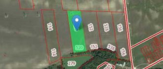
There are 2 ways to view the land survey plan for the land plot of interest.
By the address
If you need to look at the plan of a land plot, knowing only its address, just go to the website of the Public Cadastral Map https://egrp365.ru/map/. Then the algorithm of actions is simple:
- enter the address in the window located in the upper right corner and click “Find”;
- wait a while for loading.
As a result, a window will open indicating the cadastral number of the land plot, land category, area, as well as the fact of the procedure. If you left-click on the selected area on the map, you can get all the information about this memory.
How to clarify boundaries if there is a cadastral number?
On the same website it is possible to enter the cadastral number and then the system will provide a land survey plan. The window for entering the cadastral number is located above the window with the address. There is also a developed program specifically for smartphone owners.
Land surveying is a necessary procedure for accurately determining boundaries and resolving all disputes. Without this document, you cannot perform any action with real estate, including donation and sale. The land surveying plan must strictly comply with legal requirements and have both text and graphic parts with all data.
We tried to write the best article. If you liked it, please share it with your friends or leave a comment below. Thank you! Great article 8
Linking the building to the land plot.
Stages of work:
- Studying the source data
- Shooting of the allotment indicating the existing structures;
- Preparation of a technical plan in the form of an electronic file with a certified signature of a specialized specialist (linking a building to a land plot without a technical plan is impossible);
- Collection and preparation of a complete package of documents;
- Drawing up an application for recording amendments to the cadastre;
- Submission of documentation to Rosreestr or through the MFC in a suitable manner
Internal measurements of buildings and premises, drawing up floor plans and explications, technical description of the facility.