When registered with the state cadastral register, land plots are endowed with a number of characteristics, both basic and additional. All information about the allotment in the Unified State Register of Real Estate (hereinafter referred to as “USRN”) allows you to identify it as a unique thing, as well as determine its functional purpose. In addition to the characteristics that are obvious to everyone (cadastral number, area, address, etc.), land plots also have a category of land and type of permitted use (and this is not the same thing). However, for many it remains a mystery that a land plot may also have a status. In this article we will explain in detail what the status of a land plot means - temporary, registered, cancelled.
What is the status of a land plot
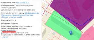
To begin with, it is worth explaining what kind of animal this is, the status of the land plot. In fact, it is not the land plot itself that has the same status (temporary, registered, cancelled), but a record about it in the Unified State Register of Real Estate, i.e. information about a real estate property can have the following status: “temporary”, “recorded” (or “previously recorded”) and “cancelled”. Ask how to check this very status of a land plot? Yes, it’s very simple, online and completely free! check the status of a land plot using open sources, such as the public cadastral map and the Rosreestr portal; you only need to enter the cadastral number.
Also, the status of information about a real estate property is indicated in an extract from the Unified State Register of Real Estate for such an object.
Arbitrage practice
With the development of the sphere of private land ownership rights, the issue of acquiring rights to plots is extremely relevant.
Thus, according to statistics for 2021, land conflicts account for about 3% of the total number of civil cases considered by judicial institutions.
Video: pre-registration for an appointment with Rosreestr
In addition, cases regarding complaints about inaction or unlawful actions of state and municipal employees are often considered.
Based on the results of cases considered in the appellate court, the stability of court decisions on land proceedings is about 90%.
We also note that until recently, court cases were dominated by boundary conflicts, land use procedures, and questions regarding the use of agricultural land.
How many meters from the fence you can build a house according to the law in 2021, find out from the article: how many meters from the fence you can build a house.
What documents are needed to register a child in the owner’s apartment?
What documents are needed to register a child in an apartment?
However, today the main ones are restrictions on the rights to use land, carrying out the cadastral registration procedure to place previously registered plots on full cadastral registration.
All legal claims regarding the rights and use of land plots are filed with the courts at the location of the site according to the rules of exclusive jurisdiction.
So, we have examined in detail important issues regarding the procedure for registering previously registered lands in the state cadastre, what documents are required for this and in what time frame the process is carried out.
It must be remembered that when submitting documentation and applications, as well as when receiving a ready-made cadastral passport, you must carefully check them for errors and inconsistencies.
Related topics:
- Coordinates of the boundaries of the land plot Turning points of the boundaries of the land plot: accuracy and error of surveying This is the minimum number of possible turning points, ...
- How to privatize a garden plot? Dacha amnesty and its duration You can privatize a plot of land that is already in use for free. The law was passed...
- Find out who owns the site Methods of collecting information Rosreestr Federal Law of July 21, 1997 No. 122-F3 and Art.…
What does the temporary status of a land plot mean?
As we have already explained, it is not the land plot itself that has the “temporary” status, but the entry about it in the Unified State Register of Real Estate. Let's figure out why they are still temporary. So, according to the law, the full “circle” of legalizing a land plot is the procedure for registering it in the cadastral register and registering ownership of it. Yes, formally these are two autonomous procedures; previously they were carried out even by different organizations: the cadastral and registration chambers (remember those?). Those. The cadastral chamber entered into the register information directly about the real estate itself, and the registration chamber about persons having real rights to such objects. After the merger of these two structures into one, Rosreestr, and the emergence of a single database (USRN), these processes are carried out simultaneously and there is no longer a need to submit several applications in different places. However, the law provides for exceptional cases when it is possible to register a property for cadastral registration without subsequent registration of rights to it. And just in the case when a land plot is registered in the cadastral register without subsequent registration of ownership rights to it, the status of the entry about such a plot in the Unified State Register will be “temporary”.
The status of the object will be “temporary” in Rosreestr until the procedure for registering ownership rights to such a land plot is carried out. At the same time, do not forget that if the land plot was registered in the cadastral register before January 1, 2021, then the rights to it must be registered before March 1, 2022.
Previously accounted area - what is it?
The legislator, on the basis of the Federal Law “On Cadastral Activities”, established that land plots are considered previously registered if the right to them was registered by the owner before the entry into force of this legal act.
In essence, these are areas registered according to the old rules that require changes to their documentation. The cadastral chamber reflects information about such plots, but only in the volume and content that was known when the plot was transferred to the owner. For example, the database will contain the following information:
- cadastral number;
- date of entering information into the database;
- address of the land plot;
- site category;
- purpose of the allotment;
- square;
- cadastral value;
- information about the citizen to whom the plot was issued.
Previously, another law was in force, “On the State Land Cadastre”. It contained its own procedure for recording information about land and its own rules for cadastral registration. It is precisely those areas that were registered according to the rules of this norm that will be considered previously taken into account.
Link to document: “On cadastral activities”
What does the canceled status of a land plot mean?
We smoothly moved on to clarify the next status of the entry on a land plot in the Unified State Register of Real Estate, namely, what the “cancelled” status of a land plot means. A record of a land plot acquires a canceled status if the registration of ownership (or other real right) to such a property is not completed on time. In other words, if the plot was registered in the cadastral register, i.e. its individual characteristics are included in the Unified State Register, but for some reason the registration of the right to it was not carried out, then after March 1, 2022, the entry in the Unified State Register about such a plot will automatically acquire the status “cancelled”. Accordingly, the cadastral registration procedure will have to be completed again.
At the moment, the status “cancelled” can be found in land plots that did not have time to register within 5 years after registration in the cadastral register.
In fact, all the information that gets into the Unified State Register of Real Estate does not disappear without a trace; in fact, it remains there forever, but don’t expect any concessions. By acquiring the “cancelled” status, the information falls into a certain buffer, which will not allow any actions to be carried out with such a property. Therefore, we urge you to be vigilant, if the seller points his finger at the extract from the Unified State Register of Real Estate (the title document, for a moment) for the land plot and tells you that everything is fine, but there the status of the record is “canceled”, you should know that this is either dishonest or absolutely incompetent seller. You will not be able to register a single action (including a transaction) with such a property; you will have to fork out extra money for the cadastral registration procedure and spend a lot more time.
By the way, you can quickly find a trusted cadastral engineer in your region using the online catalog of cadastral engineers; this resource will allow you to save time and nerves when choosing and checking the contractor.
What does the status of deregistration of a site mean?
It is not always necessary to register land; sometimes you need to do the opposite procedure. Deregistration of a previously registered plot of land occurs when there is a change in the boundaries of the plot or its division between the owners. In most cases, it is necessary to resort to the help of the court, since from a legislative point of view there is no established procedure for resolving such issues. You can do without a judicial authority in several cases.
- It is planned to carry out a division between persons possessing certificates of ownership of this plot. It is only necessary to make the actual division.
- Previously listed property information was temporary.
- Data about the land was contained in the registration authorities, but registration of rights was not carried out for 2 years.
In this case, you will need an application in the prescribed form, which indicates the owner’s request to deregister his property, and a document confirming the owner’s rights.
REFERENCE! The application can be submitted in person or electronically. If the decision of the government body is not positive, you should go to court.
The owner of the land area will receive a refusal if:
- the property is not registered in the Land Registry;
- the set of documents does not meet the requirements of the authorized body;
- 3 months were given to correct the documents, but the results were not presented;
The refusal is made in writing and handed over to the owner, who then defends his interests in court.
In practice, different situations and other solutions are possible. For example, a citizen is the legal owner of a house, but the document confirming his rights to the land has been lost. At the Cadastre authorities, the owner was refused a duplicate document confirming his full rights, since experts claimed that there was no information and the site had not previously been taken into account. During the Cadastre proceedings, a cadastral error was recognized, it was corrected, and information about the land was removed from the State Register database.
When going to court, the owner must also draw up a statement that contains mandatory items.
- Name of the authority to which the application is sent.
- Information about the applicant.
- A detailed description of the current situation, previously taken actions and other nuances.
- Request to deregister a previously registered site.
The application is accompanied by documents confirming the ownership of the person, papers with information about the plot and a written refusal to deregister received from the cadastral authority. You will also need a receipt for payment of state duty. Within a month, the authorized body studies the circumstances and documents. If there are no questions, a positive decision is made and sent to the government agency for further execution.
What does the registered status of a land plot mean?
And finally, a case that indicates that everything is in order with your site in terms of registration - this is the status of the entry in the Unified State Register of Real Estate “accounted for”. Land plots in respect of which the procedures of state cadastral registration and registration of property rights (or other property rights) have been carried out in accordance with all the rules and regulations required by current legislation have the status of entry in the Unified State Register of Real Estate “registered”.
The status of a record of a land plot “registered” means that a sufficient amount of information has been entered into the Unified State Register of Real Estate about such a plot of land, which allows it to be identified as a specific thing, such as: cadastral number, area, location, category and type of permitted use, a note on rights and of course, the coordinates of the turning points of the border.
The owner of a land plot, the entry in the Unified State Register of which has the status of “registered”, can perform any legal actions and transactions in relation to such an allotment: divide, merge, sell, donate, lease, change the type of permitted use, etc.
Entering information into cadastral registration
To enter information into the State Property Committee, the land owner independently contacts the Cadastral Service. The law does not provide for any other procedure. When handling with yourself, you need a package of documents that are the basis for entry into the State Cadastre.
The procedure for clarifying the boundaries of a site if they are not defined
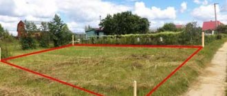
How to clarify boundaries? The land surveying procedure is necessary to indicate the specific parameters of a piece of land on the ground. The previously provided information did not contain the results of clarifying the boundaries; the location indicated the address and total area.
The boundaries must be indicated for registration with the Cadastre authorities and obtaining basic documents for the property. Land surveying takes place in several stages:
- preparatory, during which the engineer studies the available documentation for the land area;
- the main one is the direct determination of boundaries and turning points by a group of surveyors, in which the cadastral engineer, the owner of the site and neighbors participate;
- reporting - checking information and preparing a plan based on the measurements received.
REFERENCE! The procedure proceeds as usual, unless the boundaries are the subject of a legal dispute, errors in the data have been identified, or no overlap of boundaries has been detected.
Neighbors are informed in advance that you want to register the boundaries. The fact of receipt of the notification is confirmed by a signature. If an overlap of boundaries is identified, the registration process may be delayed and require reaching a compromise.
Application for registration
The application for entering information is filled out directly by the owner of the site and must contain the following items:
- Full name of the applicant;
- name of the identity document;
- passport series and number, by whom and when the document was issued;
- data on the certificate of ownership of land, the right of lifelong inheritable possession or perpetual use with the date of its entry into force, an extract from the household register or other document confirming the rights of the owner;
- address and telephone number of the person applying;
- method of obtaining a cadastral passport: at the territorial registration authority, by post;
- applicant's signature.
ATTENTION! The number of copies of the cadastral passport is also indicated. At the beginning of the application is written the line “I request that you enter information about the previously registered land plot into the state real estate cadastre in accordance with the attached documents.”
The following documents are attached to the application:
- a certificate confirming the owner’s rights to the land area (donation agreement, purchase and sale agreement, confirmation of the right of inheritance, etc.);
- plan obtained as a result of land surveying;
- confirmation of payment of state duty;
- document confirming the identity of the applicant;
- a notarized power of attorney, if the application is not submitted by the owner;
The application and copies of papers are submitted to the Cadastre department territorially related to the site. If a legal entity applies to the accounting authority, the list of papers is supplemented with constituent documents. After handing over the package of papers to an authorized specialist, the applicant receives a receipt with the date and signature of the employee.
The amount of state duty for an individual is 200 rubles, for a legal entity - 600 rubles. upon receipt of a document in paper format. A passport in electronic form is cheaper, an individual will pay 150 rubles, a legal one will pay 300 rubles. From the moment of application to the issuance of the finished document, 7–10 days pass.
Change in land status
Is it possible to change the status of the land? What needs to be done to change the status of a land plot from “temporary” or “cancelled” to “registered”? Answering the first question, let’s say: “yes, you can,” but we’ll tell you below how to change the status of a land plot. So, in order to change the status of an entry in the Unified State Register of Land Registers about a land plot from “temporary” to “registered”, it is enough to register a real right to such a property. To do this, you need to submit a corresponding application to the territorial or extraterritorial (if the object is located in another region) branch of the MFC, or directly to Rosreestr (and in any of the possible ways that is most acceptable to you). The complete list of necessary documents to obtain this service can be clarified locally or on the State Services website, since it may be different in each individual situation.
to transfer a land plot from “cancelled” to “registered” than from “temporary” to “registered”. Since it will be necessary to re-prepare the boundary plan, and accordingly the application will be submitted for simultaneous cadastral registration and registration of property rights. If little time has passed and no significant changes have occurred in the legislation regarding the requirements for cadastral registration, you can contact the same cadastral engineer who was involved in the development of the boundary plan initially, with a request to make minor adjustments to the document (for a relatively small fee), and submit it to Rosreestr for repeated cadastral registration and registration. However, land legislation is one of the most unstable in our country, changes are made regularly (almost every six months), so the cadastral engineer is sometimes simply unable to meet you. In this case, you will have to start from the very beginning: collecting documents, measuring the site in situ, preparing a new boundary plan, submitting an application to Rosreestr. Well, we believe there is no point from “registered” to other statuses
Features of such property
The GKN contains data on lands marked “previously registered”.
This means that the cadastral registration of such plots was completed before the cadastral law came into force, or such lands were not registered, but the registration of ownership rights to them was started and not terminated.
Data on previously registered lands after the entry into force of the law were recorded in the real estate cadastre on the basis of an inventory, which means that the boundaries of the lands were not clearly delineated in accordance with legislative acts and did not have clear coordinates.
Also, incomplete information about the lands was entered into the cadastre from the data contained in the document on ownership of the site.
Setting boundaries (clarification)
The state has launched a program to fully enter data into the cadastre in order to identify and fill in missing information regarding plot boundaries.
Many areas that did not go through the process of determining boundaries and area are recorded in the cadastre without indicating the coordinates of the boundaries or are entered inaccurately.
If the boundaries of a previously registered land plot are not defined, it is necessary to make appropriate changes and clearly establish boundaries.
The consequences of inaccurate designation of plot boundaries may be the intentional or unintentional seizure of part of a nearby plot, discrepancy between the actual area and that inscribed in the title deed.
Also, if the boundaries are not determined accurately, payments for the use of land plots may be incorrectly calculated.
In order to establish the exact area and boundaries of the site, it is necessary to carry out cadastral work to measure the territory.
In the process of clarifying boundaries, information from the title deed or from papers about the location of the site when it was formed is taken as a basis.
How many acres of land are in 1 hectare according to the table, see the article: how many acres are in 1 hectare of land.
How to calculate the share in an apartment yourself online for free.
If both documents are not available, the boundaries of the site will be the coordinates assigned to natural or artificial objects for 15 years or more.
With the help of such objects, it is possible to delimit areas and establish clear coordinates, area and boundaries, which will be entered into the cadastre.
Boundaries are clarified in the following situations:
- if the State Property Committee does not contain data on the points, coordinates and boundaries of the plots, its graphic data and plan diagrams;
- if the boundaries and coordinates are indicated with low accuracy;
- if it turns out that the boundaries of one site cross the boundaries of another according to documents.
How to register a previously registered land plot in the cadastral register
Cadastral registration of plots and other real estate is required to secure ownership.
In addition, it is required to calculate the land tax payable based on the area of the plot.
Registration according to the cadastre is the first stage of declaring rights to real estate.
As a result, the owner receives a cadastral passport for the plot and goes with it to the relevant government agency to obtain a document on state registration of rights.
It is impossible to make a site plan yourself. This must be carried out by a cadastral engineer with special accreditation.
He will also draw up an act of compatibility and coordination of the coordinates and boundaries of the land with the owners of neighboring plots.
When registering a plot, the owner must first submit an application to Rosreestr with the attached documents:
- copies of certificates of ownership;
- boundary diagram of the site;
- copies of the belonging of the site to a certain type and category of land, as well as a permit for the use of land.
After registration, the document is issued to the owner personally upon presentation of a passport.
The owner receives a cadastral passport and an extract with data on the latest changes made to the layout and boundaries of the site. These documents are stored until the next cadastral registration procedure.
The duration of the process in the absence of errors or inconsistencies is no more than 10 days. If data is identified that requires clarification, the period may be extended.
The cadastral authority may refuse registration if the land is not subject to inclusion in the cadastre (for example, for protected areas) or if the owner provides an incomplete package of documentation.
Procedure for deregistration
The procedure for deregistration is similar to registration. To remove it, you will need to submit an application to the cadastral chamber indicating the plot number and the reason why the owner wants to remove it from the register.
A copy of the Russian passport, a copy of the title deed, and a cadastral passport must be attached to the application. The decision is made by the government agency within 10 days.
After this, the owner receives the documentation in person with the presentation of a passport or by post with information about receipt.
It should also be noted that certain nuances and problems may often arise when deregistering.
For example, if it is necessary to change the boundaries of a plot or combine several lands into one plot.
This situation may be grounds for deregistration. However, the government agency has the right to refuse in such a situation.
And the only way out for the owner will be to appeal to the court, as a result of which the plot may be deregistered.
Each individual case is considered by the court on an individual basis and does not take into account similar decisions in court proceedings.
Correction of cadastral error
After the adoption of the law on the state cadastre, the process of transferring all data from the archive to the new cadastre began. The process is delayed and complicated if there are errors and inconsistencies.
Situations often occur when a land plot was previously registered, but was not registered with Rosreestr.
To correct cadastral errors, you will need to write a corresponding application to the cadastral authority.
This process must be initiated exclusively by the owner, because the government body cannot begin the procedure on its own.
At the same time, in order to correct errors regarding the area, boundaries of the site or other nuances, documents on ownership of the site will need to be attached to the application.
As a result, after consideration of the case by the cadastral authority, a refusal or a positive decision will be received with the issuance of a cadastral passport with corrected data.
Registration of a passport in accordance with the law will confirm that the procedure for correcting errors was followed and all documents were filled out correctly.
Does it need to be surveyed?
The concept of a previously recorded site means that its boundaries have already been indicated. Information about coordinates and boundaries must also be entered into the cadastre.
There are often situations when there is no data on the register and it is necessary to clarify the boundaries and demarcation of the site.
In the case of a previously registered area, it is only necessary to clarify its boundaries and demarcate them using a simplified procedure.
This happens in several cases:
- if the boundaries were not taken into account and marked at all;
- if the accuracy of marking and surveying is below the standard.
For land surveying, the owner needs to contact the authorized body for regulating the land cadastre.
The land surveying procedure according to a simplified scheme is possible only if after its implementation the number of square meters of the site does not change.
However, in a situation where the area is reduced or increased, coordination between neighbors is necessary.
The cadastral passport and the state cadastre must contain up-to-date information regarding the boundaries and coordinates of the site.
The surveying process is carried out exclusively by an accredited engineer in compliance with all legal requirements.
After surveying and clarification of boundaries, the owner will not be afraid of the territory being seized by neighbors.
After all, the owner will have documentary evidence in the form of a plan diagram of the site with designated boundaries.
Based on paragraph 1 of Art. 130 of the Civil Code of the Russian Federation, land plots are classified as real estate. The concept of “previously registered land plot” follows from the provisions of Federal Law dated July 13, 2015 N 218-FZ “On State Registration of Real Estate” (hereinafter referred to as the Law on Real Estate Registration). Previously registered is considered to be a land plot, the registration of which was carried out before the legislation on the state real estate cadastre came into force, as a result of which cadastral registration was not carried out.
According to Part 4 of Art. 69 of the Law on Real Estate Registration, technical registration or state registration of real estate objects, including those carried out in the manner established by the legislation of the Russian Federation before the entry into force of the Federal Law of July 24, 2007 N 221-FZ “On Cadastral Activities”, is recognized as legally valid, and such objects are considered previously recorded real estate objects. At the same time, real estate objects, state cadastral registration or state registration, including technical registration, which have not been carried out, but the rights to which are registered in the Unified State Register of Real Estate and have not been terminated and which have been assigned conditional numbers by the rights registration authority in the manner established in accordance with the Federal Law dated 07/21/1997 N 122-FZ “On state registration of rights to real estate and transactions with it” are also considered previously registered real estate objects. Entering information into the State Real Estate Cadastre Based on Part 5 of Art. 69 of the Law on Real Estate Registration, if there is no information in the Unified State Register of Real Estate about a previously registered property, the rights registration authority, within five working days from the date of receipt of requests or an application for entering information about a previously registered property, ensures the inclusion of documents and information about a previously registered property in Unified State Register of Real Estate on the basis of: 1) the documentation at its disposal on the previously registered property; 2) a document (a copy of a document certified in the manner established by federal law) establishing or confirming the right to a property, including the document specified in clause 9 of Art. 3 of the Federal Law of October 25, 2001 N 137-FZ “On the entry into force of the Land Code of the Russian Federation” and submitted by the interested party when he submits a corresponding application to the rights registration authority; 3) documents confirming the previously carried out state registration of the specified property or state registration of the right to it or establishing or confirming the right to it and presented by the relevant government bodies, local government bodies or bodies and organizations for state technical accounting and (or) technical inventory, to the rights registration authority at its request, if documents and information about the previously registered real estate are not included in the documentation on the previously registered real estate available to the rights registration authority. Based on Part 7 of Art. 69 of the Law on Real Estate Registration, within five working days from the date of inclusion in the Unified State Register of documents and information about a previously registered property, the registration authority issues or sends rights to the person who requested the information, without charging an additional fee, or to the person who applied for the inclusion information about a previously registered property, an extract from the Unified State Register of Real Estate about the property. In accordance with Part 9 of Art. 69 of the Law on Real Estate Registration, information about real estate objects, the rights to which arose before the date of entry into force of the Law on Registration of Rights and have not been terminated and the state cadastral registration of which has not been carried out, is entered into the Unified State Register of Real Estate according to the rules provided for by this article for entering into the Unified State Register of Information about previously registered real estate objects. According to clause 28 of the Procedure, approved by Order of the Ministry of Economic Development of Russia dated January 11, 2011 N 1, the basis for including in the state real estate cadastre (GKN) information about land plots, the state cadastral registration of which has not been carried out, but the rights to which are registered and not terminated and to which are assigned The body carrying out state registration of rights to real estate and transactions with it, conditional numbers in the manner established in accordance with the Law on Registration of Rights, is the act of including information on previously registered land plots in the State Property Code. The Letter of the Ministry of Economic Development of Russia dated April 20, 2017 N D23i-2207 explains that, according to the Law on Real Estate Registration, rights to real estate that arose before the date of entry into force of the Law on Registration of Rights (real estate that were previously registered) are recognized as legally valid in the absence of them state registration in the Unified State Register of Real Estate, which is carried out at the request of their copyright holders. At the same time, Federal Law No. 93-FZ of June 30, 2006 “On amendments to certain legislative acts of the Russian Federation on the issue of registration in a simplified manner of citizens’ rights to certain real estate objects” state authorities and local government bodies with the authority to provide land plots within the boundaries of the relevant municipalities, are vested with the right to submit to the rights registration authority applications for state registration of rights to land plots intended for personal subsidiary plots, dacha farming, vegetable gardening, horticulture, individual garage or individual housing construction. In accordance with Part 1.1 of Art. 16 of the Federal Law of July 24, 2008 N 161-FZ “On Assistance to the Development of Housing Construction”, the absence in the Unified State Register of Information about previously registered land plots, in respect of which the provisions specified in paragraphs 2 and 2.2 of Part 1 of Art. 12 of this Law, the decision of an interdepartmental collegial body, to the extent required in accordance with the Law on Real Estate Registration, the absence of boundaries of these land plots established in accordance with the legislation of the Russian Federation is not an obstacle to the issuance (sending) of extracts from the Unified State Register of Real Estate about such land plots. Removal of a previously registered land plot from cadastral registration. In accordance with paragraph 3 of Art. 70 of the Federal Law of July 13, 2015 N 218-FZ “On State Registration of Real Estate”, the registration authority in accordance with the established rules for maintaining the Unified State Register also removes from the state cadastral registration a land plot registered in the manner established by the legislation of the Russian Federation before March 1, 2008, in in the event that information about the copyright holders of such areas is not available in the Unified State Register of Real Estate. From the Letter of the Ministry of Economic Development of Russia dated February 10, 2017 N OG-D23-1484 “On consideration of the appeal” it follows: the procedure for the actions of the cadastral registration authority in relation to land plots, the state cadastral registration of which was carried out in the prescribed manner before March 1, 2008, depends on the availability of GKN information about the original land plots or real estate located on them and the presence in the GKN or Unified State Register of Information about their copyright holders, ensuring the possibility of sending a notification to the copyright holder by postal address or e-mail address. If this possibility exists, the rights registration authority sends a notification to the copyright holder. If, within 6 months from the date of sending the notification to the rights registration authority, documents for registration of rights in relation to land plots are not submitted, such land plots will be deregistered. The procedure for the actions of the cadastral registration body is established by clause 181 of Order of the Ministry of Economic Development of Russia dated December 16, 2015 N 943 “On establishing the procedure for maintaining the Unified State Register of Real Estate, the form of the special registration inscription on the document expressing the content of the transaction, the composition of the information included in the special registration inscription on the document, expressing the content of the transaction, and the requirements for its completion, as well as the requirements for the format of the special registration inscription on the document expressing the content of the transaction in electronic form, the procedure for changing in the Unified State Register of Real Estate information about the location of the boundaries of a land plot when correcting a registry error.” It is necessary to take into account that: - the court may declare illegal the cancellation and exclusion of temporary information from the state real estate cadastre at the request of a state authority or local government, if it is established that such exclusion of information was carried out in order to prevent a third party from registering the right to a land plot ; - a dispute about the right or a boundary dispute cannot be resolved only by satisfying the demand submitted to the cadastral registration authority to deregister the land plot.