Issues discussed in the material:
- Goals and objectives of geodetic survey of a land plot
- Cases requiring geo-survey of a land plot
- Types of geodetic surveys of land
- List of works during geodetic survey of a land plot
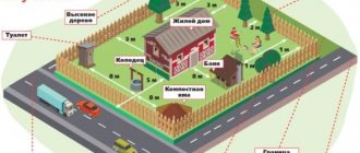
Geodetic survey of a land plot is the measurement and determination of the characteristics of objects on the ground, which will allow the information obtained to be transferred to scale in the form of a diagram on a map. Subsequently, this data is digitized. In essence, such events help to obtain information about the nature of the terrain, various objects of natural origin (rivers, vegetation, etc.), as well as the route of utility networks.
Without this information, it is impossible to build any structures on the land plot. And therefore, special attention is paid to the accuracy of the research conducted. Otherwise, during construction you may encounter unforeseen circumstances that will force you to stop and even cancel the work. And this, in turn, is fraught with significant financial losses. We will talk about the intricacies of geodetic surveying of a land plot below.
What is this?
Currently, construction work cannot be carried out without measurements of the land plot. In this case, geodesy comes to the rescue, namely, the land for design work is marked out, coordinates are established, and heights are determined.
The science of geodesy has as its subject of study the division of lands. If we consider it in a technical sense, it is a science that can provide various branches of human activity. These include cartography, coordinate cadastre, mining, and construction.
HS example
This science helps to obtain measurements on the surface of a land plot, to depict topographical plans and maps. To be able to resolve engineering issues, the direction of engineering geodesy is used.
This science was formed in the 19th century, at a time when industrial revolutions took place. Due to the fact that the pace of construction of buildings and structures increased quite quickly, it became necessary to include objects in the marking of plans.
The engineering direction of geodesy is understood as a group of works that are aimed at studying the characteristics of land plots, its natural features, and building materials. The determination also occurs regarding the availability of water supply to the site.
Types of HS
Due to the fact that this science is applied, the list of its tasks includes:
- surveys that are carried out in various areas of the terrain and its types, with the goal of collecting accurate characteristics;
- design - with its help, the terrain of the site is adjusted, various transformations of the terrain that are required for construction;
- projects are applied to a separate area;
- the axes are divided;
- construction equipment and structures are verified locally, the height must be taken into account, and vertical markings are carried out;
- deformations occurring in structures are measured.
The basis of a geodesy map is a grid of base points, which are determined according to a coordinate system that is the same for everyone. These networks are divided into planned and high-altitude varieties; they are built using trigonometric leveling.
HS Rule
This means that the excess is subject to determination, which is calculated using graduated slats. The process under consideration is called the creation of reference points for measuring the levels of high-altitude areas.
When considering an area that has steep slopes, a theodolite is used for this task. With its help, it is possible to determine altitude points that have a reference value, but this device will require accurate measurements between two points.
Theodolite sample
Determination of plan points is also carried out using this device. In this situation, it is necessary to indicate the directions, distances that add up between the corners and plan points. The triangulation method is used to determine a network of planned reference points.
Angular measurements
A horizontal angle is defined as the angle measured in a horizontal plane between two vertical planes. It is formed due to the difference in directions to the target points, which define the vertical planes.
A theodolite can be used to measure directions.
Electronic theodolites have telescopes and graduated circles similar to optical theodolites. Microscopes are equipped with optical-electronic scanning systems. The microprocessor controls and evaluates the operation of the device.
In combination with an electronic distance measuring unit, an electronic theodolite can also be used in tacheometric surveys. The zenith angle is measured using a vertical theodolite circle. The observed zenith angle refers to the local direction of the plumb line and the curved beam of light. This method of geodetic distance measurements establishes the scale of topographic networks.
The angular method measures horizontal and vertical angles. Instruments used: theodolites, tacheometers.
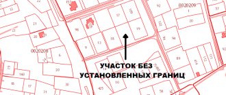
Differences from cadastral survey
The cadastral type of survey is intended to determine and restore the boundaries of land plots. This type is closely associated with geodesy, due to the fact that its implementation requires appropriate measurements.
The difference is that the cadastral type consists of a set of actions aimed at assigning the boundaries of the plot. In this case, coordination with the owners of adjacent plots is required.
The objectives of the survey are:
- land surveying, which is what geodetic work actually consists of;
- the area of plots is agreed upon with all plot owners;
- the boundaries of the territory that were violated are restored;
- rules are established regarding restrictions and use regarding the use of the allotment and natural resources;
- creation of a cadastral plan.
Cadastral survey of a site
The main difference is the focus of the types of surveys under consideration. When they talk about a geodetic survey, it is believed that there are more general measurements of the plot, which can be referred to when carrying out further work.
Cadastral surveying uses a variation of geodetic surveying for specific purposes. An example would be a list of land plots, the natural resources that are available on them, the preparation of documents and cadastral registration.
The main goals of geodetic work
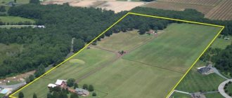
Geodesy of a land plot is necessary not only in the case of construction work, since the scope of practical application of research results is much wider.
It is worth noting that land surveying is required in the following cases :
- Land surveying
- Cadastral registration
- Merger or division of plots
- Imposing new boundaries
- Sale/purchase of land
- Registration of ownerless land by allotment
As you can see, geodetic work is generally required in almost any legal transaction with land. Such procedures are performed primarily to obtain specific data and bring them into accordance with the general topographic plan of the area.
Site geodesy is used not only for lands intended for individual housing construction, but also for others belonging to different categories: for farming, recreational resources, and so on.
You need to understand that land geodesy is one of the stages of cadastral work, before which there is preliminary planning, and after that there is desk processing of the received data.
Kinds
If we take as the basis for division the method that is used when using various kinds of measuring instruments, we can distinguish:
- surveys carried out on the ground;
- those carried out using aircraft;
- combines land and air transport;
- which are performed using satellites.
Types of surveys
In turn, surveys that are carried out on the ground can be divided depending on what the ultimate goal is being pursued and in what area it is applied:
- facade orientation;
- topographical;
- reference value;
- vertical or floor-to-ceiling;
- special varieties.
These surveys are usually ordered in order to carry out the design of various types of construction work and improve the territory. The goal may also be to ensure that a state land cadastre is formed, land management is carried out, and disputes that arise are resolved.
Leveling (measurement of excesses)
In geometric leveling, differences in height are determined using horizontal sight lines between points in close proximity to each other.
Leveling is carried out using a level and leveling rods. The line of sight is brought to a horizontal position using a bubble in combination with an inclined screw or automatically using a compensator.
The compensator is an optical-mechanical part with a gravitational pendulum. Precise levels are used for leveling with the highest precision. The measuring rods used are 3 m invariant rods with two opposing and stepped graduations.
The method of geodetic measurement of elevations determines the difference in heights of surface points. Equipment used: levels.
The need for
Geodetic surveying refers to complex work that begins with determining the geographical location of the object being prepared for construction. The feasibility of the technical and economic location must be taken into account. They determine the quality of the soil and its composition, and whether it is possible to use it as a resource for construction purposes.
In addition to the fact that measuring work on the ground is required for various types of design activities, also in relation to the production of the entire set of geodetic works, it is possible to obtain an accurate layout of the plot, which reflects all the buildings, structures and lines of technological significance located on it.
Sample geological basis of the plan
This plan is called geobasis and its implementation takes place on a scale of 1:500. The period during which this act is considered valid is four years.
During this period, it is necessary to carry out the entire range of design work that needs to be carried out on the site. The result of a geodetic survey can be obtained a plan of the plot, which reflects all its dimensional characteristics, which are linked to objects located on the ground. Data for all types of design of structures and buildings is also reflected.
The main task
Geodetic survey is a general name for work that is carried out for further geodetic activities and consists of collecting and documenting the necessary information, as well as creating special engineering documents.
The documents processed during the execution of the task indicate the location of objects, buildings and communication systems on the ground.
The method of carrying out activities, the reliability of information and their accuracy are reflected in the final document (drawings or diagrams) and depend on the conditions put forward by the customer.
The main task of geodetic survey is the collection and documentation of information that allows the creation of three-dimensional models, plans, drawings or diagrams with detailed information on the terrain, located buildings, communication systems and existing structures.
Compound
When considering the composition of this activity, we can say that the first element is the development of a geodetic basis. This activity includes the breakdown of the territory on plans reflected in electronic and paper form, control marks and axes are also applied to places, and highways and linear networks are designated.
The next element is the breakdown of linear objects into areas. A distribution network for installation is also carried out, measurements of building parameters are monitored and work is carried out to deal with any defects in the constructed facility. Engineering direction is monitored during the use of the object, and existing deformations are observed.
Creating a geodetic alignment base
They begin to carry out geodetic work after the construction site is fully prepared. First of all, surveying and surveying work is carried out. This looks like transferring the axis to the ground; the territory is marked out according to plan and elevation marks.
Next, tracing actions are carried out, that is, the route is laid out on site, which consists of sections equal to 100 meters and diameters. During tracing, specialists use pickets, which are subsequently secured with pegs. The result of this activity is a picket magazine.
Then they begin to carry out an as-built survey, through which it is determined whether there are deviations from the project and the accuracy of the work performed. If there are inconsistencies between the constructed structure and what is reflected in the design documents, this is reflected in the acts.
Executive SG
By using performance imaging during installation work of structures, existing errors and deviations can be identified that can be corrected.
The purpose of surveying is to control the quality of construction work being performed. From the beginning of all activities and before its completion, specialists measure the deformations of buildings in order to be able to adjust the construction process.
All considered stages of this process are mandatory for use, and it is necessary to strictly follow the construction plans, since they are expressed as the main component of construction and installation work.
Primary survey
When arriving at the site, you should not immediately rush into battle and tear your vest on your chest. You need to sit down, drink some tea and slowly think about how to most effectively organize your work. Ideally, you first need to find a responsible person on site and clarify with him the scope and types of work. Usually there is always a sane and knowledgeable guy on site. For a construction organization, this is the site manager or construction and installation work foreman (construction and installation works). For field exploration, this is a master. If this person does not want to help you and make contact, explain to him in a popular manner that by doing a bad job, you will annoy not only yourself, but also him, as a responsible person. So cooperation with you is a profitable offer. Although usually these comrades are willing to help with work.
During the initial survey, you may unexpectedly learn various interesting details. To the point where they will tell you that a week ago guys from another city already arrived and have already photographed the area you need. After that, they can give you their footage, which you just need to check. So sometimes this happens - the object is designed for two weeks - we arrive - the old footage is handed over - it is checked - we put our stamp - we can rest for a week and a half. Russia…