What is the purpose of the site?
The intended purpose of a site is a narrower and more applied concept that deciphers and specifies the permitted activity defined by the category. That is, if a certain plot belongs to the category of agricultural land, then its intended purpose may be gardening, growing various crops, and breeding fish or animals.
What types of memory are there?
What types of land use are there? According to Art. 7 of the Land Code of the Russian Federation, the entire territory of the state is divided into:
- agricultural land;
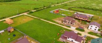
- lands of populated areas;
- lands of industry, energy, transport, communications, radio broadcasting, television, computer science, lands for space activities, lands of defense, security and lands of other special purposes;
- lands of specially protected areas and objects;
- forest fund lands;
- water fund lands;
- reserve lands.
Let's look at the main differences between the categories and their purposes.
- Agricultural land is one of the most extensive categories, covering all territories with fertile soils, where individuals and legal entities, government, commercial and non-profit organizations can engage in various types of agriculture.
- Lands of settlements - all areas within the administrative boundaries of settlements, which in turn are zoned by local authorities according to their purpose (residential, industrial, recreational and others).
- Industrial and special-purpose lands are the most versatile category, uniting territories where industrial and other activities with high technogenic risks are permitted.
- Lands of specially protected territories and objects - the category combines:
- Lands of specially protected natural areas - here it is strictly prohibited to allocate dacha and garden plots, lay roads and communication lines, place any industrial, economic or residential facilities not related to nature reserves, parks and other objects of the territory.
- Lands of medical and health resorts and resorts are areas that have natural resources for the treatment and preventive health of citizens, sources of mineral waters and similar conditions. Sanitary protection districts are established in such territories.
- Lands for environmental purposes are areas occupied by protective forests and water protection facilities. Economic activity in these territories is permissible, but limited by the land protection regime.
- Recreational lands – this subcategory includes lands occupied by tourism, sports, and active recreation facilities. Any other economic activity is prohibited.
- Lands of historical and cultural significance - places of location of historical and cultural monuments of Russia and its peoples, places of traditional crafts, lands under military and civilian cemeteries. Changing the intended use of these lands is prohibited.
- Particularly valuable lands are territories where unique natural and other objects of scientific or historical and cultural value are located.
- Water fund lands are areas covered with water or occupied by hydraulic structures. Land plots in these territories are not allocated; additional areas may be reserved for the construction of artificial reservoirs.
- Forest fund lands - all areas covered with forest and places where it is planned to be restored, as well as related objects (clearings, roads, etc.).
- Reserve lands are land areas that have not yet been distributed and are in demand with an uncertain purpose. They are in municipal or state ownership and must be transferred to the appropriate category in order to be used.
Digital coding is applied to the types of permitted use of a land plot. For more information about the land category code, in what cases and where it is indicated, as well as how to decipher it correctly, read here.
What does this mean and what could be the consequences?
When performing any actions with land, you must be sure of its category unconditionally, otherwise the rights and obligations of the owner associated with this site may be challenged, and the property owner may suffer.
May be recognized:
- illegal - the decision to allocate a land plot;
- inappropriate - legal regime of use;
- invalid - contracts related to the site.
If a land owner submits documents to register a plot without a confirmed category, he will be denied registration .
The ability to carry out any actions with the land will be limited.
It will become impossible:
- re-register it;
- obtain permission to begin construction;
- legitimize the completed;
- use the site in some way, etc.
There will be problems with determining the subject of law.
In addition, if there is no category of land, it means that there is no intended purpose for the site; it can be classified as a reserve fund .
Undesirable consequences of uncertainty in the category of land arise not only for the owner, but also for the state. The owner does not dare to use the land as planned, since there is no permission for this, which means he does not pay tax on the cadastral value of the plot, etc.
Procedure
In general, changing the permitted use of land is carried out in the following order:
- The land user collects the necessary documents and submits an application to the head of the executive branch;
- If the application is drawn up correctly, the town planning and land committees form a commission;
- The Commission sends notices of upcoming hearings to land users whose plots are located in the same zoning area as the applicant's plot;
- Public hearings are held;
- Based on the results of the hearings, the commission makes a decision;
- If the decision is positive, an act on changing the VRI of the declared site is drawn up;
- Based on the act, changes are made to the Unified State Register.
A sample application text can be downloaded from this link. The application must include the following information:
- Full name and contact information of the land user;
- Category of land and address landmarks of the site;
- Current and requested VRI;
- Reason for changing land use;
- List of attached documents.
The maximum period between the distribution of notices of hearings through the media or mail and the commission’s adoption of a decision is established by local legislation, but cannot exceed 30 days (Clause 7, Article 39 of the Urban Planning Code).
During public hearings, the applicant speaks, arguing for the need to change the VRI, and interested parties express their opinions on the consequences of changing land use to members of the commission.
Dissenting opinions and objections must be submitted to the commission members in writing.
When making a decision, the commission is guided by the following factors:
- The feasibility of changing the VRI;
- Consequences of changes in VRI for the environment;
- Legal and economic consequences for neighboring land users.
For example, if the owner of a gardening plot wants to change the VRI to build a house, the commission may reject the application due to the threat of shading of the neighboring cultivated plot.
If the commission decides to change the type of land use of the site, a copy of the decision is sent to all participants in the hearing. 10 days after the decision is made, an act on changing the VRI is drawn up, a copy of which is issued to the applicant. The applicant must contact Rosreestr to register changes in the cadastral register, attaching the following papers to a copy of the act:
- A copy of your passport;
- Receipt for payment of state duty;
- Application for amendments;
- Cadastral passport for the plot.
The new type of permitted land use will be displayed on the cadastral map of the area within 7-10 days from the date of application to Rosreestr.
If the applicant does not agree with the decision of the commission, he can challenge this decision in court (clause 12 of article 39 of the Civil Code of the Russian Federation).
Where to find out
Let us consider in detail how to determine the category of a land plot. There are several options where you can turn at once, you can find out:
- in Rosreestr , having issued a cadastral extract;
- on the Rosreestr website, having studied the public cadastral map;
- by cadastral number;
- to the Federal Tax Service ;
- in administration ;
- in FUGRTs ;
- in the documents for the site.
Extract from Rosreestr
How to find out the category of a land plot through Rosreestr? Today there are two information banks where you can find out all the data about real estate. These are Register of Real Estate (EGRN) and the State Real Estate Cadastre ( GKN ).
All data on rights is contained in the Unified State Register, and there is also information about copyright holders.
In the State Property Committee you can find information about the status of the object and its value.
It also lists the characteristics of the object and how it is allowed to be used.
The services are administered by Rosreestr and the cadastral chamber, which is subordinate to this institution.
Any person can request data from the State Property Committee and the Unified State Register , but only the copyright holder or his representative has the right to receive originals and copies of information about the supporting documents. The latter must have a power of attorney certified by a notary office.
You can request the following cadastral documents from the State Property Committee:
- reference;
- passport;
- extract.
obtain complete information about a land plot from a cadastral extract . An individual will issue it for 400 rubles if he needs a paper document. In electronic form – 150 rubles. The extract has no expiration date.
You can get it at the MFC , by visiting the center in person, or by contacting the cadastral chamber. When applying in person, you must have a passport or power of attorney. If a legal entity applies, this must be done by the director or his representative. It is also necessary to attach a receipt confirming payment of the state fee.
When sending a request by mail, it must be sent to the address of the institution that is located in the area where the property is located.
You can obtain the document online by visiting the Rosreestr website:
- go to the “Activities” tab;
- select “Providing government ;
- find the paragraph that says about providing information electronically;
- Next, you need to select “Submit a request” and fill out all the fields of the form.
After completing the procedure, you will receive an email notification that your application has been accepted.
A paper statement will be ready within 5 days from the moment the payment is completed. The document on electronic media is usually issued the next day.
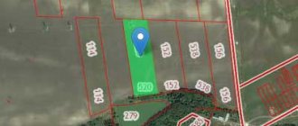
Cadastral map
This is a public project that anyone can use. The map can be found on the Rosreestr website. The service is free.
After studying the map, you can get all the data about the areas that are in the state cadastre. The card is often used by specialists, for example, realtors and lawyers. Thanks to the project, you can obtain the information you are looking for, and only then issue an extract about the site.
The map shows the boundaries of the territories and their cadastral number. There is also information about land categories and how they can be used.
There is information:
- about the cost of plots,
- about buildings located on the lands and other information.
By studying the map, you can obtain general information that is needed to work with the land plot. Please note that this information is indicative, so studying the map will not replace information from documents.
Cadastral number
If it is known, then you can use it to find out the technical characteristics of the site .
If the number is not known, it can be found by finding the land plot on the public cadastral map.
This can be done either by address via search or visually.
Knowing the cadastral number, you can contact Rosreestr and get information.
When visiting in person, you must provide a passport, as well as a document confirming ownership of the land.
At FUGRTs
You can also obtain information about the category of land from the Federal Office of the State Registration Center by paying a fee of 100 rubles. and making a statement.
The Federal Tax Service
This service has all the information about the owner of the site. But outsiders will have to explain why they need the information. This is true for all services.
District administration
In the municipality you can find out about:
- land surveying,
- land categories.
You can contact the administration in person or write a statement by sending it by mail . In addition, the interests of the interested person can be represented by his representative, who has a notarized power of attorney.
In documents for the site and during land surveying
The category is indicated in the technical documents issued for the site.
Information can be found in contracts, if the subject of them was a land plot, in various acts that were issued by the authorities of the subject or local government.
Also, the title document is issued after land surveying .
To do this, you need to contact a specialist or organization that offers such services.
A specialist or organization must have a license.
Kinds
The types of intended purposes of the land plot are as follows:
- individual housing construction;
- LPH;
- DNP;
- SNT.
Let's look at each type in more detail.
individual housing construction
IZHS stands for personal housing construction. This status is given to land plots within a locality, which are used for the purpose of constructing residential real estate.
The advantages of individual housing construction are quite obvious:
- you can carry out construction and register the ownership of buildings;
- the ability to assign an address to a house and register there on a permanent basis;
- the presence of a complete list of legal possibilities in relation to the plot, in other words, it can be sold, donated, and so on.
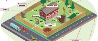
Additionally, it is necessary to pay attention to the fact that an allotment for individual housing construction is most optimal for private construction, since this is what it is intended for
Private household plots
Private household plots are one of the forms of activity of citizens, which is aimed exclusively at the production of agricultural goods and processing.
In order for a plot of land to be included in private household plots, it must meet the following requirements:
- the owner does not plan to receive income from it in the future;
- there is no hired staff;
- All products are manufactured solely for personal use.
Additionally, it is necessary to pay attention to the fact that the land on which the activity is carried out is presented or purchased for the purpose of running private household plots and there is a corresponding mark about this
DNP
DNP stands for dacha non-profit partnership. In essence, this is the same as SNT, but there are some features.
In a situation where a dacha partnership is located within the boundaries of a populated area, then in terms of its parameters the plot is practically equivalent to plots for personal housing construction.
This happened largely due to the introduction of the so-called “dacha amnesty.” From a theoretical point of view, DNP plots cannot be used for the purpose of housing construction, and has its own disadvantages.
SNT
SNT stands for horticultural non-profit partnership, in other words, an association of amateur gardeners.
Such plots, in most cases, are located outside the boundaries of the populated area in areas of agricultural use.
On the opposite side:
- the land cannot be used for the purpose of constructing residential real estate;
- connection of the site to various communications is carried out at the expense of its own financial resources;
- Regardless of what characteristics the house has, it will in any case acquire the status of a “country house”.
Please note: if there is a residential building on the site, it is almost impossible to make any transactions with it.
Main types of land use
The main types of use of a land plot are the basic legal regulations, or the grounds on which the activities of the owner or tenant are guided when developing the land plot.
They set the main trends, allowing, based on the category of land:
- construction of a capital structure;
- organization of a summer cottage;
- organization of personal subsidiary farming;
- commercial agricultural activities;
- Building bussiness;
- other work in accordance with the obtained permission to use the land.
The choice of the main type is at the discretion of the owner, on the basis of clause 2 of Art. 7 Land Code of the Russian Federation. If we are talking about the lands of populated areas, the following norms of the Town Planning Code additionally come into force:
- Clause 1 of Article 9 of the Civil Code of the Russian Federation;
- Part 2 and Part 6 of Article 30 of the Civil Code of the Russian Federation;
- clause 1, part 3 of article 37 of the Civil Code of the Russian Federation;
- Part 4 of Article 37 of the Civil Code of the Russian Federation.
The main type is completely guided by the rules for the development of zoning territory adopted by the local municipality represented by the land department. If we are talking about development within the city limits - the department for architecture and construction.
Taking the main type of use of a site as a standard, its owner accepts the local orders established by the indicated authorities for the development of the lands belonging to him.
Basic indicators are the numerically expressed norms provided for the use of the site. They are included in the classifier approved by Order of the Ministry of Economic Development No. 540 of September 1, 2014.
Here, each land category represents its use options, which are encoded with numeric symbols. When choosing the main type of permitted use, the landowner chooses the appropriate method of organizing work on the site and enters the specified code into the documentation.
For example, the residential development code is 2.0. Paragraph 1 provides for the construction of low-rise buildings. Accordingly, indicator 2.1 is the permitted type of use for land intended for individual housing construction.
Are there any permitted uses?
If the category is not established, then the land is in limbo , “outside the law,” so there can be no talk of any VRI. You cannot enter into transactions or draw up title documents. Direct use of the site is also prohibited: construction, farming, and other activities. In fact, they manage to sell such plots using various tricks.
The only way out is to achieve the assignment of the required category to the site. This process is difficult and depends on many factors.
How is land transfer carried out?
How to change the purpose of land? Despite the fact that each plot has a specific classification, in some cases an interested person or its owner can initiate the procedure for changing the category of land. So, in order to carry out this procedure, you need to take the following steps:
- Submit an application to the land committee under the administration of the district in whose department the corresponding plot is located, with a requirement to carry out this action to change the intended purpose.
- To analyze the application, the department takes a regulatory period of 60–90 days, during which it analyzes the fundamental possibility of changing land categories, as well as the nuances and consequences arising from this action.
- If these lands are not subject to a federal ban or they are not burdened with any government programs or do not constitute strategic lands, then the department can give consent, and the procedure will be completed within 15 working days.
Important! In fact, as a rule, most sites are transferred for quite a long time, since district, regional or federal authorities always come with clarifications on the development plan of the territories, the presence of restrictions in these areas in the form of environmental zones and other encumbrances associated with the impossibility of exploiting the land in accordance with with the desired purpose. Therefore, the interested party should inquire about successful cases of completion of this operation before changing the use of land
To summarize, it should be said that the unauthorized use of land for purposes other than its intended purpose can have very dire consequences for its owner, especially if the non-targeted activities of an enterprise or individual affect the interests of third parties. Thus, for a violator, in accordance with judicial practice in the country, it is possible to apply penalties, dismantling constructed structures, the impossibility of registering them as real estate, as well as criminal proceedings if the activities of this person caused severe harm to others or their property.
Settlement lands
Is it possible to expand ritual areas?
The state stipulates that disposal areas require expansion or new localization. Therefore, of course, actions to cover additional territories are quite legal and legally correct.
However, this procedure is conditioned by a number of resolutions that require the municipality to strictly report and weigh such actions. That is, according to Federal Law No. 8-FZ, the expansion of ritual sites or the formation of new ones requires the following :
- Development and submission of a development plan for the specified zone.
- Boundary project for the ritual zone.
- Special permit with a positive conclusion from environmental and sanitary-hygienic examination.
This, of course, takes into account the fact that the designated territories border on residential buildings of citizens. The protective zone of distance from the city cemetery must be at least 500 m.
Main types of permitted use of land
Depending on the intended purpose of the land, each plot in turn has its own type of permitted use with the assignment of a corresponding numerical code. So, the gradation of these lands is as follows:
- Land for agricultural activities - code 1, is divided into 18 categories, according to which on this land it is possible to engage in livestock farming, crop production, erect agricultural buildings, carry out various breeding and other activities in accordance with the status of the land.
- Settlement lands - code 2, contains 7 main subtypes, namely individual residential buildings, high-, medium- and low-rise apartment buildings, personal gardening for organizing gardening for personal purposes, etc.
- Sites proposed for the placement of public buildings and structures, code 3, includes 10 subparagraphs and implies the right to locate public utility facilities, medical institutions, schools, preschool educational institutions, universities, buildings intended for social security of the population and other similar objects.
- Land intended for business and other commercial activities, having a classifier number 4, which includes 10 types of objects, in particular, trade enterprises, hotel business, roadside service, public catering, etc.
- Areas allocated for recreational and park areas intended for the placement of similar, including sports facilities. They are recorded in the register under code 5 and contain 5 items.
- Industrial lands for the construction of plants, factories and their infrastructure, ancillary buildings, code 6, consists of 11 types.
- Sites for development for transport infrastructure, code 7, including 5 categories.
- Lands for the placement of objects of military and strategic importance are located under code 8 and consist of 3 points.
- The last code among the types of permitted use is 9, which includes 2 subparagraphs and involves engaging in activities to protect natural objects.
Land Committee
Important! Depending on the location of the site and its significance on the general plan of the settlement and the adjacent territories, each site, according to its cadastral passport, has one of the codes listed above. On each document for land, these quality indicators must match, otherwise the papers are considered invalid
Documentation
The application is accompanied by documents that can confirm the authenticity of the applicant’s identity (if we are talking about people with the status of an individual) or confirm the legality of the actions of an individual entrepreneur or legal entity (extract from the unified state register of individual entrepreneurs or legal entities), an extract from the Unified State Register of Entrepreneurs or legal entities, the specific area in respect of which the procedure is to be carried out.
In the event that the current legislation provides for the need to conduct a specialized environmental assessment in relation to a particular site, an expert commission’s conclusion based on the results of the work performed will also be required.
The entire package of documents is checked by employees of the relevant executive authorities for compliance with the requirements of the current legislation of its contents and the person who submitted this package.
If the documents or the person who submitted them do not comply with the specified requirements, all papers are returned to the applicant within no more than thirty days from the date of their receipt, accompanied by a reasoned refusal to accept with a detailed indication of the reason for the refusal.
Within three months, documents are reviewed by the Government of the Russian Federation in relation to lands transferred to its jurisdiction. Two months are allocated to executive bodies in the constituent entities and municipalities.
Based on the results of consideration of the application, a corresponding act is issued, which indicates the assigned category or established type of permitted mode of use or intended purpose, and the date of the decision on such establishment.
Such an act does not have an expiration date, since the next one can be adopted at any time as a result of the occurrence of relevant grounds.
Within fourteen days from the date of recording the decision by drawing up an act, the latter must be sent to the applicant.
You will find out the length of service for retirement in Russia under the new law in our article.
In 2021, Russian military pensions will be increased! Find out more about this event in the article.
There are some changes to unemployment benefits in 2021. Our material has all the information you need.
Forms of ownership of land plots
The current version of the Constitution has given Russians the opportunity to register private ownership of land plots.
Private land can belong to both a citizen and a group of persons with the status of a legal entity, partnership or non-profit organization. But also a certain part of the lands, according to Article 9 of the Constitution, remained in the possession of the state and municipalities (local authorities). A mixed version is also allowed.
Chapter 3 of the Land Code is devoted to issues of forms of ownership of plots. The rights of private and public ownership of land are contained in Article 17. Civil Code.
Depending on the form of ownership, different rules apply regarding the turnover of plots. Today anyone can find out what form of ownership applies to a particular memory. Such information is available on the public cadastral map from Rosreestr. To obtain the necessary information, you need to know the cadastral number or the exact address of the site.
Is it possible to change the purpose of a land plot?
The purpose of the land is determined by the class to which the site belongs. Information about this is included in the concept of cadastral lists, along with data on location, number of owners and other characteristics entered into the register. Based on this data, the site is assigned a specific destination category.
You can change your appointment; there are different options for this:
Change resolution. Occurs within one category. For example, a plot of land is intended for vegetable growing, but the owner wants to raise livestock and needs land for pastures. In this case, the permit changes, but the category itself (agricultural purpose of the land) does not change.
Reasons
Carrying out such events is possible only on the grounds listed in the current legislation (Article 14 of the Federal Law “On the Transfer of Lands...”). In accordance with the provisions of this article, the following grounds should be highlighted:
• Determination of the category of a plot in accordance with the data contained in the databases of the Unified State Register of Real Estate (USRN) based on the information contained in pre-existing cadastral documents for this plot;
• Classification of a plot of land to one or another category in accordance with the application of its owner on the basis of the documents available to him confirming the ownership of the plot, which indicate the category of the plot (relevant for entering information into the Unified State Register of Real Estate when the owner of the plot changes, if there is other documentary evidence of the assigned category there is no site);
• Transfer of land allotment from one established category to another (for example, from agricultural land or reserve land to land in populated areas);
• If a factual error is identified in the classification of certain land plots to different categories (a contradiction is found between the state registers of forestry and agricultural lands and the Unified State Register of Real Estate - the information contained in the Unified State Register of Real Estate will be used).
What to do if there is data in the title documents, but not in the register?
Lands can be categorized based on data from the Unified State Register and title documents. Moreover, title documents have great legal force. If they indicate a category, then you can enter this data into the Unified Register of Real Estate Rights.
In fact, it is enough to contact the register, pointing to the relevant document, as well as the provision of Federal Law 172, Article 14, Clause 2 . If the documents are valid and comply with all standards, the register must make appropriate amendments regarding this site.
If they refuse, then you need to take the path of petitioning the local authorities. In this case, the basis will be the title documents, which indicate the category of land.
Advice! If such old-style documents were issued by the RSFSR, then most likely you will have to go to court. However, even when filing an application, such documents will be considered evidence of the intended purpose of the site.
How to change land category
bloodua/Depositphotos
According to the laws of the Russian Federation, all lands are divided into a number of categories: settlements; agricultural purposes; industrial and social purposes, as well as some others. Only on land plots of the first two categories does the law allow the construction of housing, and only these territories have all the rights to create a comfortable life.
The type of permitted use (AUR) of a land plot for individual housing construction is relevant only for the lands of populated areas, for example cottage villages, where residence and registration are permitted.
How to choose and buy a plot for construction?
On what categories of lands can one build and on which ones cannot?
In other words, the “category of a land plot” and the “type of permitted use of a land plot” answer the question of what capital construction projects can be legally built on this land.
The main difficulty lies in the master plan
The law of our country does not provide for the transfer of land from one category to another at the request of the owner. Changing it from “agricultural use” to “land where you can build a private house” will not work. The basis for such a change can only be a new approved general plan of the territory. In this regard, the district administration must provide for such a change. Only in this case the owner has the right to submit a petition to the administration to change the category of the land plot.
They consider the application for up to two months, and after that, within another couple of weeks, a positive decision or refusal is issued.
If the answer is “yes”, then the owner of the site receives an act indicating:
- reasons for changing the category;
- boundaries, area and cadastral number of the plot;
- the category to which the land belonged, and the category to which it will now belong.
Is construction allowed on SNT lands?
Three critical nuances when purchasing a plot for individual housing construction
reason for refusal to change land category
You will be refused to change the category of a site if the site is located at a distance from the boundaries of a populated area and the administration’s plans do not include developing and expanding the nearest settlement.
Even before starting the whole process, it is worth considering other factors. For example, a change of category will be denied if the environmental assessment turns out to be negative; if the intended purpose of the land does not correspond to land management documents; if the site falls into categories such as pasture, meadow or similar.
Service cost and taxes
Firstly, when the category of land changes, the tax on it will also change. But if the land was not transferred to another status, and a residential building was allowed to be built on an agricultural plot, then the tax rate will remain the same. Covering changes in the cadastral value of the site is the most expensive part. And the owner must pay for it. The amount can reach 30% of the cost of the land. The cost of the procedure will also be affected by the size of the plot, services for preparing documents, creating a project for the future home, and, if necessary, an environmental assessment.
Can I transfer my land to the individual housing construction category?
Why is it easier to change the category of land if there is a cemetery nearby?
The situation is different with the types of permitted uses. They can be changed and are even easier than a few years ago. If in your territorial part of the Land Use and Development Rules (LRU) you, as the owner of the site, have the right to change the VRI, then just follow the instructions.
Specify the area of your site
You can do this on the website of the administration of your territory (district)
Having learned the name of the land zone, it is important to clarify its decoding and the entire list of permissible types of permitted use
How is it determined?
When a land mass is initially registered for cadastral registration, a commission specially created for this purpose determines which category the land will be classified into.
From the state reserve it is transferred to the lands of the corresponding region, which, in turn, secures its purpose by a special act .
This characteristic of the land is not constant and, if necessary, can be changed by decision of the regional authorities.
Later definition of the category (and its change) depends on whose jurisdiction the land is in .
If this:
- federal property, then the Government of the Russian Federation;
- if a subject of the Federation, then the executive body of the territory, region;
- being in municipal ownership, then by municipal authorities;
- private, then by local governments.