The layout of a land plot or land plots on the cadastral plan of the territory is an image of the boundaries of the land plot or land plots being formed on the cadastral plan of the territory. The diagram indicates the area of each land plot being formed and, if the formation of two or more land plots is envisaged, their conditional numbers are indicated.
What kind of document is this?
The layout of a land plot is a document, a drawing on paper, which displays the boundaries of the territory formed or redistributed according to the cadastral plan.
It must be attached to a document issued by executive authorities, which describes the characteristics of a given plot of land. The order clearly states the coordinates of the territory with an accuracy of meters, its area and shape. A civilian has every right to prepare the drawing independently, but in order to avoid mistakes, delays in the procedure and fines, you should immediately contact the specialists of the GeoStroyProekt company and entrust this process to them.
When do you need a land plot layout diagram?
The layout of the land plot is required:
- To form a specific plot when it is transferred without bargaining
- If the formed plot will be sold at auction or rented out
- If the territory is allocated from land that belongs to a municipality or legal entity on terms of use without a time limit
- If a land plot that belongs to the state or is given to a legal entity or individual for rent or for free exploitation is divided
- If plots are formed during the redistribution of territories that are in the possession of individuals and are intended for maintaining a garden, vegetable garden, other rural work, individual housing construction, etc., or the land that is owned by the state
- To prepare and determine a plot of land, which will then be withdrawn in favor of the municipality or the state
What is shown on the diagram?
The layout plan of the land plot must necessarily show:
- Conditional number.
- The area in accordance with the design of each allocated territory.
- A list of coordinates of border points of all participants in accordance with the planning organization scheme of the land plot in the system that is established for maintaining the state real estate cadastre.
- Configuration of the boundaries of newly received, already recorded and original land territories.
- Conventional signs that were used in preparing the layout of the land plot.
- All information about plan approval. If it was certified by certain authorities, it is required to indicate which ones, as well as the date, name of the document and its number.
- If the plan was approved through an agreement between various authorized bodies, then it will be necessary to indicate the names of these organizations, the name of the certificate, its number and when the agreement was concluded.
The Land Code provides for the possibility of transferring state land into ownership, lease, and free use to individuals and legal entities. To consider the possibility of forming the site you are interested in, it is necessary to provide the executive body of state power or local government with a diagram of the location of the site on the cadastral plan of the territory.
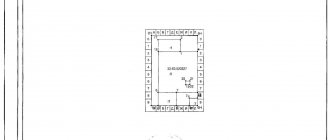
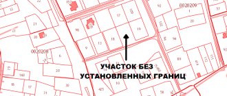
The layout of the land plot on the cadastral plan of the territory is a diagram that displays the projected boundaries and area of the requested land plot on the cadastral plan of the territory.
The layout of the land plot is prepared taking into account approved territorial planning documents, land use and development rules, draft territory planning, land management documentation, regulations on specially protected natural areas, the presence of zones with special conditions for the use of territories, public land plots, public areas, red lines , location of land boundaries, location of buildings, structures, unfinished construction projects.
The layout of the land plot shows:
- conditional number of the land plot being formed;
- land area;
- list of coordinates of characteristic boundary points;
- image of the boundaries of the land plot being formed, image of the boundaries of the registered land plots, including the original land plots, inscriptions, symbols;
- information on approval of the layout of the land plot.
The layout of a land plot is approved by a decision of the authority authorized to provide state or municipally owned land plots. The validity period of the decision to approve the layout of the land plot is two years.
Grounds for refusal to approve the scheme:
- non-compliance of the layout of the land plot with the requirements for its preparation;
- coincidence of the location of the land plot being formed with the location of the land plot formed in accordance with a previously made decision on approval of the layout of the land plot, the validity of which has not expired;
- development of a layout plan for a land plot in violation of the requirements of the Land Code;
- discrepancy between the layout of the land plot and the approved draft territory planning, land management documentation, and regulations on a specially protected natural area;
- location of the land plot within the boundaries of the territory for which the territory surveying project has been approved.
If a positive response is received, the applicant must ensure that cadastral work is carried out to form the site in order to register it with the state cadastral register. You can order a service for producing a layout diagram from our specialists by contact numbers or leave a “Call me” request.
How to prepare a land plot layout diagram
To prepare a diagram of the location of a land plot on a cadastral plan, today it is most convenient to use an electronic document format. But there are cases when a plan is needed by a civilian in order to transfer a plot of land without bidding. In this case, it can be made in two forms - in the form of an electronic document or a regular paper document.
In the preparation process, it is permitted to use the official website of a federal executive body that has the appropriate powers. The requirements for preparing a land plot location diagram in electronic format are officially approved by the Order of the Ministry of Economic Development of the Russian Federation dated November 27, 2014.
How to draw up a layout diagram of a land plot (on your own, without a cadastral engineer)
March 07, 2021 85648
The first and most important document in the process of obtaining land is the Land Plot Layout Plan (Land Plot Layout Plan) .
You will need this document in order to pre-reserve a land plot and begin the procedure for providing it to you as ownership or lease.
Along with the scheme, an application for preliminary approval of the land plot is submitted to the administration.
Many people believe that only a specially trained cadastral engineer can make a diagram.
This is a misconception that can serve as an obstacle to actively searching for and obtaining a plot of land.
In fact, you can draw up a layout diagram of a land plot yourself.
To draw up a land plot plan, you will need a little time, the Rosreestr portal and a trial (free) version of the AGRO 7 program (maybe the version that is current at the time of reading this article).
And your expenses for drawing up a site plan will be 300 rubles.
So, let's transgress.
Let's walk a few steps. At the end of the journey, you will have a ready-made scheme in your hands, thanks to which you will become much closer to getting your own plot of land :
Step one: Get a cadastral plan of the territory.
A cadastral plan of the territory will be needed to draw up a map of the land plot.
You can get it without leaving your home. Go to the Rosreestr website in the section obtaining information from the Unified State Register of Real Estate and submit a request to receive a cadastral plan of the territory.
To submit a request through the Rosreestr website, you will need the number of the cadastral quarter in whose territory you have chosen a free plot, and the amount of 300 Russian rubles.
You can learn in detail how to find vacant land plots from the first part of our guide to obtaining land from the state.
You will most likely receive a cadastral plan of the territory on the next business day after submitting and paying for the request. Rosreestr should send you a notification and you will be able to download the cadastral plan of the territory.
Step two: Download the trial version of Argo 7.
You must open files with a cadastral plan of the territory received from Rosreestr using the trial version of the Argo 7 program (download the version that was current at the time of reading this article).
To draw up a Land Plot Layout Scheme, the trial version will be enough for you, since it contains all the tools necessary for this.
You can download the program on the developer’s website: https://new.argogeo.ru/
Step three: Upload the cadastral plan of the territory into the Agro 7 program and draw up a diagram of the land plot.
Perform the following manipulations:
1) Open the program and click on the “Create a new drawing” button.
2) Load the cadastral plan of the territory into the Argo 7 program and click on the “Add to drawing” button.
3) Find on the cadastral plan of the territory the cadastral quarter on which the land plot we need is located.
The cadastral quarter is highlighted with a colored line so you can easily find it.
4) On the land plan, load the topographic base to display a satellite map with all the infrastructure.
To do this, directly from the program we select a raster background for our cadastral quarter, and it will automatically be displayed on our drawing.
5) Circle the contours of the site on the map using points.
After you mark the contours of the area with dots, the program will automatically calculate its area and display the coordinates of all points.
You need to indicate these coordinates in the application template for preliminary approval of the provision of a land plot, which you will submit to the administration.
6) Draw up the final layout of the land plot.
To do this, highlight the selected plot of land, copy the picture and paste it into the diagram template.
Fill out the table with the values of the coordinates of the points, indicate on the diagram the number of the cadastral quarter, cadastral numbers of adjacent plots, and the area of the plot.
Step four: Fill out the Application for preliminary approval of the provision of a land plot.
Using a ready-made template, draw up an application for preliminary approval of the provision of a land plot.
In order for the process of granting a land plot to be launched, attach the prepared diagram (plan) of the land plot to the completed application for preliminary approval of the provision of the land plot and submit all documents to the administration. After 30 days you will receive a response.
Conclusion.
As noted earlier, it is believed that the preparation of a land plot plan should be carried out by cadastral engineers.
In this Question, you should take into account the fact that it is not a fact that the administration will approve the land plot that you have chosen.
If you hire a cadastral engineer to draw up a diagram of a land plot, then, in the event of a legal refusal to provide a land plot, you will have to look for another plot of land and draw up a diagram again, I pay the cadastral engineer for the work. Do you need such expenses?
It is advisable to invite a cadastral engineer only if the site you have chosen has been approved by the administration and it is necessary to survey the site. Until this moment, it is more profitable to draw up the scheme yourself, without unnecessary expenses.
The step-by-step scheme for preparing a land plot layout outlined in this article is compiled on the basis of the video instruction “Drawing up a land plot layout diagram”, which describes in more detail the algorithm for drawing up a land plot layout diagram.
| We recommend using the video instructions and mastering the entire process of preparing a land plot layout diagram yourself! | Take advantage of our SPECIAL OFFER! |
| If you already have a scheme, you can purchase templates for all the necessary documents to receive land from the state. | If you don’t want to draw up a layout plan for the land plot yourself, we will draw it up for you! |
We wish you successful acquisition of land and a happy, healthy life on earth!!!
What documents are required
Sample layout of a land plot
With the help of a document such as a map of the location of a land plot on the ground, in accordance with the cadastral plan, it is possible to form an allotment with which it will be possible to carry out any actions that have legal force without hindrance and in full compliance with the law.
That is why, when a package of necessary documentation is being collected, before submitting it to the cadastral engineer, special attention should be paid to those papers, certificates, decisions, etc. that could confirm the legality of the application for the execution of the land plot location plan. It is troublesome and problematic for a non-professional to independently collect a complete set of all papers and check their correctness, for this reason it is more advisable to order a similar service from the appropriate one operating in Penza and the Penza region. The cost of the service is not as high as many people believe, compared to the hassle and risks that you are guaranteed to avoid with our help.
The list of mandatory documentation for preparation includes:
- Cadastral passport for territories that were previously allocated, or for an existing plot, if it is registered. If the plot is registered with the Rosreestr authorities and is assigned the corresponding number, then it must be clearly indicated.
- A written order from the leading person of the authorized body on the preparation of the allocation or formation of an allotment.
- Any documents that could confirm the identity of the person ordering the service.
- If the territory to be transformed was registered on the right of ownership or possession, and there are documents that could confirm its official status, then you need to attach them and all existing related certificates and certificates.
- Documentation that confirms the drawing up of land layout plans or cadastral plans in the past.
For what reasons may approval of a land plot layout scheme be refused?
For approval, the layout of the land plot on the ground is sent to the executive bodies of state power. You can also contact local government organizations that have the authority to manage territories owned by the municipality. Reasons for refusal to prepare a diagram of the location of a land plot on the cadastral plan may be:
- Inconsistency between the territory plan and its actual location and configuration, with the required document format, or with the requirements for the process itself
- If, when developing a plan for the location of a plot of land, the standards specified in Article 11-9 of the Code of the Russian Federation were violated
- If the layout of the site does not coincide with the territorial planning project, regulations on territories that are especially protected or land management documentation
- If the backlog that will be formed according to the prepared plan is located on the territory of the land that is subject to demarcation
- If a complete or partial coincidence of the plot with the location of the plot that was formed taking into account the previous scheme is revealed if the document is still valid
The procedure for preparing a plot location diagram on the cadastral plan of the territory
The layout of the land plot is necessary for the formation of a land plot from lands of undelimited state property and the provision of the plot to the applicant at auction or without it if there are grounds provided for by the Land Code of the Russian Federation. The procedure for preparing the scheme and its approval is prescribed in Art. 11.10 of the Land Code of the Russian Federation, it also spells out the grounds for refusal to approve the scheme and the procedure for action by the authorities.
Important! Approval of the scheme is not allowed if, in relation to the territory on which the land plot being formed is located, a land surveying project has been developed and approved. You can find out whether there is a land surveying project on the “Electronic Atlas of Moscow” website at https://eatlas.mos.ru/ in the “Territorial planning” category.
The scheme is prepared in several stages:
- Geodetic survey
- at this stage the coordinates of the land plot, its configuration and location are determined; - Preparation of a layout plan in accordance with the requirements
for its preparation - at this stage, the requirements for the land plots being formed are taken into account (Article 11.9 of the Land Code of the Russian Federation);
The result is a scheme in paper and electronic form, which is transferred to local governments for preliminary approval of the provision of a land plot.
Where can I order a layout plan for a plot of land in Penza?
In order to minimize the likelihood of refusal and avoid possible problems with authorities in the future, it is necessary to strictly follow the procedure for preparing land plot layout plans. It is equally important to collect a complete package of documents, carefully monitoring their legal accuracy and current validity period. Therefore, it is safer and more economical to order a plan for the location of a house on a plot of land from qualified specialists in Penza and the Penza region.
in Penza offers a full range of services in everything related to the preparation of a planning organization scheme for a land plot in a cadastral territory. We guarantee a competent approach to any issue and high-quality implementation of all stages of the procedure. We draw the attention of our clients in Penza: it is not a cadastral engineer who works with us with papers, a project and a scheme, but a qualified land surveyor with extensive experience who is well versed in his business. This means that your documentation will be in good hands, and you will definitely not encounter standard difficulties due to ignorance of the laws.
Our company’s employees are ready to provide free advice and provide prices to each client - you can call us on our hotline or write to our email. All contacts available to customers are listed in the corresponding section of our website.
Approval of the layout of the land plot on the cadastral plan of the territory
The scheme is approved by a separate order of the authority, in Moscow - this is the Department of City Property of Moscow, issuing an order, DGI, indicates the parameters of the land plot being formed, its boundaries, area and types of permitted use, as well as the authority of the applicant to apply for cadastral registration of the land plot being formed.
To receive a preliminary approval service, you must have an account on the mos.ru portal and contact the Moscow DGI through this portal, the service can be found at the link.
The period for providing the service is no more than 23 working days, the result of which will be an order to approve the layout of the land plot. After receiving this resolution, you can begin preparing a boundary plan for cadastral registration of the land plot and further registration of rights to it.
Our company is ready to offer a full range of services for the formation of land plots and their cadastral registration.
Cost of preparing the scheme
Preparing a site layout plan is a labor-intensive process, consisting of several stages, therefore the final cost will be determined based on the complexity and duration of each stage. But in any case, we offer the most loyal prices in Penza, with high professionalism, decent quality and speed of work. Today, for legal entities, the cost of the service starts from 20 thousand rubles, without an engineer visiting the site (ordered and paid by agreement), for individuals - from 7.5 thousand rubles to 10 thousand rubles, a visit and consultation of a cadastral specialist will cost five thousand. Preparing a site layout plays a key role in the construction of any facility, so do not take risks and do not try to save money on this important point.