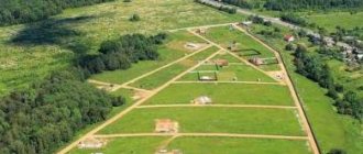
What are the grounds for deregistration of a site?
Removal of a site from cadastral registration is accompanied by changes and partial removal of current data about it from the official unified database of our country. Naturally, information entered into the register will not be deleted without a reason; legal grounds are needed:
- Initiative of the owner (for example, the plot was deregistered during division, etc.);
- Exclusion from the Unified State Register of temporary information about the site;
- Other grounds provided by law.
The plot was removed from cadastral registration at the initiative of the owner
If plots are divided, combined or redistributed, that is, other, newly created plots are formed from the original land plots, then simultaneously with registration, deregistration occurs. This is provided for by the Land Code (Article 11.2). At the same time, the owner does not need to write any additional statements to deregister the site.
There are cases when a plot is removed from the cadastral register by a court decision. This mainly happens when cadastral errors are identified in the Unified State Register of Real Estate. In this situation, the owner applies to Rosreestr with an application to remove the plot from cadastral registration, having in hand such a legal basis as a court decision.
Temporary nature of information about a land plot - what does this mean?
When the Unified State Register of Real Estate was created and replenished, information from two other sources from the State Property Register (State Real Estate Cadastre) and the Unified State Register of Real Estate Rights was transferred to it.
All information about lands and other real estate objects was merged into a single database and the newly generated data acquired the status of previously recorded ones. Along with this, the Unified State Register is constantly updated with new information, which is reflected on the public cadastral map.
Rights to some lands have still not been registered. That is, the plot is registered in the cadastral register, but the ownership of it is not properly documented, as required by law. If the copyright holder does not declare itself before March 1, 2022, information about such a site will be excluded from the Unified State Register of Real Estate, which means the site will be deregistered.
Other grounds for removing a plot from cadastral registration
In addition to those listed, there are other grounds, for example, a forest plot can be removed from the cadastral register if it turns out that it is located within the boundaries of other land plots. As a rule, this applies to the lands of agricultural settlements, the lands of which border on forest areas and overlap the forest areas in coordinates. Deregistration occurs in order to avoid such overlapping of lands on top of each other. Also, the law provides for the specifics of deregistration of sites located in the Far East.
Where can I watch it?
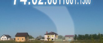
The cadastral number of any plot registered with Rosreestr refers to publicly available data entered into the state real estate cadastre.
Public information is provided at the request of citizens, and it can be obtained either in person or by online request. Let's look at each method in more detail.
How to find out online on the Rosreestr website?
Attention. On the official website of Rosreestr you can check the land plots that are registered in the cadastral register.
In order to check the site on the Rosreestr website, follow the step-by-step instructions:
- We go to the Rosreestr website (direct link - rosreestr.ru/wps/portal/online_request).
- Go to the “Online reference information on real estate” tab.
- The service offers to find data about a property using the following criteria: cadastral number of the property, conditional number or address of the property. We check based on the available data.
- If the cadastral number of the land plot is known, put a dot next to the corresponding column and enter the data.
- If there is no information about the cadastral number, the plot can be checked using the conditional number (it is indicated in the technical inventory documents or title documents).
- You can also find a plot by address; to do this, you will need to put a dot opposite the “address” column and fill in the lines opposite (how to check the cadastral number of a plot by address?).
- After the data has been entered, the system will conduct a small check: a window will appear at the bottom with text or numbers that must be entered in the field opposite.
- After making sure that the data from the image is entered correctly, click on the “generate request” button.
Important. Checking through the Rosreestr website is free, and any interested person can use the service.
To learn how to find out the cadastral number via the Internet, read this article.
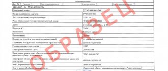
Obtaining information from the USRN extract
The Unified State Register of Real Estate provides citizens with the opportunity to check information about the owner of the land plot and obtain information about the date and registration number of the land owner.
The check can be done in two ways:
- by applying for an extract in person;
- by ordering the document online.
Let's consider both methods.
Personal appeal
An extract from the Unified State Register may be required when performing any legally significant actions with land plots and real estate. These actions include:
- buying or selling land;
- donation of land;
- exchange of land plots and other real estate transactions.
The document is drawn up on A4 paper and contains information about the property that is owned.
To order an extract from the Unified State Register, you must provide the following data to the MFC department or Rosreestr authorities:
- Applicant's passport.
- Application for an extract.
- Document confirming payment of the duty (check).
After the specialist accepts the documents, the applicant will be given a receipt confirming receipt of the request. After 5-10 working days, you can pick up the finished statement.
Attention! You can order an extract not only at the offices of the MFC and Rosreestr, but also through the State Services portal, as well as through third-party online services. The service is paid. You can receive an extract not only in person, but also via the Internet.
Ordering an extract from the Unified State Register of Real Estate
You can order an extract from the Unified State Register through the official website of Rosreestr; to do this, you must follow the step-by-step instructions:
- We go to the official website of Rosreestr (rosreestr.ru).
- Go to the “Services” tab (on the right there will be an icon in the form of a house. Click on it with the left mouse button).
- In the drop-down menu, select “Provide information from the registry.”
- You will need to enter data about the property. Here we choose the most convenient way to search for a land plot: we look for a plot by address or cadastral number. Left-click next to the found object to select it from the search results.
- We enter information about the customer, be sure to enter your email address to which the statement will be sent.
- After the necessary data has been entered, the system will offer to pay for the service: enter the bank card number, full name of the holder and pay for the service. Typically, banks require confirmation of the transaction: a secret code will be sent to the cardholder’s phone number, which must be entered into the appropriate field on the website.
- The request is generated immediately after payment.
- The extract will be ready within an hour.
This method is most convenient if you do not have time to wait for an extract in person.
In addition, the document that will be sent to the specified email will have the seal of Rosreestr and the document will have the same legal force as one received in person.
How to remove a land plot from cadastral registration
Only an authorized body, Rosreestr, can remove a land plot from cadastral registration.
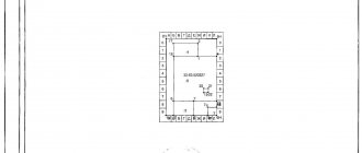
When the owner applies for the division (merger) of land plots, then the original plot (the one that is divided or combined) is removed from the cadastral register simultaneously with the registration of new plots. The division, merger or transformation of a plot is accompanied by the preparation of a boundary plan, which will be the basis for removing the original plot from cadastral registration.
Land surveying, in turn, is carried out by cadastral companies. You can select the one you need using the catalog of performers.
In the case when a land plot is removed from cadastral registration by registrars on the basis of a court decision, then cadastral registration is terminated on the basis of an application for deregistration, as well as a court decision and other supporting documents.
Clarification of difficult points
Violation of the type of permitted use of land is a difficult point to determine. In judicial practice there is no general view of such a violation, but the difference between them is huge.
In some courts, the type of permitted use of the plot is considered as compliance with the declared directives. A different approach does not consider changing the VRI as going beyond the intended purpose; accordingly, there can be no talk of legal liability.
There are a lot of contradictions in judicial practice on issues of violation of the intended use of land. Different authorities may make diametrically different decisions on the same issue. Therefore, in order for the court to always be on the side of the owner, legal scholars recommend seeking the services of competent specialists in the field of land law.
What is the difference between a site category and a RVI?
The legislation does not provide a clear interpretation of the permitted type of land use. Therefore, the concept is taken from the existing legislative framework. RVI is a characteristic of an allotment based on the zoning of territorial boundaries with a designated purpose. That is, the permitted type of use determines the functional purpose and status of land plots. For example, for the construction of multi-storey buildings.
The purpose of creating a classification of territories is to preserve the original properties of the land. The concept of “site category” has a fairly broad meaning, and RVI is of a clarifying nature. Let’s take as an example an allotment in a gardening non-profit partnership, and it will have the following characteristic data:
- Category – conducting agricultural activities.
- RVI (what you can do on the site) - plant a garden, vegetable garden.
- Basis - the land is registered as private property or rented by a specific person.
There are 3 types of permissible use of plots - main, conditionally permitted, auxiliary. The last variety is used simultaneously with the first and second types. If the use of the plot is conditionally permitted, consent will be required from the local administration. To do this, mandatory hearings are held, after which a decision will be made.
The main species are determined by the new RVI classifier. It not only streamlined the presentation of information, but also introduced new subtypes. The status of the site may be as follows: construction of garages, low-rise apartment development, higher educational institutions of various specialized levels. In addition, land is provided for equipment of meteorological services, construction of schools and kindergartens.
Instead of output
The removal of a site from cadastral registration, as well as its registration, is carried out by the registrars of Rosreestr, if there are legal grounds for this. Registrars are guided by federal legislation and also act in strict accordance with Order of the Ministry of Economic Development dated December 16, 2015 No. 943 “On the procedure for maintaining the Unified State Register of Real Estate,” which contains a list of grounds and procedures for removing a site from cadastral registration.
The plot has been removed from the cadastral register - this means that its cadastral number has been cancelled, therefore information about the boundaries and area is not reflected in the unified register. However, the archive contains information about what the land plot was like previously (its cadastral number, coordinates, etc.). This information is for informational purposes only.
Why do you need to check whether the memory is listed on the cadastre?
Important. To conclude any transaction with a land plot, a cadastral number is required.
The fact is that checking the land plot in advance will allow you to protect yourself from purchasing a plot on which the construction of residential buildings is prohibited. In addition, registering a land plot for cadastral registration allows you to:
- fully manage the land;
- survey the allotment;
- carry out the procedure of alienation of the plot to a third party.
Thus, checking the land plot is a guarantee that the owner of the land has the right to dispose of the plot , and when the plot is sold, his rights will be completely transferred to the buyer.
Features of previously recorded areas
The peculiarity of such plots is that they are not registered with Rosreestr according to the new rules. Information about them may or may not be contained in the register of immovable objects, since the information for entering them was taken from old archives and documents.
The owner of such land does not have full rights to dispose of this or that object in his ownership. He cannot sell, donate or inherit this area of land until he has registered the land according to the new rules, including the allocation of the boundaries of the site.
Features of making changes to the cadastral chamber
Now, if you need information about a specific land plot, you can simply contact Rosreestr or the MFC and issue an extract from the Unified State Register of Real Estate.
At the moment, the extract from the Unified State Register also contains cadastral information.
But a person who contacts the chamber may encounter an unpleasant situation: information about the site, which seems to have been previously accounted for and registered, will be missing. Accordingly, information about your site must be entered into the database.
Any owner can correct the situation. To do this, he will need to contact the cadastral chamber and submit an application to enter information about the land allotment. This application will need to be accompanied by:
- documents that confirm ownership or other grounds for disposal of land (for example, perpetual use);
- act of issuing land to a person;
- certificate of land title, if it was issued on the basis of the Decree of the President of the Russian Federation of October 27, 1993;
- decision on the issuance of a land plot issued by the local administration;
- long-term lease agreement;
- house book.
You do not need to attach all documents. The owner of the plot usually only has those documents that prove the legal acquisition. Confusion arises due to the fact that in different periods of modern history there were different procedures for registering rights to real estate, and at the moment, when the legislator unified the rules, repeated changes to the information bases are required.
The period for consideration of such an application is 20 calendar days. At the end of this period, updated information must be entered into the database.
Download the application for inclusion of information about a previously registered land plot (sample)
Documents required when applying to Rosreestr
When contacting the registration authority, you must provide the following list of documents:
- Statement.
- Passport.
- Certificate of ownership.
- Extract from the household ledger.
- Contract of sale or lease.
- Plan of the delineated area.
- Receipt for payment of state duty.
Change in land status
Is it possible to change the status of the land? What needs to be done to change the status of a land plot from “temporary” or “cancelled” to “registered”? Answering the first question, let’s say: “yes, you can,” but we’ll tell you below how to change the status of a land plot. So, in order to change the status of an entry in the Unified State Register of Land Registers about a land plot from “temporary” to “registered”, it is enough to register a real right to such a property. To do this, you need to submit a corresponding application to the territorial or extraterritorial (if the object is located in another region) branch of the MFC, or directly to Rosreestr (and in any of the possible ways that is most acceptable to you). The complete list of necessary documents to obtain this service can be clarified locally or on the State Services website, since it may be different in each individual situation.
to transfer a land plot from “cancelled” to “registered” than from “temporary” to “registered”. Since it will be necessary to re-prepare the boundary plan, and accordingly the application will be submitted for simultaneous cadastral registration and registration of property rights. If little time has passed and no significant changes have occurred in the legislation regarding the requirements for cadastral registration, you can contact the same cadastral engineer who was involved in the development of the boundary plan initially, with a request to make minor adjustments to the document (for a relatively small fee), and submit it to Rosreestr for repeated cadastral registration and registration. However, land legislation is one of the most unstable in our country, changes are made regularly (almost every six months), so the cadastral engineer is sometimes simply unable to meet you. In this case, you will have to start from the very beginning: collecting documents, measuring the site in situ, preparing a new boundary plan, submitting an application to Rosreestr. Well, we believe there is no point from “registered” to other statuses