- Topoplan or subbase: what's the difference?
- Stages and results of drawing up a site plan
- Our projects
- Our specialists
Specialist consultation
High-quality construction is impossible without preliminary design. In order for the project of the facility to be drawn up correctly, it is recommended to carefully study the territory for the presence of unfavorable factors. They mean not only the specifics of the relief, unstable soils, etc., but also the presence of utilities underground.
Engineering and geodetic surveys make it possible to obtain detailed information about the characteristics of a site. They include a long list of activities aimed at exploring the area of interest. One of the most common survey methods is topographic survey, upon completion of which the customer receives 2 documents:
- topographic plan of the site;
- geodetic basis.
Why carry out engineering and geodetic surveys and topographic surveys? In essence, this is a pre-project stage, in which not only large construction organizations, but also owners of private plots should be interested. The number of utilities and buildings is constantly growing. Topographic survey allows you to draw up a project in such a way as not to affect existing structures and avoid additional waste.
A site plan may be needed to achieve the following goals:
- obtaining a building permit;
- drawing up projects for construction or reconstruction;
- transfer of ownership of the formed land plot;
- landscape design;
- vertical planning.
Find out more where you can order high-quality topographic surveys in Moscow and the region!
What is it for?
- Obtaining permission to build capital structures of any type.
- Establishment of encumbrances on a plot of land or some part of it.
- Installation of engineering communications.
- Preparation of a master plan for area development.
- Registration of extensions to a plot of land.
- Landscaping.
- Identification of forest zones for the next felling, etc.
Geodetic tablet
To record information obtained during a geodetic study of the area, cadastral engineers use special tablets. They consist of whatman paper glued to a hard surface, usually aluminum or wood.
The device is convenient to use when :
- ground field work, for marking outlines, taking measurements of existing buildings on the site and for applying survey justification. To obtain accurate information about an object, a surveyor uses specialized tools, including GPS instruments and total stations;
- creating copies of existing geodetic plans;
- processing of materials obtained during land surveying, including the creation of a pencil image of the area and additional calculations.
A geodetic tablet at the stage of drawing a terrain plan looks like this:
Who can make up
The engineering topographic plan must be drawn up by surveyors who have SRO approval for the required type of work. Our company provides services for conducting topographic surveys with the following registration of the topographic plan in the authorities.
You can make a topoplan personally, but only for your own use. In the case of tasks where a diagram is added to the documentation package, it should be drawn up by surveyors, since a personally prepared document will not have legal force.
Features of compilation: Preparation requirements
The topographic plan of the site must meet the requirements. The diagram is produced on a scale that is selected depending on the purpose. Maps with a small scale do not allow you to highlight individual objects. For construction, in the vast majority of cases, plans with a scale of 1:500 or 1:1000 are used. The document may include not only a map of the area, but also additional images.
When using conventional symbols, the diagram can display the following objects and unusual features of the site:
- Relief. Depicted as horizontal lines. Those relief elements that cannot be represented by contours are marked using special symbols.
- Terrain objects that can be used as landmarks. They are depicted by off-scale signs and are precisely tied to coordinates.
- A road network depicted in detail using conventional symbols for different types of roads.
- Hydrography. Large lakes, swamps, rivers and other bodies of water are marked on topographic plans, indicating names, depths, etc.
- Soil and vegetation cover. Depicted using separate off-scale symbols and color.
- Engineering Communication. Topographic plans identify both above-ground communications and those located underground.
Inscriptions are made in certain cartographic fonts, taking into account the location rules. A stamp is provided in the lower right corner of the map, which contains all the necessary information regarding the scale, date of production and location of the depicted area.
Topographic survey is carried out using geodetic equipment, tacheometers, GLONASS/GPS equipment. Thanks to this, it is possible to obtain certain results of measuring the site plane, elevation characteristics, coordinates and other characteristics. Geodetic equipment is characterized by an excellent level of reliability, which is why it is not afraid of dust and moisture.
has its own geodetic equipment, which undergoes regular testing, which in turn allows measurements to be taken with excellent accuracy. Expert software is used to draw up topographic plans.
Reading sequence
Reading a map makes it possible to most competently and completely understand symbols and conventions, to recognize types of objects in a short time and without errors.
In addition to reading, it is important to visually perceive the relationship between objects located at a certain distance in space.
To gain such knowledge, you need to practice reading and draw out fragments with symbols. In addition, it is important to train on maps of different scales.
The following sequence is recommended for reading topographic maps and plans:
- Definition of scale.
- Search for various objects and identify their type, such as bridges, factories.
- Determining the location of communication and power lines, as well as other types of communications.
- Identification of vegetation using designations that allow one to determine the type of tree, its rarity or density, size and area occupied.
- Identification of hydrography, which includes rivers and lakes. Their characteristics are established.
- Definition of relief with its characteristics - the presence of mountains, slopes, cliffs and ravines.
- Relief detection when moving along a given route.
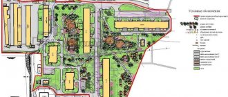
Manufactured types of topoplans
- Geobase. Compiled on a scale of 1:500. All utilities and the road network must be marked on the plan. This topographic plan must be consistent with the operating organizations.
- Horizontal shooting plan. Typically, this type of diagram does not contain information regarding terrain and elevation. Necessary for cutting land, recording a given area, etc.
- Tree plan. This plan is executed on a huge scale of 1:100 or 1:200 and is characterized by detail. The diagram can display relief, vegetation cover, water bodies, etc. The tree plan is used in landscape design and when carrying out landscaping work.
What is displayed on the topoplan
- Heights and relief. This is an important feature of the topographic plan in comparison with other types of diagrams of the required areas. The height of any point can be determined on a topographic map.
- Engineering Communication. Conventional signs depict underground and above-ground communications, engineering structures.
- Water objects. On plans with huge areas of terrain, small water bodies are not marked. The exceptions are those that can be used as a guide.
- Using the topographic plan, you can determine the location, area, configuration and boundaries of the land.
- Buildings and structures. The peak and number of storeys must be indicated. Objects for various purposes are indicated using special symbols.
- Boundaries of land plots. The diagram defines the boundaries of all land plots located on the ground.
Terrain imaging methods
Central importance on topographic maps and plans is given to relief. It is he who determines the features and character of other objects . This is a combination of uneven ground and bottom of reservoirs, as well as concave and round shapes for various purposes.
The result is a three-dimensional representation of the space in question. With developed skills in reading diagrams and symbols, you can find objects not only horizontally, but also accurately determine their height.
For clear orientation on the map, it is important to understand the depiction of reliefs.
The following is taken into account:
- What irregularities exist, how are they related to each other;
- Absolute heights of points on the ground with mutual elevation;
- Steepness, shape and length.
To decipher and correctly read topographic maps and plans, standard methods are used :
- Horizontals;
- Marks;
- Image in color and symbols.
Using a combination of methods, you can easily find the required objects and draw conclusions about their characteristics.
Horizontals
This is the main method that is used to display relief.
Other options only complement it. Irregularities are transmitted very accurately on the surface. You can display the steepness of slopes and determine the height, typical shapes and features of landscapes.
The surface is conventionally cut by planes, which are applied at equal distances .
The section height is the distance between the cutting planes. Moreover, on each of them there is a relief line. It turns out in the form of a closed curve.
It is projected horizontally. Therefore, such lines are called horizontals. They cannot intersect, since they are located in different cutting planes.
Intersecting horizontal lines are used only in cases where it is necessary to display cliffs.
With marks
They are applied at intervals of 2 cm, but much depends on the specific features. They are placed at important points of the relief. As a rule, marks are combined with significant objects. The marks of benchmarks or geodetic points are always indicated.
They are convenient because they make it easy to navigate the notations and identify the necessary objects .
Color and symbols
Color is intended to use height scales that are graduated in shades. On relief, colors are used for clarity when other methods cannot be used or when we are talking about maps on a small scale.
Stages of drawing up a topoplan
- Preparation of technical specifications . Surveyors are engaged in compiling cartographic materials based on technical specifications. All important nuances must be taken into account in the process. The list of works varies depending on what the topographic plan is needed for. The Cadastral Bureau - Real Estate company will help in preparing the technical specifications, competently drawing up the document taking into account all the facts and wishes.
- Agreement . As a rule, a topographic plan is only one document in a huge register. In addition to preparation, other work performed by surveyors and cadastral engineers is also necessary. You can order any necessary services, which will allow you to save on the preparation of technical documentation for the land plot. All services and work regulations will appear in the contract.
- Preparation . At this step, surveyors study the available materials on the object being surveyed.
- Field work . Conducted directly on site.
- Cameral stage . The data determined at the stage of field work is analyzed, then a plan is drawn up on their basis using special software. If you need a detailed topographical plan of the site, drawing work will take a lot of time. The timing of the work must be specified in the contract, and therefore you will always know when the specialists of the Cadastral Bureau - Real Estate company will complete work on the plan.
- Coordination . An inevitable step that can be carried out in person. However, if you don’t want to waste time, you can always turn to the experts.
Then you need to draw up a contract?
It often happens that a topographic plan is only one document among a large number of others. In addition to its preparation, you may also need to perform other work, which our specialists can also successfully handle. In our company you can order a full list of services, as a result of which you will save.
At this stage of work, specialists collect various information regarding the object of study. It is possible that old-style topographic maps and plans already exist. All these points are certainly taken into account.
Then they begin the actual field work. Surveyors go to the area and conduct research and measurements using high-precision equipment and technology.
At the desk stage, the obtained data is analyzed. Based on them, a plan is drawn up (special software is used). If a detailed site plan is required, this can take a lot of time. But in any case, you will be notified in advance about the deadlines for completing the topographic plan.
After preparing the information, it is agreed upon by various authorities. You can do this yourself or entrust this work to specialists.
Engineering topographical work
Before starting field work, surveyors check available materials, including:
- Extracts from the Unified State Register of Real Estate.
- Previously created cartographic materials (topographic plans, maps, diagrams, etc.).
Thanks to this data, it is possible to preliminarily find the work that will be carried out at the field stage.
Only after all this, specialists begin to work on the ground: they carry out topographical surveys of the object with the calculation of distances and peak coordinates of turning points. The resulting information will be used in calculations.
Next, desk processing of the results is performed. Experts analyze the information received and perform calculations using expert techniques and software. Once the data has been processed, the drawing of the topographic plan begins.
Drawing up a topographic plan - who can do it and how
Creating a topoplan is the job of surveyors. The engineer must have:
- appropriate education;
- membership in SRO;
- license and certificate of approval for exploration activities.
Typically, an employee works well in a company rather than alone. This provides a lot of advantages - the opportunity to use modern equipment and computer programs.
The requirement for tools is their accuracy. It must be certified annually after passing the commission. The devices are stamped with a stamp indicating successful metrological testing. Can be used:
- total station;
- optical level;
- satellite data.
Hand metric tools are also used.
After carrying out geodetic surveys on the ground, the second stage begins - drawing up a topoplan using computer programs. When choosing a company, pay attention to what software the engineers use. If it is old and unprofessional, then this may lead to the following problems and inconveniences:
- inaccuracy, errors in measurements;
- inability to export a drawing to the software that designers will use, format incompatibility;
- lack of possibility of electronic document management, which will complicate the exchange of files at the approval stage, as well as control.
The best software for surveyors is offered by . The company offers discounts for bulk orders. If you represent the interests of a geodetic company, then for several licenses you will pay less than for a similar product from other developers.
Software from ZVSOFT – CES-Topo, Geonium, ZWCAD. These are convenient, multifunctional platforms with a full range of necessary tools and functions.
When all the information has been fully processed and the plan has been created, it is given to the customer.
What to consider when ordering a topoplan
- The engineering plan will be valid for three years from the moment it was prepared. During this period of time it can be used in design or construction. After the expiration of the deadline, it will be necessary to do a fresh topographic survey.
- Saving on initial work is not always advisable. Other construction documents are prepared on its basis, and rework can entail significant costs. The cost of preparing a topographic plan varies depending on the detail and scale.
- The finished topoplan must be approved. Even the slightest mistake can lead to refusal of approval. In addition, this stage can last for an unpredictably long period. Therefore, it is better to entrust the drawing up of a topographic plan to experts who will approve the document themselves.
- The accuracy of the topoplan may depend on the quality of the equipment used by surveyors, the regularity of its checks, and the marks of the metrology service. When renting equipment, which is practiced by small organizations in order to save money, it is difficult to guarantee the accuracy of measurements. Our company uses its own equipment, and therefore by contacting us, you do not have to worry about the results.
- The final result depends almost entirely on the accuracy of the compilation, since surveyors focus on this aspect. Come to us for a consultation! Our professional will help you draw up technical specifications for topographic survey. This allows you to eliminate incorrect formulations and goals, which in turn will make it possible to avoid unnecessary costs in the future.
- It is best if the plan and other documents are drawn up in one organization, since another company will not risk taking responsibility for the fact that the remaining documents were prepared incorrectly.
How to make a topoplan yourself
If you have the necessary tools, but there is no need for an official building permit, for example, you are building a barn or a fishing house, then using software from ZWSOFT - Geonium, you can create a topographic map with your own hands, an algorithm:
- according to the outline of the topographic survey, we indicate the boundaries of the site and pickets (these are lines along the coordinates of points along the route every 100 m each, with a designation of the height on each segment);
- We put all the buildings on the diagram;
- we note the height and necessary characteristics of any object, even a fruit tree, and use graphic symbols;
- it is convenient to make several layers in the program, for example, on one - plants, on the second - buildings, on the third - communications, and so on;
- We indicate the height from sea level at each picket;
- We interpolate the data by drawing straight lines horizontally - these are the elevation lines of the site.
If you don’t need documentation, and therefore no header, fields, summary of results, then the independent work is over, you can start designing, which is also convenient to do in ZWCAD.
Geonium has a number of modules, each of which is responsible for a certain part of the tasks:
- “Topoplan” is a base for creating a map, tools and a library of symbols for a surveyor.
- "General Plan" is used to prepare the design of industrial facilities.
- “Networks” - the module is designed for laying communications, and it is convenient for a surveyor when it is necessary to mark pipes already laid on a site.
- “Routes” – for working with longitudinal linear objects.
- "Sections" is used to expand the previous block to produce a cross-sectional image.
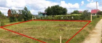
The picture shows what the topographic plan of the land plot looks like:
Appearance Features:
- It can be printed or electronic. When making approvals, obtaining permission and extracting from the cadastre, they usually use paper, stamps and signatures. In practical work, during design, a digital model is usually used.
- Different scale. The choice of research accuracy depends on the technical specifications and the volume of the site. If this is a topographic plan for one land holding, then the scaling is strong, and if the diagram is required for urban planning purposes, for example, to assess the condition of a district or block, then the scale will be smaller.
- Printing takes place on A4 or A3 sheets.
- When registering, you need a header, certain fields and compliance with all GOSTs. The CES-Topo and Geonium software takes into account all the requirements for creating a project.