Determination of the boundaries of a land plot on the ground is carried out in the order of drawing up a boundary plan for the allotment.
The need for such a procedure is caused by the requirements of regulatory legislation on cadastral activities and the provisions of the Land Code of the Russian Federation.
Land surveying is carried out when selling a plot, registering a deed of gift, or obtaining ownership rights.
Also, this procedure may be necessary when increasing the area, clarifying the boundaries, separating several parts from one whole plot or combining several into one.
Briefly about boundaries, turning points and coordinates
The boundaries of a land plot are determined using geodetic equipment. Each point has its own coordinate, which is calculated by measurements on the ground and subsequent processing of the device data.
Thus, all turning points of a land plot, whether there are 4, 5 or 10 of them, have their own digital designation and are contained in the Unified State Register of Real Estate extract.
In order to quickly find out where the boundaries of the desired area are located by coordinates, you need to order the service: “Placement of boundaries in nature” - this service is provided by geodetic and cadastral companies for a fee.
Let's consider several ways to search for the boundaries of a site by coordinates yourself, using the available data and tools.
Engineer or Internet
If it is necessary to finally determine the boundaries of the site, it is advisable to invite a cadastral engineer. This can be done by submitting a corresponding request to the cadastral chamber or by contacting a private organization that has a state license for such activities. Regardless of where the owner of the land plot applies, the service will be paid, but in this way it will be possible to find out the exact boundaries and receive a confirming official document.
The established boundaries are secured by driving in special columns on which marks are made with indelible paint.
If land surveying has been carried out previously and you need to look at the boundaries of your territory, this can be done without involving anyone from the outside, without leaving your home. All real estate objects registered in the cadastral register have an individual registration number, which is displayed on the official portal of Rosreestr. In the appropriate section, the cadastral number or exact address of the site is entered into the search line, after which you can familiarize yourself with information about it.
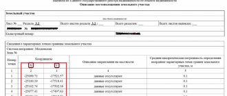
Coordinates from the USRN extract x and y
If you order an extended EGRN extract for a land plot, then in section 3.2 of the extract we will see information about the characteristic points of the boundaries of the land plot in the form of a set of numbers.
The coordinates in the Unified State Register are contained in the local system (in our example, the coordinate system is Moscow).
Is it possible to find the boundaries of the site yourself, knowing these coordinates and how to do it?
The need for land surveying
The need for differentiation is due to the fact that since January 1, 2017, a transaction related to the transfer of rights to a real estate property cannot be carried out without documents certifying registration in the cadastre.
However, there are a number of situations in which precise boundary setting is not required.
These include:
- Registration by the owner of the rights to the allotment if it was obtained through perpetual use.
- Land plots provided by the administration, the state to the owner for a specific purpose (construction: for individual housing construction, a subsidiary farm, a vegetable garden, a country house).
- The owner of the real estate already has all the title documentation in his hands.
- The owner changes the land title thanks to state and municipal lands, in the order of redistribution (giving land by the state).
It is worth noting that the dacha amnesty assumes that the possibility of registration without specifying the exact limits of the territory is preserved only in situations where the owner increases his allotment through the redistribution of state property. and municipal lands and in cases where the land plot was transferred from the state, local self-government bodies to the citizen.
Through land surveying, the object is registered in the Unified State Register of Real Estate, after which it is automatically entered into the cadastre and registered. This provides the opportunity to increase or decrease the territory.
Please note: changes in the boundaries, size of the plot, or in other words, the correction should not exceed 10% of the area of the plot, which is listed in the Unified State Register of Real Estate in accordance with Federal Law No. 221, clause 3 of Art. 42.8.
Download Federal Law No. 221 On cadastral activities (1.4 MiB, 374 hits)
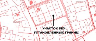
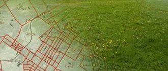
How to find a site by xy coordinates on a map
If you have data from a local coordinate system, then most likely you received it from an extract, which means you have a cadastral number for the land plot. Using the cadastral number, it is easy to determine where exactly the plot is located - you just need to enter it into the search engine of the public cadastral map and you will see not only the location of the land plot, but also its description (address, category of land, cadastral value, area, etc.)
But, if you only have coordinates, then the situation is more complicated.
To find a site using X, Y coordinates, they should be converted to geographic coordinates. To do this, there are a lot of free and paid services for converting coordinates from one system to another on the Internet.
However, keep in mind that the recalculation (especially the free one) will be approximate and the data of such coordinates may have a range of plus or minus a couple of meters, or even more.
If you have the cadastral number of the plot, then you can find its geographical coordinates on the same public page - we wrote detailed instructions on how to do this in a separate article.
In short, move the cursor over the corner of the land plot of interest and click the mouse - the search engine will display the geographical coordinates. See photo below.
If inconsistencies are found?
When the owner of a plot of land discovers any errors in his documents that are not related to typos, but rather incorrect information, or these errors are contained in the unified state cadastral database, they should be eliminated immediately.
This is done by submitting an application and documents to the cadastral authority. When we are not talking about mechanical errors, it will take more time and money, since the surveying procedure will need to be done again. Other specialists are involved, a geodetic survey is carried out, and new documents are drawn up, without errors.
Correcting a cadastral registration error is also considered necessary if the layout of the property according to the documents differs from the existing layout in the unified state database, on the basis of which the title documents are issued. It is worth keeping in mind that the recording and correction by the hand of a cadastral engineer on a document about an identified error does not constitute its correction or justification of the existing boundaries of the territory. The boundary plan will have to be redone and the data entered into the cadastral registration database.
How to determine the coordinates of a plot of land using a smartphone
We have all been using GPS navigation for a long time. However, it is worth understanding that telephones operate on a simplified system and do not always reflect the area as it really is. Surely you have encountered at least once the fact that the navigator periodically “goes stupid” and gets lost on the road. The same thing happens when you try to find the desired coordinate on the ground.
In phones, cell towers are usually used to improve accuracy; in fact, this leads to an error of several meters. Of course, if the plot measures tens of hectares, then this deviation is negligible, but if you want to know the area or boundaries of a plot of 5-6 acres, then the difference in fact will be colossal.
If you still decide to use your phone and use it to determine the coordinates, then use a navigation program - save or write down the geographic coordinates of each point on the ground, and then using these coordinates, find the location of the site on the public cadastral map and make sure whether the actual boundaries coincide with borders of the map.
In what situations is it necessary?
The need to find out the exact boundaries of your land arises in situations such as:
- Dividing the territory into two separate real estate objects or more, as well as combining several into one;
- Determination of the shares of co-owners during inheritance or division of property;
- Registration of a land plot for cadastral registration for the first time;
- Clarification of the location and exact boundaries when selling the territory;
- The presence of a cadastral error in documents or the unified state registration database;
- Clarification of the boundaries of several plots of land at once.
A land survey plan can be drawn up only on the basis of the information contained in the cadastral plan and information entered into the unified cadastre database.
When it is necessary to make a new boundary plan, sometimes cartographic materials are used, along with land management documents from the archive. However, as practice shows, quite often the cause is precisely conflicts due to the unauthorized seizure of someone else’s share of land. Either the owner mistakenly grabbed someone else’s property, or the neighbor went beyond his boundaries and uses someone else’s property, convincing him that it belongs to him.
Who determines and measures the boundaries of the site for apartment buildings
This function is regulated by the current laws of the Russian Federation. In particular, the Town Planning, Land and Housing Codes. The area is designated in accordance with the actual land use, taking into account the urban planning rules in a particular region. Factors that influence the allocation of a zone for an apartment building:
- Adjacent territories.
- Natural conditions.
- Engineering Communication.
- Other stationary facilities located in the area.
The following parameters are also taken into account:
- Density of buildings in the area.
- Roads and access roads.
- House area.
- Number of storeys.
- Number of residents.
It is possible to carry out such work only with the consent of the majority of all residents of the apartment building. This is a long and difficult process. The first step at the general meeting is to draw up minutes and collect signatures. Next, a responsible representative of the team is selected. He submits an application for the formation of a home ownership to the regulatory authorities. The next step will be to develop a plan (map) and agree on all the details. If land surveying has not been carried out, then initiation of this procedure is required. And only after all these points can the land be registered as common shared ownership.
How to determine the boundaries of a site on the ground, what to do if they are violated
If you suspect incorrect designation of coordinates, you should contact the cadastral service and order a land surveying service. As a result, changes can be agreed upon and the agreement between the owners documented. If a compromise is impossible, then all issues are resolved in court. To defend your interests you may need:
- Documentation of ownership.
- Plan diagram.
- Indicating the location of the fence.
- Results of geodetic research.
- Certificate of approval (if available).
Eyewitness testimony may also be helpful. For example, if you claim that a neighbor unauthorizedly erected a fence in the wrong place.
Coordination of changes
It is not always possible to obtain the consent of all neighbors to register a plan. Therefore, in case of disagreement, we advise you to proceed as follows:
- Agree with surveyors about measurements.
- Notify all neighboring owners in writing about the date of measurements (one month before the appointed time).
- As a result, you receive an approval act.
- If someone does not show up or disputes the document on the spot, contact specialized lawyers with these papers.
It is always better to reach an agreement peacefully, but sometimes this is simply impossible to do. To assert your legal rights, you may have to go to court.
Why do you need an agreement?
This paper will confirm the agreements reached on the establishment of boundary lines between the participants in the process. Also, without this investment, the survey work will be considered incomplete, and further processing will simply be impossible.
When to clarify
The discrepancy between the documentary and actual state of affairs is eliminated using this procedure. The reasons may be as follows:
- There is no data on the location of the memory.
- There are no clear markers for the position of turning points.
- Disagreements with neighbors.
- The need to carry out a transaction of purchase, sale, division, merger.