14.09.2018
Arina Zakharenkova
Legal Advisor at IPT Group
Recently, many land users are faced with the problem of shifting the coordinates of characteristic points of the boundaries of their land plots. Some discover that their properties are located on neighboring plots of land, or even on a different street. Errors can reach hundreds of meters.
Need advice on a topic?
To get a consultation
For example, in the Rostov region, due to a shift in coordinates in a supposedly “free” zone, a new land plot was formed, which on the ground turned out to be included within the boundaries of the previously formed land plot. The dispute between the owners has been pending in court for almost three years, and both sides are suffering large financial losses. Another example: in the Leningrad region, as a result of incorrect determination of coordinates, a plot of 11,000 square meters. m left the lands of undelimited state property, and the local government lost the right to dispose of it. As a result, citizens who could receive the hectares due to them for use cannot exercise their right.
This problem creates reasons for acute conflicts and lengthy proceedings between land users; there are risks of land seizure and various fraudulent schemes to seize it from the owners.
Recalculation of coordinates
Experts note that this situation is often caused by the translation of the description of the location of a land plot from the old coordinate system to a modern unified coordinate system.
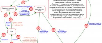
Problems associated with the presence of various coordinate systems (including conditional ones), as well as with the recalculation of the coordinates of characteristic points of cadastral division boundaries and information from the state real estate cadastre, including the lack of necessary transition parameters (keys), were addressed in a letter from the Federal State Registration Service , cadastre and cartography dated April 19, 2016 N 19-ref/05229-em/16, in connection with which cadastral engineers and Rosreestr authorities were given appropriate recommendations on how to identify and eliminate them. In the legal field, this situation is called a cadastral (registry) error, the concept and method of resolution of which is contained in Article 61 of the Federal Law “On State Registration of Real Estate”. According to Part 3 of this article, a registry error is subject to correction by decision of the state registrar of rights within five working days from the date of receipt of documents, including in the order of information interaction, indicating the presence of registry errors and containing the information necessary for their correction, or on the basis of the entered into the legal force of a court decision to correct a registry error. It is especially noted that the correction of a registry error is carried out if such a correction does not entail the termination, emergence, or transfer of the registered right to the property. If correction of a registry error may cause harm or violate the legitimate interests of copyright holders or third parties, such correction is made only by court decision (Part 4 of Article 61 of the Federal Law “On State Registration of Real Estate”).
Thus, the land user can initiate the correction of the cadastral error and provide the registration authorities with a boundary plan with updated coordinates of the land plot.
How and why to clarify the boundaries of a land plot? What documents will be useful when clarifying the boundaries of the old site? How to harmonize results in a difficult epidemiological situation? Experts from the Federal Cadastral Chamber answered these and other questions.
1. What is a property boundary?
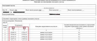
A description of the location of the boundaries of a land plot is one of the basic information that allows us to define a land plot as an individually defined thing. The location of the boundaries of the land plot is displayed in the graphic part of the boundary plan. In addition, the boundaries of the land plot can be established on the ground. The location of the boundaries of the land plot is established by determining the coordinates of the characteristic points of such boundaries.
2. What is land surveying?
Land surveying is a complex of engineering and geodetic work to establish the boundaries of a land plot on the ground. Land surveying is carried out by a cadastral engineer, who establishes the location of the boundaries of the land plot, determines its area, coordinates the location of the boundaries of adjacent plots with neighbors and prepares a boundary plan.
3. Why clarify the boundaries of the land plot?
Precisely defined boundaries of a plot of land can provide protection against legal problems that may arise with the land. For example, from disputes with neighbors over the boundaries of a land plot, as well as unauthorized construction of real estate on such a plot of land. Also, the presence of boundaries of a land plot makes it possible to carry out any operations and transactions with the plot without problems, for example, it will be easier to sell it, because it is unlikely that buyers will want to purchase a plot without clear boundaries.
Clarifying the boundaries will help correct possible errors, including in information about the actual area used. It may differ from what is indicated in the USRN information. And erroneous information about the area of a plot can cause an incorrect determination of its cadastral value and, as a consequence, an incorrect determination of the amount of land tax.
If you decide to divide a land plot, such a division is possible only if there are established boundaries of the existing land plot.
4. How can I find out what information about a land plot is included in the Unified State Register of Real Estate?
All the necessary information is contained in the extract from the Unified State Register of Real Estate about the main characteristics and registered rights to the property.
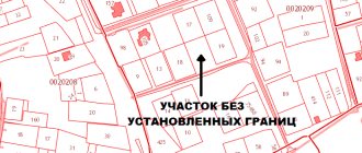
If the register does not contain the necessary information about the boundaries, the extract will contain a special o. The area of such a plot will be indicated in an integer - the same as in the title document.
If the coordinates of the characteristic points of the boundaries of a land plot contained in the Unified State Register are determined with an accuracy not lower than the standard accuracy of determining coordinates for lands of a certain purpose, clarification of the location of the boundaries of the land plot is not required, except if the Unified State Register of Information about the location of the boundaries of the land plot contains a registry error.
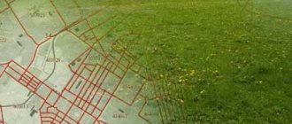
You can also use the “Public Cadastral Map” reference service. The easiest way to find a specific plot of land on it is by address. If in the object description window there is o or the area is indicated as declared, then the location of the boundaries needs to be clarified.
Important! When accessing the cadastral map, be careful: the service has duplicate sites that may present information that does not correspond to reality. The public cadastral map is located at: pkk.rosreestr.ru.
You can submit a paper request for an extract in person by contacting the Multifunctional Center (MFC) or the Cadastral Chamber. To obtain USRN information remotely, you can use the service of the Federal Cadastral Chamber, which allows you to receive an extract within a few minutes, or the official portal of Rosreestr. The electronic statement is certified by an enhanced electronic signature.
5. How to clarify the boundaries of the site?
Clarifying the location of boundaries is a whole range of work that can only be carried out by a specialist who has the right to carry out cadastral activities (cadastral engineer). Therefore, first of all, the owner needs to contact a cadastral engineer to carry out the necessary work. You can get acquainted with information about current cadastral engineers through the “State Register of Cadastral Engineers” service. When choosing a cadastral engineer, you should pay attention to his experience, quality and timing of cadastral work.
A cadastral engineer visits the site and takes the necessary measurements. If there is a fence, then measurements are taken along it. If there is no fence, it is better to mark the corners of the area with pegs in advance. The next stage is familiarization with the measurement results. Next is the process of coordinating boundaries with the owners of adjacent plots. After this, the cadastral engineer submits a package of documents to the rights registration authority.
When forming the border, he must comply with a number of rules: for example, the border of a land plot should not cross the boundaries of settlements or municipalities; the border should not cross the border of adjacent plots.
The result is the preparation of a boundary plan containing information about the coordinates of the boundaries of the land plot.
6. What documents are needed?
A cadastral engineer will not be able to establish the boundaries of a land plot just the way the owner wants. To carry out the work, among other things, he will need documentary evidence that the site has been allocated in this particular location and in this exact area.
According to current legislation, clarification of the boundaries of a land plot is carried out on the basis of information contained in the title document for the land plot.
Additionally, information specified in the documents that determined the location of the boundaries of the site when it was formed can be used.
If there are none, the clarification can be carried out in accordance with the boundaries that have existed on the ground for 15 years or more and are fixed using natural objects or objects of artificial origin, which make it possible to determine the location of the boundaries of the site.
Additional clarifications were provided by the Real Estate Department of the Ministry of Economic Development. Documents defining the location of the boundaries of a land plot during its formation and their existence for 15 years or more may be:
· Situational plans contained in technical passports of real estate objects (located on a land plot), which are prepared by the bodies of state technical accounting and technical inventory (BTI).
· Forest management materials, planning and cartographic materials available in regional authorities of architecture, construction and housing, and local authorities.
· Documents on territorial planning of municipalities.
· Projects for the organization and development of the territory of dacha, garden and vegetable garden non-profit partnerships.
Important: documents must comply with the requirements of the legislation in force at the place of publication of the document and at the time of publication.
7. How to coordinate the boundaries of the site with the neighbors?
It is not enough to clarify the location of the boundaries of the plot - it is necessary to coordinate it with the rights holders of adjacent, that is, neighboring plots. The cadastral engineer must send them relevant notices by postal or email. If they cannot be found, the cadastral engineer publishes a notice in the local press. The addressee will be considered notified even if he does not read this announcement.
Rights holders of adjacent plots must confirm their consent by signing an agreement document. In case of insurmountable disagreements, a written objection must be submitted to the cadastral engineer. It must be recorded in the approval act and also attached to the boundary plan.
If there are justified objections, the rights registration authority will suspend registration and registration activities, and neighbors will have to resolve disagreements in court. The cadastral engineer who carried out the land survey may also be involved in the case as a third party.
Resolving a land dispute at the stage of boundary approval will eliminate the need to go to court. Litigation regarding the establishment of land boundaries is one of the most complex and lengthy.
8. Is it possible to coordinate the boundaries of land plots during a difficult epidemiological situation?
The current legislation does not provide for any specific features of the border approval procedure. The cadastral engineer, at his choice, can carry out coordination either individually with each neighbor or by holding a meeting with their participation. Moreover, if it is impossible to carry out coordination on an individual basis for some reason, the cadastral engineer can, in the notice of the meeting, set a specific time for each interested party.
During the approval procedure during a difficult epidemiological situation, it is necessary to maintain social distance and use personal protective equipment.
Documents for making changes to the state register of real estate information can be submitted through the MFC, using electronic services on the Rosreestr website, sent by mail to the regional department of the rights registration authority, or use the field service of the Cadastral Chamber.
How to resolve the error
An appeal to correct the error must be preceded by a lot of work to study the real and nominal boundaries of adjacent land plots with the involvement of competent lawyers and cadastral engineers who would help find the optimal and least expensive algorithm for solving the problem.
Thus, a shift in the coordinate system of the boundaries of one land plot may lead to its overlap with the boundaries of an adjacent one, as a result of which the coordinates of the latter will also have to be clarified, and so on. That is, the initiative of one land user often affects the interests of all neighbors and problems grow like a snowball. Thus, as a result of recalculation of coordinates in the Novosibirsk region, a citizen’s land plot turned out to be located within the boundaries of different municipalities, which is unacceptable in accordance with paragraph 2 of Article 83 of the Land Code. This problem created obstacles for the local government in exercising its powers to establish the boundaries of the settlement. To get out of the situation, it was necessary to obtain the consent of the owner to correct the registry error, and subsequently to divide the land plot owned by him into two new ones with their boundaries located on the territory of different municipalities, to which the owner objected. The division was achieved only on the basis of a court decision.
Obviously, the work of making changes to information about the coordinates of several adjacent land plots is lengthy and costly: in addition to the cadastral work already carried out by the applicant, a forensic land survey, legal assistance, payment of state fees, and so on may be required. The question arises, who bears these costs?
Determination of the coordinates of characteristic points of the boundaries of the land plot
In the Russian Federation, activities to establish the location of a site and determine the coordinates of characteristic boundaries are carried out by cadastral engineers.
A cadastral engineer must have a valid professional qualification certificate, and also be a member of one of the self-regulatory organizations (SRO) in the field of cadastral activities.
The process of establishing the coordinates of characteristic boundary points is carried out within the framework of a contract concluded between the engineer (the organization in which the engineer works) and the customer.
The direct work of the boundary-determination engineer is to carry out geodetic activities and record the obtained data on maps and diagrams. The cadastral engineer also draws up a detailed description of the coordinates of the site boundaries in text form.
Who pays?
M. S. Tolstykh points out that as a defendant in a claim to correct a cadastral error in the form of intersection (overlapping) of plot boundaries, the copyright holder of a previously formed land plot with the boundaries of which an intersection has been identified should be involved, and the cadastral registration body should be involved in the consideration of the case as a third party faces.
The cadastral chamber is not the proper defendant in the case, since it is not responsible for the reliability of information, including the coordinates of the turning points of the land plot, submitted for cadastral registration. This position is also supported by judicial practice. Although the owner of the adjacent land plot is brought in as a defendant in court, however, it cannot be his fault for the occurrence of a cadastral error, because he uses the plot within the established boundaries and has title documents. In fact, he only refuses to agree on the change in coordinates, otherwise the boundaries of his site will also shift, and the area may decrease.
In some cases, claims are addressed to cadastral engineers. Part 2 of Article 29.2 of the Federal Law “On the State Real Estate Cadastre” stipulates that losses caused by the actions (inaction) of a cadastral engineer to the customer of cadastral work and (or) third parties are subject to compensation through insurance compensation under the contract of compulsory civil liability insurance of the cadastral engineer. However, it is difficult to prove the existence of a cause-and-effect relationship between the actions of the cadastral engineer in preparing the boundary plan and the costs incurred by the land user to correct the cadastral error - there is practically no positive judicial practice for collecting losses from cadastral engineers.
Thus, the costs of correcting cadastral errors are entirely borne by the owners of land plots in respect of which the Unified State Register contains incorrect information, which is by no means fair. Many authors talk about the problem of the absence of a person to whom claims can be made for the recovery of losses due to the presence of a cadastral error in the Unified State Register of Real Estate. So, Kazanchev I.T. and Dvortsov V.E. indicate the need for a deeper and more systematic regulation of issues of civil liability of cadastral engineers, Antropov D.V. and Skachkova D.I. They also consider it necessary to strengthen the responsibility of cadastral engineers and government bodies for cadastral errors.
Ways to define boundaries
There are several ways to define boundaries:
- On one's own . If the boundaries have not changed and the neighbors from adjacent areas are happy with everything, then it is possible to leave the boundaries that were before. This most often applies to SNT sections.
- Coordination with neighbors . It is one of the elements of land surveying. But if you agree with your neighbors on the boundaries and jointly sign the deed, then no additional documents will be required. This will save a lot of time.
- Land surveying . A cadastral engineer or land surveyor will mark the boundaries of your site with pegs.
- Online . Using Rosreestr data, it is possible to obtain a site plan.
Everyone chooses the most acceptable method for themselves.
Complex cadastral works
I believe that the most correct and effective way to correct massive cadastral errors caused by a change in the coordinate system can be comprehensive cadastral work provided for in Chapter 4.1 of the Federal Law “On Cadastral Activities”.
Unfortunately, legal science does not pay enough attention to this institute. Meanwhile, as stated in Part 2 of Article 42.1 of the Federal Law “On Cadastral Activities”, as a result of complex cadastral work, the location of the boundaries of land plots is clarified and registration errors in information about the location of the boundaries of real estate are corrected. The customer for complex cadastral work is the authorized local government body of a municipal district or urban district. Financing for the implementation of complex cadastral works is carried out from the budgets of the constituent entities of the Russian Federation and (or) the budgets of municipal districts, city districts, including from funds allocated to the budgets of the constituent entities of the Russian Federation in the form of subsidies from the federal budget (Article 42.2 of the Federal Law “On cadastral activities"). Thus, comprehensive cadastral work relieves the financial burden from owners of land plots for which the Unified State Register contains incorrect information.
However, the official website of the unified procurement information system contains about ten procurements, the subject of which are complex cadastral works. According to the procurement documentation, the contract price can be about 450,000 - 3,700,000 rubles, and the cost of cadastral work for one land plot is 2,500 - 6,100 rubles. It is clear that, given the widespread lack of budgetary funds, carrying out cadastral work at the expense of local budgets is not a priority; however, similar work costs private individuals five to ten times more. I believe that in the current situation, it is complex cadastral work that should become the main way to correct cadastral errors caused by a change in the coordinate system.
In the meantime, this tool is rarely used by local authorities, land users who are faced with the described problem can be recommended to solve it at the pre-trial stage, to achieve what they want through negotiations with the involvement of consultants and other specialists, without exacerbating the conflict: court proceedings on disputes over the boundaries of land plots, as shown higher, often turn out to be lengthy and much more costly than one might expect at the beginning.
Kinds
When considering the concept of cadastral boundaries, in this case, two concepts are actually used that are somewhat different from each other - the cadastral boundary and the actual one.
Cadastral
The concept of a cadastral boundary can be called an official or documentary definition.
That is, this is the line that runs between the coordinates of the points determined by the cadastral engineer when drawing up the boundary plan.
In turn, the cadastral boundary is divided into two separate definitions - declared and geodetic .
At the same time, those declared can only be of an approximate nature and are practically not taken as a basis for establishing boundaries.
Geodesics contain exact coordinates and geodetic points.
Actual
Actual boundaries mean those lines that are drawn directly at the location of the plots.
Boundaries are drawn onto the area during the process of drawing up a boundary plan, when a cadastral engineer goes to the area and, after carrying out the approval procedure, establishes the turning points of the plot.
Subsequently, a line drawn between them forms a closed-type contour , which will act as the actual border.
The concept of brokenness
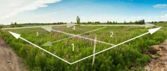
Fracture is understood as the specific placement of turning points of an allotment, which is formed by the existing adjacent allotments, the specifics of the existing soils, as well as the conditions of the relief and landscape of the area.
Ideally, the site should have only 4 characteristic points and, as a consequence, 4 boundaries. In practice, land plots are not always presented in this form, and the more such turning points there are, the more irregular the plot boundary becomes.
High irregularity significantly complicates geodetic, cartographic and topographical work.
In this regard, engineers, when determining the boundaries of the site, try to achieve minimal fracture (as far as possible in a particular situation).
What to do in case of intersection?
The intersection of plot boundaries means their displacement in any direction, while the boundaries of the plot directly intersect .
Such cases may occur when errors occur in drawing up a boundary plan for one of the neighboring areas, or both at the same time.
In addition, such cases arise when the territory is squatted, unauthorized movement and displacement of the boundaries of the site under the influence of third-party factors.
If such errors are detected, the site owner must perform the following actions :
- Contact Rosreestr with an application to clarify the boundaries (if such a situation occurs after entering information on both sections into Rosreestr);
- Agree on the location of the boundaries of the site, if such a situation arose during the formation of the boundary plan. In this case, a similar action can be performed by a cadastral engineer;
- If it is impossible to solve the problem of crossing boundaries peacefully, file a claim in court to establish the actual boundaries and eliminate all inaccuracies or consequences of illegal actions of land owners.
Requirements for boundaries
In the process of forming a boundary and establishing turning or characteristic points, the cadastral engineer must take into account the requirements that it must meet.
So, you will need to follow the following rules :
- The boundaries of the allotment should not intersect with any territorial boundaries of municipal settlements or settlements;
- The contour of the plot (border of the allotment) should be as simple . That is, the ideal shape is a quadrilateral. Of course, due to natural characteristics, configurations of neighboring areas and other factors, it is not always possible to achieve minimal fracture;
- The contour of the site should not intersect adjacent plots . In such a situation, one section will overlap another (partially or even completely);
- The boundaries must be determined in such a way that the site has access to the roadway and all communications passing in the area are accessible to it.