What is the document for?
All land plots registered in the cadastral register must have documented, strictly defined boundaries. This allows territory owners and supervisory agencies to have a clear idea of their size.
In the future, such data will help avoid disagreements with the owners of neighboring plots and state administrative institutions.
In addition, on their basis, tax payments to land owners are calculated correctly and without errors.
Cost of services
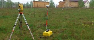
You need to understand that defining boundaries is a whole complex of work. Specialists with special equipment go to the site. Naturally, you will have to pay for these services. Practice shows that many geodetic companies do not charge fees for any individual services. It’s just that a standard fee is charged for the entire range of work. Today its size is 5-7 thousand rubles. Certain factors influence the cost:
- the status of the company you are contacting;
- locality;
- what category does the land belong to;
- area and shape of the site.
However, you need to understand that the fixed cost is taken only for standard rectangular plots. As a rule, their size is 8-10 acres. Typically, such areas are used for summer cottages. If the plot is too large you will have to pay extra. You also need to take into account that if the land has a complex shape, payment will be calculated based on the number of turns of the boundaries.
There are lands that belong to the elite category. This applies to territories located near Moscow and St. Petersburg. Here the cost of measurements is calculated separately. Practice shows that the cost of geodetic work in these regions is more than 30 thousand rubles.
Who is entrusted with the function of clarifying the boundaries of land zones
The responsibility for monitoring the extreme points of land plots is assigned to cadastral engineers. These are highly qualified specialists who have the necessary professional knowledge and have the appropriate government certificates.
The list of powers of cadastral engineers includes:
- the right to familiarize yourself with documents certifying the identity of land owners;
- the right to inspect title papers;
- the opportunity to provide land owners with a boundary plan and give the necessary explanations on it;
- establish the boundaries of land plots subject to approval;
- carry out the actual coordination activities.
How is land surveying carried out?
This procedure is carried out in several stages:
- first of all, information about a certain territory is collected and its thorough analysis is carried out;
- interested land users are notified about upcoming work;
- coordination of land boundaries with the owners of adjacent plots;
- geodetic survey;
- formation of a boundary plan;
- submission of materials to Rosreestr for registration of a cadastral passport.
Attention! The relevant work can only be carried out by specialized land management organizations or cadastral engineers. Moreover, the company must have a license, and the engineer must pass certification.
How does approval take place?
The process of coordinating the extreme points of the sites can be carried out in one of two options. The first implies that the stakeholders are several people at once. The second involves individual coordination with one neighbor.
A corresponding notification is sent to each of the parties directly related to the case a month before the event. It must be handed over only against signature.
Electronic notification or publication in the media is also permitted. True, these two methods do not guarantee that the information will reach the recipient.
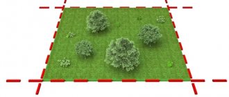
On the appointed day, the cadastral engineer takes measurements of the plots and installs special identification poles at the required points. They must contain information about the number and date of installation. Supervision over the condition of these pillars rests with the land owners. In case of damage or loss, the violator may be subject to administrative punishment in the form of a fine.
The entire process is recorded in a special approval act. This also includes information about whether the participants in the process agree with the established boundaries or not.
What's new in law 221
Coordination of the boundaries of a land plot with neighbors according to the new law 221 (as amended on August 2, 2019) is mandatory for all territories where, for various reasons, the dividing line is unclear. The main shortcomings due to which there is a need for clarification:
- the owners agreed verbally, without drawing up official documents;
- the owner of the disputed territory has been absent for a long time and part of his land is used by neighbors;
- during the previous survey there were technical inaccuracies;
- the land passes to the new owner, he must know the actual plan and boundaries;
- two sections are combined or one needs to be divided into several.
In all these cases, it is necessary to coordinate the boundaries according to the new law.
Features of drawing up an act
Today there is no generally applicable, standard form for the act of agreeing on the boundaries of a land plot, so it can be written in any form. The only thing that needs to be taken into account is that the sequence of its content meets certain standards for compiling this kind of documentation. This means that the form should be divided into three parts:
- beginning is the name and number of the document;
- main section - information about the site, the boundaries of which are being agreed upon;
- conclusion - the decision made (whether they were agreed upon or not) and the signatures of the parties.
The act can be written manually or typed on a computer. For a printed document, an ordinary blank sheet of paper of any convenient format is suitable (A4 is mainly used).
The document must be made in a number of copies equal to the participants in the approval procedure - one for each interested party.
In accordance with paragraph 7 of Art. 39 of Federal Law No. 221-FZ of July 24, 2007 “On Cadastral Activities” (hereinafter referred to as the Law on Cadastral Activities), as well as Art. 43 of Federal Law No. 218-FZ of July 13, 2015 “On State Registration of Real Estate”, approval of the location of boundaries at the choice of a cadastral engineer is carried out through a meeting of interested parties or individual approval with an interested party.
Both of these methods of agreeing on the location of boundaries require the mandatory participation of interested parties. Regardless of the method chosen by the cadastral engineer, the owner of the plot needs to pay attention to the following. When agreeing on the location of boundaries, it is important to make sure that the adjacent land user is really an interested party in the concept of the Law on Cadastral Activity, that is, he owns a land plot on one of the four above grounds. To do this, it is necessary to check the documents - the grounds for the emergence of the right of the adjacent land user. It is also worth remembering that the actual boundaries of the land plot may not correspond to the existing documents or legal boundaries (entered in the Unified State Register). Here are the main controversial situations that may arise at the stage of agreeing on the location of the boundaries of land plots: the land plot of an adjacent land user does not have established coordinates, and from the available documents it is not possible to determine the location of its boundaries; according to the documents, the land plots are not adjacent (for example, according to the general plan of the DNP, a road passes between the land plots); the location of the adjacent land user is unknown; the adjacent land user refuses to sign the Agreement. As a rule, the identification of the owner of the adjacent plot is carried out by a cadastral engineer involved in carrying out cadastral work. Still, we recommend checking the information received from the cadastral engineer. Otherwise, there is a risk of agreeing on the location of the boundaries with a person who is not an interested party (the owner of an adjacent land plot), which may subsequently lead to legal land disputes. Despite the fact that many land plots are not properly registered by the state and are not registered in the cadastral register, their disposal and approval is carried out by the relevant government body (local government) in accordance with Art. 3.3 of the Federal Law of October 25, 2001 No. 137-FZ “On the entry into force of the Land Code of the Russian Federation.” Let’s assume that a land plot is adjacent to lands that have no boundaries or cadastral number (for example, a road). In this case, it is possible to coordinate the location of the boundaries with the state authority (local government) of the relevant entity within which the land plot is located. In the case where the owner of the adjacent land plot (lands) is unknown, you can contact the Administration of the subject (district, settlement) or the board of a non-profit association for information, if the land plot is located within the boundaries of a horticultural, gardening, dacha non-profit association. If an adjacent land user refuses to agree on the location of boundaries on the basis of clause 1 of Art. 64 of the RF Land Code, the dispute is subject to judicial review. Coordination of boundaries through publication in official sources When carrying out cadastral work, it may turn out that the Unified State Register of Real Estate does not contain information about the email address or postal address of the interested person, or the cadastral engineer has received a notice of a meeting to coordinate the location of boundaries, sent to the interested person by mail shipment, with a note indicating the impossibility of its delivery. In this case, a notice of a meeting to agree on the location of boundaries may be published in the manner established for the official publication of municipal legal acts and other official information of the relevant municipality (clause 8 of Article 39 of the Law on Cadastral Activity). Typically, this means publishing the meeting in the municipal newspaper. If interested persons do not appear at the meeting, the location of the boundary with such persons is considered to be agreed upon. In this case, the cadastral engineer includes in the boundary plan the corresponding page of the printed publication with a publication about holding a meeting of interested parties. Thus, a sufficient condition for publishing a notice of a meeting of interested parties in a printed publication is the absence of information about the address of the interested party in the Unified State Register of Real Estate. Taking into account the fact that information about the addresses of interested parties in the Unified State Register is absent in the vast majority of cases, and printed publications of municipalities, for objective reasons, are not studied by the majority of residents of municipalities, the possibility of abuse of rights arises. For example, the owner of a land plot is in conflict with an adjacent land user. During cadastral work, the owner of the land plot learns that there is no information about the address of the adjacent land user in the Unified State Register of Real Estate. Since a conflict may become the basis for the refusal of an adjacent land user to sign the Boundary Location Agreement, the cadastral engineer publishes information about the meeting in a printed publication. The adjacent land user does not familiarize himself with the specified printed publication; as a result, part of his territory may actually be captured, and formally the location of the adjacent border of the land plots will be considered agreed upon. The courts recognize that such approval through publication in a printed publication is appropriate (see box “Judicial practice”). In order to stop possible actions of unscrupulous adjacent land users to agree on the location of boundaries by publishing a notice of a meeting of interested parties in a printed publication, the copyright holder needs to clarify whether the Unified State Register of Real Estate contains information about the postal address and email address in relation to a specific land plot, and enter them if necessary . First of all, this situation concerns persons whose location of land boundaries has not been established in accordance with the requirements of current legislation (land plots are “uncoordinated”). There are also other cases in which it is permissible to publish a notice of a meeting in the manner established for the official publication of municipal legal acts of the relevant municipality, but these cases are not very common in practice (clause 8 of Article 39 of the Law on Cadastral Activities): adjacent land the site is located within the territory of a horticultural, gardening or dacha non-profit association and belongs to common property, or is part of agricultural land and is owned by more than five persons, or is part of the common property of the owners of premises in an apartment building; land plots in respect of which cadastral work is carried out are forest plots. How can the owner of a land plot protect himself if an adjacent land user applies to sign a Boundary Location Coordination Act? According to paragraph 4 of Art. 40 of the Law on Cadastral Activities, if the location of the relevant boundaries of land plots is not agreed upon by the interested person or his representative and such person or his representative has submitted in writing objections to this approval with justification for the refusal, entries about the content of these objections are made in the act of agreeing on the location of the boundaries . Objections submitted in writing are attached to the boundary plan and are an integral part of it. In accordance with clause 87 of Order No. 921 of the Ministry of Economic Development, if a duly notified interested party or his representative submitted in writing within the prescribed period reasonable objections about the location of the boundaries of the land plot, the content of such objections is indicated by the cadastral engineer in the Approval Certificate. Objections submitted in writing are included in the Appendix. If there are justified objections to the location of the boundaries, such objections must be removed either by changing the location of the boundaries and re-coordinating the location of the boundaries (a separate characteristic point or part of the boundaries), or in the manner prescribed by the legislation of the Russian Federation for resolving land disputes. Thus, the legislator provides for the possibility of filing objections in case of disagreement with the proposed location of the common border of a land plot with an adjacent land user. The law also stipulates that objections must be justified. It is important that objections are submitted to the cadastral engineer in an official manner: either in person, with a mark and signature of the cadastral engineer on receipt, or sent by registered mail with a list of the attachment to the postal address of the cadastral engineer. Despite the fact that such a possibility is not directly provided for by law, in practice, objections about the location of boundaries are also submitted to Rosreestr at the location of the land plot in respect of which cadastral work is being carried out. According to the provisions of paragraph 5 of Art. 39 of the Law on Cadastral Activities, an interested person has the right to demand coordination of the location of boundaries with their establishment on the ground. In this case, such coordination is carried out with the establishment of appropriate boundaries on the ground. Since the Act of Coordination of the Location of Borders indicates only the coordinates, and not the exact actual location of the borders, it would be advisable to require that the boundaries be established on the ground. This will allow the interested person to protect his territory from transferring part of it to the person performing cadastral work in relation to his land plot.
Sample act of approval of the boundaries of a land plot
- First, in the middle of the document, write its name and put a number (if necessary).
- Next, the cadastral number of the plot, the boundaries of which are being agreed upon, its area is indicated, and information about the owner is also given.
- After this, information about the approval is entered into a special plate:
- a sign indicating the demarcation is indicated;
enter the number of the adjacent plot and information about its owner;
- a note is made if the agreement took place with a person acting under a power of attorney;
- signature of the owner of the neighboring plot.
- Further, the act must include information that there are no disagreements regarding the agreement between the owners of neighboring plots. If there were any, this must also be indicated and at the same time write down what decision was made in this regard (trials in court, voluntary additional land surveying, etc.).
- At the end, the document is signed by all participants in the approval procedure.
You can add any other additional information to the table as needed.
How to order a survey procedure
To carry out the surveying procedure, it is necessary to conclude an agreement with a land management organization. If the land is owned by a private person, then copies of the following documents should be provided:
Organizations and entrepreneurs additionally submit copies of statutory documents:
- certificate of entry of information into the state register;
- confirmation of registration with the tax office;
- charter;
- extract from the register of private entrepreneurs.
In addition, they need to submit a lease agreement for the territory or documents confirming ownership.
It should be noted that each site is unique in its own way, therefore the process of its surveying has its own specifics depending on the characteristics of the territory. Thus, the land may be located in a protected area. A non-standard situation also arises in the presence of legal disputes. Also, the boundaries of the site often coincide with the public territory. Quite often, when preparing documents, it turns out that part of the land has been illegally seized by neighbors. All these factors are taken into account when determining the cost of land management services.