Land surveying is a type of geodetic work that allows you to establish the exact boundaries of a land plot. Based on field surveys, a boundary plan is drawn up. The information thus obtained is added to the cadastral passport of the site. Territory demarcation is mandatory for linear and areal objects.
Cadastral surveying is carried out when a new plot is formed from lands that are in state or municipal ownership, if it is necessary to restore the boundaries of the land plot, as well as to streamline or coordinate the boundaries in a certain territory.
Why do you need to define boundaries precisely? First of all, to protect your property and avoid disputes with neighbors. The procedure is required to obtain data, which is then entered into the general register of the State Property Committee to register ownership of the object. With the help of boundary work, you can combine lands or divide the territory, or allocate a new plot if you need to divide the property between several owners.
Until 2021, even if you had your own land, you may not have carried out land surveying. The legislation does not establish such an obligation for the owner and does not regulate the timing of drawing up a boundary plan. At the same time, in some cases it is necessary to contact a cadastral engineer. This is especially true for those areas where boundaries have not been defined. It is also worth noting that after 2021, land surveying will become mandatory for all citizens who want to be able to dispose of land at their own discretion. Without this procedure, buying, selling and even donating land will become impossible.
Mandatory land surveying in Russia was introduced so that landowners could finally clarify the boundaries of their plots and formalize ownership. Now, if the coordinates of characteristic points of land ownership are not on the public cadastral map, the owner cannot make any transactions with his property. The simplified procedure for registering property is valid only for those categories of citizens who are covered by the “dacha amnesty”, however, it also has its own validity period.
The new requirements apply to lands allocated for gardening, vegetable gardening, individual housing construction, personal plots, summer cottage construction, and individual garage construction. Only state-certified specialists - cadastral engineers - have the right to clarify boundaries.
To determine boundaries, turning points are used that are located on the ground. The error should be insignificant, otherwise the actual boundaries of the site will not coincide with the cadastre data.
One of the problems that owners face when surveying land is exceeding the actual area. In accordance with Federal Law No. 93 of June 30, 2006 “On amendments to certain legislative acts of the Russian Federation on the issue of registration in a simplified manner of citizens’ rights to certain real estate objects,” the size of the land plot is specified upward by no more than the minimum size site approved by regulations of self-government bodies or constituent entities of the Russian Federation, but only if the governing bodies have given their consent to this. Thus, with a minimum area of 400 square meters, you can add no more than 4 acres to your plot. At the same time, local authorities are not always ready to give their consent by signing the corresponding act.
"KB-Real Estate" carries out land surveying and preparation of land survey plans in Moscow and the Moscow region. In their work, our specialists use professional geodetic equipment, which allows us to obtain the most accurate results. This data is entered into the cadastral passport of the land plot and Rosreestr. The procedure is carried out before the construction of new buildings on the territory or any transactions with the site.
Land surveying consists of the following stages:
- Collection of documents necessary for land surveying.
- Conducting geodetic surveys and preparing a boundary plan based on their results.
- Clarification of the area of the land plot.
- Coordination of the boundary plan with the owners of neighboring lands. Registration of the document in Rosreestr.
- Transfer of completed documents to the client.
Before the land surveying procedure begins, it is necessary to notify neighbors whose plots border yours. Your neighbors, who must have a civil passport with them, are required to confirm that they agree with the new boundaries of your land plot. If the site is located on the territory of a dacha or gardening community, the Chairman of the Board must give his consent. However, if you order surveying of a land plot, the cost of which is quite affordable at KB Real Estate, you don’t have to worry about anything; notification of third parties is carried out by the executor - the cadastral bureau.
Documents required for land surveying in Moscow and the Moscow region:
- Legal documents.
- Plan of the land plot where land surveying takes place.
- Real estate documents.
Free land surveying
In some cases, land surveying is done free of charge. This is possible if the procedure takes place as part of complex cadastral works ordered by municipal authorities. However, such an event has its own characteristics:
- Land owners do not influence the timing of work. You can find out the terms of free land surveying on the website of municipal authorities or other official sources;
- Carrying out complex cadastral work is often accompanied by errors when clarifying the boundaries of plots;
- If the land owner does not agree with the results of land surveying, he will have to contact a special commission to resolve the dispute.
Furthermore, in accordance with Art. 39.19 “Features of providing land plots in state or municipal ownership to certain categories of citizens free of charge” of the Land Code of the Russian Federation, citizens who have three or more children recognized as needing housing can apply for free land surveying
If you are going to make a land transaction in the near future, then you should not count on free land surveying. The price of the service provided by a cadastral engineer is low, but you will not have to waste time waiting.
The cost of land surveying depends on its area and other characteristics, as well as the urgency of the work being carried out.
From the moment of concluding an agreement for the provision of land surveying services and until the receipt of documents, it usually takes from 10 to 14 days. After 1-2 weeks, you will be able to see the new boundaries and information about your site on the public cadastral map of RosReestr. After this, the surveying of the land plot is considered completed.
Starting from 2021, in order to purchase, sell or give away their own land plot, citizens of the Russian Federation will have to carry out land surveying according to the procedure approved by Rosreestr. Taking this into account, it can be argued that land surveying on the territory of the Russian Federation becomes mandatory.
Next, a step-by-step diagram will be presented for performing the land surveying procedure on a free and paid basis. You will also find out how much the work of a cadastral engineer will cost if the free option is not possible in your case. In short, you will need to do the following:
- Collect all necessary documentation.
- Select a cadastral engineer, agree on the terms of the work and sign the contract.
- Review completed work to define new boundaries.
- Get a ready-made land surveying plan.
What is land surveying and why do it?
Land surveying is a procedure for determining the boundaries of a piece of land. It can only be carried out by specialists - cadastral engineers with cartographer and surveyor licenses. You cannot demarcate the area yourself; it will have no power. Experts mark the boundaries of the land with boundary signs and describe their location in the boundary plan.
The result of the procedure will be clearly defined boundaries of the site, which will help to make legally significant transactions with land, avoid disputes with neighbors and administration, clarify the amount of taxes, etc.
Land surveying is necessary when receiving new plots of land, buying, selling, exchanging, donating, etc. Of course, this is only required for plots whose boundaries are not defined, including if information about the demarcation lines is not in the Unified State Register of Real Estate or they do not meet the requirements law according to description.
To find out whether your plot is demarcated, order an extract from the USRN in the USRN.Register or find the land on the cadastral map . A sign of a lack of land surveying is the absence of a site plan on the map and the entry “Without boundary coordinates” in the extract.
Why is land surveying necessary?
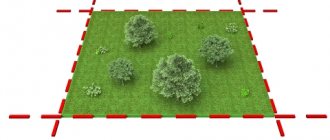
Plot delineation is necessary in situations where one or another property object (housing, garage, plot of land, etc.) needs to be registered with the state cadastral register. This procedure involves identifying individual administrative-territorial objects on the ground, allocating the area of land plots with special boundary signs and coordinates. The land surveying procedure can only be carried out with those land plots that are registered in possession in accordance with the law. These works are not carried out on leased lands.
Land surveying must be carried out for types of land that:
- Transferred from state reserves for permanent use.
- Intended for distribution for one reason or another.
- They require division, consolidation or allocation of shares.
If you want to delve into all the nuances of demarcation, it will be useful to familiarize yourself with the relevant legislative framework:
- Land Code.
- Federal Law No. 221-FZ “On the State Real Estate Cadastre” (its provisions determine the procedure itself).
- New Law of June 23, 2014 No. 171-FZ “On Amendments to the Land Code of the Russian Federation” (this stipulates the legalization of garden plots under the provisions of the dacha amnesty for the period until the end of December 2020)
We remind you that citizens of the Russian Federation are given the right not to carry out survey work on plots of land intended for sale, acquisition or inheritance until January 1, 2021 (Clause 1, Article 19 of the Federal Law “On State Registration of Real Estate” dated July 13, 2015 N 218 -FZ). In the future, the procedure will need to be performed without fail.
Removing the boundaries of a land plot in nature in Moscow and the Moscow region
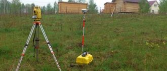
Determining the boundaries of a land plot is a popular type of topographic and geodetic measures, which involve identifying and fixing points with elevation and plan coordinates on the ground. The result of geodetic surveys is the receipt of reliable information, the establishment of elements for marking boundaries and the drawing up of an act that must be registered in the real estate cadastre.
Our company carries out comprehensive work to determine the location of the dividing lines of territories. Experienced surveying engineers are ready to go to any site located in Moscow and the Moscow region and carry out the necessary measurements using high-precision GPS equipment.
Define boundaries
Step-by-step instructions for surveying
Step 1 - preparation of all necessary documentation
When initially allocating a plot of land to carry out demarcation, it is necessary to have at your disposal a diagram of this plot on the cadastral plan, as well as a state resolution on the allocation of this land. Land owners will only need a corresponding certificate from the Unified State Register of Real Estate.
Documents are sent by Rosreestr, as a rule, within three days. You can get an extract much faster using the Rosreestr API. The cost of this service will cost the same 250 rubles, you will receive official information with a digital signature.
Step 2 - finding a professional cadastral engineer
Your goal is to find a qualified cadastral engineer, discuss with him all the details of the work, the price of the service and the method of payment. Next, you need to conclude an appropriate agreement. Remember that work should only be carried out by professionals with experience in this field.
Step 3 - receiving a package of ready-made documents and signing a certificate of completion of work
A cadastral engineer deals with a full range of land surveying works. As soon as the work is completed, the specialist will give you a package of ready-made documents (cadastral passport, technical, boundary plan). To register a plot of land for cadastral registration, you will need a land surveying plan. And in the case of the construction of a certain construction project on this site, a technical plan will be required. Also, all case materials can be provided on electronic media and, if necessary, in paper form. After you personally check all the documentation, you must sign a certificate of completion of work (two copies). You are given one original document.
Step 4 - checking the results of the completed survey
The entire procedure, from the moment the agreement is concluded until the receipt of the completed papers, takes a maximum of 14 days. In a few more days, information about the new land plot and its boundaries should appear on the cadastral map of the Register in public access. You can personally check the results of site surveying using the link. You only need to indicate its cadastral number. This step is the completion of the entire demarcation procedure.
Features of agricultural land surveying
A land share can be formed in 2 ways:
- Based on the decision of the general meeting of all participants in shared ownership. In this case, a land surveying project must be prepared. If there is a project, then there is no need for additional approval of each formed area.
- If there is no solution, the owner can contact the cadastral engineer privately. In this case, it is necessary to coordinate the boundaries with all adjacent land users.
Formation of a land plot by decision of the general meeting
To allocate a share, it is necessary to initiate a meeting of all shareholders. This can be done either by one of the participants or by a representative of the municipality or local government. Notice of the meeting is usually posted either in print or on the Internet no later than 40 days before the date of the meeting.
At the meeting, questions about the need to develop a land surveying project and determine the size of each share are discussed. At the same meeting, a cadastral organization is also selected, which will prepare a boundary plan and a list of other documentation that will be drawn up.
Formation of a land plot privately
If no meeting was held, then any owner can carry out land surveying by independently contacting a cadastral engineer. 30 days before the work, the cadastral engineer places an advertisement in a local newspaper or sends a postal notice to interested parties.
The result of land surveying of agricultural lands is a boundary plan and an agreement that must be signed by neighbors.
How is land surveying day going?
On the appointed day for the work, a specialist from the organization that will carry out the survey will contact you in advance and agree on the exact time of the meeting. Additionally, you need to inform your neighbors. The scope of work will include the following:
- Performing general measurements of an object.
- Determination of coordinates of demarcation signs.
- Designation of the boundaries of the object, coordination of boundaries with the owners of adjacent lands with documentary evidence of their consent.
If all these stages pass without difficulties, then we can consider that the cadastral survey is completed. All work can be completed without your personal participation. However, if you wish to attend, you will have to allocate several hours of personal time on the day the work is performed.
Act of borders with a photo report in Moscow and the Moscow region
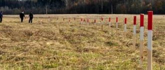
We carry out all types of topographic surveys in Moscow and the Moscow region. Our surveying engineers are ready to mark and securely secure the turning points of the landfill, accurately determine its configuration, area and dimensions, and install boundary markers in accordance with the standards.
Each element of the boundary designation is numbered and assigned.
To document the location of signs, our experts can provide a report with a photo report. It consists of an explanatory note with detailed information about the object, the contractor and the customer, a diagram of the location of significant turning points, and photographs of numbered boundary signs.
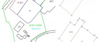
What does a boundary plan look like?
Confirmation of the completion of the entire procedure is the boundary plan (or file). The plan includes text and graphic parts. The boundary plan should display all measurements taken, data for the cadastre and acts for resolving controversial issues. The document includes the following:
- Initial information of the object.
- Information on all measurements taken on the site.
- Information on the formation or change of a land plot.
- A diagram showing the location of the object.
- Drawing of the site (its parts).
- Geodetic diagram of buildings.
- Additional documents (copy of media notice, copy of no-objection certificate).
When is it necessary to set out boundaries?
An accurate procedure for determining boundaries is necessary when solving the following problems:
✔ construction of a new facility - determining the coordinates of the location of turning points makes it possible to mark the boundary of the site, clearly see the shape and size of the territory, and prepare for construction;
✔ purchasing a land plot - makes it possible to avoid disputes, properly formalize and carry out the purchase and sale procedure;
✔ division of the land plot between all owners - defining the boundaries of each part of the object helps to establish precise boundaries and avoid disputes and mistakes during division;
✔ landscape design - precise determination of the parameters, shape and size of the landscaped area allows you to correctly plan the location of elements, green spaces and communication networks, and achieve an aesthetic final result.
Who carries out the survey and how to choose a contractor?
Responsibilities for carrying out demarcation work are assigned to the cadastral engineer. The work of a specialist in this profile is regulated by the provisions of the Federal Law “On the State Real Estate Cadastre” No. 221-FZ dated June 24, 2021. Mandatory conditions are: the presence of a valid qualification certificate, a contract of compulsory civil liability insurance, and the specialist must also be a member of a specialized self-regulatory organization.
Finding a suitable specialist will become much easier if you use a special service on the Rosreestr website (section “Register of Cadastral Engineers”). Here you can find out detailed information on the activities of a specific cadastral engineer by indicating his last name. You will find out whether the specialist really has a valid certificate, what self-regulatory organization he is a member of, how effective his activities are (how many refusals there were according to the documents he prepared), etc. This information will help you make the right choice.
Helpful advice: before entering into an agreement with a company or cadastral engineer, you should read reviews about their work. If you cannot find real reviews on the Internet, then you can rely, for example, on reviews on Google maps. Specialists with higher ratings deserve more attention. It is also important that the land surveying agreement spells out the rights and obligations of each party, as well as the rules for canceling the agreement itself.
How much does land surveying cost?
Specialists in the field of delimitation are not subordinate, so the state is not involved in developing prices for these services. Municipal organizations have a certain price calculation scheme, however, their work is not efficient. Private firms have the right to set their own prices for their services, based on various factors and current market conditions.
The formation of the cost of land surveying work is influenced by the following: the territorial location of the object, the area and category of the land plot, the complexity of its shape. Very often, companies that have just entered the market offer lower prices for their services. At the same time, the quality of their services does not differ from competitors who have been working in this field for a long time. One way or another, you need to take the choice of a performer seriously. After all, the cost of services in this area can vary significantly: for example, the price of work in the Moscow region can range from 10 thousand to 30 thousand rubles, in other regions the price starts from 5 thousand.
Some organizations provide the opportunity to pay for the service in installments: half is paid when the contract is signed, and the second half of the amount is paid after completion of the work. Do not forget to keep a document confirming the fact of payment (cheque, receipt).
How to survey a plot of land for free?
Russian citizens can demarcate a plot of land for free, provided that the entire range of work initiated by state representatives is completed. All information about completed and planned demarcation is presented on the official website of the municipal authorities. The land owner has the opportunity to seek help in carrying out free work from one of the organizations listed on the website. To do this, you need to provide an application indicating the address, cadastral number and personal information of the owner.
The following reasons can be identified for receiving a free demarcation service:
- There is no information about the land plot in the Unified State Register of Real Estate, but the owner registered the right of ownership before 1998.
- A cadastral error was made (the fact is confirmed by relevant documents).
- The plot is not listed in the cadastral register, but is noted in Rosreestr.
You can also carry out land surveying for free on the basis of a dacha amnesty. But here it is more appropriate to say that this is not free work, but rather not obligatory. Demarcation does not need to be carried out without fail since 2007, so it is possible to register ownership without this procedure. However, such rules will only be in effect until the beginning of 2021.
It is worth noting that in the Land Code of the Russian Federation in Art. 39.9 some adjustments appeared (from 06/01/2015). Thus, free demarcation is possible when transferring a new land plot to Russian citizens who have three or more children, as well as to those who need housing (in this case, citizens must be on special registration).
Registration in Rosreestr
The allocation of a land share to an interested party is, in essence, a property transaction, as a result of which a new owner appears for a certain plot. For this reason, the latter must register his rights to the territory. For these purposes, you must contact the Rosreestr authority at the location of the share.
The text of the statement states the following:
- Name of the registration authority.
- Information about the person concerned - name, where he lives, passport details, date of birth.
- Location, boundaries and total area of land.
- Application for registration of legal capacity in relation to the territory.
- List of documents that are sent along with the application.
- Date of application and personal signature of the person.
The following must be attached to the application:
- Passport.
- Power of attorney of the legal representative who participates in the procedure.
- Cadastral passport.
- A document confirming payment of the mandatory fee for recording the legal capacity of the interested person.
The interested party may send copies of the information. They must be certified by the organization that issued them. At the same time, you must have the originals on hand, which may be required for verification.
You can submit the necessary data along with your application in several ways:
- By contacting the Rosreestr authorities in person.
- With the help of a trusted person.
- Through the multifunctional center.
- via postal or Internet communication.
The method of referral is determined by the person concerned. The final stage will be the issuance of a certificate of legal capacity of the owner.
How to notify neighbors about land surveying?
It is necessary to inform neighbors about the upcoming work in advance, informing them of the exact time of arrival of the specialist. Neighbors will need to confirm that they agree with the land surveying, so they will need a passport of a Russian citizen. To register plots that are part of a dacha or garden partnership, the consent of the Chairman of the Board is required. Basically, the issue of notifying neighbors is dealt with by the work performers, which is stipulated when concluding the agreement. This can be done by telephone or by registered letter. But neighbors always have the right to refuse to sign a certificate of completion of work.
What to do if your neighbor doesn't agree?
During the work, various controversial situations may arise with neighbors, which is not at all uncommon. It is better to prepare in advance for possible compromises. For example, to successfully and quickly complete demarcation, you can make small concessions if a conflict arises with a neighbor. Indeed, in the event of a trial, you will spend a lot of personal time and incur additional financial expenses. Under any circumstances, all controversial issues must be recorded in documentary form. If, however, the case comes to court, then the entire history of the site will have to be presented.
Other problems when surveying land plots
The most common problems with demarcation include an increase in the actual boundaries of the site. The provisions of the Federal Law “On Amendments to Certain Legislative Acts of the Russian Federation on the Issue of Registration in a Simplified Procedure of Citizens’ Rights to Certain Real Estate Objects” No. 93 dated June 30, 2006 states that the area of your plot of land can be increased only within the minimum possible size of the plot, indicated in the relevant regulatory documents of local authorities or constituent entities of the Russian Federation and provided that these authorities have provided their consent.
Simply put, if the minimum possible size of a plot is, for example, six acres, then you can expand your land plot only within the same area. But this is rather a theoretical possibility, since in reality the authorities are in no hurry to give their consent to expansion.
List of required documents
Before starting geodetic work, the specialist should be provided with a certain package of documentation. The cadastral engineer studies the papers and creates a plan for work on the site.
Documents required for land surveying:
- certificate of ownership of the dacha;
- cadastral passport of the dacha territory;
- technical document for all buildings located on this site;
- resolution of the local administration on the provision of land;
- cadastral plan of the territory indicating all plots in the partnership.
It is also required to collect notifications from all owners of adjacent territories about their consent to the establishment of boundaries.
If the preparation of all documents will be carried out not by the owner himself, but by his representative, then a notarized power of attorney is required for this. Such a document will cost not much more than 1000 rubles.
All the details about carrying out land surveying can be found here, and about why the procedure is needed and whether the owner must do it, read this article.
How to challenge the land surveying?
The first stage is sending a corresponding request to the authorities describing your problem. If you received a written refusal from the administration to resolve the issue, then in the future this document can be used for pre-trial proceedings regarding violation of your right to challenge. The next step is to write a complaint to the prosecutor's office and wait for the department's response. If you receive a refusal here, you will have to move on to a full-fledged trial.
In order for you not to lose hope for the success of a judicial challenge to your case, you can familiarize yourself with useful materials: Resolution of the Plenum of the Supreme Arbitration Court of the Russian Federation and the Supreme Arbitration Court of the Russian Federation No. 10/22, Resolution of the Plenum of the Supreme Arbitration Court of the Russian Federation No. 54.
Making a decision about allocation
The decision to allocate a land share is made by the owner of the territory. In practice, this could be any agricultural organization that owns land. Also, the decision can be made by other owners if the land is common, and the person intends to allocate a separate plot for himself. To do this, a meeting is held at which the issue is discussed. The final decision is made by a majority vote. The results are documented in a protocol. Such a document will be the starting point for the further implementation of the procedure.