What instruments are used in geodesy? What do SNiPs regulate when carrying out geodetic work in construction? What services include topographic-geodetic and surveying works?
Hello, dear readers of the HeatherBober online publishing house! I bring to your attention a new topic - geodetic work.
It will be difficult to understand it without special education, and therefore I, Viktor Golikov, a surveyor and part-time author of articles on the portal, will conduct field research for you! Yes, here you need to study and assimilate such seemingly unnecessary knowledge. But if you want to build a house, you can’t do without them!
This topic is for real men who stand firmly on the ground. Only by thoroughly understanding what geodesy is will you build a reliable, beautiful and comfortable house. But building housing differently, at random, is a bad idea!
We get rid of conventions and begin to compare our plans with the platform where the construction will take place. Begin!
The procedure for carrying out geodetic work - the main ones
During any construction, geodetic research is in demand. Whether it is one house or an entire block, or even a city, a street, an industrial complex - everywhere the initial intervention of specialists is necessary. When creating projects, engineers rely on the terrain, dependence on the surrounding infrastructure and the structure of the soil. The entire complex of geodetic work is designed to position construction objects in accordance with an approved plan. That is why surveyors work on constructed structures until they are put into operation.
Equipment
Fulfilling the tasks assigned to surveyors is impossible without special instruments, the list and description of which is determined by GOST 21830-76:
- for measuring angles - theodolites (code, astronomical, etc.);
- to determine line lengths - rangefinders (optical, filament, electromagnetic, etc.);
- for measuring heights - levels, profilers and altimeters.
In addition, combined instruments are used: tacheometers, kipregels, topographic surveyors, as well as other devices.
To measure angles using this device, a specialist must point the viewfinder at a given point in a graduated eyepiece and record the values of the direction and inclination angles (horizontal and vertical). The simplest theodolite has an optical-mechanical design. Today, a number of electronic modifications of these devices have been created, which, using sensors, transmit values to the screen and store them in the device’s memory.
Rangefinder
When measuring length using an optical - passive - rangefinder, determine the height of the triangle through the measured side and the value of the opposite angle. Devices based on an active measurement method have also been developed, operating on the principle of sending a certain signal to an object: ultrasonic or laser (light). Today, there are modernized laser models with color monitors, equipped with Bluetooth modules, continuous operation and volume measurement functions.
Level
The level works as follows: the device is placed on level ground and the telescope is brought to a horizontal position. Looking into it, note the position of two points - the original and the measured. A device called a measuring rod is placed sequentially at the initial point and then at the point being measured. In this case, readings are taken in the first and second cases. The difference in readings is the height value.
In classic levels of optical design, a bubble ampoule is visible in the viewfinder, by looking at which the telescope is brought to the desired position. Electronic levels are equipped with compensators, digital reading devices, and liquid crystal displays. A separate group consists of laser devices that do not have a telescope. Fixation on a point is carried out by directing a laser beam at it.
Total station
A combined device that allows you to simultaneously measure angles, heights and lengths. Modern electronic devices make it possible to carry out measurements in conditions of reduced visibility, as well as in the presence of small obstacles. In addition, there are optical and automatic devices.
Locator
Serves to determine the position and depth of communications: cables, pipes, which are under the influence of electrochemical protection. They are used to survey the area before carrying out work, as well as to search for hidden wiring and check the condition of communications.
Equipment for topographic survey from the air
Topographical surveying from the air has been used for more than a hundred years, but the development of digital technologies, the creation of unmanned aerial vehicles and satellite systems has brought it to a qualitatively new level. It provides the opportunity to obtain not only a topographic plan and orthophotomap, but also a spatial 3D model.
The use of UAVs, digital aerial cameras and laser scanners for aerial photography significantly simplifies and reduces the cost of geodetic work, while simultaneously ensuring high accuracy of measurements. When conducting surveys, reference points are used, which are placed both around and inside a given territory or object according to the scheme.
They are used as a basis for processing information by photo programs, and the accuracy of the shooting result largely depends on their position. As a result, a general image is formed. Based on it, a digital terrain model and otrophotoplan are created.
Accuracy of measurements
In practice, it is impossible to carry out any measuring work absolutely accurately, therefore, for the correct execution of geodetic work, the specified accuracy is assumed in advance, and the methodology for performing the work and the required instruments are selected according to it.
To regulate the requirements for methods and accuracy of the area and coordinates of characteristic points, Order of the Ministry of Economic Development No. 90 dated March 1, 2016 was approved. and an appendix to it.
Modern technical means make it possible to carry out geodetic measurements in difficult weather conditions, poor visibility and other related factors and to develop technical documentation in accordance with specified accuracy requirements.
Geodesy work according to the law and rules
There are a number of regulatory documents that establish requirements for all geodetic work. Let's consider the main ones:
- Federal Law 122-FZ “On State Registration of Rights”.
- SP 47.13330.2012 Engineering surveys for construction. Basic provisions. Updated edition of SNiP 11-02-96.
- SNiP 11-04-2003 “Instructions on the procedure for development, coordination, examination and approval of urban planning documentation.”
- Order of the Ministry of Economic Development of the Russian Federation on approval of types of boundary signs No. 582 dated December 31, 2009; Order of the Ministry of Economic Development of the Russian Federation (Requirements) No. 518 dated 08/17/12.
In order for the results of geodetic surveys of the area to be documented with full legal force, such work should be performed only by professionals from an organization with a license to carry out such activities.
Why do you need site geodesy?
An appropriate set of measures is required for any construction, restoration, or reconstruction work. The first thing that comes to mind when you hear the word “surveyor” is drawing out boundaries in nature or determining them using data from the State Real Estate Register. There are various scenarios in which geodesy will be required.
When surveying land plots
Before purchasing a plot, you need to check it thoroughly. If the agent cannot indicate clear boundaries of the plot, it means that geodetic surveys have not been carried out. This causes a lot of problems. In addition, the citizen will be able to understand the features of the relevant territory from the graphs provided to him.
Connections between geodesy and sciences
Currently, they are so wide that it is impossible to list everything. Undoubtedly, the first science from which geodesy can be said to have originated is geometry. Next, we list all the other general disciplines with which geodesy is in contact:
- mathematics (arithmetic, geometry);
- astronomy;
- geography;
- physics (mechanics, optics);
- geophysics;
- geology;
- photo;
- topographical drawing;
- Informatics;
- geographic information systems;
- cartography;
- computer systems.
In what cases is land surveying necessary?
There is a whole list of cases when land surveying becomes necessary. We list the main ones:
— it is necessary to register ownership of the land plot;
— the owner of the land is going to divide the land plot for sale or transfer it by inheritance;
— disagreements have arisen between neighbors regarding the boundaries of their plots (Russian courts annually consider thousands of cases on the so-called neighbor wars);
— it is planned to divide the land plot into two or more independent plots;
— it is planned to combine two or more land plots into one.
The principle of topographic and geodetic work
At the very beginning, together with the customer, they draw up technical specifications and sign an agreement on the implementation of engineering and geodetic surveys. Next, archival materials and current topographic plans of previous years are studied to determine the direction of research. According to the information collected, they draw up a program of topographic and geodetic work at the construction site of buildings and structures, and then begin to implement it.
At the field stage, reconnaissance of the selected part of the territory and work with reference and plan-altitude geodetic networks is carried out. After this, they begin topographic surveying of the area using special geodetic equipment. If necessary, some studies can be repeated.
At the desk stage, specialists work with topographic plans in digital form, which are compiled or updated based on the collected materials during the field stage of topographic and geodetic work. It is important to coordinate the application of not only objects, but also engineering communications (underground and above-ground) in different operating organizations.
Geodesy in road construction
Every day, hundreds and thousands of cars, both cars and large trucks, travel along the highways connecting major cities. Which carry out transportation, transport cargo to industrial facilities, etc. In order for a new highway to last for ten years without major repairs and to easily withstand high loads during its construction, it is necessary to take into account all factors, especially the local soil.
Geodesy during road construction makes it possible to design a highway in such a way that builders can make it as resistant as possible to the expected high loads and various weather factors.
The specialist drawing up the design documents must know detailed information about the area, geological and hydrological conditions where the future highway will be laid. Also, this data allows you to determine the nearest place of extraction of important construction materials for the route: sand, gravel and others.
And what is important, a detailed map allows you to choose the most convenient place to build the route.
ORDER FROM US
Order a consultation
or call us yourself +7 (473) 228-93-69
How to clarify the boundaries of the site?
Rosreestr spoke about the sale of real estate in which children live
Land surveying is carried out by cadastral engineers. They are the ones who carry out all the necessary measurements and calculations. By law, every cadastral engineer is required to be a member of a specialized self-regulatory organization (SRO). SROs monitor the activities of their members and consider complaints from applicants if cadastral work was carried out with violations.
You can obtain information about a specific cadastral engineer on the Rosreestr website in the “State Register of Cadastral Engineers” section. It contains information about his special education, qualification certificate, and confirmation of his membership in the SRO. In addition, using the electronic register of cadastral engineers, you can find out about the results of a specialist’s professional activities.
A cadastral engineer visits the site and takes the necessary measurements. If there is a fence, then measurements are taken along it. If there is no fence, it is better to mark the corners of the area with pegs in advance. After reviewing the measurement results, the boundaries of the site must be agreed upon with the owners of adjacent plots.
After this work, the cadastral engineer draws up a boundary plan.
Why is a cadastral passport needed?
We recommend that you read:
Setting out points to plot boundaries
If a cadastral passport has already been issued for an object and a cadastral number has been assigned to it, anyone can obtain information on it. It is freely available. To receive it, you need to write an application indicating the number or find the object on the official website of Rosreestr.
If the property is only being registered in the cadastral register, then this can only be done after a land survey, which is ordered personally by the owner of the property.
A decree for cadastral registration is necessary both for the owner himself and for the state as a whole. First of all, we are talking about paying property taxes. This allows you to streamline taxes and fees. But to perform such actions you need to have accurate information about objects. In this regard, the state obliged citizens to draw up cadastral documents. Without them, it is impossible to complete a single transaction.
Having assigned a number and received a passport, the owner acquires full rights, and the state acquires complete information necessary for calculating taxes.
A passport issued by the cadastral chamber is required in the following cases:
- when making transactions with real estate, this includes purchase and sale, donation, will;
- when remodeling an apartment, changing the boundaries of a site;
- during legal proceedings;
- according to bank requirements.
A cadastral passport will always be required in cases where it is necessary to confirm that an object is registered in the cadastre.
A cadastral passport is obtained for the following types of objects:
- Plots of land.
- Houses, buildings, unfinished buildings.
- Premises.
The cadastral passport does not have an expiration date; it will be valid until the data entered in the cadastre is changed. A new paper is required when the premises have been redeveloped or the boundaries of a plot of land have been changed.
A cadastral document received before January 1, 2013 has its own validity period. For residential premises, the document was valid for one year, after which it was necessary to apply again to the cadastral chamber for an extension, for all other structures - 5 years. But after the transfer of powers from the BTI to Rosreestr, such actions are no longer carried out.
Where and on what principle does it work?
For a long time in Russia there was a state monopoly on geodetic work, and all the necessary research was carried out by specialists from exclusively state-owned organizations and enterprises. Almost all the data received was classified by the military.
What about your work routine?
The work schedule of a surveyor is very different from the usual work routine. Of course, many people work 5 working days and rest for 2 days. They work for a salary and possible bonuses for overtime, etc. Most often this happens at state-owned enterprises, for example at Mosgorgeotrest and the like. There is a shift method. That is, the surveyor spends time on business trips from 2 to 6 weeks. And he works there every day. Usually they work on a rotational basis in remote parts of our homeland when laying gas, oil pipes, etc. There is an option to work according to actual workload. That is, this is work on a contract basis. If there is work, it works, if there is no work, you can rest. In general, depending on the nature of the surveyor’s workload, the choice is very large.
How to draw up a land survey plan for a multi-circuit area
Multi-circuit plots have a complex configuration: they consist of several circuits or have “holes” - for example, a land plot of two parts that are separated by a road, or a plot on which a power transmission tower is installed.
For such areas, a single boundary plan is drawn up, which describes all the individual parts of the site, and the multi-circuit area itself receives a single cadastral number.
When surveying multi-circuit areas, difficulties may arise. For example, the site may be long, which will complicate geodetic measurements. Or, due to the fragmentation of the site, there may be common boundaries, for example, with six neighbors - such a number of participants will complicate coordination. All this will affect the cost of surveying and the timing of work.
Stages of geodetic survey
How is land surveying done? The work of surveyors is divided into stages, following one after another:
- Topographic survey. A professional must go to the site that will be examined, take soil samples there, find out the presence of groundwater and make all the necessary measurements.
- Geodetic works. They are carried out on the area intended for future construction. During the work, slopes and elevation changes are determined, since utility networks may pass there, both underground and on the surface, such as pipelines, various cables, etc. And also as a result of geodetic work, proposals and recommendations are made regarding the location on the site of the future building.
- Coordination of discovered underground and above-ground utility networks with the relevant utilities.
- Engineering and geological work. The soil on the plot of land, as well as in the laboratory, is examined very carefully. As a result of these activities, a written conclusion is drawn up regarding the bearing capacity of the soil in a given area.
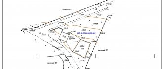
- Drawing up a boundary plan for geodesy is necessary to determine the areas of land plots and their boundaries. For accurate measurements, boundary markers are marked throughout the entire territory.
- Comparison of the design of the future facility with the data obtained as a result of the study. This is done to check compliance. Sometimes it becomes necessary to make corrections to the plan, get advice on the construction of the foundation and the exact location of the building.
Where to go in Yaroslavl: the most popular places Go
Geodetic work on a plot of land usually requires a team consisting of several different specialists: a cartographic engineer, a topography specialist and a surveyor.
Geodetic survey of a land plot is the basis for the construction of a house and other objects, as well as cadastral work. Satellite photography has the highest measurement accuracy.
The timing of geodetic surveys depends on the size of the site, season, weather and other factors.
List of studies on land geodesy:
- study of the landscape of the territory;
- identifying the exact boundaries of the land plot, which is obtained as a result of land surveying;
- identifying turning points;
- search for all available communications;
- photography of construction sites located on the site.
How much does land surveying cost?
Cadastral work is carried out by a cadastral engineer on the basis of a contract for cadastral work. The cost of work is determined by the parties to the contract based on the estimate.
The price of land surveying depends on many factors. It can vary both due to the prices of the organization itself that carries out the work, and from the specific site - its features, configuration, location, size and type of work (formation of a new site, division, redistribution of land).
On average, the price of the service for citizens is up to 20–30 thousand rubles. For example, the cost of preparing a boundary plan to clarify the boundaries of a land plot of up to 8 acres will vary from 12 thousand rubles. up to 16 thousand rubles. Clarifying the boundaries of a plot of 10 acres in the region will cost up to 10 thousand rubles. If it is necessary to create a site for an apartment building, then the amount charged is approximately 70 thousand rubles, a representative of the Agency for Legal Development gave examples.
In addition, the legislation provides for the option of free land surveying. We are talking about cases when, by order of the authorized body, a complex of cadastral works is carried out on the territory of one or several cadastral blocks.
Legal basis of geodesy
The activities of surveyors, from the point of view of their compliance with legal acts, are regulated by the Constitution of the Russian Federation, the law on geodesy and cartography and some other by-laws. Thanks to these laws, the state establishes how geodetic surveys of the area are organized, what rules should be followed during their implementation and what technical requirements must be adhered to.
Most of the legal norms are approved by the state body in the field of cartography and geodesy, operating at the federal level. Subjects carrying out geodetic activities are required to comply with these standards when performing measurement work . The state supervises specialists and organizations involved in the provision of geodetic services and applies negative sanctions to violators in the form of punishments enshrined in the relevant articles and provisions of the Criminal Code and the Code of Administrative Offenses.
Geodesy as an integral part of history
Geodesy originated thousands of years ago, and we have come down to a lot of archaeological evidence that maps and plans of a geographical and economic nature were created in many developed countries of that period.
Aristotle was able to give a more precise definition of it in the 4th century BC. in his famous work Metaphysics, and Plato’s famous words “The gods love geometry” undoubtedly emphasize the importance of geometry and geodesy in the life of ancient society.
Pythagoras, who suggested the spherical shape of the Earth, and Copernicus, who scientifically confirmed his theory, also did a lot for the development of this science. The great geographical discoveries, the industrial revolution and subsequent technological progress finally shaped its current appearance.
However, it is difficult to say where exactly it originates. Most likely, from the very moment when a person realized that the space and time in which he exists must be oriented. The need to divide the land could also arise with the development of agricultural activity.
Registration and registration with government agencies
According to the requirements for geodetic work, the research results must be documented in the form of conclusions . They must be registered with the Architectural Bureau at the location of the shooting, before they are approved.
Scheme of work of the geodetic organization:
A company providing surveying and research services must have the appropriate license to perform such work. Only in this case can their conclusions undergo all approval procedures and be registered with the relevant authorities.
Interaction between the customer and the company is carried out on the basis of a written contract for the provision of services .
On average, the following stages :
- Conclusion of an agreement
- Departure of a team of surveyors to carry out work on the ground
- Performing surveys using special equipment
- Drawing a topographic map of the site
- Presentation of the results obtained in writing
- Payment and transfer of results to the customer
- Work on coordinating geodetic surveys
The sequence and stages can be adjusted depending on the specific conditions, goals and objectives of the customer, so the diagram is approximate.
Where to order high-quality geodetic services - review of the TOP 3 geodetic companies
With the development of geodesy and the increasing demand for land surveys, the growth of companies providing surveying services is expanding.
We have compiled a review of the 3 most reliable geodetic organizations in the Russian Federation.
1) Earth-Pro
The company provides services for a variety of geodetic works. The organization’s employees are ready to carry out the necessary research as soon as possible and draw up a package of documents characterizing your land plot.
The company's surveyors are ready to take on the most non-standard tasks and provide a guarantee for all work done.
If you are ready to become a client of the company, then you will be given several cooperation options to choose from. After comparing the conditions and prices, you will choose a program that attracts you; they will tell you what other documents are needed to formalize construction, and correct technical errors in existing land plans.
2) Nakor-K
The company operates throughout Russia. Founded in 2000, the company takes a responsible and high-quality approach to performing various types of tasks within the profile of its industry.
Types of activities practiced:
- engineering and geodetic surveys;
- geodetic support of construction;
- control over the deformation of structures during the construction of structures;
- other research.
Nakor-K is an established team of professionals that offers a wide range of services, comprehensive studies and unique solutions in the field of geodesy.
3) Geodetic
A young, ambitious company focuses its activities on performing a range of geodetic surveys in construction and industry. The company's experts are graduates of leading Russian higher educational institutions. Highly qualified specialists work both throughout Russia and abroad.
The company's competitive advantages lie in the use of modern technologies, high-precision instruments and the development of new data processing methods. The results of the work are provided to clients both in classic paper form and in electronic form.
Features of executive shooting
After topography comes a new stage that requires the presence of a surveyor. We are talking about earthworks. Here, the specialist is required to carry out the so-called outreach of the object, when the axes of the house are divided on the site depending on its connection to the site.
At this stage, the main tasks of geodesy in building a house are to determine the depth of pouring the foundation slab and creating the zero level of the house. The next task of the surveyor is to control such nuances as the arrangement of floors, as well as vertically and horizontally oriented load-bearing elements of the building. At the same time, their location is assessed in accordance with acceptable standards.
What problems does geodesy solve - 4 main tasks
With the help of geodetic science, humanity is trying to study and use its home planet. Geodesy as a practical science helps people navigate their habitat, improve and modify the surrounding area.
But the main application of geodesy is the construction of buildings and other structures.
Task 1. Selecting a suitable location for the object
It is thanks to geodesy that the location of the construction site is chosen. Factors of the structure of the earth's thickness are taken into account. The area is being explored and geological surveys are being carried out.
A plan diagram of the occurrence of rocks is drawn up, based on which the composition of the foundation to be laid is determined. Or the surveyors' recommendations will be made in favor of moving the construction site, or even completely canceling the plan.
Main criteria for placing construction sites:
- composition and characteristics of rock layers;
- terrain;
- surrounding areas.
Task 2. Competently linking the building under construction to existing ones
Since construction has become a human passion for quite a long time, and gigantic areas of the Earth have been built up, it would seem impossible to imagine a disorderly accumulation of houses in places where people live.
How possible! That is why megacities are constantly being built, rebuilt and completed. They grow up and down and spread across the surface of the planet like mold on wood. And if it weren’t for geodetic design, I’m afraid the human anthill would have collapsed like a house of cards.
And from the point of view of comfort, it is more convenient for people to locate their structures depending on existing buildings.
Example
At first, Academician Kurchatov did not begin to lay paths around the institute under his jurisdiction. Having waited for the moment when the employees themselves would trample the paths they needed, he ordered them to be asphalted.
Task 3. Representation of areas on topographic maps
Using topography, you will receive a detailed plan of the building area. It will display all objects located on the ground, their connections and utilities.
The diagram will also display the terrain.
The topographic map is compiled in three stages:
- Field work (on-site measurements).
- Office work (bringing calculations together).
- Drawing up a plan (drawing a map in accordance with the data received).
Using topography, it is easy to restore the boundaries of a site on the ground.
Task 4. Study of large-scale displacements of the earth's crust
This is the task of higher geodesy. It is thanks to such work that earthquake-resistant areas and areas susceptible to surface distortion are determined. The dependence of shifts of the earth's crust platforms on satellites, planets and other cosmic bodies of the solar system is revealed.
The ebb and flow of tides, active uplifts and stable depressions of areas of the Earth's surface are all important basic principles of global geodesy. These factors influence the planet's climate, and they are studied through environmental research.
How to coordinate the boundaries of the site with the neighbors?
Rosreestr will verify the borders of the Russian Federation on geographical maps
The cadastral engineer will also help in coordinating new boundaries with the owners of adjacent plots: he must send them notifications by postal or e-mail; individual approval is also allowed.
If they cannot be found, the cadastral engineer publishes a notice in the local press. The addressee will be considered notified even if he does not read this announcement.
Rights holders of adjacent plots must confirm their consent by signing an agreement document. If they do not agree, they can forward their objections to the cadastral engineer. Objections must be recorded in the act of approving the location of the boundaries of the land plot, and also attached to the boundary plan.
Next, the documents must be submitted to Rosreestr. If there are justified objections, registration and registration activities will be suspended, and neighbors will have to resolve disagreements in court.
What do surveyors do during a geodetic survey?
Main responsibilities
According to legislative norms, the participation of surveyors in the future construction of an object is not limited to the direct implementation of geodetic surveys. They are required to do a whole range of actions that precede the shooting, and are also carried out after it:
- Studying a construction project . At this stage, specialists read design documents, get acquainted with the features of the future building, and develop a plan for the future geodesy of the facility. To put this briefly, surveyors conduct a preliminary examination of the object of their subsequent work.
- At the second stage, the geodetic survey , during which the landscape and other features of the land plot are examined, which can have a significant impact on the construction process and lead to changes in plans. Specialists should also check the land plot for the presence of abandoned or unknown communications, for example, heating or water pipes, and check whether there are any unused structures on the site. After the survey, the construction plans are adjusted, and a control final geodetic survey is carried out, with the goal of clarifying and verifying the results obtained, on the basis of which a plan of the land plot will be developed with all the necessary coordinates necessary for the successful completion of the construction of the facility.
Additional Responsibilities
Other duties performed by surveyors include their participation in the examination of future construction projects, when they can, thanks to their experience working in the “field,” point out errors in design, for example, errors of an architect who does not take into account the nature of the soil of the area, which is a very important parameter in surveying, and designs a building from materials that may have their performance degraded due to construction on unsuitable soil. Specialist surveyors can also accompany the construction and installation process, namely: tell workers where communications need to be laid and where it is necessary to strengthen the land slopes.
What is topographic survey on a scale of 1:500, how to carry it out and examples of ready-made topographic maps, you can find out here
Mine Surveyor
Mine surveying is a branch of mining science and is closely related not only to mathematics and physics, but also to geology, hydrology and geomorphology. It is also commonly called “underground geodesy”, since it is accompanied by similar procedures, but not on the ground, but under it.
This discipline is associated with mining and geodetic scientific disciplines. Based on the measurements taken and processing of their results, the structure of the mineral deposit in the bowels of the Earth, the presence of useful and harmful components in them, as well as the properties of the rock are determined.
The surveyor exercises full control over the construction processes of mines, subways and other underground structures in compliance with their design parameters. Supervision of their deformation is also an integral part of his work.