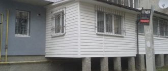
The need to create a geodetic alignment base arises during the construction of a real estate property .
This basis is carried out by a geodetic organization and represents a network of fixed points.
The designated points make it possible to determine with sufficiently high accuracy the position of construction objects relative to their height.
Moreover, this possibility arises in relation not only to individually located buildings and structures - we can talk about entire complexes.
In any case, no matter how many structures we are talking about, they will all be tied to certain points of the geodetic network of the state. appointments.
When displaying the necessary objects, it is imperative to take into account the placement of existing structures and networks , as well as those that exist only in the project.
The contractor of the alignment base must also take into account ensuring the stability of existing signs , through the existence and placement of which the installation of fastening points and various processes are carried out, which are important for the operation of the structure, taking into account construction and sanitary standards.
Purpose of GRO
The main purpose of this type of work is to solve problems :
- Realization of planned projects during the construction of objects or laid utility networks;
- Determining the boundaries of a plot of land that is necessary for construction on it;
- To determine the optimal parameters and other characteristics of objects that will be located on the site of interest to developers;
- To ensure optimal installation of equipment.
Separately, the tasks to be solved are highlighted if it is necessary to use plots of land for agriculture.
In such a situation, the main goals will be to correctly determine the boundaries of a land plot, indicating the boundaries of land use, resolve disputes regarding boundaries that may occur between owners of adjacent plots, as well as clarify the passage of boundaries when determining inaccuracies or errors that arose during the process of surveying a territory or a separate piece of land.
SNIP
The construction of a geodetic alignment base is regulated by the reflected standards in SNiP 3.01.03-84 “Geodetic work in construction”.
This document contains general provisions regarding the implementation of work, norms for geodetic alignment, rules for carrying out alignment work, as well as control of the accuracy of execution and methods for checking the laid out bases.
SNiP determines the need to comply with existing standards regarding the conduct of various types of geodetic work. In addition, other standards in accordance with which utilities or buildings will be erected must be taken into account.
Leveling grids and staking out
The leveling network is the high-altitude basis of geodetic measurements and scales. It creates a unified system of heights throughout the country.
Leveling nets are used to place marks in nature and secure them with benchmarks. In this case, the signs are placed so that they transmit to the object any height mark with 2 or more signs.
To lay reference marks, objects that have existed for at least 2 years are used.
It’s good when you manage to combine points of the high-rise and planned networks.
Ground benchmarks are exposed to groundwater. Therefore, areas with bedrock exposure and low groundwater levels are selected. This helps to avoid situations where ground benchmarks move under the influence of groundwater.
High-altitude alignment networks are built using closed leveling passages and a system of polygons.
What does the Laboratory of Expertise from GRO offer?
The following services can be ordered at the Expertise Laboratory
- Removal of geodetic alignment base
- Calculation of excavation volumes
- Topographic survey.
It is optimal to design a construction grid on the topographic plan of the construction site with existing technical designs for utilities.
Surveyors solve problems that increase exponentially from year to year. New technologies and high-precision equipment make it possible to ensure accurate results and increase the efficiency of the process.
GRO breakdown is carried out in accordance with current standards. The services and work of the Expertise Laboratory meet the requirements of SNiP.
Points and axes of building structures are fixed on the ground, which are marked with stakes, pins, paint and dowels.
Measurements are carried out on the basis of the existing gas distribution facility.
Construction
The description of the basis consists of several stages, each of which must be carried out taking into account existing standards.
So, this process consists of the following stages :
- Drawing up a plan for building the foundation;
- Removal of alignment axes determined by the contractor;
- Formation of an external distribution network;
- Removal of the sign laying area.
Planning
Creating a plan is the initial stage of construction and is carried out taking into account the stages of design and the order in which the construction of objects will be carried out.
The design of the scheme is carried out taking into account the scale of the main construction project of the site that will be used for the construction or laying of the network.
In parallel with this, it should be taken into account:
- Placement of buildings already existing on the site and those planned for construction in accordance with approved construction projects;
- Ensuring the safety of those signs that are fixing points;
- Temperature and other processes that may have an adverse effect on the object being built or the communication being laid, due to which the operation process may be difficult and, subsequently, impossible due to the loss of the necessary characteristics of the structure;
- The need to use a breakdown base already in the process of operating the building, as well as carrying out expansion work, reconstruction with changes in certain parameters, or restructuring.
Stakeout
To achieve one of the main goals - creating a alignment axis, the axes that will be characterized as alignment are carried out.
In addition, such work is carried out to achieve the task of transferring the alignment axes to nature.
When carrying out the carrying out of the central layout of the structure, they are formed in the following form :
- Red lines or other designations adopted in construction;
- Any types of geodetic or construction grid. In this case, the scale can be 50, 100 or 200 meters.
External breakdown
The formation of an external alignment network is carried out by displaying a geodetic grid. All its existing points are fixed relative to the offset of the axis, and the angles that are formed through the intersection of the axes that act as the main ones are separately identified.
Also, when designating the external alignment axis, take into account the following :
- The need to form an external network;
- The need for the base of the height grid is at least 2 benchmarks;
- Depending on the parameters of the buildings being erected or the communications being laid, ensuring the requirements for combining points of the leveling and planned alignment network.
A separate point will be the formation of a high-altitude geodetic alignment base - this process is carried out through agreement with the terms of regulatory documents that were drawn up taking into account the construction procedure and the approved parameters of the building or communications.
In order to check the quality of the constructed high-rise gas distribution facility, a certain calculation methodology is used taking into account engineering criteria, in the implementation of which special conditions for admission to further work are taken into account, which were agreed upon with the construction plan.
Removal of the sign laying area
The removal of such a zone is carried out in compliance with the requirement that it must be displayed in the general plan. In parallel with this, the bookmark zone also needs to be placed in those drawings that are required in order to display all structures, according to their intended location.
Removal actions must be carried out at least 10 days before work begins.
About the features of drawings:
- To make a drawing of a gas distribution center, a coordinate system is used.
- Before deciding on the shape, surveyors take into account data about the construction site, including its characteristics and features of the upcoming work.
- The GRS includes specific dimensions, and therefore it turns out that the number of polygons or figures made by triangulation and trilateration is small, and the sides are short.
- The supports must be securely secured to the maximum extent possible at the site; it is necessary that the stability of their position is maintained even in particularly difficult work conditions.
Example of an executive circuit
Such a scheme is one of the most significant documents drawn up at the stage of design and preparatory work before the start of actual construction.
This diagram reflects the actual location of the structures planned for construction, the laying of networks, both above-ground and underground.
The document in accordance with which the geodetic alignment basis is drawn up is GOST R 51872-2002.
The implementation of the schemes is carried out on the basis of surveys and measurements taken . To indicate existing (or possible) deviations in the diagram, the values of quantities are indicated with a “+” or “-” sign, respectively.
The diagram may contain information about the approval carried out or data about the assumption of deviations that occur in comparison with the developed PD.
How the preparation stage is performed
At this stage, surveyors begin studying cartographic materials and all documentation. All necessary data obtained from the documents is subsequently used to prepare working drawings. Moreover, the places where points of the geodetic network are located are subject to mandatory study. Only to them will the binding of the basis points be ensured. The latter ensures the specified accuracy in the future.
The working drawing reflects the elements required for transfer to nature. This development will be based on a master plan for the development of the area. If the area is densely built, then all existing objects, including those designed, which are located next to the building under construction, are taken into account.
When preparing working drawings, surveyors take into account a number of data:
- Placement of the construction site, including the passage of life support systems.
- Locations of existing facilities.
- How to place gas distribution signs so that their safety is ensured throughout all work.
- The influence of environmental factors and possible accidents on the quality of the geodetic alignment axis.
- The procedure for using gas and radioactive waste during the operation or reconstruction of the OKS.
Transfer of documentation
After registration of the geodetic alignment base, it is transferred from the contractor to the customer. This action is carried out within the period specified by the regulations and is carried out taking into account the requirements for such documentation.
From whom and to whom
The transfer of the geodetic alignment base is carried out from its executor to the contractor responsible for the work. As already noted, such transfer must take place no later than 10 days before construction begins .
After the documentation has been transferred, the contractor gets acquainted with the provided GDO, and, if necessary, some adjustments are made taking into account the developed construction project.
Process description
This process is carried out using one of the approved methods and consists of checking compliance with the standards of the following points :
- Marked network signs of the area allocated for construction;
- Axial signs of the VRS of the designed object. Moreover, their number must be at least four for each of the existing axes;
- Planned signs of those objects that belong to the category of linear (engineering communications). Such signs must necessarily give a complete description of them in terms of indicating their passage - the beginning of the object, its end, existing wells, as well as those places in which the linear object changes its direction (trajectory) are reflected;
- Benchmarks. Designations are placed inside each individual structure along passing or designed linear objects. They must be marked at least every 500 meters.
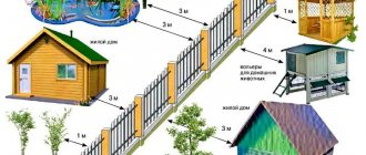
Layout basis and urban planning plan
When conducting alignment networks, red lines are taken into account - the boundaries of public areas: roads, driveways and sidewalks that are not subject to development. To ensure correct compliance with heights, it is necessary to verify the height at any point of the building under construction using no less than two geodetic signs. The direct beam between the signs must pass at least 0.5 meters from the surface of the ground and the walls of buildings.
The basis of construction is the master plan of the territory, which, as the scale increases, is divided into element-by-element master plans.
Read also: Fishy smell from the groin of women
The set of documentation developed for the preparation of construction is coordinated with the department of architecture and urban planning of the municipal district (district) within whose borders the territory will be developed.
By agreeing on the geodetic basis plan, the Department of Architecture and Urban Planning assumes part of the responsibility for protecting public interests.
The main requirement for any construction is compliance with the red lines. In the event of an error or dishonesty of the architectural management, a legal dilemma arises: the demolition of a building that goes beyond the red line, or the transfer of the red line and the transfer of public territory. In the first case, it is inevitable that compensation will be paid to the owner of the building if the building has to be demolished due to the fault of the regulatory authority that approved the plan with violations. In the second case, you will have to build a road (passage) in a new place, which may mean even more expenses.
The consequences of violating the design of the geodetic basis and its arrangement on a construction site can be quite serious, up to refusal to put the building into operation or declaring the building unsafe if failure to comply with the heights gives rise to an unacceptable slope of the building. Violations of planned (horizontal) parallels can give rise to distortions in the distribution of load on the load-bearing elements of the building.
When constructing multi-storey buildings and complex building complexes, the geodetic basis must also be approved by organizations providing water supply and sanitation, since the height of buildings imposes a limitation on the possibility of water supply and may require the creation of additional pressure.
The design of the geodetic basis must therefore take into account:
- Physical characteristics of the area.
- Technological capabilities for connecting buildings.
- Legal regime of plots and their boundaries.
The last point may be more difficult than the first two.
Acceptance procedure
The acceptance method consists of comparing the provided geodetic alignment basis with existing designation standards, permissible errors, and rules for schematic display of objects.
In addition, it is taken into account whether such schemes solve existing problems and achieve their intended goals .
For example, the alignment network should be created to ensure the possibility of setting out the axes.
Similarly, the external alignment network should display existing parameters and allow them to be transferred to the real world in such a way that they exactly correspond to the designated coordinates.
Some of the requirements contained in the acceptance procedure are as follows:
- The main control points must be secured with four signs - no less than two on each side of the structure;
- When placing paired signs, the requirement for the permissible distance between them must be met - from 15 to 50. For linear objects, this norm is slightly higher - a distance of up to 100 meters is allowed;
- When constructing a group of buildings that will be located separately from each other, it will be necessary to show two benchmarks for each of the designed buildings , and the distance between them should be in the range of 200-300 meters;
- In the process of drawing up a geodetic alignment base, it is allowed to combine benchmarks with axial marks - such a factor cannot become a reason for refusing its acceptance.
Layout networks made using a level
Layout networks are required to secure them on the site using benchmarks.
In practice, two methods are used for construction:
- Closed leveling passages.
- Polygon systems.
Benchmarks secure the bases of points. Their installation is carried out to transmit elevation marks to an object with several signs.
It is worth knowing that visibility between adjacent signs is maintained when constructing networks. When taking measurements from the sighting beam, the main requirements are that it should pass at least 50 cm from the ground.
Requirements when laying leveling signs:
- If possible, points of the planned and high-altitude networks should be combined.
- It is better to install signs in structures built at least 2 years ago.
- When laying benchmarks, take into account the presence of groundwater so that the groundwater is not displaced. It is advisable to excavate areas where groundwater does not flow.
When carrying out measurements, it is necessary to maintain accuracy, which differs from the characteristics of the terrain and OKS, but the limits of permissible errors must be taken into account.
Survey
The survey of the geodetic alignment base is carried out in the process of signing the relevant act. Such a document must include the following information :
- Data about the construction site for which the breakdown was carried out;
- The name and exact address of the site where the construction of the facility will be carried out;
- Customer's name. If it will act as a legal entity, the OGRN and TIN are also indicated;
- Information about the organization acting as a contractor;
- Information about the person who carried out and was responsible for the process of preparing the construction project;
- Name of the organization performing the construction of the gas distribution facility;
- Number and date of the survey;
- Position and full name of the person acting as the customer’s representative;
- Name of the body exercising construction control regarding the designed facility;
- Data that the documentation was studied and that an actual comparison was made with those signs that were fixed directly on the ground;
- A note that the signs have been tested for compliance with state technical regulations;
- Additional information that may be significant for the construction project under construction;
- Reflection of the number of copies in which the geodetic alignment basis was compiled;
- Signatures of persons present at the examination.
Only after the inspection certificate is signed will the projected construction facility be allowed to begin construction.
Answers to questions on the topic
Question : Who ensures that the geodetic alignment base is brought to the site? Answer : The responsibility for bringing the gas distribution facility to the site falls on the shoulders of the developer (customer). An intermediary who has a certificate of admission to the relevant work acts on behalf of the developer.
Question : Who maintains the as-built documentation for the facility under construction? Answer : An inspection report, axle alignment, inspection of hidden work, critical structures, sections of engineering support networks - all this must be prepared by the organization that directly carries out the construction.
Question : What tasks do the customer and the contractor face in performing gas and gas exploration? Answer : The customer creates the gas distribution center and secures the main axes on the ground. The contractor accepts these works in accordance with the act. The contractor is responsible for the safety of the gas and gas distribution, and the customer checks the gas and gas distribution.
Question : What is the cost of developing a gas distribution facility? Answer : As of 2021, the cost of geodetic work for the creation of a gas distribution center starts from 80 thousand rubles. for 4 reflective signs.
Without a geodetic alignment basis, the construction of any capital construction project is impossible . GRO refers to the installation of a grid of geodetic signs at points with certain coordinates on the construction site.