Land surveying is the determination of the coordinates of a plot of land by cadastral engineers and surveyors using special equipment. Is it necessary to carry it out if you own a piece of land in a gardening partnership? Looking ahead, let’s say that the law does not oblige you, but for your own peace of mind, carry out a survey of the SNT land plot and be sure to draw up the appropriate documentation for it. This will help you avoid disputes with neighbors, as well as legally sell the land if necessary.
Land requires legal registration to avoid possible troubles
Why is the procedure needed?
The situation with gardening plots is as follows.
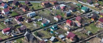
The state allocated one large piece of land to an association of gardeners - a partnership (or cooperative). This is public land. The partnership divided it between the owners, who erected fences and conveniently forgot who, when and where wrote down the coordinates of the borders. Time passed, and the neighbor decided to put up a new fence, and 50 centimeters further than the old one stood. How to make him return to his original place? Look in the documents at how the border of his allotment is. What if there are no such documents? The delineation of public lands in SNT, divided into plots between owners, is precisely intended to protect the owners from encroachments on their property. If the boundaries are not documented anywhere, you will not be able to prove anything. The fact that you have fenced your territory does not give you the right to claim that it is yours.
data-matched-content-ui-type=”text_card”
The state pursues its goal - recording land plots. How else can we count them?
Are SNT obligated to demarcate PDOs?
Carrying out cadastral work to clarify the boundaries of land plots on the territory of SNT is mandatory. However, this is only relevant in a number of cases:
- It is planned to conclude a transaction with land - purchase and sale, will, etc.;
- Proceedings in which it is necessary to provide proof of rights to the site;
- There is a need to unite or divide the territory;
- A plot of land in a particular SNT is of high value;
- The owner needs to determine the exact area of his plot;
- Correction of errors in cadastral registers is required.
The management of SNT does not have the legal right to independently initiate measures to survey the territory. All land is not the property of gardening, so nothing will happen without the consent of the owners to the procedure. However, it is in the interests of land owners to entrust land surveying to the management of the partnership.
The owner will receive a lot of restrictions on the disposal of property if the site is not demarcated. The land plot cannot be sold, donated, etc. Regarding territories that are considered common, demarcation can only occur if there is the consent of the majority of owners of plots in the SNT.
When it is not necessary to legitimize boundaries
When you simply use the allotment that was once allocated to you. According to the law, if the territory is not demarcated, it can continue to be used. But no legal manipulations can be carried out, that is, selling land, renting it, donating it, etc.
PDO land surveying may not be carried out if:
- you are satisfied with everything and do not need to take legal action regarding the land. You can continue to conduct your activities there, because ownership allows this;
- there are no disputes with neighbors, there is no risk of being deprived of part of your land, then you also don’t have to survey the plot;
- there are no plans to build a house on a piece of land that you own.
How to get a free survey
Those citizens who have not yet registered their land plot are most interested in receiving a free service and how much land surveying costs in 2021. According to the new law, they can do this free of charge until December 31, 2020 in the following cases:
- The plot is leased or purchased from the city municipality. In this case, local authorities pay for the procedure.
- The survey will be carried out within the framework of a comprehensive cadastral quarter, during which the process is carried out for all plots that belong to it. This is done in order to increase land tax collections, as well as reduce the amount of unregistered land.
- If the land plot is covered by the “dacha amnesty”, the period of validity of which ends on March 1, 2021.
- After the amendments, free land surveying is provided to large families in need of improving their living conditions, as well as newly formed plots.
Large families have the right to free land surveying Source yandex.net
The regulatory framework for large-scale complex land surveying has been registered, however, so far the city authorities have not officially approved the groups of the population who are entitled to this service free of charge, nor have they allocated budgetary funds for its implementation. Because of this, many municipal lands are still issued to citizens without prior land surveying.
This situation is extremely unfavorable for citizens. The law came into force a long time ago, however, local authorities are in no hurry to implement it. Therefore, people have to carry out the procedure at their own expense and become registered in the cadastral register.
To get a land survey, you need to contact the local municipality or the Ministry of Property Relations in the region. As for complex land surveying, you can also obtain information about whether a site is included in the queue for boundary determination from these structures upon written application.
Information on comprehensive land surveying can be obtained from the Ministry of Property Relations in the region Source yandex.net
When to Define Boundaries
Land surveying of SNT land is necessary primarily when resolving disputes between the owners of neighboring plots. It is not uncommon to have disagreements over small pieces of land, and everyone wants to resolve them in their favor.
Other options when you need to survey a section of SNT:
- if new plots are formed in the partnership on land that is not owned by anyone;
- one of the owners of the plot wanted to legitimize his part of the land (allocate a share);
- if several plots are planned to be combined into one;
- you want to sell or rent out your land;
- so that there are no problems with entering into ownership by inheritance;
- when building on land you own.
In these cases, land surveying comes to the rescue, and thereby legitimizes the land.
Legislative regulation of the issue
Federal Law No. 66-FZ of April 15, 1998 “On gardening, gardening and dacha non-profit associations of citizens” is a document that defines concepts and regulates relations in SNT.
The law provides for the possibility of owning a land plot that is located on the land of the partnership. Registration of the treasured acres into individual ownership is not excluded.
This means that in order to carry out transactions with land plots (sale, donation, inheritance), a cadastral plan and registered boundaries of the plot will be required.
On July 29, 2017, the president signed Law No. 217-FZ “On the conduct of gardening and vegetable gardening by citizens for their own needs and on the introduction of amendments to certain legislative acts of the Russian Federation", which will come into force on January 1, 2021.
This legislative act amends the current legislation and determines the prospects for the development of gardening and vegetable gardening associations.
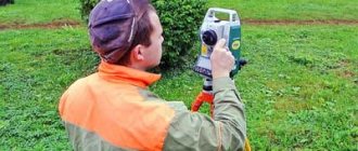
Surveying professionals
The land surveying procedure is carried out by a cadastral engineer and surveyor to determine the exact coordinates. They must have a license that provides the right to record land.
You can find a specialist using the Rosreestr website. The search procedure is not complicated. On the website you can check all engineers for certificates and licenses. Whether the engineer is an individual entrepreneur or represents some kind of organization, how many positive and negative decisions there are regarding his work, and much more. Before signing an agreement with a cadastral engineer, read reviews about him on the Internet. Because if the choice is unsuccessful, the site may be poorly demarcated and not registered. The end result is a waste of time and money.
The price of surveying varies from 5,000 rubles to 35,000 rubles. It all depends on the region, area, complexity of the site geometry and other factors. In municipal authorities, the cost is calculated based on labor intensity using special formulas and is cheaper. In private organizations, entrepreneurs themselves set the price depending on demand. When signing the contract, you can agree on advance payment terms: half the cost before the start of work and half after.
Is it necessary to do this if you have a gardening book?
Do I need to survey my garden plot if I have a gardening book? It depends on the situation. From the point of view of the law, no one can oblige the landowner to carry out this procedure without reason.
It is planned to separate from the common property, sell, or some other legal action - this is all for which land surveying of the garden plot is necessary. The gardening book does not contain such data that can be obtained exclusively from land surveying.
Is it necessary to carry out land surveying of a garden plot if there is a cadastral passport? At the moment, even a cadastral passport is not such a universal document that allows you to avoid this procedure.
Although increasingly, when requesting a cadastral passport, a requirement is made for land surveying. Starting from 2021, it will take a single form, which will contain:
- number;
- type of allotment;
- dividing lines, turning points;
- geographical coordinates;
- description of the site;
- number of square meters;
- grounds for registration as private property;
- information about encumbrances.
But this is in the future. At the moment, even many cadastral passports do not contain data on the boundaries and turning points of the site.
Having received a cadastral passport, the landowner applies to the Registration or Cadastral Chamber and provides it along with the survey file.
After the documents have been verified, they will be returned to the owner and a certificate of ownership of the land will be added to them.
Thanks to the land surveying procedure, it is possible to draw up boundaries and formalize them. But what documents are needed for this - read on our website.
Stages of work
Step 1. You must write a statement to the organization about your desire to survey the SNT land plot, attach a copy of your passport, technical specifications, which are signed by the owner of the land.
Step 2. Before starting the land surveying procedure, you need to collect documentation:
- extract from the cadastral register;
- a document that can confirm that you are the legal owner;
- site drawing;
- SNT scheme certified by the gardening partnership;
- information about geodetic marks (if this is an old site);
- list of interested parties (neighbors or head of the partnership).
Step 3. An agreement is signed with the engineer or the organization in which he belongs.
A date is set for surveying the SNT land plot. Step 4. A cadastral engineer and a surveyor arrive with special equipment. A work project is being created. It describes the goals of land surveying, stages of work, drawings of the site, and writes out an act of approval of boundaries. Geodetic survey usually lasts 1-3 days, depending on the territorial distance, geometric complexity, weather conditions, time of year and other factors. The survey uses the most modern instruments that can measure the territory down to the centimeter. Theodolites and levels made in Japan are used.
The permissible error for rural areas is 20 cm, for urban areas 10 cm. This is exactly what the surveyor must keep within. If the error is greater than the permissible threshold, then the surveying of the SNT land plot will be declared illegal
Surveying the PDO will require a sufficient amount of time. It takes about a month to prepare the documentation and sign the contract with the engineer, plus the result of the approval of boundaries will also have to wait about a month.
Persons who are interested in determining the boundaries of their territory must be notified of the land surveying procedure. The notification is sent 7 days before the survey; whether to appear or not is the decision of these persons, but notification is required. At the stage of land surveying work, all interested parties must be personally present when signing the act. If someone was not present, a repeat meeting is scheduled. If they fail to appear again, the document is legally drawn up and signed without them.
Order of conduct
The procedure for establishing boundaries for lands that are part of the SNT is somewhat different from that used in relation to areas owned by one person or organization.
This fact is due to the fact that the plots do not have a sole owner and all organizational processes can only be carried out with the consent of the users of the plots.
General meeting and conclusion of the agreement
Since the survey procedure will be applied to lands included in the SNT and payment for the provision of such a service will be charged to each user of the site, the decision on the need to establish the boundaries of plots and public lands is also made by all persons with the right to vote .
To make such a decision, it is necessary to initiate a general meeting, at which, through a general vote, a decision is made both on the possibility of initiating the procedure for establishing boundaries, and on which organization will need to be contacted in order to carry out the survey.
At the meeting, the goals of land surveying, the conditions for working with a certain geodetic organization, as well as the price of the procedure, both in general and divided for each of the land users, are announced.
The decision in such a situation is made on the basis of the quorum provision and decision-making (the necessary preponderance for the possibility of approving a particular action).
Required documents
In order to be able to contact a geodetic organization and initiate the determination of the boundaries of the site, it will be necessary to prepare in advance a package of documentation required in such cases.
So, in particular, you will need :
- Documents that indicate the right to use the site or obtain it into ownership;
- Documentary evidence of the existence of ownership rights. This may be a certificate of receipt of a plot issued by the local administration, as well as a purchase and sale agreement or other document that can serve as the basis for the exploitation of the land by any person;
- The general scheme of the partnership, which will be certified by the board. These materials can be used for direct land surveying; in particular, the engineer will be guided by the information when determining the boundaries of the land that will need to be included in the land survey plan;
- Minutes of the general meeting of the partnership at which the current chairman was appointed.
Carrying out geodetic work
Geodetic work is the main part of determining the boundaries of the plots that are part of the SNT, as well as the boundaries of public land.
The engineer must first familiarize himself with the available documentary data regarding such territories and take into account all information about the coordinates of the boundaries that is available. A specialist can take the available data as a basis for further calculations.
After the calculation stage is completed, the cadastral engineer goes to the territory where the plots occupied by SNT are located and carries out work on the ground . Such work consists of directly drawing out the boundaries in nature and determining the correctness of the calculated coordinates.
, the features of the nature of the territory and the location of natural objects on them are first taken into account , and therefore it will be necessary to slightly change the location of the turning points of the land plots.
Once all milestones have been established, boundaries will need to be agreed upon.
Moreover, in the event of disputes regarding any of the borders, experts advise resolving such issues through a peaceful agreement , since otherwise the only option for solving the problem will be to appeal to a judicial authority, where, based on the documentation provided, a decision will be made on how exactly the process will take place. border.
Collective surveying in SNT
Collective plots - they are used by all participants in the garden partnership, and they do not belong to anyone personally:
- roads;
- bodies of water;
- structures;
- driveways.
Carrying out the land surveying procedure on collective plots will require a lot of time and money. Sometimes the procedure drags on for years. And for a positive result, it is important to turn to professionals in this matter.
So, land surveying of the SNT site is not necessary. But according to the law, if it is necessary to carry out legal transactions with it, that is, sale, lease, donation of land, then it is necessary. An important point is to choose a professional who will help you legalize the territory. The procedure for determining boundaries will make life much easier for those who have constant misunderstandings with the co-owners of the plot.
Video description
Legal advice on land surveying issues in this video:
Changes in legislation
Initially, all cadastral work was regulated by the Federal Law adopted back in 2000. However, it turned out to be ineffective and did not bring the expected effect - less than a third of all lands in the Russian Federation were officially registered in the cadastral register over eight years. Due to these indicators, the old law has lost its force.
Land surveying has always been a rather complex and costly procedure. However, since 2015, amendments were made to the Federal Law, which obligated local authorities to allocate money from the budget to provide this service to the population free of charge. According to the amendments, from 01.06.15 to 31.12.20, land surveying will be carried out by state cadastral engineers absolutely free of charge.
Until 2021, land surveying by state cadastral engineers is carried out free of charge Source yandex.net
And from January 1, 2021, land owners who have not undergone land surveying and, accordingly, have not entered their lands into Rosreestr, will not be able to carry out any transactions with them. Also, from this moment on, the service will become paid, so registration with the cadastral register will incur additional financial expenses.
Features of project preparation and site maps
When carrying out land management work on a territory that will later be divided into several plots, a special document is left - a land surveying project. This also happens when surveying land owned by SNT.
To order boundary work, you first need to obtain permission from local administrative authorities , issued in the form of a resolution on the allocation of territory for the use of a gardening partnership.
Based on this, the organization is obliged to carry out boundary work on the received land, as stated in paragraph 4 of Article 39.10 of the Land Code of the Russian Federation. The plan and map of the plots obtained during the research is the basis for further delimitation of lands by the owners of the plots included in the SNT.
The drafting is carried out in several stages :
- decision-making by administrative authorities on the use of certain lands in the SNT;
- preparation of a land surveying project by an authorized company;
- coordination of the received plan with the local administration;
- if necessary, making corrections to the boundary plan;
- approval of the document by territorial authorities.
Only after drawing up such a project and its approval, a specific plot located on the territory of SNT can be allocated to gardeners, as reported in paragraph 3 of Article 11.3 of the Land Code of the Russian Federation.
The graphic section of the general land boundary plan of SNT consists of :
- public lands highlighted with a red line;
- points indicating the maximum proximity of the site to the boundaries of the PDO;
- boundary lines of areas included in the SNT;
- turning points with the designation of their coordinates;
- designated zones designating roads, driveways and other objects of the category of public easements.