The land survey plan appeared quite recently, as a replacement for the cadastral passport.
It has a similar structure and is regulated by Federal Law 218-FZ of 2015 “On State Registration of Real Estate”.
The plan contains information that is entered into the EGRN (Unified State Register of Real Estate).
This means that all data about the territory that is entered into the Rosreestr database is presented in this document.
What is it and what does the document look like?
There are two types of land survey plan: paper and electronic. A paper version is issued after the boundary determination procedure . One option remains with the land owner, the second - you need to transfer it to the state cadastre department to enter the data contained in the document.
The paper plan consists of several (the number is different in each case) A4 pages. If drawings and diagrams do not fit within the boundaries of the sheet, then they can be executed on larger paper. All pages are stitched.
The title page indicates:
- number of pages of the boundary plan;
- the purpose of performing cadastral work;
- information about the customer of the work (owner of the land plot);
- information about the cadastral engineer;
- number, date, signature of the cadastral engineer, seal of the organization where he works.
The cadastral engineer also places his signature on the reverse side of the last page of the boundary plan.
If it looks like an electronic document, then it is certified by the electronic signature of a cadastral engineer and is also transmitted to the cadastral registration authorities.
Why do you need a boundary plan for a plot of land?
When making any transactions with real estate (sale, donation, will, etc.), clarifying the boundaries of the land plot, changing the address of the land plot, you need a cadastral passport, which is the main document for cadastral registration. The required document to obtain a cadastral passport is MP.
The reasons for creating or updating a MP may be:
- formation of land plots from state or municipal lands;
- combining several adjacent storage units;
- dividing the memory into several parts;
- allocation of land plots from common property;
- redistribution of storage;
- clarification of the boundaries of the memory;
- correction of cadastral error.
Depending on the reason for which the MP was created, there are seven main types of boundary plans.
Content
Let's consider the contents of the boundary plan based on the boundary plan of the garden plot. In this case, it contains 12 pages (including the title page, table of contents and legend).
Each case of determining the boundaries of a site is unique . In some cases, the plan is being drawn up for the first time, in others it is necessary to change the data. In accordance with this, the amount of material and pages changes.
a common part
The general part indicates:
- 1 and 2 pages: title page plus table of contents.
- Information about the site. If we are talking about combining or dividing a plot, then the description records part of the plot or several plots. Usually this is page 3.
- The following are the measurements that have been carried out by the cadastral engineer at the moment. This page follows the original site information.
- Next comes information about the areas being formed or changed, as well as its parts. These pages are not always present.
- The following provides information on the coordination of plot boundaries. All references to acts of approval of interested parties must be conveyed using the details of these documents.
This is the so-called text part . The following pages are filled with drawings and plans, an example can be seen in the photo.
Technical information and graphical diagrams
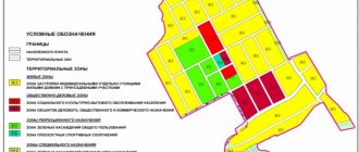
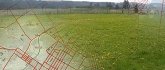
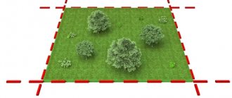
The graphic part must contain the location of the borders.
Here the location of the site on the map relative to others is indicated graphically.
The graphic part may contain:
- boundaries of the merged lands;
- boundaries of parts of the site;
- access to the site.
The technical part of the boundary plan is drawn up using symbols , which can be found at the end, on the last page. If necessary, the plans and drawings indicate the boundaries of municipalities, settlements, cadastral divisions (districts, blocks).
The scale should ensure the readability of the map.
boundary plan of the land plot can be found at the link
How to obtain a document from Rosreestr
The boundary plan contains complete information for cadastral registration and one of its copies must be kept by the owner of the land plot.
Previously, documents were transferred to the State Property Committee (GKN) (State Real Estate Cadastre). Now, with the formation of Rosreestr, all paper or electronic copies are transferred there. The State Cadastre is now a subordinate organization to Rosreestr.
If documents are lost, copies can be issued . Often such a need arises when selling a plot of land, starting construction, installing a fence, a dispute with neighbors regarding boundaries, erroneous cadastral information, or disagreement with the amount of tax. The reasons may vary.
In order to receive a paper or electronic version of the land survey plan, you need to contact:
- To the local cadastral office . If the survey was carried out a long time ago and an electronic version of the document does not exist, then upon request, a copy is made from a paper copy. When issuing such an electronic copy, the source is indicated.
- MFC or My Documents office . These structures are intermediaries between federal authorities and the population. All documents are processed according to the “one window” principle, when there is no need to run around looking for the right office.
- Through the official website of Rosreestr.
The boundary plan is issued to plot owners, so to obtain a copy you will need the following documents:
- Passport . If the owner is represented by one of his relatives or friends, then a notarized power of attorney and identification will be required.
- Statement . Issued on the spot.
- Certificate of ownership or extract from the Unified State Register of Real Estate.
If a citizen is not the owner of the plot, then he must present papers that prove the fact that the authorities allocated the plot to this person.
You must pay a state fee for a copy: 800 rubles for a paper version and 250 for an electronic version.
Surveying process
In order to begin carrying out boundary work, the owner must prepare papers for this. Usually, all that is required is a citizen’s passport and a document that would confirm land rights. It will be necessary to find specialists who will take measurements and survey the plots. In such situations, you should contact the BTI (technical inventory bureau), where for a certain fee, since land surveying is a service provided by government agencies, the prescribed measures will be carried out.
The land surveying procedure involves going through several stages, which include the participation of both the land owner and specialists:
- Preparatory stage. It is here that the owner collects documents, negotiates with neighbors if necessary, and selects specialists for the work.
- Inspection and study of the boundaries of the site, adjacent territories and their features. Designation of existing signs to determine their future fate.
- Developing a plan. It will reflect the step-by-step actions of specialists, which will be aimed at obtaining all the important information about the site.
- Notifying neighbors and all those who are interested in carrying out this work. Moreover, no work can begin without the participation of the owner himself or without his permission. This is an important rule, since not only the owner, but also another person can order land surveying.
- Geodetic survey of the territory and the formation of the obtained data, their processing and full analysis.
- Preparation of final documentation. You need to make sure that all papers are signed by authorized persons.
- Transfer of the survey file to the cadastre service, which, within about five days, based on them, will draw up and issue to the applicant a cadastral passport, which is an integral part of the technical documentation of any plot.
To carry out all of the above actions, it will be necessary to attract diverse specialists. These are cadastral engineers who carry out measurements and surveys of the territory, and geodetic workers who carry out surveys, and employees of the cadastral chamber.
After being transferred to the archive, the survey file must be registered and included in the register of information, otherwise it will not be recognized as valid.
In order to decide which specialists to contact, you first need to choose an organization. These can be private independent companies that have received a license for this type of activity, or government agencies. It is also important to pay attention to the education and qualifications of the performers, since mistakes are often made during measurements and inspections, and in thirty percent of cases there is not even a visit to the territory.
Thus, land surveying is a set of documents that contain the necessary data about a specific piece of land. Without it, it will be impossible to register the right to the plot, as well as to dispose of the plot in the future, including through concluding transactions.
How to look on a public cadastral map
You can view the land survey plan using the Public Cadastral Map. In the search window, you must enter the cadastral number or address of the site. After this, you can view the plan in the “Information” section.
The information obtained from the cadastral map is free .