Is the procedure for verifying boundaries mandatory, in other words, is land surveying of a summer cottage mandatory or not? And if it is necessary, then at whose expense is this banquet? The people (dacha residents) have long been accustomed to the fact that the state seeks to implement any administrative initiatives at their expense. Moreover, it makes such actions no alternative when maintaining the status quo becomes impossible without another “re-registration”.
For a gardening non-profit partnership, a fair division of property between its partners (namely, land) is the key to long-term good neighborly relations. In fact, everything is much deeper and we are talking about respecting land ownership rights. Compliance with this right is controlled by law.
The state generates a huge problem related to the unconditionality of property rights. A situation arises in which the owner wants to sell his plot, but cannot. In some cases, it is not even possible to pass it on by inheritance. Ownership gradually becomes conditional
Why should you survey your garden plot?
In one word, this is necessary for personal peace of mind! Land area is such a thing. You always feel like you're the master of your own land... until someone comes up and asks you to get off their land. This is fraught with litigation. But it can be avoided. To do this, you need to document the boundary of the allotment.
data-matched-content-ui-type=”text_card”
In addition, there are other reasons:
- If it is intended to carry out any legal actions with the land plot (such as donation or sale), then you will need to confirm ownership (or privatization). According to modern rules, it is impossible to obtain an extract on the condition of the property without conducting a land survey.
- If the owner did not use the plot of land for several years and did not even visit it. And then he arrived and saw that a significant part of it was being used by a neighbor (for example, for potatoes). Then the only way to resolve the issue in a civilized manner is a land surveying procedure and a trial based on its results with the “invader.” First, in an amicable way, but if it doesn’t work out, then in court).
However, the procedure can also provide some advantages and benefits to those who carry it out on their own:
- Obtaining permission for individual housing construction is significantly simplified. Then, from the point of view of the law, there is confidence that the formed capital structure at the time of construction does not affect anyone’s interests. Otherwise, you will have to provide a full history: who owned it, when, plus provide the history of the cards.
- Gives the legal (!!!) right to carry out so-called “additions” (in the amount of up to 10% of the existing plot) at the expense of lands that do not belong to anyone. And they are not prohibited for individual housing construction.
In addition, if land surveying is not carried out, the Federal Tax Service sends out notifications to the owners of such plots about the need to register these “territories” as objects of potential taxation.
Why is land surveying needed?
Many land owners live quietly without land surveying.
Due to the high cost and complexity of the procedure, many do not decide to do it unless absolutely necessary.
However, there is a list of situations in which land surveying will need to be carried out:
- for sale or donation of land;
- for renting out a plot;
- for organizing capital construction on a site (and not necessarily a house, we can talk about an extension or a bathhouse);
- during disputes with neighbors about the ownership of certain plots of land;
- when dividing or merging several areas;
- when allocating land from a collective property plot.
In case of a territorial dispute with neighbors, conducting a professional geodetic survey is perhaps the most effective way to resolve the conflict.
When constructing any buildings, especially long-term ones, it is also advisable to carry out land surveying, otherwise you may inadvertently go beyond the boundaries of the site - and this can lead to serious fines and significant hassle.
When it is not necessary to produce
So, surveying public lands in a gardening partnership is a useful procedure and, in some cases, even fraught with some bonuses. However, there are cases when this administrative action is redundant:
- Not required for those land plots that are registered as a result of the “dacha amnesty”. The amnesty is already carried out on the basis of topographic survey data, and therefore the new owners are not required to once again “push” the limits of their legalized “squatting”.
- Utility and summer cottage plots also do not require land surveying.
- And besides, this procedure is not required for those users of land plots who do not have ownership rights to them, but own them for life and free of charge. True, if neighbors encroach on this plot of land, the court (for example, if the case goes to court) will demand from the neighbors documents on land surveying. In this case, it is better to play it safe and carry out the procedure anyway (fortunately, it is not prohibited).
Legislative regulation of the issue
After a detailed study of this issue, we can conclude that this procedure in relation to the dacha area is quite a serious and relatively mandatory step to implement.
legislative acts make this process “mandatory” and desirable for implementation :
- Article 218 of the Federal Law (this act describes the procedure for registering real estate);
- Article 221 of the Federal Law (this document includes the procedure for cadastral registration of so-called isolated territories);
- A manual printed by Roszemkadastr (in the form of a small book, it contains all the necessary information about the procedure and principles of land surveying of a summer cottage).
Who should carry out the procedure
Before purchasing a plot, you should pay attention to whether the seller has properly surveyed the SNT land plot (i.e., whether he has completed all the documents correctly). If not, but you still conclude a deal, then all problems with neighbors on the disputed property automatically transfer to you.
Also, you should not assume that the issue of confirming the boundaries of your site is the responsibility of the partnership represented by its administration - this is the responsibility of the owner of a specific territory exclusively.
And finally, it should be remembered that only a cadastral engineer has the right to draw up a boundary plan. He must have a license and clearance. Otherwise, the plan will be declared invalid.
What does the procedure include?
According to the same aforementioned Manual, the term “site demarcation” is the following formulation: the process of establishing clearly defined boundaries of the territory of the dacha. In other words, having carried out this operation, you, in addition to oral agreements, for example with your neighbors, will have in your hands a written (notarized) confirmation that the territory you are exploiting is yours and no one else’s.
After the process is completed, information about this operation will be immediately entered into the Unified State Register of Real Estate, which is necessary for the subsequent issuance of landholdings to other citizens.
It is worth knowing that if you do not take care of entering new data into the Unified State Register in a timely manner, you may face problems :
- Part of your land (vegetable garden) may be “attributed” to your neighbors, which will never happen if the registry contains data on the land surveying you carried out;
- You will not be able to take ownership (buy a house, dacha) until this so-called land survey is carried out on its territory (according to the current legislation of the Russian Federation, which gained legal force on January 1, 2021);
If you have a gardening book
A gardening book is a document proving that you are a responsible user of the land plot within the SNT. The main feature of such use is that you are not the direct owner of the land. Therefore, here are the possible options:
- You continue to decide to remain a user of the allotment. However, in this case, no transactions with the land are possible; it can neither be bought, nor sold, nor given away.
- You intend to privatize the land. In this case (just to perform this action) you will need to carry out work to determine the boundaries.
Deadlines
It is impossible to give specific deadlines, because if you, for example, provide an incomplete range of documents, your “application,” which is not strange, will require additional checks, and this takes time. On average, according to statistical data, a cadastral engineer carries out land surveying 7 to 14 days after contacting Rosreestr.
It would be appropriate to remember the price side of this issue.
Thus, the services of the Federal Cadastral Authority are not free: depending on the location of your site, the cost of the procedure will be about 2000 - 5000 rubles.
Public lands in ST
As mentioned above, the law allows for the “cutting” of public lands that do not belong to anyone when carrying out land surveying of a nearby plot. The standard for PDO land surveying is no more than 10% of the site area.
Which lands cannot be “cut”:
- Areas of protected areas.
- Public areas (for example, roads).
- Areas set aside as security areas when laying communications (for example, gas pipelines or electric cables).
If the site is registered
Many land owners believe that the presence of a cadastral passport, which contains data on boundaries, eliminates the land surveying procedure.
When receiving cadastral passports in different periods, the land surveying procedure was not always carried out; therefore, although such a document will be available, the information that will relate to the boundaries of the site will not be relevant or valid .
If you have a passport, surveying is required :
- If land surveying was carried out, but without taking into account the requirements of the Land Code of the Russian Federation (currently in force);
- If after the land surveying procedure the area of the site or its configuration has been changed;
- If a transaction is planned, and the passport was issued 5 years ago or earlier.
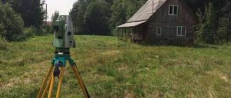
Features of measuring a site in SNT
The first and most important question that worries those who are planning to carry out the procedure for surveying the SNT site: should neighbors be present? Answer: neighbors need to be notified of the appointment of the land surveying procedure, indicating the time it will take place. This must be documented. Either this is a registered notification form or a telegram, but the one who notifies must have confirmation of informing the interested parties. Next, neighbors can appear for the procedure or be absent from it - this does not play a role in its results, and also cannot serve as a basis for canceling it.
But if the neighbors were not notified, then this may be grounds for canceling the results of the land surveying procedure!
Cadastral engineer:
- Performs boundary measurements.
- Determines the exact geographic coordinates of the vertices of the corners on the plan.
- Determines the area of the allotment.
- Draws up and provides the owner with a drawing of the land plot.
The actions of the cadastral engineer are activated. The act is signed:
- To those who own land (required to be present).
- A representative of the administration (presence if possible).
- Neighbors (presence if possible).
- The cadastral engineer himself.
Based on this procedure, a boundary plan is drawn up.
Service cost
Previously it was free, but today such a service costs a certain amount. To carry out this procedure, you need to contact cadastral engineers who are in every city. Such people are engaged in non-departmental activities, which means they set the price themselves.
To get the lowest cost of the service, you need to contact city services, but then you will have to wait for an engineer for a certain time, since there is usually a queue. The pricing policy is influenced not only by the cost of the site, but also by the territorial location and what category it belongs to. On average, such a service ranges from two to fifteen thousand rubles. But it is also necessary to draw up a technical plan, which also costs money, or rather about four thousand rubles, and you will also have to pay for typographic photography for about a thousand rubles.
In some cases, such a service can be obtained absolutely free, but this happens extremely rarely. For example, when holding an auction for the purchase of a plot or lease, the state pays for land surveying. If a plot of land falls into the zone of complex cadastral works. You can also get involved in federal activities that are aimed at reducing unaccounted for lands.
What documentation is required
In order for a cadastral engineer to come to your site, you should prepare and present to him:
- Certificate of ownership (a copy is sufficient) or a gift agreement. Simply put, you need a title document confirming your right to this site.
There are now many services that help citizens unlock doors if they have forgotten their keys. Of course, those who have forgotten, as a rule, do not have any documents with them regarding their ownership of the apartment. But they will definitely be needed when the door is open (otherwise the master will simply call the police). In the case of land surveying, the logic is the same: it is forbidden to survey someone else’s land!
- A passport is required.
To receive a ready-made boundary plan, you will need to provide:
- General plan of SNT (photocopy).
- Certificate for SNT (copy) – proof that this land plot is actually located on the territory of SNT.
- Minutes of the meeting of gardeners (copy) - confirmation of the validity of the signature of the chairman of the SNT.
- Extract from the Unified State Register of Legal Entities of SNT (copy).
Federal Law 447-FZ of December 22, 2014
Federal Law of the Russian Federation No. 447 “On Amendments to the Law “On the State Real Estate Cadastre” was adopted at the end of 2014, the latest editions will be in 2021 . We are talking about amendments to a legal act that was published in 2007, Federal Law No. 221 “On the State Real Estate Cadastre”.
Changes
The following changes have been made to the legal decree that regulates cadastral activities :
- The time frame for cadastral registration has been reduced from 10 to 3 days.
- The system for correcting errors in the cadastre has been streamlined.
- The new chapter (Chapter 4.1) is devoted to complex cadastral work. These are free works that are carried out on the territory of a cadastral quarter or several adjacent ones.
- The period for state registration of rights has been reduced to 10 days.
All changes were developed after analyzing cadastral activities for previous years. They are aimed at improving the efficiency of cadastral registration .
Is defining boundaries a mandatory procedure?
Land surveying is not a mandatory procedure .
There are a number of dacha plots in SNT that have not been demarcated, but are registered in the cadastral register.
Ownership rights have been registered for such plots. In this case, they can be sold without further delimitation.
Land marking is also done when there are disputed boundaries with neighbors.
Before selling your own plot of land to someone, it is not necessary to carry out land surveying. But you need to understand that this procedure will increase the market price of your plot.
Collective land surveying in SNT
Collective surveying differs from individual surveying only in the number of those present. Drawing the boundaries of any one area, of course, affects the interests of neighbors (who would also, not a sin, carry out land surveying of their own territory). And this is where incidents occur related to notifying interested parties about the ongoing land surveying procedure.
By law, the notification must be sent with documentary evidence (registered mail or telegram). But it often happens that the owner-neighbor simply cannot be found - the letter is returned with the wording that the subscriber has dropped out...
In this case, it is necessary to submit an advertisement in the newspaper (about the approval). At least 1 calendar month must pass after publication. After this, you can set a date for the arrival of the cadastral engineer. Only with this sequence of actions is there a chance to avoid further appeals against the results of land surveying by neighbors who suddenly appeared.
Advantages of land surveying
Carrying out this procedure gives the owner of the site several advantages:
- Complete independence. The owner of the land can feel like a true owner; he will be able to dispose of the plot at his own discretion without the permission of the co-owners.
- Security. No one will be able to encroach on the demarcated plot of land.
- The territory is completely protected from foreign claims.
- Legitimization of the assigned territory. By law, the owner of a plot can increase his territory by 10% at the expense of no-man's land. This will not be considered an unauthorized seizure, but merely a clarification of the boundaries and adjustment of the area of the site. True, as the size of the plot increases, the costs of maintaining it will also increase - but that’s another story.
- It can be useful to carry out land surveying to ensure your own safety, for example, if mass construction and alienation of land begins in a populated area.
- Without documents in hand, a citizen will not be the owner of the land, even if he has lived on it for many years. Donation and inheritance of land will not be an argument either.
If boundaries are not established, such a tenant is considered an unauthorized invader of the territory, and neighbors or the municipality can easily take them away.
Thus, during the period of the “dacha amnesty,” many pensioners became victims of the tyranny of their own neighbors, who en masse transferred huge tracts of land into their names. Then they either lost their homes or suddenly became tenants on their own property.
Carrying out land surveying guarantees the integrity of the land and insures against all unforeseen situations.
Summary
Land surveying is a fairly easy procedure. Yes, it requires some actions on the part of the owner:
- We need to find the neighbors' addresses.
- You need to book the arrival time of the cadastral engineer (preferably 3 months from the current date).
- You need to send registered letters in which you notify your neighbors about the land survey.
- When and if some letters are returned without an answer, then you should immediately submit an advertisement in the newspaper (calling on the unfound neighbor to attend the land surveying procedure). It is for this reason that it is recommended to set a date for the engineer’s arrival no earlier than 3 months from the current moment.
- Carry out land surveying and obtain title documents.
Although there are a lot of actions, they are all spaced out in time, so we cannot talk about the “intensity” of the procedure. In addition, at the end, a prize awaits you - state recognition of your ownership rights to a land plot, secured by indicating the coordinates of the plot on the surface of planet Earth.
What documents are needed
To begin with, it would be logical to talk about where to submit documents that will serve as a “start” for starting the procedure for determining clear boundaries of the territory of your country house.
So, having decided that it is necessary to give your property over the site even more legal force, you must submit a corresponding application to Rosreestr (the nearest territorial office) , attaching the following documents :
- An extract from the cadastral register stating that your property actually has a summer cottage plot, which is the subject of land surveying;
- A document confirming that you are the full and sole owner of the property (house register, extract and Unified Real Estate Register);
- A document that will contain a list of coordinates of geodetic signs, if any were previously placed on the lands that now belong to you;
- A list of names of citizens of the Russian Federation (do not include yourself) who are interested in receiving a certificate of land surveying (according to the standard, they often include persons who are close relatives (husband/wife, son/daughter, father/mother).
It is worth noting here that the more extensive and reliable information is provided, the less time Rosreestr employees will need to check the data and send the appropriate specialist to your home to start working on your summer cottage.
Unfortunately, it's not over yet. After the cadastral engineer arrives, you will also need to conclude an agreement , to which you will have to attach:
- Application in free form for the provision of services;
- Work assignment (standard form, filled out based on the data you previously provided. You must check the accuracy of the information and sign);
- A copy of your passport as a citizen of the Russian Federation;
- Again, it is necessary to attach an extract from the Unified Real Estate Register;
- A certificate stating whether there are permanent buildings on the territory of the country house (as a compromise, instead of this certificate you can provide a copy of the book home).
Now, an agreement can be concluded directly with the “worker”, and the work itself can begin.