It reflects information about current buildings and the layout of the site, and enters data about planned buildings.
It is important to correctly draw up a planning organization scheme to obtain a building permit in accordance with building regulations and fire safety requirements.
What it is?
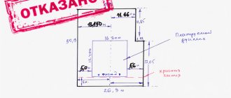
SPOZU is a diagram of the planning organization of a land plot. This is a project that records existing buildings and data about the site. It also contains information about the planned buildings.
The diagram is the result of a topographic survey, the scale of which is 1:500. The plan records the following data:
The boundaries of the site according to the title document.- Future capital construction facility.
- Existing facilities.
- Functional areas.
- Passages and driveways.
- Communications connection plan.
- Buildings that are planned to be demolished.
The SPOSU is prepared together with the general plan of the area. The document includes not only text, but also graphic parts.
The image reflects the location of the house, landscaping elements, communications, and site boundaries. The rational use of objects that are planned for construction in a certain area is described.
What is it for?
If you plan to build a house or other capital facility, it is important to prepare a complete set of documentation . The diagram is the main element.
It is on its basis that the architectural department of the local administration makes a decision on the possibility of construction. The SPOSU is necessary to ensure the correctness of the design.
The building must be located within the property owned by the owner. In this case, it is necessary to maintain indentations from the main objects - a residential building on a neighboring site, a fence, and other buildings. If violations are identified, modifications are made to the project.
For what objects?
You can make the SPOZ yourself or you can turn to a specialized company for help. It is necessary to prepare an image of the future house on the site, positioning it correctly. At the same time, a detailed description of its parameters is being prepared.
SPOSU is required to achieve the following purposes:
- construction of permanent buildings;
- reconstruction of the building;
- additional development of the territory;
- making changes to the construction project;
- changing the location of the facility before the start of construction work.
In each case, it is necessary to take into account legal requirements, urban planning plans, and building regulations. Only then will the construction be safe for others and the owner of the site.
Scheme of planning organization of a land plot for individual housing construction: features
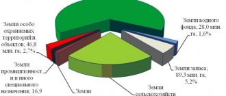
According to the above standards, it is required to enter into the designated document not only information about the location of capital construction projects and others limited by the territory of the allotment. Since the plot is included in the development zone of the urban planning context, it can be succinctly included:
- to the historical zone of the settlement;
- to the environmental protection zone;
- into the sanitary zone, including by creating its gap;
- on the territory encumbered with a public easement.
These and similar nuances that make up the parameters of the memory, according to the requirements, must be included in the SRAM without fail..
Requirements for the content of OSD
When preparing the scheme, it is important to be guided by the requirements of Article 48 of the Town Planning Code of the Russian Federation.
The SROM includes the following data:
- Built-up area.
- Total area of the site.
- Building density coefficient up to 0.4.
- Building height.
- Area of a residential building.
- Number of floors.
- Total area including all floors.
In addition to the descriptive part, the following data is displayed:
- boundaries of the land plot;
- boundaries of the planned building;
- indentations from the walls to the boundaries of the site (3 meters to the neighboring territory, 5 meters to the road);
- size and location of the house.
Edits are allowed, but they must be in a specific format. But in this case, it is necessary to put next to the correction the inscription “Believe the corrected one.” To avoid misunderstandings, it is better to immediately prepare the document without errors.
Where to order SPOZU?
If desired, you can significantly reduce time costs and avoid the inconvenience associated with the preparation of such documents. To do this, you will need to contact professionals who will perform all the necessary actions and prepare the document in such a way that it complies with state requirements.
If you need to prepare a SPOZU, contact the specialists of KB-Real Estate for advice by phone: 8. Our specialists provide professional assistance in geodesy and measurements, and have all the approvals and licenses that may be required in the process of performing work or conducting surveys.
Who can prepare and in what cases?
In accordance with paragraph 3 of Art.
48 of the Civil Code of the Russian Federation, the scheme can be made on your own if you are planning a house for one family without allocating separate apartments. In this case, the building cannot exceed 3 floors. In accordance with clause 4. Art. 48 of the Civil Code of the Russian Federation, if the types of upcoming work have an impact on safety, the participation of legal entities or individual entrepreneurs from among the members of the self-regulatory organization is required.
Such actions include preparation:
- master plan;
- planning organization schemes for the right-of-way of a linear structure;
- Schemes of planning organization of the route of a linear object.
The construction of an individual residential building does not apply to such actions. Therefore, the SPOSU can be drawn up independently.
What documents are required?
When preparing the SPOSU, it is important to submit documents to the district administration at the location of the site.
To do this you will need the following:
- Copies of cadastral passports for buildings.
- Cadastral passport for land.
- Extract from the Unified State Register of Real Estate.
- Title document for the site.
- Urban planning plan.
- Topographical survey with display of boundaries.
- Statement of the established form.
The owner also provides a copy of the survey file and a sketch of the house, if available. Documents are submitted to the administration, after which a decision is made on compliance with current requirements.
What you need to consider when preparing a SPOSU
In addition to the local administration to which you will submit an application, you may need to contact other authorities, such as:
- cadastral chamber (for land surveying if the boundaries of your site are not defined and you do not have a cadastral passport);
- MFC (to obtain GPZU as the basis for a future scheme);
- the main department of cultural heritage (to conduct a historical and cultural examination to prove that the land is not part of the cultural heritage and development can be carried out);
- sanitary-epidemiological station (your property may be located near water bodies or forests - such areas are often environmental protection areas, construction is prohibited on them, but you need to know whether there are such areas on your territory so as not to break the law).
If the site is located in the border zone, then you additionally need to coordinate the construction with the neighbors, receiving written confirmation from them that they are not against it.
Compound
The diagram includes two parts - text and graphic. Preparation of the text part includes:
characteristic features of the site;- justification for the planning organization of land;
- description of landscaping elements;
- description of the relief;
- technical and economic indicators;
- functional meaning;
- location of transport communications.
The graphical component includes the following:
- location of current buildings indicating approaches and entrances;
- buildings that are planned to be demolished;
- movement diagram of special equipment and vehicles at the construction site;
- plan of earth masses.
A situational plan is also indicated, which indicates the boundaries of populated areas. They are necessary if they are directly adjacent to the site. Areas with utility networks, transport interchanges, and special conditions of use are indicated.
Form, structure, content of the diagram
The document consists of two parts: schematic and descriptive. Let's look at each in more detail.
Schematic (or graphic) part. It contains:
- boundaries of a plot of land corresponding to land surveying and cadastral registration;
- contours and exact dimensions of the planned capital construction facility with its exact location within the boundaries of the site without internal markings;
- if there are already buildings on the allotment’s territory, they are marked on the diagram; this also includes objects for demolition with the appropriate designations;
- boundaries of protected areas, water protection zones, security zones of communications and utility networks, etc., in a word, special use zones, which corresponds to the urban planning plan. The territory of the public easement is also designated here.
- layout diagram of utility networks indicating the possibilities and places where the connection of the capital structure will be carried out.
Text (descriptive) part . The following content is recommended:
- characteristics of the land with a full description;
- technical and economic data on the organization of the plot and its development, taking into account the planned construction, demolition of existing facilities or their reconstruction;
- characteristics of a private residential building according to the project (in accordance with the construction permit);
- description of planned improvement works;
- for industrial buildings - justification for the placement of all buildings, transport schemes for access to the premises and cargo transportation.
When indicating the characteristics of the development of a plot of land and the designed individual housing construction, the following mandatory parameters are adhered to, which must be reflected:
- number of storeys of a residential building, taking into account the underground and above-ground parts (this includes the basement, if the upper floor rises 2 m or more above the ground level, floors above the ground, attic, etc.);
- the height of the house, which is measured from two points: the blind area and the ridge of the roof, without taking into account the height of pipes and other protruding parts;
- area of individual housing construction along the external border of the building, taking into account all protruding parts (terrace, porch, garage, etc.);
- coefficient or percentage of development, which is calculated by the ratio of the area of the designed object to the area of the plot;
- the total area of a private house, the total internal area of the premises, taking into account flights of stairs and landings, balconies, loggias, verandas, etc.
The finished scheme is approved by the owner of the land plot or an authorized person under the appropriate power of attorney.
Registration cost
Self-processing of documents does not require payment . There is no state duty. If you can independently prepare a site organization diagram and collect the necessary information, the application is submitted without additional payment.
If you contact a specialized organization, the average cost is 4-6 thousand rubles. The exact costs depend on the region where the site is located, the complexity of the project and individual characteristics.
How to do it yourself?
First you need to contact the territorial department of Rosreestr or the Department of Architecture and Urban Planning in your region.
Here you need to get a topographical survey and a drawing of an urban plan . These documents are provided at no additional cost, but you will need to wait for a month.
The next step is to scan the plan. Thanks to a computer program, you can cut out only the required plot of land. The scale also increases. On the resulting plan, a drawing of the building is completed.
The following data is indicated:
- House boundaries.
- Building height.
- Fencing.
- Name of the locality.
- The exact address of the house.
These actions are performed on a scale of 1:500. Information about this is indicated on the diagram in the “Conventions” section.
The document can be prepared not only using a computer program, but also manually. In this case, you must follow the recommendations:
- the drawing and text are applied to a blank sheet of A3 or A4 format;
- only blue or purple ink is used, preferably special ink for drawing;
- inscriptions are written in block letters;
- If errors appear, you do not need to use a proofreader - make the correction by crossing out the error and signing next to it.
If you plan to work with graphic editors, you can use Paint, AutoCAD, 3D Max.
Receiving process
The POSU diagram, included in the package of documents for obtaining a building permit, as mentioned above, is filled out either by the developer himself or ordered by him from commercial architectural bureaus. The first option is free, the second one will have to be paid. The cost for this type of service starts from 3 thousand rubles.
Where and how?
Before you start registering or ordering it, you should take the following preliminary steps:
- for a building permit in 2 copies to the local town planning and architectural department One of them, after being endorsed, is to be kept for yourself.
Note! A building permit is issued only if the developer has documents for the right to own the land. Moreover, the land category of the site indicated in them must allow housing construction on it. It is best if it is “land of settlements for individual housing construction”.
Agricultural lands: DNP, private household plots and SNT impose a lot of conditions and restrictions on registration and construction that must be considered for each specific case.
- There, in the architectural department, you should order the preparation of the General Plan of the Land Use . Deadline for receiving it: by law - 30 calendar days, in reality it may be longer. GPZU is issued free of charge!
- After this, you can begin to design the POSU diagram, taking the GPZU as a basis. GPZU is performed on a scale of 1:2000, SPROM - 1:500, i.e. simple copying is not suitable: when transferring, you will have to enlarge the image 4 times.
- Then the entire package of collected documents must be submitted to the architecture department , which after 10 days is obliged to issue a completed construction permit or a written refusal indicating the reason therefor.
If the developer does not have the necessary knowledge and skills to independently develop the SPOZU, you can entrust this task to specialists. Why do you need a land survey plan and what is a land plot plan? Read by clicking on the phrases.
Difficulties in preparation
When preparing on your own, it is important to avoid mistakes.
It is necessary to accurately and clearly plot the data on the diagram. Otherwise, a positive decision may be denied. It is important to make indentations from the roadway and neighboring areas and to correctly display the dimensions of the building to scale.
In addition, you can make a mistake with the height of the fence . The fence should not be too high. It should not shade the neighboring area.
To avoid disputes, it is advisable to install a fence no higher than 2 meters. You can also pre-agreed a higher fence with your neighbors, but in writing.
It is important to plan ahead for suitable building materials. If defects appear over time after the construction of the house, the work will have to be repeated. In this case, approval of a new scheme for the reconstruction of the facility will be required.
If it is difficult to cope with the task yourself, you can contact a specialized company . The document will be prepared within 1-2 days. All you have to do is provide the necessary documents.
Specialists will carry out the work in accordance with current rules and requirements. At the same time, wishes for the location and parameters of the future structure are clarified.
You can find out what documents are required to obtain a building permit here.
Individual housing construction: house projects
Currently, drawing up a house project is not a mandatory requirement for obtaining a building permit. However, a well-designed house project will greatly facilitate the work of builders, and will also help the owner to correctly determine the location of the future building relative to other objects, the potential cost of development, the necessary materials and their consumption, the size and area of the house.
The question of whether it is necessary to order a house project is decided by each land owner for himself. The presence of the project also ensures that the building complies with the requirements of building and fire safety regulations.
Projects can be standard or individual .
Standard projects are standard construction projects that have been previously tested and are traditionally in high demand. Any standard project can always be modified to suit your goals. The advantage of a standard project is that it can be completed in a short time and at a low price. But often standard projects are not able to satisfy the developer with their functionality.
An individual project is drawn up by an architectural bureau based on the customer’s technical specifications. It is quite expensive: from 1500 rubles. per sq.m., but its preparation may take at least a month. But an individual project will allow you to create a unique house that fully meets the interests of the customer.
The right to lease a land plot can be inherited. The maximum land lease period is 49 years. Read more about the conditions of this type of lease here.
Do you want to get a mortgage from Absolut Bank? You will find a description of the conditions and mortgage programs in our article.