What is SPOSU? It's 5 letters and almost no headache. Because the Civil Code (Civil Code) replaced the General Plan of the site (under development) with a new document. The so-called “scheme of planning organization of a land plot” (SPOZU).
Previous article: Urban Development Plan of a Land Plot
What is SPOSU
What is SPOSU?
Read the title and it will become clear to you. This diagram should show everything capital that has already been built (and is planned to be built) in your yard. Including utility networks. Plus, you will certainly have to indicate the distance from the wall to the fence (even if there is none yet). However, let's not get ahead of ourselves, let's start from scratch.
So, let’s say the architectural department has already given you an urban planning plan for the land plot (GPZU). If the yard area is less than 1 hectare? Then just transfer it from the GPZU to tracing paper - that’s the basis for drawing up the SRZU. But suddenly you are lucky. As is rare for ordinary Russians, your “yard” has an area of up to 10 hectares. Then the resulting Urban Development Plan is made on a scale of 1: 2,000. This means that it will not only have to be copied, but each side will have to be enlarged 5 times. But leaving the same angles.
The layout of the planning organization of a land plot is always submitted to the architectural department of local authorities on a scale of 1: 500.
Tasks of SPOZU for individual housing construction
The main task of the SPOZU is to place the individual residential building planned for construction in the building area indicated in the GPZU, while fulfilling all the conditions contained in the GPZU and other regulatory documents:
- maintain regulatory fire, sanitary and household distances from the boundaries of the land plot and buildings on neighboring plots;
- maintain the building line, red lines;
- take into account restrictions on the use of land;
- take into account the maximum parameters of permitted construction and reconstruction of a capital construction project established by the town planning regulations for the territorial zone;
- determine the degree of fire resistance, the class of structural fire hazard, possible parameters of the construction site (area, volume, number of floors, structural materials), etc.
If the developer does not have the necessary knowledge and skills to independently develop the SPOZU, you need to entrust this task to specialists!
The price of drawing up a planning scheme for organizing a land plot
SPOSU is not a strict document that you can sketch with your own hands. And it will cost you absolutely nothing (If you do it yourself). Moreover, you can download for free the latest version of the program Our Garden Rubin 9.0, which will definitely help you do without the help of money-grabbing architectural firms.
But if you don’t believe in your own capabilities and are afraid to make a diagram yourself, then Google it on the Internet or find out in the architectural department who makes the SPOZU. And, by the way, don’t forget to find out what the price of a planning scheme for organizing a land plot is in those architectural offices where the friendly servants of the local municipality will send you.
The range of prices for drawing up a diagram is impressive: from 5 to 20 (or more) thousand, almost full Russian rubles. Therefore, if you didn’t find the treasure the day before yesterday, weigh it three times, but is it really necessary to order a simple, in general, SPOSU scheme? Next, carefully read the rules that must be followed when drawing up this scheme.
Do-it-yourself programs for compiling SPRSU
In practice, it is quite simple to create a SPOZU with your own hands only if you have the appropriate skills. The requirements for this document are quite serious, since it plays an important role in deciding whether to authorize individual housing construction. Obviously, a manufacturing diagram made as a simple drawing with significant discrepancies in actual coordinates will be immediately rejected.
Therefore, when compiling, it is preferable to use special computer programs . The easiest option is to use the simplest graphic editor Paint, which is available in every Windows operating system. The sequence of actions is as follows:
- Scan the site plan, which is shown, for example, on one of the sheets of the cadastral passport.
- Save the resulting image in Paint.
- Draw all the necessary elements (diagram of the future house), give all the symbols.
- Indicate all the parameters of the house, the distances between its external boundaries and the contours of the site.
- Provide all technical and economic parameters that also need to be calculated independently.
- At the bottom, indicate the author and date, print the document and put your signature.
However, it is important to keep in mind here that the image quality of the scanned document must be very good (from 1000 pixels in each dimension or more). The accuracy of the drawing is also very important: there are 5 real meters in 1 cm, so there are 50 real centimeters in every millimeter, i.e. half a meter
Therefore, other amateur and professional level programs are most often used - the most popular are described in the table.
| the name of the program | application features |
| AutoCAD | the most common program that can be mastered fairly quickly even by amateurs without the appropriate professional skills; allows you to take into account all the kinks, accurately plot the coordinates of turning points, as well as the terrain features of the territory |
| 3D Max | mainly used only by engineers and professional architects, since it allows you to model an object in three-dimensional space |
| Punch Professional Home Design | designed for amateurs, but also used by professionals: allows you to get a fairly accurate image |
In fact, there are much more programs for designing terrain plans, as well as creating drawings of buildings. Since the result obtained using a computer is almost always more accurate than a “manual” plan, you can use any service.
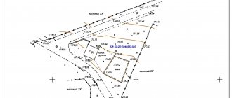
What is SPOSU and what does it include?
This document consists of 2 parts: graphic (actually, the diagram itself) and descriptive (more about it below). The following data must be indicated on the SPROM:
- The number of the GPZU issued to you.
- Plan of the house you intend to build.
- Capital structures already existing on the site. Please note: summer kitchens, greenhouses, sheds and even garages with bathhouses are not considered capital. objects - so, “temporary buildings”.
- Utilities laid along the site. If there are none yet, officials may become capricious and not issue a building permit. But this rarely happens, and the only way out of this situation is to file an application in court (or bribe, but this is more than unlawful and even criminal, don’t forget!).
- Passages and entrances to future and already built capitals. objects.
- If security, sanitary zones or zones of land easements run through the site (but this, in practice, does not apply to low-rise construction, but just in case), then their boundaries are indicated.
- Land area. By the way, if the courtyard is less than 1,200 m2, you can forget about the second floor.
- The area of all existing (and built in the near future) capital facilities on the site.
- Calculation of the development coefficient as a percentage (it is calculated as twice two: divide what you get in step 8 by the figure from step 7. And then multiply by 100).
- Type of fencing (mesh, wooden, reinforced concrete fence, etc.).
Scheme of planning organization of a land plot (SPOZU)
Order SPOZU: step-by-step instructions
A similar service is provided by both government agencies (architectural department of the local Administration) and commercial organizations. Specialists (engineers) work according to approximately the same algorithm, since they always ask to provide an urban planning plan, on the basis of which the SPOZU diagram is drawn up.
But in this case, the quality of work is practically guaranteed, and the price is quite affordable (the cost is given below). When choosing a contractor, you should pay attention to the company’s license, which gives it the right to engage in such activities.
Step 1. Collecting documents
Both individuals and companies fill out an application, but the specific list of documents differs. Individuals submit the following set:
- House project;
- certificate of ownership;
- urban planning plan;
- cadastral passport;
- results of topographic survey (terrain plan).
Companies also submit all these documents, but the following papers are added to them:
- detailed design specification;
- schemes for organizing the movement of pedestrians and vehicles;
- constituent documents (copies);
- architectural plans;
- engineering reports on survey results;
- description of the site, features of its location and intended use.
The application can usually be submitted online: to do this, use a form, upload a scan of the urban planning site, observing the requirements for image quality.
Step 2. Manufacturing procedure
As a rule, the production time takes 1 business day, so the finished diagram can be made on the day of your request. If the object is quite complex (in the case of legal entities), the period is set individually. The sheet with the drawing bears the seal of the organization, full name and position of the responsible specialist who compiled the diagram. The final document necessarily contains not only a drawing and a text part, but also a title page. In some cases, annexes are also drawn up.
Step 3. Payment for the service
As a rule, payment is made only upon completion of the service. In some cases, there are promotions with offers of 1900-2000 rubles for a typical site layout for individual housing construction. However, most often it varies in the range from 3,000 to 20,000 rubles:
- the average cost for work on sites in Moscow and the Moscow region is 5-10 thousand rubles;
- the price for the service in St. Petersburg and the Leningrad region is slightly lower: 4-8 thousand rubles;
- in regional and regional centers about 3-7 thousand rubles.
Thus, you can make your own OPSU diagram only if you have a certain skill in working in a special program and an understanding of the basic fundamentals of drawing.
It is important to understand that the contractor must not only be able to draw, but also correctly calculate all the parameters of the house in accordance with existing methods. If you are not sure, you should contact professional engineers.
Actually about the house
As you can see, so far we have taken into account both what has already been built on your land plot, and what (major) remains to be erected (in fact, the future house). And then we will only talk about the building for which all the paperwork and red tape was started fuss - capital family nest. So, in addition to the above, it is necessary to indicate the technical and economic indicators of the house, such as:
- area of attic and above-ground floors (the first is already above ground) (it should not be more than 1,500 m2).
- height of the building (for a private house - no more than 3);
- construction volume (not area(!)) of the underground and above-ground parts of the house (to do this, the area of all basement floors must be multiplied by their height. And do the same with the above-ground floors).
If there are already capital structures on the site, their technical and operational indicators are also indicated in the SPOZU (calculated in the same way as for a future house).
What documents are required?
When preparing the SPOSU, it is important to submit documents to the district administration at the location of the site.
To do this you will need the following:
- Copies of cadastral passports for buildings.
- Cadastral passport for land.
- Extract from the Unified State Register of Real Estate.
- Title document for the site.
- Urban planning plan.
- Topographical survey with display of boundaries.
- Statement of the established form.
The owner also provides a copy of the survey file and a sketch of the house, if available. Documents are submitted to the administration, after which a decision is made on compliance with current requirements.
Compound
The diagram includes two parts - text and graphic. Preparation of the text part includes:
characteristic features of the site;- justification for the planning organization of land;
- description of landscaping elements;
- description of the relief;
- technical and economic indicators;
- functional meaning;
- location of transport communications.
The graphical component includes the following:
- location of current buildings indicating approaches and entrances;
- buildings that are planned to be demolished;
- movement diagram of special equipment and vehicles at the construction site;
- plan of earth masses.
A situational plan is also indicated, which indicates the boundaries of populated areas. They are necessary if they are directly adjacent to the site. Areas with utility networks, transport interchanges, and special conditions of use are indicated.
Registration cost
Self-processing of documents does not require payment . There is no state duty. If you can independently prepare a site organization diagram and collect the necessary information, the application is submitted without additional payment.
If you contact a specialized organization, the average cost is 4-6 thousand rubles. The exact costs depend on the region where the site is located, the complexity of the project and individual characteristics.
Difficulties in preparation
When preparing on your own, it is important to avoid mistakes.
It is necessary to accurately and clearly plot the data on the diagram. Otherwise, a positive decision may be denied. It is important to make indentations from the roadway and neighboring areas and to correctly display the dimensions of the building to scale.
In addition, you can make a mistake with the height of the fence . The fence should not be too high. It should not shade the neighboring area.
To avoid disputes, it is advisable to install a fence no higher than 2 meters. You can also pre-agreed a higher fence with your neighbors, but in writing.
It is important to plan ahead for suitable building materials. If defects appear over time after the construction of the house, the work will have to be repeated. In this case, approval of a new scheme for the reconstruction of the facility will be required.
If it is difficult to cope with the task yourself, you can contact a specialized company . The document will be prepared within 1-2 days. All you have to do is provide the necessary documents.
Specialists will carry out the work in accordance with current rules and requirements. At the same time, wishes for the location and parameters of the future structure are clarified.
You can find out what documents are required to obtain a building permit here.