Land use and development rules (LRU) are an urban zoning document. From it you can understand whether it is possible to build on a particular site, what characteristics are allowed for the development object. Based on the PZZ data, the GPZU (Urban Planning Plan of the Land Plot) is obtained. GPZU is included in the mandatory list of documentation for design and approvals for the construction of new buildings and real estate reconstruction.
Calculator of the cost and timing of our services - here
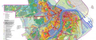
Read in the material what information the Land Use and Development Rules contain, how to correctly read and understand the designations of zoning maps, when and how changes to the land use zone are allowed.
What is a PZZ and how to understand the restrictions on the card
The official definition of PZZ is specified in Art. 1 of the Town Planning Code of the Russian Federation (). Land use and development rules are a document that defines territorial zones and regulations for land in a city or region. The content of the PZZ includes:
Dear Clients!
The information in this article contains general information, but each case is unique. You can get a free consultation from our engineers using one of our telephone numbers - call:
8 Moscow (our address)
8 St. Petersburg (our address)
All consultations are free.
- descriptive part - the procedure for applying the PZZ and obtaining information, the algorithm for making adjustments;
- zoning maps - they determine what can be built in certain areas;
- urban planning regulations - they determine the legal status of the site, permitted types of use, maximum dimensions for the location of objects on the site, permissible parameters of buildings.
Based on the PZZ, extracts and GPZU are issued for plots and zones, and the territory development project is approved. The document is accepted by regional or municipal authorities, undergoes public hearings, and is published in the public domain.
To independently study the PZZ and find out what restrictions have been introduced for the site, you need to know the basic definitions. They are indicated in the General Part of the PZZ. For example, in the capital, PZZs were approved by Resolution No. 120-PP (). Designations and restrictions on zoning maps have been removed as follows:
- to determine the status of a site and construction restrictions, alphabetic and numerical designations are used (for example, the index “F” provides for a zone of preserved land use, and “N” - zones for which no regulations have been established);
- Numerical codes are used to identify the type of permitted use and construction (for example, for shops with an area of up to 5000 sq.m., code 4.4.0 is used, and for hostels, code 4.7.1);
- To indicate zones whose regulations were in force at the time of approval of the PZZ, the color red is used.
Thus, knowing the combination of letters and numbers, you can first assess the legal status of the land and possible development options. Official information will be contained in an extract from the PZZ, which can be obtained from the administration.
Expert commentary . The validity period of the GPZU is 3 years. Making changes after receiving the GPZU is extremely difficult or even impossible. Therefore, obtaining the GPZU can be postponed if the developer (customer) needs to undergo amendments to the PPZ. Therefore, before designing, you can conduct a preliminary analysis of the PZZ and go through the procedure for changes. Our company provides such services.
Calculator of the cost and timing of our services - here
The Land Use and Development Rules indicate zones of permitted use and symbols for the construction of facilities
Submitting an application
Having collected the necessary documentation, you can take all the papers and proceed to the first stage of the procedure - submitting an application for the preparation of a land surveying project. It is written in any format on a regular sheet of paper or on forms developed by the local administration. It is important to indicate in the application:
- Applicant information.
- Briefly describe what land plot you are talking about.
- Justify the need to prepare a PMT.
- Express a request to review the submitted package of documents.
- List all documents attached to the form.
The paper is signed by the applicant, after which the date of submission of the form for consideration is indicated on it. The application is drawn up in the name of the head of the local administration or another person is indicated who is responsible for receiving such applications and making a decision on them. It is submitted to the municipal department of architecture and urban planning.
An application may be rejected immediately upon initial consideration for two reasons:
- Incorrectly composed text.
- Incomplete list of attached documents.
If this does not happen or the applicant has eliminated the shortcomings, then the receiving specialist is obliged to register the application and notify the person about the time for consideration of the above.
An application may also be rejected at the consideration stage. Refusals are always justified, which allows the applicant to clearly understand the reasons for such a decision and develop a plan for further action or refuse to carry out work altogether.
How to get GPZU
Obtaining the GPZU is carried out at the initial stage of research and design. The urban planning plan of the land plot can be obtained through the State Services portal, or through the mos.ru website using the link. The document is issued by MosKomArchitecture. When submitting an application, you must attach title documents to the site, as well as to the objects located on it (if information about them is not available in the Unified State Register of Real Estate).
An extract from the PZZ is generated free of charge within 14 days after submitting the application. The document is issued only in electronic form. After receipt, the GPZU must be submitted along with the project for examination to obtain permission from the State Construction Supervision Authority.
An urban planning plan for a land plot is issued in the form approved by Order of the Ministry of Construction of the Russian Federation No. 741/pr (). The document will contain the following information:
- GPZU number (assigned upon issuance);
- the basis for issuing the document (for example, details of the application from the copyright holder);
- location and description of the boundaries of the site (this data is filled out in accordance with the Unified State Register of Real Estate);
- area, cadastral number;
- information about objects already located on the ground;
- information about the boundaries within which a new facility can be built (for this, an urban zoning map, a territory development project, and USRN information are used);
- information about the planning or land surveying project;
- GPZU drawings.
The listed points are a general part of the GPZU. For design purposes, the most important data will be indicated in section 2 of the GPZU.
Amendments to land use and development rules. Questions to the expert.
Soloviev Petr
Expert in the field of certification, cadastre, real estate and design. Higher legal education, more than 10 years of work experience.
Ask a Question
Question to the expert
Where should I go to make changes to the PZZ?
In Moscow, issues related to changes in Land Use and Development Rules are considered by MosKomArchitecture.
Good afternoon It is imperative to request a GPZU. to make changes to the PZZ?
Yes, it is necessary, since the GPZU is included in the mandatory set of documents for changing the PZZ.
How many times can changes be made to the PZZ for one site?
The number of changes is not limited, however, when re-applying, you cannot use the simplified version (except for increasing the area by 10%).
The extract from the PZZ will contain:
- information about the regulations (if they are approved for the site);
- main, auxiliary and conditionally permitted types of land use (for example, for residential development, agricultural land);
- maximum dimensions of the plot, area;
- minimum permissible setbacks from the boundaries for the object under construction;
- the maximum permissible height and number of storeys of the building;
- maximum percentage of development within the boundaries of the site;
- requirements for architectural solutions (established for historical development zones).
A separate table is filled out according to the parameters of permitted construction, if regulations have not been approved for the site, or during development it is necessary to comply with the restrictions of environmental zones.
Section 4 of the GPZU specifies requirements for the provision of engineering, social and transport infrastructure. Sections 5-6 describe restrictions for areas where there are zones with special conditions of use. Section 9 of the GPZU will indicate the technical specifications for connecting the facility to the engineering infrastructure.
Expert commentary. To prepare the GPZU, an urban zoning map and a territory development project are used. These documents are developed simultaneously with the PZZ and are included in their composition. It is prohibited to build an object if its type and permitted use do not correspond to the specified documents. The same problems will arise during reconstruction if the design decisions involve exceeding the maximum permissible area, height, number of floors, and setbacks. For this reason, the main way to bypass or eliminate restrictions is to make changes to the PPL.
The GPZU indicates information from the Land Use Rules in relation to a specific site
Composition of the territory surveying project
The territory surveying project is presented in several parts:
- the main one, which is subsequently subject to approval;
- and materials justifying the feasibility of the desired project.
The land surveying project is presented, in essence, by a drawing, which reflects a number of the most important elements of the future site, namely:
- red lines (borders), already approved during the design, or changed during land surveying;
- the indentation from the red lines, which determines the presence of places in which buildings, various structures and structures can subsequently be placed;
- the boundaries of land plots that are present on the cadastral project, as well as the numbers assigned to each of the formed territories;
- boundaries framing the territories in which objects included in the cultural heritage list are located;
- territories within which special rules of use apply;
- areas of public easements.
A territory surveying project is specialized documentation designed to help specialists carefully consider what changes this or that land area will subsequently undergo.
In addition, the required document must indicate:
- areas of plots or parts thereof subject to change;
- land plots formed for the first time, which will subsequently become objects subject to general use;
- type of use of the plots.
There are clear requirements regarding the content of the survey project
10 percent rule for increasing area in GPZU - a new simplified procedure
Amendments to the general plan of the site are permitted in a simplified manner. The grounds for this are indicated in paragraph 3.3 of Art. 33 Civil Code of the Russian Federation:
- if, as a result of the application of the PZZ, harm is caused to copyright holders, the value of the land of the objects is reduced;
- if a one-time change of type of use is necessary (without changing the permissible parameters of the object);
- if you need to change the type of use with a one-time change in the parameters of permissible construction, but not more than 10% compared to the site regulations.
The last point is especially important, since it can be used in the interests of developers and during reconstruction with an extension or superstructure.
Making changes to the general plan in a simplified manner allows you to do without holding hearings or passing the City Commission. For example, in this way you can immediately contact MosKomArchitecture to increase the building area. All procedures will go much faster. If you need to make changes to the master plan in a simplified manner, our specialists will provide assistance in preparing documents.
By the designations on the PZZ maps you can understand with what permitted types of activities the facility can be built
Administration decision
After receiving the application, it will be considered in accordance with the procedure established by law. When assessing the stated request, not only those forms that were collected and provided by the applicant himself are used, but also papers that are available to specialists of the architectural department. The administration faces a difficult task:
- Study the documents provided and those at their disposal, comparing the data and confirming their unity. The presence of contradictory aspects will not allow you to proceed to the next stage.
- Analyze whether it is possible to implement the stated request, taking into account the construction projects already existing there and the communications laid.
- Assess the prospects of development, or make proposals for transferring the planned work to another plot of land.
The result of the analysis is a decision on the possibility of preparing a project for surveying the specified territory or on its refusal. If the issue is resolved positively, then the department’s specialists prepare a plan for its implementation.
The procedure for preparing documents for amending the PZZ
Amendments to the 2021 PZZ in Moscow are carried out according to Resolution No. 457-PP (). The proposal and all documents are sent to MosKomArchitecture in electronic format via the website mos.ru. The set of documents includes:
Calculator of the cost and timing of our services - here
- an explanatory note where you need to describe the planned use of the site;
- situational plan, displaying the zone for which changes to the general plan are required (existing objects are indicated on the plan);
- development diagram showing the location, economic and technical parameters of future buildings;
- estimated standards for the provision and accessibility of utility, transport, and social infrastructure;
- a copy of the GPZU with source data.
The owner of the site can prepare the documentation himself or entrust it to professionals. Our company will ensure the preparation of documents in strict accordance with the Moscow Law and Regulations, the Civil Code of the Russian Federation and Resolution No. 457-PP, and will help you quickly go through the mandatory stages of their consideration.
Coordination
The penultimate stage is the approval of the drafted project. This step is very important, since it affects the interests of not only the local administration, but also private individuals, as well as legal organizations. Coordination implies the formation of a special commission that will consider all the documents provided, as well as the results of the topographic survey, and render its verdict.
Approval can take place in one stage in the form of public hearings, but in some cases a secondary procedure is required. This procedure is needed in cases where we are talking about designing a territory that is common shared property. With such ownership, one cannot do without the participation of shareholders, who must also express their opinion on the prepared PMT. Shareholders are allowed to vote after public hearings, taking into account all the adjustments made.
At the last stage of the PMT, utility services are agreed upon, which will subsequently provide their services to the developed properties.
Example and example of making changes according to the new rules
We invite you to familiarize yourself with examples of the main documents that are necessary for changes to the 2021 PPL.
Sample 1. To change the Land Use Rules, you need to submit a situational plan of the site.
Sample 2. To change the PZZ, you need to prepare and submit a diagram of the future development.
Public hearings
The work of specialists must be checked by experts at different levels, because a land surveying project cannot have unaccounted aspects. It is for this purpose that public hearings are scheduled. Their goal is to identify shortcomings in PMT and jointly eliminate them. To conduct hearings, an extract from the General Plan must be prepared, which indicates all existing buildings on the specified territory. The commission must take into account the following factors:
- Natural.
- Technogenic.
- Seismic activity in the region.
PMT can be adopted in the following variations:
- Unconditionally approved.
- Agreed with comments and amendments.
- Rejected.
If errors are identified, all comments and explanations thereto are recorded in the minutes of the hearing. At the same time, the project itself will first require adjustments, and only then re-approval. The initiator of this procedure will again be required to submit an application for the development of a PMT and attach to it the conclusions made by the commission members.
The commission also gives reasons for a negative decision and notifies the applicant in writing of the reasons for the refusal. It is usually accompanied by expert opinions and conclusions.
The cost and price of making changes to the PZZ
The period for consideration of initiatives to change the PPL is up to 60 days, of which 30 days are spent on consideration of documents by the commission. Under the simplified procedure, after the expiration of the specified period, a regulatory act will be issued to make adjustments to the Rules. The review procedure itself does not involve payment of fees and charges. The developer's costs will include collecting and preparing documentation for which the proposal is being submitted. The cost of such services depends on the basis for the changes, the type and characteristics of the site, and future objects. You can clarify the prices of the MSR Architectural Bureau during a free consultation by phone.
Time frame for developing a land surveying project
If the project under consideration is prepared in the form of paper separate from the rest of the package, then the time frame for its development will vary depending on such an indicator as the size of the area being worked on. Accordingly, the larger it is, the longer it will take to process it. On average, this period is 2-4 months.
The timing of the development of a land surveying project depends on the area of the object
Example
Let's consider the land surveying scheme for the block bounded by Balaklavsky Prospekt, Azovskaya Street, Chernomorsky and Simferopolsky boulevards in the Moscow Zyuzino district. The sample is published on the website of the prefecture of the South-Western District of Moscow at https://yadi.sk/i/iaVJpd48h9RNe.
The project was developed by JSC Mosproekt-2 named after. Posokhin" in 2014. The customer is the Moscow City Property Department.
Justification materials include BTI data on buildings located within the block, ISOGD data on the areas of various restrictions, and field research data on actual land use. The calculation of the required area of adjacent areas was carried out taking into account the standards that existed at the time when the quarter was built up, that is, from 1959 to the present day.
70 plots have been formed, including local areas of 28 residential buildings. For six buildings (three of which are newly built 24-story towers), the adjacent areas turned out to be less than the regulatory required area.
For all houses, in addition to the standard land plots, plots “with minimal encumbrance” are allocated. This practice, introduced by the Moscow government contrary to federal legislation, is aimed at enabling residents (if they wish) to abandon regulatory sites and thereby save on taxes.
17 plots are allocated for public use. These are courtyard driveways, pedestrian paths, parking lots and playgrounds, as well as the roadway and sidewalks of Starobalaklavskaya Street, which does not have the status of an element of the road network.
Statement
The direct customer of the plan or persons who own the plot on the basis of shared ownership must approve the boundary plan before it can be used to obtain ownership rights or as a basis for the sale of the plot, donation, lease or other civil law contracts.
Who approves?
Approval of the drawn up document can be carried out by the following persons :
- Directly by the owner of the plot, who acted as the customer for the land survey;
- General meeting of persons who are in shared ownership.
In the event that the approval will be carried out by one owner alone, then he simply puts his signature as a sign of agreement with the executed plan, but if there are several owners (with shared participation), then in such a situation the approval of the project is recorded by drawing up an approval protocol .
Contents of the protocol
If the project is approved by the share owners, the cadastral engineer must draw up a separate protocol, which is subsequently attached to the drawn up boundary plan.
Such a document contains the following data :
- Indication of the full names of persons, each of whom has a certain share of the land plot;
- Signatures of those who fully agree with the drawn up boundary plan;
- Data that the list of owners was separately approved;
- Information about which shares will belong to the meeting participants.