Before starting construction work, it is necessary to determine the location of buildings and communications, and correctly direct traffic flows. For this purpose, a concept for the development of the territory or a general development plan is being developed, as part of the project documentation it is called “Scheme of the planning organization of the land plot”, the presence of this section of the project documentation is mandatory and is regulated by Decree of the Government of the Russian Federation No. 87 of February 16, 2008 “On the composition of project documentation” .
Why do you need a general site plan?
The scheme is actually a map of future development. When developing a master plan for your site, our master planners take into account:
- relief features and surrounding buildings;
- the possibility of access roads and transport links;
- what facilities will be built in a specific area;
- what communications will be connected to the objects, how to ensure their correct connection (sewage, gas, electricity, water);
- what work needs to be done to bring the scheme to life.
The document will provide information not only about the capital construction project, but also about the landscaping work (in particular, about green spaces, the location of sidewalks, and street lighting). The plan takes into account fire and sanitary safety requirements. Facilities will be located at a safe distance from each other to prevent the spread of fire and protect the health of people living or working in a certain area.
Development of a territory planning project and its approval
The purpose of preparing the PPT is to highlight the elements of the planning structure and establish the parameters for their development.
The development of PPT is carried out on the instructions of the competent authorities, as well as by decision of private individuals - in cases established by law (clauses 1–1.2 of Article 45 of the Civil Code of the Russian Federation), for example, legal holders of land plots when they carry out complex development of the territory, etc.
The initial data for the development of PPT are:
- decision of the local self-government body on the development of such a PPP;
- architectural and planning task;
- technical specifications for design, etc.
Preparation of PPT is carried out in accordance with legislative acts and regulatory and technical documents of the Russian Federation and constituent entities of the Russian Federation in the field of urban planning.
The approval of the territory planning project is carried out by the competent authorities of the federal or municipal level (for example, the approval of the PPT prepared in relation to the territories of historical settlements of federal significance is carried out by the Ministry of Culture of Russia, see regulation ..., approved by order of the Ministry of Culture of Russia dated July 31, 2013 No. 1062), only after this, the documentation is submitted for approval of the territory planning project (Article 45 of the Civil Code of the Russian Federation).
Components of the master plan
The master plan of the land plot includes a number of subsections:
- Scheme of the planning organization of the land plot showing:
— locations of existing and projected capital construction projects, indicating existing and projected entrances and approaches to them;
— existing buildings and structures of capital and non-capital construction;
— decisions on planning, landscaping, landscaping and lighting of the territory;
— stages of construction of a capital construction project;
— traffic patterns for vehicles on the construction site;
— a diagram of utilities to which the facility will be connected after completion of construction work.
- Earth mass plan - includes measures to carry out the minimum volume of earthworks during the construction of structures, buildings, as well as roads.
- Utility network master plan.
It indicates the connection points of the planned capital construction facility to existing utility networks. This plan also includes a lighting scheme (internal, indoors, as well as external, street);
- Situational plan for the placement of a capital construction project.
It indicates the boundaries of the land plot and the boundaries of settlements directly adjacent to the boundaries of the specified land plot, the boundaries of zones with special conditions for their use
- Explanatory note - indicates significant points in the implementation of the project, the technologies used, and the sequence of work carried out.
Urban planning documentation
Master plan Type of work: Development and amendments to master plans of settlements and urban districts
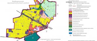
A master plan is a document that defines the layout and development of the territories of a district or settlement, the boundaries of functional zones, the location of the planned location of transport and engineering infrastructure, energy, industrial and agro-industrial complex, taking into account existing natural and man-made restrictions. The master plan of a district or settlement is developed for the territory of a municipal entity, but it is possible to prepare it for individual settlements that are part of the settlement or district, with subsequent introduction of changes relating to other parts of the territory of the settlement or urban district. This document reflects both planned objects of local importance, decisions on the location of which are made by local government bodies of the urban district / settlement, and planned objects whose location is determined by territorial planning documents of higher levels. The master plan determines the strategic direction of development of a settlement or district for a period of 20-25 years, therefore decisions during development must be verified, balanced, and they must be made taking into account a comprehensive analysis of all factors. The master plan is the basis for changing the boundaries of settlements, as well as the basis for the development of documentation for the planning of the territory.
Rules for land use and development Type of work: Development and introduction of amendments to the rules for land use and development of settlements and urban districts Rules for land use and development - a document of urban planning zoning, approved by regulatory legal acts of local governments, extending its effect to a municipality or part of it, which establishes boundaries of territorial zones, boundaries of zones with special conditions for the use of the territory, urban planning regulations on them, as well as the procedure for applying this document and the procedure for making changes to it.
Territory planning project Type of work: Development of territory planning projects for existing and under construction linear and areal objects
A territory planning project is a document, the development of which is carried out to highlight the elements of the planning structure, establish the parameters of the planned development of the elements of the planning structure, the zones of the planned placement of capital construction objects, including objects of federal significance, objects of regional significance, and local objects. The territory planning project is the basis for the development of territory surveying projects. A territory planning project is developed for the territory of a block, microdistrict or other territories called “elements of a planning structure” in urban planning legislation. PPT contains the main indicators necessary to determine the investment attractiveness of the territory - population and possible volumes of new construction (housing, business, social, cultural, transport, engineering). The decision to prepare a PPT is made by the head of the local government body of a settlement or local government body of a city district, the PPT is approved by a state or municipal authority in compliance with the public hearing procedure in accordance with Article 46 of the Town Planning Code of the Russian Federation. The drawing developed as part of the PPT is the basis for subsequent types of design work, in particular for the development of territory surveying projects. PPT is the basis for the formation of urban planning plans for land plots necessary to obtain a construction permit, and the documentation for the linear object itself will be the basis for obtaining a construction permit. The concept of “PPT” differs from the concept of “master plan”. Unlike the master plan, which is a document with enlarged indicative indicators, the PPT is a more detailed document of urban planning regulation, containing red lines, facilities and infrastructure. The master plan of the settlement, unlike the PPT, does not contain the necessary data to assess the feasibility of construction. Based on the approved PPT, an urban planning plan for the land plot (GPZU) is issued. GPZU is necessary to obtain a building permit.
Territory surveying project Type of work: Development of territory surveying projects for existing and under construction linear and areal objects. A territory surveying project is being developed in order to determine the location of the boundaries of the land plots being formed and being changed. Preparation of the project is regulated by Article 43 of the Town Planning Code of the Russian Federation dated December 29, 2004 N 190-FZ (as amended on December 31, 2014). A territory surveying project is necessary in the following cases provided for by the Land Code (clause 3 of Article 11.3 of the Land Code of the Russian Federation): when forming land plots from a land plot provided for the comprehensive development of the territory; when forming land plots from a land plot provided to a non-profit organization created by citizens for gardening, vegetable gardening, dacha farming or for running dacha farming to other legal entities; when creating land plots within the boundaries of the territory in respect of which, in accordance with the legislation on urban planning activities, an agreement on its development has been concluded; when creating land plots within the boundaries of an element of the planning structure built up with apartment buildings; when creating land plots for the placement of linear objects of federal, regional or local significance. The Town Planning Code also provides for cases of preparing a land surveying project as a separate document. In relation to the territory within the boundaries of which activities for the integrated and sustainable development of the territory are not envisaged, and the placement of linear objects is not planned, it is allowed to prepare a land surveying project without preparing a territory planning project for the purposes provided for in Part 2 of Article 43 Grad. code. (Clause 5 of Article 41 of the City Code), such goals are: determining the location of the boundaries of the land plots being formed and changed; establishing, changing, canceling red lines for built-up areas within the boundaries of which it is not planned to place new capital construction projects, as well as for establishing, changing, canceling red lines in connection with the formation and (or) change of a land plot located within the boundaries of the territory, in relation to which does not provide for the implementation of activities for the integrated and sustainable development of the territory, provided that such establishment, amendment, or cancellation entail exclusively a change in the boundaries of the public territory.
The institution provides the following paid services:
- Preparation of a territory planning project and/or territory surveying projects , including the implementation of certain types (parts) of work for the purpose (within the framework) of preparing documents on territory planning
- Preparation of a draft master plan or a draft amendment to the master plan of a settlement , individual settlements included in the settlement, including the implementation of certain types (parts) of work for the purpose (as part of) the preparation of territorial planning documents
- Preparation of a draft master plan or a draft amendment to the master plan of an urban district , individual settlements included in the urban district, including the implementation of certain types (parts) of work for the purpose (as part of) the preparation of territorial planning documents
- Preparation of a draft scheme or a draft amendment to the territorial planning scheme of a municipal district , including the implementation of certain types (parts) of work for the purpose (within) the preparation of draft territorial planning documents
- Preparation of a draft land use and development rules or a project to amend the land use and development rules of a settlement, urban district, individual settlements included in a settlement or urban district, including the implementation of certain types (parts) of work for the purpose (within the framework of) preparation of the project rules (draft amendments to the rules) of land use and development
- Preparation of project documentation , including the preparation of special sections of project documentation, preparation of diagrams, plans, information, projects, architectural/constructive/technological solutions, as well as work on organizing the preparation of project documentation
- Preparation of materials submitted by applicants to the Commission on Land Use and Development of the Nizhny Novgorod Region when considering issues on: - introducing changes to the master plan; — introducing changes to the rules of land use and development; — granting permission to deviate from the maximum parameters of permitted construction, reconstruction of capital construction projects (with the exception of individual housing construction projects, garden houses); — granting permission for a conditionally permitted type of use of a land plot or capital construction project (with the exception of individual housing construction projects, garden houses).
Submit an online application for paid services
Phone number for inquiries ext. 260, 261 (STP, GP, PZZ) and 265 (PPM)
How to order a master plan for a land plot or a territory development concept?
To order a general plan, it is enough to leave a request on the website, indicating a list of objects and territories where construction work is planned. The INFOSTROY-mosreg company will undertake to develop a master plan for the land plot with a development concept, taking into account all legal requirements. The document will help:
- Decide on the location of objects on the site;
- The master plan or development concept can be used as presentation material in city planning departments and at public hearings;
- The developed master plan will be a ready-made section of the design documentation for obtaining a construction permit.
The master plan of the land plot is issued to the client both electronically in PDF format and in the form of a paper album.
| Calculate the cost of the service | Order service |
Why is PMT needed?
The Land Code of the Russian Federation (Article 11.3) provides for five cases that require the development of a territory surveying project:
- from one large plot of land it is necessary to allocate a smaller plot for subsequent development and construction;
- it is necessary to allocate a plot of land from the territory that the municipal authority has provided to a dacha, garden partnership or other non-profit organization created by citizens. Most often we are talking about the allocation of SNT land to individual users;
- A development agreement was drawn up for the territory. Such a document is concluded on the basis of town planning legislation and provides for the division of a large plot into several separate ones;
- it is necessary to allocate a site in an area with multi-storey buildings;
- it is planned to build roads, pipelines, power lines and other linear facilities.
It is important to take into account that a territory surveying project is a document that affects not only municipal authorities, large landowners and developers. It also applies to ordinary land owners. Without the development of a project and, accordingly, established boundaries, a land plot cannot be registered, put on the cadastral register, bought, sold or donated