A new law has come into force in Russia, which allows ordinary citizens to order complex cadastral works. The regulatory act came into force on March 23, 2021. Previously, only government authorities could use such services. How the new rules will work and how they can make life easier for owners of houses and land, read in our material.
What is cadastral work?
Each property has its own individual characteristics: boundaries , area, height, etc. To register a house or divide one plot of land into two, you need to take into account all the characteristics and enter them into the Unified State Register. To do this, a cadastral engineer comes to the site and carries out cadastral work. He clarifies the actual boundaries and other characteristics, and then draws up a boundary plan and the property is registered in the cadastral register.
This is necessary in order to register the right to own a plot or cottage. So that in the future a person can use and dispose of the property: sell, give, inherit, etc.
After registration, the cadastral value of the property is determined. It depends on the area of the land plot, as well as on the category of land and the type of permitted use. For example, land in populated areas intended for individual housing construction will cost more than plots for gardening on agricultural lands. And the higher the cadastral value, the higher the property tax and the more expensive the property can be valued upon sale.
In addition, cadastral work is carried out in order to correct errors in determining boundaries or resolve a land dispute between neighbors.
Complex cadastral work is the simultaneous registration of several plots at once that are located on the territory of one cadastral quarter: a dacha or garden partnership, or a cottage community.
Land management works
Land management activities are understood as a set of actions performed by government agencies together with geodetic services to study land plots and changes on them. This information is used as the basis for surveying areas with the installation of signs, as well as planning the method of exploitation of the territories.
This service is ordered when measuring the boundaries of administrative units and allocating land for agriculture and construction, conservation of unusable areas. Research includes:
- collecting data on the current state of land;
- description of the exact location of the borders, actual compliance of the parameters with the entries in the Unified State Register of Real Estate - all papers are drawn up in accordance with regulations;
- geodetic research, cartographic work, which involves collecting information on the territory being inspected by taking measurements of land ownership, determining heights and coordinates, and monitoring changes on it;
- calculating the boundaries of the site with the installation and fixation of signs, entering parameters into the established land management documents;
- planning the rationality of further exploitation of the land is necessary to assign it a designated purpose in accordance with approved development projects for the district and the country as a whole;
- on-farm development of land plots in remote areas used for agriculture without changing the traditional way of life of local residents.
The purpose of land management work is to bring land operations into the required order, expedient use for the benefit of the development of the state, as well as the protection of land resources. When degraded areas are discovered, measures are developed to restore their properties.
What is the essence of the new law?
Until the end of March, complex cadastral work could only be carried out at the request of the local administration or regional authorities using budget money. For example, during the construction of a new microdistrict or when laying a new road. And if there was no money in the treasury, then such work was not envisaged. Therefore, ordinary citizens had no chance to carry out land cadastral work for free.
In order to register a built house or demarcate a plot, the owners had to call a cadastral engineer themselves and spend a lot of money on it.
The new law allowed complex cadastral work to be ordered by private individuals. Summer residents or residents of cottage villages can, without waiting for a decision from the authorities, unite and carry out large-scale cadastral work at their own expense immediately.
The authors of the bill see some advantages in the innovation:
- Saving . The new regulation should reduce the cost of cadastral engineer services. When carrying out complex work, the cost of one site will be approximately 1,300 rubles. Calling a specialist individually now costs ten times more.
- Less mistakes . When carrying out complex cadastral work, cadastral engineers will determine the boundaries of all plots at once, so the likelihood that there will be errors or inaccuracies should be reduced.
- The new law will correct existing errors in documents. And adjust the size of the plot to 10% of the figure indicated in the papers. If the actual data does not match the documents.
- Reducing land disputes. If there are no errors in determining the boundaries of land plots, neighbors will have fewer reasons for disputes.
How much does land surveying cost?
Cadastral work is carried out by a cadastral engineer on the basis of a contract for cadastral work. The cost of work is determined by the parties to the contract based on the estimate.
The price of land surveying depends on many factors. It can vary both due to the prices of the organization itself that carries out the work, and from the specific site - its features, configuration, location, size and type of work (formation of a new site, division, redistribution of land).
How to carry out complex cadastral work?
- Step 1. Send a request to the administration
Check to see if the authorities plan to carry out comprehensive cadastral work for free. To do this, you should send a request to local authorities and wait for a response.
- Step 2. Team up with like-minded people
If officials are in no hurry with large-scale registration, then owners of land plots or houses can unite and raise the necessary amount of money to order complex cadastral work.
- Step 3. Choose a representative
To do this, you need to hold a meeting and select one representative, who must find a cadastral engineer and enter into an agreement with him to carry out complex cadastral work throughout the entire territory.
- Step 4. Registration
After carrying out the work, cadastral engineers draw up a plan map and send the document for registration of rights to the Unified State Register of Real Estate.
- Step 5. Check for registration
This can be done by looking at the cadastral map. If the object is registered, you can easily find the necessary information: cadastral number, area, cadastral value. If you want to get more extensive information, for example, check for encumbrances and restrictions, look at the history of the owners, then you should order an extract from the Unified State Register of Real Estate . This document will give a complete picture of the property. You can get it quickly and easily using the EGRN.Reestr service. Indicate the cadastral number of the house or plot or its address. During the day, a report with up-to-date and reliable data will be sent to your email.
Text: Ksenia Chertova
What is all this for?
Cadastral and land management work is carried out only by specialized licensed companies. In combination with engineering surveys, they make it possible to obtain all the necessary data for the construction, reconstruction and major repairs of buildings, the consolidation and breakdown of land plots, and the change of their intended purpose.
Professional engineers carry out all necessary procedures in strict accordance with current regulations and legal requirements. The completion time depends on the volume of research, complexity of implementation and tasks to be solved.
It should be remembered that registration documents for real estate and land are issued only after cadastral activities have been carried out. Transactions with land and buildings without the availability of appropriate, correctly executed materials, according to the legislation of the Russian Federation, are considered invalid.
Did you find this article helpful? Please share it on social networks: Don't forget to bookmark the Nedvio website. We talk about construction, renovation, and country real estate in an interesting, useful and understandable way.
How to draw up a land survey plan for a multi-circuit area
Multi-circuit plots have a complex configuration: they consist of several circuits or have “holes” - for example, a land plot of two parts that are separated by a road, or a plot on which a power transmission tower is installed.
For such areas, a single boundary plan is drawn up, which describes all the individual parts of the site, and the multi-circuit area itself receives a single cadastral number.
When surveying multi-circuit areas, difficulties may arise. For example, the site may be long, which will complicate geodetic measurements. Or, due to the fragmentation of the site, there may be common boundaries, for example, with six neighbors - such a number of participants will complicate coordination. All this will affect the cost of surveying and the timing of work.
REAL ESTATE CADASTRE AND MONITORING OF NATURAL RESOURCES
UDC 332.77:528.44Musina E. F., student, Tairova G. K., student
Scientific supervisor: Ishbulatov M. G., Candidate of Agricultural Sciences, Associate Professor
Bashkir State Agrarian University, Russia
Methods for dividing land plots are considered. An example of the division of a land plot with cadastral number 02:47:060205:239 is given
Translated from Latin, “cadastre” means an inventory of taxable items or a book that contains an inventory of taxable lands indicating their area, soil quality, and the amount of land tax. It follows from this that the land cadastre has an interconnected, unified system of signs and characteristics, which are combined into sections, each of which carries specific and necessary information. At the first stage of reform in Russia, the land cadastre was created to develop a unified system of accounting and registration of real estate (land plots, capital construction projects). The basic unit of the land cadastre is the land plot. A land plot is a part of the earth’s surface that has boundaries fixed on the ground. To determine the location of the coordinates of characteristic border points, cadastral work is carried out, which is carried out during the division, merger, redistribution, clarification of land plots.
In the history of land registration in Russia, four main periods can be distinguished:
- 1960-1990 Attention was paid to agricultural lands, redistribution of land plots, assistance in developing production forces and maintaining land fertility. The land registration process was managed by the Ministry of Agriculture;
- 1992-2001 Cadastral registration authorities were involved in supporting the process of transfer of land from state to private ownership, that is, they carried out the tasks of simultaneous registration with the state cadastral register and registration of the right to a property;
- 2001-2008 Two accounting systems were maintained: for land plots - this is the state land cadastre, for capital construction projects - this is the technical inventory bureau;
- 2008 to present vr. A unified system of registration of rights and state cadastral registration is being developed - the Unified State Register of Real Estate (USRN).
Let us consider cadastral work in connection with the formation of land plots by dividing a land plot.
According to the Land Code of the Russian Federation dated October 25, 2001 N 136-FZ (as amended on August 2, 2019, Chapter I. 1 Article 11.2) Land plots are formed during the division, merger, redistribution of land plots or allocation from land plots, as well as from lands which are in state or municipal ownership.
In St. 11.4 of the Land Code of the Russian Federation states that when a land plot is divided, its owner acquires the right of ownership to all land plots formed as a result of the division.
When dividing a land plot that is in common ownership, shareholders of common property retain the right of common ownership to all land plots formed as a result of such division, unless otherwise established by agreement between the parties.
There are 2 ways to divide a land plot that is in common shared ownership:
- Voluntarily, by signing an agreement on the allocation of land in kind.
A voluntary agreement is concluded between all land owners if they all agree to the division. The document is drawn up in free form, which indicates: personal data of all signatories of the agreement; address of the land plot to be divided; cadastral number of the original land plot; confirmation that all parties agree to the division; place and date of signing the agreement.
When voluntarily allocating a share and actually dividing the land, the following action plan must be followed:
- land surveying. In the process of this land surveying, new, formed plots are immediately registered in the cadastral register.
- preparation of a plan for the allocated area and an act of approval of its boundaries.
-submission of documents to the local municipality for approval of the plan.
- registration of permission for the actual division in local governments.
-submitting documents to Rosreestr and obtaining a certificate of ownership of the allocated land plot (extract from the unified state register of real estate).
An example of the division of a land plot that is in shared ownership.
The land plot with cadastral number 02:47:060205:239 is located at the address: Republic of Bashkortostan, Ufa district, village Zubovsky, Zubovo, Aurora street, 17. According to information from the Unified State Register of Real Estate dated December 5, 2019 No. 99/2019/299302039 the land plot was registered in the cadastral register on July 30, 2009 with an area of 1534+/- 14 sq.m. (Fig. 1) with a mean square error of coordinates of characteristic points of the boundaries of the land plot - 0.1 m (Fig. 2). On the land plot there is a blocked building with cadastral numbers 02:47:060205:979 (Block 1), 02:47:060205:978 (Block 2).
Rice. 1 — Information about the characteristics of the property
Rice. 2 - Information about characteristic points of the border of the land plot
Land category: lands of settlements. Type of permitted use: residential block of a blocked building (consisting of 2 blocks) on a separate plot of land. (Fig. 3).
Rice. 3 - Information about the characteristics of the property
The land plot is in shared ownership between L.G. Goryunova (Shared ownership, No. 02-04-01/327/2013-768 dated 09/16/2013, 1/2) and N.S. Tokunova (Shared ownership, No. 02- 04-01/120/2014-512 dated 04/03/2014, 1/2) (Fig. 4).
Rice. 4 - Information about registered rights
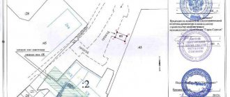
The boundary plan for the formation of 2 land plots by dividing a land plot with cadastral number 02:47:060205:239 was carried out on the basis of the cadastral plan of the territory, an extract from the Unified State Register of Real Estate, Land Use and Development Rules of the joint venture Zubovsky village council of the MR Ufa district of the Republic of Belarus (as amended by the Decision of the Council of the joint venture Zubovsky s/s MR Ufa district of the Republic of Belarus No. 109 dated 05/17/2016), extracts from the town planning regulations of the joint venture Zubovsky village council No. 835 dated 02/04/2019, extracts from the town planning regulations of the joint venture Zubovsky village council No. 836 dated 02/04/2019.
The land plot was divided analytically into: ZU1 with an area of 753 sq.m. and on: ZU2 with an area of 754 sq.m. The type of permitted use was assigned on the basis of the Land Use and Development Rules of the joint venture Zubovsky village council of the MR Ufa district of the Republic of Belarus - a residential block of blocked development (consisting of 2 blocks) on a separate land plot. On the newly formed land plot with the conditional number 02:47:060205:239:ZU1 there is a capital construction facility with cadastral number 02:47:060205:979. On the newly formed land plot with the conditional number 02:47:060205:239:ЗУ2 there is a capital construction object with the cadastral number 02:47:060205:978 (Fig. 5). The resulting land plots are located in the territorial zone Zh-1 – residential development zone. According to an extract from the Land Use and Development Rules of the joint venture Zubovsky Village Council of the MR Ufimsky District of the Republic of Belarus, the established minimum size of land plots is 300 square meters. m., maximum 1500 sq. m.
Rice. 5 — Layout of land plots
With a ready-made boundary plan saved on disk in the form of an XML document with a certified signature of a cadastral engineer, and a signed agreement, the owners of the land plot go to the MFC for registration of rights and cadastral registration of the formed land plots.
- Forcibly through legal proceedings.
If the owners of shared ownership of the land plot were unable to resolve the problem peacefully, then the organizer of the division will have to file a claim in court.
Forcibly, the division of a land plot occurs according to the following scheme:
- the organizer of the division determines the size of the share of each owner of shared property, and the number of shares must be equal to the number of shareholders.
- the plaintiff draws up and submits a statement of claim to the court, where he demands to be allocated to him locally, that is, an actual share of the land plot that is in joint use.
The court appoints a trial in which, after analyzing all the evidence, it considers all possible ways to divide the land plot. If actual division is possible, the court makes a positive decision.
After receiving a court decision, the owners of the plot go with the document to Rosreestr in order to formalize new ownership rights to the new, formed land plots.
If the size of the allocated plot is less than the established standard, the court will refuse to satisfy the claim.
In cases where a land plot cannot be divided, the court determines the procedure for using the disputed plot. A special scheme is created for dividing the allotment into separate plots according to the number of owners, each of which passes into the possession of each of the owners.
The division of a land plot, which is provided to a horticultural or vegetable gardening non-profit partnership, occurs on the basis of a land surveying project. When dividing such a plot of land, one or more plots of land may be formed, which are intended for a citizen to conduct gardening or vegetable gardening or related to public property. In this case, the land plot, the division of which has been carried out, remains within the changed boundaries (division with preservation within the changed boundaries).
In this case, the copyright holder, who is a member of a gardening partnership, contacts a cadastral engineer. Provides the necessary documents: minutes of the meeting of the gardening partnership, membership book, passport, SNILS and other documents necessary for the specialist.
After collecting all the necessary documents, a boundary plan is prepared for the formation of a land plot by dividing it with preservation within the changed boundaries. The customer takes the finished boundary plan to the executive body of state power or local government to coordinate the boundaries of the land plot. After this, the customer returns to the cadastral engineer, who uploads the boundary plan in the form of an XML document.
The division of a land plot provided for comprehensive development is carried out by a person with whom an agreement has been concluded on the comprehensive development of the territory in relation to this land plot, on the basis of a land surveying project, which is approved in the manner established by the legislation on urban planning activities.
When dividing a land plot, one or more land plots may be formed while preserving the land plot, the division of which was carried out, within the changed boundaries:
1) in the case when such a land plot is in state or municipal ownership;
2) for the purposes provided for in Article 13 of the Federal Law of December 30, 2004 N 214-FZ “On participation in shared-equity construction of apartment buildings and other real estate and on amendments to certain legislative acts of the Russian Federation.”
For the purpose of dividing a land plot that is in state or municipal ownership, which is provided with the right of permanent use, lease or gratuitous use, an executive body of state power or a local government body provided for in Article 39.2 of the Land Code of the Russian Federation, within one month from the date of receipt from the interested party persons applying for approval of the layout of a land plot or land plots on the cadastral plan of the territory are required to make a decision to approve this scheme or a decision to refuse its approval, indicating the grounds for refusal. The following are attached to the application for approval of the layout of a land plot or land plots on the cadastral plan of the territory:
1) the layout of the land plot or land plots on the cadastral plan of the territory that is supposed to be formed and (or) changed;
2) copies of title or title documents for the original land plot, if the rights to it are not registered in the Unified State Register of Real Estate (extract from the Unified State Register of Real Estate, certificate of state registration of rights, passport of a citizen of the Russian Federation).
The formation of land plots should not lead to wedging, interspersing, broken boundaries, interstriations, the impossibility of placing real estate objects and other shortcomings that impede the rational use and protection of land, and also violate the requirements established by the Land Code and other federal laws. The formation of a land plot, the boundaries of which cross the boundaries of territorial zones, forest districts, forest parks, is not permitted, with the exception of a land plot formed for carrying out work on geological exploration of subsoil, development of mineral deposits, placement of linear objects, hydraulic structures, as well as reservoirs and other artificial water bodies. objects (introduced by Federal Law dated June 23, 2014 No. 171-FZ).
Cadastral work is carried out by a cadastral engineer on the basis of a concluded agreement, which is created in accordance with the requirements of civil law. During the work, a boundary plan is prepared. After this, state cadastral registration is carried out.
Bibliography
1. “Land Code of the Russian Federation” dated October 25, 2001. No. 136-
Federal Law (as amended on December 31, 2017).
2. Gimaletdinov, R.V. Land surveying / R.V. Gimaletdinov, M.G. Ishbulatov // In the book: STUDENT AND AGRICULTURAL SCIENCE Materials of the V All-Russian Student Conference. Bashkir State Agrarian University, Council of Young Scientists of the Bashkir State Agrarian University. 2011. - P. 132.
3. Sharifgalieva, G.T. The result of cadastral work is the basis for conducting cadastral registration // G.T. Sharifgalieva, M.G. Ishbulatov // In the collection: Scientific discoveries in the era of globalization. Collection of articles of the International Scientific and Practical Conference. Executive editor Sukiasyan Asatur Albertovich. 2015. - pp. 76-78
How to coordinate the boundaries of the site with the neighbors?
Rosreestr will verify the borders of the Russian Federation on geographical maps
The cadastral engineer will also help in coordinating new boundaries with the owners of adjacent plots: he must send them notifications by postal or e-mail; individual approval is also allowed.
If they cannot be found, the cadastral engineer publishes a notice in the local press. The addressee will be considered notified even if he does not read this announcement.
Rights holders of adjacent plots must confirm their consent by signing an agreement document. If they do not agree, they can forward their objections to the cadastral engineer. Objections must be recorded in the act of approving the location of the boundaries of the land plot, and also attached to the boundary plan.
Next, the documents must be submitted to Rosreestr. If there are justified objections, registration and registration activities will be suspended, and neighbors will have to resolve disagreements in court.