From 2021 State Land Cadastre changed official name for the State Cadastral Registration of Land Plots.
Information in the SLC is regularly updated through the implementation of cadastral activities (assignment of cadastral value (CV), land registration, etc.).
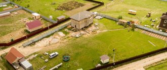
Also, information in the State Land Reserve is updated with information about the construction (appearance) of objects on the land that are indivisible with the site.
The responsibility for maintaining the state land cadastre is assigned to the Federal Cadastral Chamber (FKP) of Rosreestr. Data is stored both on paper and electronically.
If necessary, anyone can view the information they are interested in from the cadastre online on the Rosreestr website. But only the owner of the land plot can receive an official certificate certified by an official.
History of origin and development
First mentions of cadastral activities
Cadastral activity originated 3000 BC in Ancient Egypt . Even then, the Egyptians established clear boundaries of plots, determined their area and recorded this in their reporting. The system is maintained with the aim of obtaining and monitoring reliable information about the lands available in the country.
The word “cadastre” itself, according to the history of its origin, appeared in 27 BC in the Roman Empire. Then Emperor Augustus introduced a tribute for the population for the land used and at the same time established a census of the population, which was called “caputigum registrum”. Two words were combined into one - “capitastrum”, and then it was transformed into “catastrum”.
The modern cadastre appeared in 1718, invented by Giacomo Marioni.
The point is to take into account not only the lands and their boundaries, but also the quality of the lands, their purpose and the profit that its owner has from this plot. Based on such a cadastre, it was possible to fairly determine the amount of land tax.
History of development in Russia
In Russia, the state land cadastre begins to develop with the formation of Kievan Rus (IX – XI centuries). The collection of laws of those times “Russian Truth” contained information that all lands should be divided into :
- Yards (used for the construction of buildings);
- Arable (for growing crops);
- Empty (for pastures or just empty);
- Hunting grounds (forests, fields and swamps where game was found).
Qualitative assessment of land began to be used already in the 12th century, when, in addition to the specified classification, the quality of the land was separately noted depending on its fertility, presence of game, suitability for construction, etc.
In 1622, the Scribe Decree was issued, according to which the responsible scribes had to keep records of all the lands in their department. In addition to the regular census, it was necessary to indicate the owner of the land.
Based on this, the Scribe Books became a legal document , and the entries made in them were the primary evidence of land ownership.
The concept of “Land Cadastre” in Russia was first introduced in 1968 with the publication of the Land Code of the RSFSR.
Today, the features of maintaining the State Land Cadastre are regulated by two main bills :
- Federal Law “On Cadastral Activities”;
- Federal Law “On State Registration of Real Estate”.
Types of cadastres
Let's consider the types of cadastres: real estate, land, water, forest, minerals. Land and real estate are mainly in demand.
A land survey is conducted to identify a natural object; an identification number is assigned to the territory and coordinates are indicated to determine the location. Maintenance occurs according to the rules according to the technological process. The rules of the Land Code of our country require the maintenance and completion of this documentation.
The real estate cadastre is a systematized information base about real estate objects, territorial subjects of the Russian Federation, indicating the boundaries of cities and rural settlements. The peculiarity of this type of cadastre is the systematization and distribution of data on specific real estate objects. A person can order a cadastral passport for a plot of land at the cadastral service, at the MFC or on the government services website.
Water cadastre is a system of information about the country’s water resources: number, structure, purpose, compiled by water regions and basins.
Forest - a collection of information about the forest fund, its environmental, economic and other characteristics. Serves for forest management, its maintenance, changing the category of land, assigning fees for the use of the fund, assessing the activities of land management workers.
Minerals - an information base in the form of a system about the geographical location of minerals, their composition and anomalies. The purpose of the administration is to develop programs at the federal and regional levels for carrying out geological work to study the subsoil of the earth, the use of location, the justified location of processing and production enterprises and various works on their use.
For what purposes is it carried out?
First of all, the information contained in the State Land Cadastre is used to resolve the issue of proper use of land.
Based on the data of the State Land Committee, decisions are made on :
- Changing the intended use of land;
- Assigning tasks for a new way of exploiting land to increase the productivity of its use.
Also, based on SLC data, the use of land plots is monitored and an assessment is made of the effectiveness of potential actions that can be carried out with this land.
Taking this into account,
the objectives of the State Land Cadastre are :
- Land zoning;
- Registration of plots;
- Accounting for the quantity and quality of available land;
- Soil assessment (assessment of their fertility);
- Carrying out cadastral surveys.
All information received must be systematized, after which the main goal of the State Land Land Committee can be achieved: providing all interested parties with in-depth knowledge about the economic, legal and natural state of the entire land fund of the Russian Federation as a whole and each land plot separately.
Stakeholders as :
- Government authorities who are looking for ways to make the most productive use of land;
- Tax authorities, which, based on the cadastral value, determine the amount of land tax;
- Legal entities and individuals who use data from the State Land Register for their own personal purposes (for example, based on the area of the plot, its cadastral value and the type of permitted use, they determine the feasibility of acquiring land).
Definition of cadastre
A cadastre is a document in the form of a list or register, designated in the form of a map on which land plots and objects are listed.
To understand the essence of the cadastre, it is necessary to consider historical facts. During the reign of the Roman Emperor Augustus, a definition of the concept was formed. The terminology did not develop further, only at the beginning of the seventeenth century G. Marioni, taking the Roman cadastre as a basis, developed documentation based on scientific methodology. Cadastral documentation was represented by situational maps for each rural settlement. On the drawing table, he drew a map on which he highlighted the location of each rural community and the type of ground cover. The tax was calculated based on the drawing and the income of the settlement. In the mid-seventeenth century, the cadastral document was put into operation. European countries used it to develop state cadastral documentation.
In the tenth century in Russia, in order to justify the collection of land taxes and evaluate land holdings, a cadastre was introduced, called the Soshnoye letter. Cartographic characteristics of the list of land objects were included in the description: scribe, survey, boundary, patrol books. The source of filling was field work and land surveying.
The eighteenth century saw the expansion of powers for land owners and the strengthening of property rights through improvements in land cadastral registration.
In the mid-seventeenth century, a commission was formed to deal with state land surveying. The history of the development and approval of the cadastre reveals the essence of the term.
The cadastre is a list in which information is organized and systematized. For example, the state cadastre is a unified database compiled on the basis of current laws, represented by a set of data on economic indicators, systematized by characteristics.
Principles
Maintaining the State Cadastre is based on the following principles :
- Consistent organization of collection, processing, accounting and storage of information obtained through cartographic, assessment, topographic, land management, soil, cartographic, topographic, geodetic, geological and other types of work related to land registration.
- A unified cadastre system throughout the Russian Federation. At the same time, uniform methods are used to conduct cadastral activities, and uniform documents are used for reporting.
- Interaction of the SLC with other state cadastres: forestry, urban planning, etc. This is necessary to collect all the necessary information about the property into one whole.
- Continuity of cadastral activities. Periodically, new information must be entered into the State Land Register: registration of land, assignment of a new cadastral value.
- Reliability of information . The entered data should always reflect the existing reality. Thus, Rosreestr revises the cadastral value of each land plot at least once every 5 years.
- Completeness of information . All registered lands are systematized according to a single principle. Their area is determined, a cadastral number (CN) and cadastral value are assigned, etc. Skipping one or more lines when filling out information is not allowed.
- Maintaining civil and civil rights records on electronic and paper media and their equal importance. But if there are discrepancies for the same section, the version indicated on paper is considered correct.
- Permanence of data storage . Information from the State Land Register cannot be deleted. It can be updated, supplemented, changed, etc., but old data is not deleted, but remains in the storage of the responsible service.
- Organization of work from the bottom up . All basic information is supplied to the SLC by lower, local structural units. This means that any optimization of activities should first of all be aimed at the lower levels of the cadastral service.
- The Civil Land Code is the basis for resolving most land disputes. The data specified in the cadastre can only be challenged through court.
- Availability of data from GZK . Anyone can obtain the information they are interested in on a land plot registered by Rosreestr.
- Centralization in management . Any decision made by the head of the cadastral chamber is binding on all territorial departments of the cadastral service.
Receipt procedure
Important! When submitting documents, you must bring originals (a copy will be made of them and they will be returned immediately) or notarized copies.
An employee of the cadastral chamber or MFC will accept the documents, issue a receipt with a list of those accepted and set a date for receiving the finished document.
It takes 18 days to issue a cadastral passport if the documents are submitted to the cadastral chamber, or 20 - 25 days if to the MFC.
After this period, a passport or extract is issued confirming the inclusion of the property in the state real estate cadastre.
If a division or allotment of an object is made, all parts must be registered at the same time, because at the same time the process of cessation of the existence of the divisible property also occurs. If the registered land (structure) is not registered, then temporary registration is issued for a period of two years. During this period, rights to the object must be registered. If the rights are not formalized within the specified period, the plot is canceled.
What information does it contain?
GZK objects
The objects of the State Land Code are all land plots located within the borders of the Russian Federation and registered .
In addition, there are still unregistered lands that are also located within the borders of the Russian Federation. Until the plot is registered by the Federal Cadastral Chamber, it cannot be sold, rented, donated, etc. Registration of new lands is carried out as necessary.
Composition of information
All information contained in the State Land Code is divided into the following components by category :
- Separate land plots;
- Territorial zones;
- Borders of districts, regions and other municipalities;
- Borders of the constituent entities of the Russian Federation;
- State borders.
The last 4 categories include information on the boundaries of the object (whether it is a territorial zone or a municipality) and its name.
The category “Land” contains the following information :
- Cadastral number. Assigned to all registered real estate objects without exception.
- Location of the storage unit (its exact address).
- Area in square meters.
- Type of permitted use of the allotment.
- The category of land it belongs to.
- Precise indication of boundaries.
- Availability of registered rights and restrictions.
- Cadastral value.
- Qualitative indicators (for example, soil fertility);
- Real estate that is indivisibly connected with the land plot.
Procedure for maintaining the accounting system
When maintaining the State Land Cadastre, it is necessary to be guided by the above principles, the main of which are: organization of work from the bottom up and a unified system for maintaining civil land registration throughout the Russian Federation.
The main unit of the cadastral service is local offices , which, according to the established model and within the established period, carry out activities to collect information and enter it into the database.
In addition, the responsibilities of local branches include working with citizens (other interested parties), which means providing the necessary information and issuing requested certificates in accordance with the established procedure.
Where and how to apply?
In order to enter your land property into the state real estate cadastre, you must contact the cadastral chamber or the Multifunctional Center (MFC) in the same locality as the registered object. To submit an application, you must have certain documents with you:
- passport of a citizen of the Russian Federation (if the registering person is an individual);
- constituent documents (if the registering party is a legal entity);
- application (provided along with a sample form at the cadastral chamber/MFC);
- receipt of payment of the state duty (the amount can be clarified in the bank where it is paid);
- documents confirming the right to the property in question;
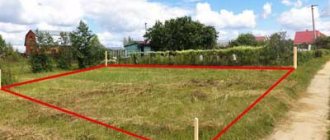
- boundary, geodetic plan (for land plots);
- technical passport (for registration of houses);
- consent of the ministry/committee for property management (when registering a municipal/state facility);
- consent of the guardianship authorities (if necessary).
Important! When registering a privately owned property, you should consider the following:
- if the owner registers, but the property has tenants, then their written consent is required;
- If tenants register, then the written consent of the owner is required.
You should contact the cadastral office for samples.
Basic documentation
All documents used in maintaining the State Land Cadastre can be divided into three groups :
- Basic;
- Auxiliary;
- Derivatives.
All documents are prepared according to a single standard, regardless of the region of the country.
Basic includes :
- Register of lands of the cadastral region . Consists of several separate forms. Designed to fill out information about land plots obtained in the process of cadastral activities.
- Cadastral plans . Maps maintained in electronic and paper versions with detailed indication of the boundaries of the territory, territorial zones, etc.
- KN accounting log . Cadastral numbers of all registered land plots are recorded.
- Cadastral affairs . Filing of all documents related to the cadastral registration of land plots.
Supporting include :
- Book of accounting of incoming documents;
- Book of accounting of issued information.
Derivative documents include certificates (other documents) issued and certified by the cadastral service itself. These can be cadastral passports, statistical reports, etc.
As mentioned above, cadastral activities are characterized by the unity of the documents used. This means that all cadastral services compile the specified documentation according to the general template approved by Rosreestr.
WHY DOES A PROPERTY OWNER NEED CADASTRAL REGISTRATION?
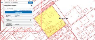
The relevance and benefits of housing registration are discussed above in the article. After assigning a cadastral number, the land plot is plotted on the public map of the Russian Federation, which will help in the future in making real estate transactions. From the map you can determine the exact address, type of landscape, nearby buildings and surroundings. The card was created back in 2010, but not every person uses its capabilities. The main benefit is that at home you can determine the location of the charger.
In this case, a cadastral number is assigned in the following cases - in relation to unaccounted land plots, and also for which no limits have been established. Situations are possible when a person has registered ownership of real estate, but there is no fact of land surveying. If a person plans to purchase real estate, at the stage of checking it, knowledge of the cadastral number is required, because documentation alone is not enough for the assessment. At the same time, it is not recommended to take land plots for which boundaries have not been defined; there is no act of acceptance and transfer of boundary marks.
Legal regulation
Article 70 of the Land Code of the Russian Federation states that cadastral activities related to land plots are regulated by the Federal Law “On State Registration of Real Estate”.
In addition, the legal regulation of the land cadastre is carried out on the basis of :
- Constitution of the Russian Federation (Article 5, , , , , , , , );
- Civil, Land, Forestry, Water and Housing Codes;
- Federal laws: No. 221 (partially repealed), No. 122, No. 101, No. 172;
- Orders of the Ministry of Economic Development;
- Government regulations;
- Laws of individual subjects of the Russian Federation.
A detailed scheme of legal regulation is presented in the figure.
Until January 1, 2021, all the main features of maintaining state cadastral registration of land plots were regulated by Federal Law No. 221. As of 2021, this Law only contains information about the role of cadastral engineers.
All other provisions lost force with the beginning of the use of the Federal Law “On State Registration of Real Estate”.
Why is this being done?
All Russian land and all structures erected on it must be registered, because in this way a citizen confirms the presence or absence of land ownership. In this regard, its taxes are formed. In order to collect taxes fairly and promptly, the government needs to know about a citizen's land ownership.
If a citizen owned property before the introduction of cadastre laws, the right to it remains, but any transactions or transactions with it are impossible until it is registered with the state cadastral register.
There are different types of cadastres, but in this article only one will be considered - land cadastres. This type of cadastre also includes all structures erected on land property. There are several reasons for entering possessions into the state real estate cadastre:
- separation of one area from another;
- the emergence of a new site;
- division of one property into several;
- construction of a building, premises;
- redevelopment, allocation of rooms indoors;
- division of the structure (if it passed to several owners through shared donation);
- any changes made to the land or structures on it;
- transfer of premises from non-residential to residential and vice versa.
Purpose of the State Cadastre Service
The Land Cadastre Service performs the following functions :
- Registration of land plots (other real estate objects). Registration of new lands is carried out at the request of interested parties. For example, a legal entity wishing to lease a plot of land.
- Accounting for cadastral value data. At least once every 5 years, the cadastral value of all land plots must be revalued. The task of the cadastral service is to record all changes in the valuation of land plots determined by independent appraisers.
- Providing registered information to all interested parties (government authorities, citizens, etc.).
Registration of a real estate property based on the results of a caducity test
Object accounting makes it possible to secure rights to a site or object. This procedure is also carried out through Rosreestr, and it can be combined with accounting actions. Stages of the registration procedure:
- the copyright holder prepares the basis documents for registration (commissioning or acceptance certificate, technical or boundary plan, other documents);
- an application is submitted to Rosreestr or MFC;
- Rosreestr employees check the compliance of documents with Law No. 218-FZ and transfer the information to the Unified State Register of Real Estate;
- the object is assigned a cadastral number;
- after completion of the registration, the applicant receives an extract from the Unified State Register.
The extract is a document of title. It can be used to check information about real estate and make transactions. During the process of ownership, you can repeatedly go through registration if the initial characteristics of the object change. To do this, you need to contact an engineer every time for cadastral documentation.
Kinds
The vertical of the land cadastre service has 4 levels:
- Federal Center for Land Cadastre . Today, this function is performed by the Federal Cadastral Chamber of Rosreestr. From here, decisions are made to optimize the activities of the entire cadastral service.
- Regional land cadastre . Presented in the form of branches of FKP Rosreestr in each region. The main function is to ensure communication between the Federal Center and the lower levels of the cadastral service. Regulates the activities of city and district services in its region.
- City land cadastre . Engaged in cadastral activities directly on site, also controls the lowest level of the cadastral service.
- District land cadastre . Carries out cadastral activities on site.
The concept of “land” in legislation
Before considering the features of the land cadastre, it is necessary to dwell on the concept of “land”. The term “land” is understood as “... the most important part of the natural environment, characterized by space, relief, climate, soil cover, vegetation, subsoil, water, which is the main means of production in agriculture and forestry, as well as the spatial basis for the location of enterprises and organizations all Considering the features of the land cadastre, it is necessary to stop at the concept of “land”. The term “land” is understood” ... as the most important part of the environment, which is characterized by space, space, climate, soil cover, vegetation, subsoil, water, being the main means of production in agriculture and forestry and also the spatial basis for the location of enterprises and organizations of all industries national economy” (GOST 26640-85). Unlike soil, which is considered as a natural-historical bioinert organization, land is a territory that is used for specific purposes; those. this is a broader concept. The land is valued, on the one hand, from the point of view of an economic assessment of its quality as a means of agricultural and forestry production; on the other hand, in terms of its result based on an assessment of the factors of abundance.
Reserve – (from lat.capitastrum reserve, register of submitted documents; later in France this word was transformed to “cadastre” - register), code of systematized data on a land use object, defining the functional and purpose of a certain quality of taking into account a plot of land (site class) , current condition and cost in case of purchase and sale.
The state land cadastre is a system of accounting, assessment of lands established by the state and registration of land rights, aimed at regulating and improving land relations and including data on the legal, economic and economic, environmental and natural conditions of lands.
Removal
According to No. 218-FZ, a plot of land can be deregistered on the following grounds:
- the territory consists of lands of state and municipal significance and no rights or encumbrances have been registered on it;
- the area of the allotment changes;
- the land was registered more than 2 years ago, and during this time no one registered the right of ownership or use of it;
- the plot was put on temporary registration more than a year ago, but the rights to it were not legalized.
In addition, the procedure can be carried out by court decision. Most often, this is due to the fact that the owner does not use the plot and does not want to continue paying taxes on it (you can find out how their amount is calculated based on the cadastral value of the land plot here).