Pravozhil.com > Real estate registration > Land registration > Correct declaration of the area of a land plot - what is it?
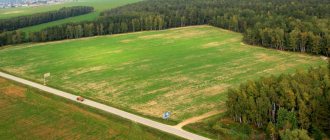
When owning a plot of land in a gardening cooperative, the question of land surveying and establishing boundaries with neighboring plots often arises.
This results in a decrease or increase in the boundaries of the site. The declared area of a plot of land is an opportunity to avoid possible future misunderstandings both with neighbors on the site and with government agencies.
Declared plot - peace of mind for life
What is the declared area?
Twists of fate sometimes bring unexpected surprises and changes in the boundaries of a land plot, as well as legal proceedings challenging the legality of land surveying are one of them.
Such unpleasant processes may occur:
- when dividing property;
- when re-registering a gardening partnership;
- when neighbors challenge the boundaries of the site;
- when challenging the legality of construction;
- upon presentation of claims by government authorities;
- when privatizing a site;
- the occurrence of technical errors in cadastral registration and the presence of intersections of borders of adjacent lands;
- difference in area in documents.
According to the law, the declared area of a land plot is the specified boundaries of the land, documented and confirmed by specialists. Once this process has been carried out for such a site, it is almost impossible to challenge its boundaries.
It is also difficult to challenge the boundaries of a plot registered in the cadastral register, since its boundaries have already been agreed upon with government authorities.
Filing a declaration
Registration is carried out if it is necessary to indicate the boundaries of land plots in Rosreestr, taking into account the site plan. Their clarification is recorded in the declaration and is necessary in order to enter reliable coordinates into the title documents. The declaration must be preceded by mandatory agreement on the location of the borders.
Submitting a declaration to Rosreestr may be slowed down by possible land conflicts. A neighbor may believe that another has appropriated a fragment of his territory.
In such a situation, the land management company must carry out “removal of points on the ground”:
- Specialists establish turning points on the ground, information about which is recorded in the state register.
- Turning points are fixed by designated boundary markers. The installation of boundary signs visually indicates the real border of the land.
- Next comes the oral stage of negotiations with the neighbor, and if the conflict cannot be resolved through contractual means, the parties go to court.
Filing a declaration may be difficult due to unclear property boundaries. The land owner may not have an idea of the technical boundaries of his plot, and therefore the cadastral passport lacks the necessary information about the boundaries.
The presence of declarative boundaries becomes the cause of land disputes. The parties need to begin the process of land surveying. The actual areas of the plots are compared with the indicators specified in the documents. Areas around the disputed object can be compared.
In a similar way, it can be established that the seizure of part of the land took place in another place. Boundaries are determined using geodetic surveying. In its process, the position of buildings relative to actual boundaries can be determined. It is necessary to find out the real boundaries of the site in order to establish the fact that the neighbor violated land legislation during the construction of a residential or commercial facility.
Created boundary plans and signs help protect property rights. This helps to protect the land from the interests of unscrupulous business entities.
Features of filing a declaration are established depending on the category of land. The boundaries of the site may overlap each other, which requires the help of a specialist to coordinate the location of the disputed objects.
Declaration of borders cannot be carried out without verification activities. Determining boundaries in cadastral registration requires documented and schematically confirmed sources. Disputes are resolved in court. When resolving land legal disputes, Rosreestr is involved in the legal process as a third party.
Declaration of boundaries can be carried out not only by the owner, but also by the tenant of the land. Opportunities are provided for long-term lease for the construction of a residential building or industrial facility. It is common to submit a declaration when agreeing on the boundaries of land in dacha and garden partnerships.
The actual presence of boundary markers and approximate information about boundaries during legal proceedings can be supported by expert opinions. Timely clarification of boundaries will eliminate the need for land conflicts with neighbors. This will allow you to use the site for its intended purpose and timely draw up legal documentation for it.
When owning a plot of land in a gardening cooperative, the question of land surveying and establishing boundaries with neighboring plots often arises. This results in a decrease or increase in the boundaries of the site. The declared area of a land plot is an opportunity to avoid possible future misunderstandings both with neighbors on the site and with government agencies.
What does the law say about land declaration?
Legislation on land declaration
If there is a certain requirement, then this requirement is legislated.
It simply cannot be any other way. Federal Law “On the State Real Estate Cadastre” No. 221 FZ of 2007 determines the procedure for declaring the area of land.
Order of the Ministry of Economic Development of the Russian Federation No. 628 of 2010 determines the form for submitting a declaration and an application for declaring real estate, which can include a plot of land.
This normative act refers to precedents in land disputes, when it is necessary to challenge the errors of surveyors. This need arose due to the fact that most areas were measured “by eye”.
The accuracy of the instruments left much to be desired. Today, the measurement and accounting system is synchronized, which reduces the risk of introducing errors into documentation.
How to convert area from one unit to another
Most units can be either linear or square quantities:
- linear are used to determine the sizes of objects and distances;
- square - for measuring the areas of geometric shapes, rooms, buildings, land plots.
But measures such as acre, are and hectare have no linear analogues and relate to purely land measures.
Brief historical background
Let's look at the history of some units of area measurement.
- The origin of the land measure, the acre, has a funny story. Initially, an acre denoted the size of a plot of land that could be cultivated in a day by one peasant using the draft power of one ox.
- The mile originates in ancient Rome. It was equal to a thousand double steps taken during the march by warriors dressed in full battle dress.
What land measures are used in Russia
In Russia, the following units of area are mainly used as land measures:
- hectare (ha);
- square meter (m2);
- ar/sotka (a).
- In the Russian Federation, a hectare is used to measure the area of land plots with a designated purpose - agriculture or forestry. A hectare is a square whose side is 100 m or 0.1 km.
- The square meter can be widely used as an international system unit. Used to determine the area of rooms, apartments, buildings, structures, land plots intended for settlements, etc. One m2 is the area of a square with a side equal to 1 m.
- Ar (weaving) is practically not officially used today, but in everyday life it is still found quite often as a unit of area of a land plot for individual housing construction. One are is equal to the area of a square. with a side of 10 m, that is, 100 m2. (This is where the term “weave” itself came from).
Unit conversion tables
You can convert one unit of area to another using various conversion tables and simple calculations.
For example, you need to convert 700 ares to hectares. Let's make a proportion:
1 ha - 100 a
x ha - 700 a
x = 700/100 = 7 hectares.
Answer: 700 ares (acres) are equal to 7 hectares.
Methods for clarifying land boundaries
How to determine the boundaries of a land plot?
Speaking about the improvement of technical capabilities, it is worth mentioning that the methods of land surveying and clarification of land plots have also changed.
Currently used:
- geodetic methods;
- application of satellite data;
- photogrammetric methods;
- cartometry methods.
These methods can be used individually or in combination. Everything depends solely on the location of the land plot and the purpose of the cadastral survey.
Average minimum plot size by region of the country
The current minimum lot size is as follows:
| No. | Name of region or city | Minimum land plot size |
| 1. | Leningrad region | 0.05 ha |
| 2. | Moscow region | 400 m² |
| 3. | Primorsky Krai | 0.2 ha |
| 4. | Tatarstan | From 6 acres |
| 5. | Yakutia | 10 m² |
| 6. | Khabarovsk | 400 m² |
| 7. | Chelyabinsk | 0.5 ha |
| 8. | Sakhalin region | 0.1 ha |
| 9. | Bryansk | 450 m² |
| 10. | Omsk | 0.04 ha |
| 11. | Rostov-on-Don | 600 m² |
| 12. | Nizhny Novgorod | 3 acres |
| 13. | Pyatigorsk | 500 m² |
| 14. | Novosibirsk | 0.045 ha |
| 15. | Ekaterinburg | 400 m² |
As you can see, in the same district, but in different areas, the minimum size of a land plot may vary. You can find out about the allotment values accepted in your locality from the local administration.
So, the minimum size of the plot is necessary to carry out various operations with it. When allocating a new plot, you need to focus on the lowest land standard accepted in this region. Otherwise, it will then be impossible to register ownership of this property.
https://youtube.com/watch?v=nrIBRN-52L4
Declared area of land - what does it give?
Due to the fact that the declared plot is included in title documents with specific boundaries, and is also entered into the general state system for recording land plots, a number of advantages arise:
- the owner receives documents that confirm his sole ownership;
- the owner receives a state act that guarantees the indefinite possession of such a plot and the conduct of legal operations in relation to it;
- the boundaries of the site cannot be disputed by either party;
- the land plot cannot be transferred to the right of ownership, disposal or lease to other persons.
Statement of claim and attached documents
Before applying to the district court to clarify the boundaries of a plot of land, the applicant must familiarize himself with the legally correct form of the statement of claim. When filling out, you must adhere to the following rules:
- Heading of the statement of claim - indicates the judicial body to which the petition is sent, contacts of the plaintiff or his representative, and the defendant. When paying the state fee, its amount is indicated.
- The title of the document, “Statement of Claim to Establish the Boundaries of a Land Plot,” is located in the middle and there is no period at the end of the sentence.
- Contents - information about the land plot owned by the plaintiff, its exact address, numbering according to the cadastre, information about the carrying out of boundary work are indicated. The places where the boundaries of the allotment were violated and the reasons for their restoration are also noted.
- Legislative acts and articles serving as the basis for making a decision.
- Definition of a request:
- recognize the information included in the cadastral plan as erroneous;
- establish boundaries between land plots under No. No.;
- Appendix with a list of supporting documents to confirm the stated facts:
- situational plan;
- title deed;
- extract from the cadastre, certificate or plan;
- any documents issued by the authorized body and confirming the location of the site and boundaries.
- act of approval of boundaries;
- receipt of payment of state duty;
- representative's power of attorney (if necessary).
- At the end of the statement of claim, the date and personal signature of the plaintiff, as well as a transcript of the initials, are placed.
The location of the borders can be confirmed by any documents issued by the authorized body and confirming their location.
The process of registering a site
After receiving, purchasing or leasing a certain plot, questions may arise regarding its boundaries, because even when renting, the amount of payment depends on the lease of the land, and if it is taken with the right of subsequent purchase, then registration of the plot is desirable, but not mandatory.
The area of the land plot that is subject to declaration will be taken into account after completing the survey procedure, registration and registration.
First, you need to submit an application to the cadastral chamber to determine the exact boundaries of the land plot. You can submit an application:
- tenant;
- heir;
- owner of the land.
The application is reviewed within five days. After this period, a decision is made to carry out cadastral work.
In case of refusal, the applicant can go to court and carry out the same actions through the courts. However, the court is not a source for declaring a land plot, since it is only an alternative to registering a plot of land.
Thus, it is clear that in order to guarantee the preservation of one’s rights to a land plot, the declared area is necessary. Having clear boundaries and a legally established area, the owner can be calm about the fate of his land plot.
You can find out the opinions of experts regarding land surveying by watching the video:
Conclusion
Declaring the area of a land plot allows landowners to become full owners. Thus, a plot that does not have clear boundaries cannot be sold or leased, sold or donated. Problems with taking over property rights may also arise for the heirs of the land user.
As a result of declaring and clarifying the boundaries of the site, the owner becomes the sole owner and receives a set of title information. The boundaries of a registered plot are almost impossible to challenge.
Thus, in modern cadastral registration practice the concept of declaring a plot of land is not used. Those lands that were previously called declared are today considered areas with undefined boundaries. In order to fully dispose of your plot, it is necessary that its boundaries acquire the status of “specified”. It is assigned after additional boundary work has been carried out and the area of the site has been determined.
Dear readers, the information in this article may be out of date. If you want to find out how to solve your particular problem, call:
- Moscow.
- Saint Petersburg.
Or on the website. It's fast and free!
Industry news
(hereinafter referred to as an error in the location of the border of a previously registered land plot) can be corrected by the cadastral registration authority using procedures in accordance with Part 14 of Article 45 of the Cadastre Law. At the same time, before the adoption of departmental regulatory legal acts that determine the procedure for clarification by the cadastral registration body of the location of the boundaries of previously registered land plots, as well as the requirements for the forms and scale of the cartographic basis of the state real estate cadastre, on the issue of correcting an error in the location of the border of a previously registered land plot, the following should be noted. If a border crossing is identified due to the presence of an error in the location of the border of a previously registered land plot, the cadastral registration authority must make a decision to suspend the implementation of state cadastral registration, which includes recommendations from the cadastral registration authority on finalizing the boundary plan submitted for the implementation of state cadastral registration.
Mystery 2. How much land is there really?
The expert also notes that you can find out about the area of the site and whether land surveying was carried out using a public cadastral map on the Rosreestr website. On the map itself, at the top left there is a “search engine” - a window with a magnifying glass in which you need to enter the cadastral number of the plot of interest to you. It (the site) will be displayed on the screen, in addition, a window will open in which there is a block of information about the object, including the category of land, permitted use and dimensions. The indication of the area may indicate “Specified area”, this means that land surveying has been carried out. If “Declared area” is indicated, then land surveying still needs to be done.
Secret 3. Is it possible to live here?
Earlier, the portal METRTV.ru talked about how transactions with land plots are processed after Law 218-FZ comes into force on January 1, 2021. This law, in particular, will not allow registering the purchase/sale of a plot that is not included in the Unified State Register of Real Estate. Although previously a situation could have arisen when a person who bought a plot, after the transaction was completed, put the documents on the land in order.
Therefore, before thinking about whether it is possible to insure an unregistered holiday home, you should keep in mind that this will be a legally unformed insurance contract, so you should not count on compensation.
The question of whether it is worth investing in the land surveying procedure, even despite the unequivocal answer from the law, remains open. The land is on the cadastre, title to it has already been registered, and all title documents are available. Is it possible to leave everything as is and not survey the area?
Is it worth deciding?
Even if you make absolutely no trades, you may still encounter difficulties. For example, building a new house or renovating an old one requires obtaining permits. Without a boundary plan, this will be extremely difficult to do. Also be prepared for the fact that no communications can be made to such an area. This also requires permission.
The seller must have a certificate of registration of title. It indicates the area that the state recognizes for the given owner. You can also request an extract from the Unified State Register (essentially an official copy of the certificate of entitlement). It would not hurt to check the title documents on the basis of which the registration of the right was carried out. [ Nikolaev Denis (developer) ] Sunday, August 17, 2021, 13:07 how are these areas different? clarified from declared? A plot has a so-called declared area (the area from the title document) if the location of its boundaries is not established in accordance with current legislation (unspecified plot). After the clarification work has been carried out, the site receives a revised area (obtained from measurement results).