Technical plan or technical passport: what to choose for state registration?
How not to get confused by similar names of documents and choose the one necessary for registration actions, explained in the cadastral chamber of the Yaroslavl region.
Technical passport is a document on the basis of which registration of residential buildings was carried out until 2012.
Important! A technical passport is not a title document. However, its scope is still wide. Data on changes after reconstruction or redevelopment are entered into it and used (copies are made) as a source of technical information about communications (electrical network, heating, sewerage, etc.) and equipment during design. Based on the passport, operational documentation is created. For example, to prepare for repairs.
“The passport contains the key parameters of the property. It records floor plans, locations of window and door openings, and communication diagrams. For example, a technical passport and its copies are used to coordinate construction and repairs,” explains expert of the Yaroslavl Cadastral Chamber Vladimir Fomin .
Since 2013, the basis for cadastral registration is the technical plan.
“The technical plan is a relatively new document, which for the purposes of state cadastral registration of capital construction projects. It replaced the technical passport,” says Vladimir Fomin.
The technical plan reproduces certain information entered into the Unified State Register of Real Estate, and indicates information about a building, structure, premises, an unfinished construction project or a single real estate complex necessary for the state cadastral registration of such a real estate object.
A technical plan is required in the case of the initial registration of an object for cadastral registration, to take into account changes in information about the object, to take into account changes in information about parts of the object (formation of a new part), to put the object into operation.
Primary registration implies accounting for a newly created property. Accounting for changes in information is carried out when one of the unique characteristics of the object changes (area, layout, purpose, etc.).
“Information in the technical plan is included on the basis of the cadastral work of the building design documentation submitted by the customer, a construction permit, a permit to put the building into operation, or a technical passport of the building produced before January 1, 2013,” the expert emphasizes.
The document is prepared by a cadastral engineer. He visits your property and takes the necessary measurements. Next, it forms a technical plan, which includes a graphic and text part.
The technical plan, drawn up in accordance with current legislation, is transferred to the customer on an electronic medium signed by a cadastral engineer for submission to Rosreestr.
“Despite the apparent identity of the technical passport and technical plan, they not only differ in content, but also serve different purposes. The technical plan includes the ability to determine the location of the property. Therefore, unlike a technical passport, a technical plan in its graphic part will contain a drawing that includes the numbering of turning points, as well as documents defining the location of the object within the boundaries of the land plot,” notes Vladimir Fomin.
The validity period of the technical plan, like the validity period of the technical passport, has no restrictions. The documents are relevant as long as the technical condition of the property has not changed.
Preparation of a technical passport for a capital construction project
Today, the basis document for making changes to information about a property in the Unified State Register is not a technical passport, but a technical plan of the property prepared by a cadastral engineer.
At the same time, a technical passport can be prepared for other purposes that do not provide for its use as a basis document for entering information into the Unified State Register of Real Estate.
A technical passport is an information and reference document showing the actual condition of a property. A technical passport is produced, as a rule, for official (personal) use and is used for various purposes: for personal purposes, for guardianship and trusteeship authorities, for a bank, for a court, for architecture, etc.
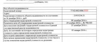
The technical passport records:
- actual location (address) of the object;
- its owner (owner);
- inventory value of the object;
- technical characteristics of the object - year of construction of the building, year of last major renovation, number of floors in the building, characteristics of the apartment (number of rooms, ceiling height), wall material, floor material, type of heating, presence of water supply, sewerage, etc.;
- inventory, register, cadastral numbers;
- graphic section – drawing;
- a note confirming the entry of information about this property into the Register of Real Estate Objects.
The technical inventory of real estate objects consists of checking and determining on a specific date the availability, location, purpose, actual use, composition, condition and value of the object. The technical inventory of accounting objects is divided into primary, planned and unscheduled.
Preparation and execution of a technical passport is the result of a technical inventory of capital construction projects.
Technical inventory of capital construction projects is divided into:
- primary technical inventory;
- technical inventory of changes in the characteristics of a capital construction project.
The unit of technical inventory is: building, structure, premises.
The requirements for filling out and the procedure for reflecting information about a capital construction project, as well as a land plot in the technical passport, are regulated by the “Instructions on accounting of housing stock in the Russian Federation”, approved by the Order of the Ministry of the Russian Federation for Land Policy, Construction and Housing and Communal Services dated 08/04/1998 No. 37 (hereinafter – Instructions).
Accounting and technical documentation can be carried out both on paper and on magnetic media. If data inconsistencies are identified, paper data takes precedence.
Work under Section 2 of the Instruction “Surveying a land plot”, in the presence of land plot plans prepared by the land resources and land management committees, is carried out by technical inventory organizations in terms of missing measurements. If there are plans for land plots, it is not allowed for organizations to carry out a technical inventory of repeated surveys of these plots. When inspecting a land plot of a household, the plans of previously carried out geodetic surveys are used as much as possible. All measurements of the land plot carried out during its survey are entered into the outline of the land plot.
All boundaries of the site are measured along their entire length, and in the case where the boundaries are built up and it is not possible to carry out work in the usual way, it is necessary to take measurements in parts or parallel to the boundary. Each plot of land has physical boundaries, closed (fences, fences, buildings, structures) and open (ditches, boundary signs, landmarks, etc.). The plot is measured along the center lines of fences located between plots, and along the outside of fences facing streets, driveways, squares, etc. In the absence of landmarks, without which it is difficult to establish the boundaries of land plots, the inventory surveyor must be guided by the situation, as well as by interviewing the owners (users) of the surveyed and neighboring plots, establishing the boundaries conditionally (about which a corresponding note is made in the outline). The measurement of the boundaries of the site is carried out with the simultaneous measurement of buildings, structures and structures located within the boundaries of the land plot, starting from the facade of the main building and moving from left to right along the perimeter of the site to the starting point.
The following are applied to the Land Plot Plan:
- linear measurements of the extent of boundaries, taken from the outline, without dimensional arrows at the middle of the measurement lines;
- external dimensions of buildings on the plan (as a rule, they are placed outside the outline of the buildings);
- all buildings with all extensions, vestibules, galleries, stairs, porches, pits and so on, as well as all structures: wells, fences, paving and contours of various lands.
The area of a land plot and its individual parts (buildings, garden, vegetable garden, etc.) is calculated based on measurement data by dividing the plot into simple geometric shapes (triangles, trapezoids, etc.). With a complex configuration of areas, the area can be calculated using a planimeter.
When carrying out work on preparing a technical passport, it is also necessary to determine the technical condition (physical wear and tear) of the building, structure, structure.
Determination of the technical condition is carried out simultaneously with the technical description of the building. At the same time, signs of the technical condition (physical wear and tear) of parts of the building accessible to inspection are identified.
Physical wear and tear refers to the loss of the materials from which the building is constructed of their original qualities.
The percentage of physical deterioration of buildings, depending on the accessibility or inaccessibility to inspection of its structural elements, is respectively established according to the characteristics of the technical condition or calculated according to service life.
Based on external signs of the technical condition of individual building structures, physical wear and tear is established in accordance with the rules of “Assessing the physical wear and tear of residential buildings” VSN-53-86(r) of the USSR State Civil Engineering, and then wear and tear is determined for the building as a whole.
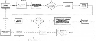
Table of the production business process “ Preparation of a technical passport for a capital construction project ”
| No. | Stage of work | Responsible for execution of work | Input Requirements | Output requirements | Deadline |
| 1 | 2 | 3 | 4 | 5 | 6 |
| Traveling to the site of full-scale survey and measurements and taking measurements | Surveyor/Cadastral Engineer | - Case by order; — Source documentation (if available). | - Case by order; — Source documentation (if available); — Catalog of coordinates of boundary points and boundaries of the contour of a building, structure, object of unfinished construction | 1-3 working days (depending on the amount of work). | |
| Measurements of the room and drawing up an outline | Surveyor/Cadastral Engineer | - Case by order; — Project documentation (if available). | - Case by order; — Project documentation (if available); — Outline with the dimensions of the room | 1-3 working days (depending on the amount of work). | |
| Preparation of a technical passport | Cadastral engineer | - Case by order; — Project documentation (if available); — Catalog of coordinates of boundary points and boundaries of the contour of a building, structure, object of unfinished construction — Outline with the dimensions of the room | - Case by order; — Technical passport of the object | 1-3 working days (depending on the amount of work). | |
| :TOTAL | 3-6 working days (depending on the amount of work). | ||||
Cadastral activities
The technical passport of a capital construction project is an important document required for many legally significant actions with real estate: mortgage purchase and sale transactions, inheritance, donation, approval of redevelopment, reconstruction, allocation of a share in kind or division of a real estate property.
Work on technical inventory includes determining the location, legal and physical boundaries of the object, obtaining information about the quantitative and qualitative composition, technical condition, level of improvement, and determining the inventory value.
Types of jobs:
- Technical inventory of real estate - buildings and premises (residential buildings, apartments, garages, etc.)
- Technical inventory of real estate objects - structures (industrial facilities, linear objects, etc.)
Required minimum set of documents:
- Identity document
A technical plan is a document containing the necessary information about a building, structure, premises or an object of unfinished construction, necessary for registration with the state cadastral register, or for making changes to the information of the State Property Committee, in case of changes in the characteristics of the real estate object.
Technical plan
The technical plan is prepared in order to obtain a cadastral passport for a real estate property from the cadastral registration authority (Article 22 of the Federal Law of July 24, 2007 No. 221-FZ “On the State Real Estate Cadastre”)
Required minimum set of documents:
- Preparation of a technical plan of the premises. Technical passport of this premises (issued before 01/01/2013), or design documentation for the building, or a declaration on the property, completed and signed by the owner of the premises or building in which the premises are located. In case of changes in the parameters of the premises (for example, total area, configuration, etc.), a document is required on the basis of which the changes were made (for example, permission to enter after redevelopment, a conclusion based on the results of an examination confirming that load-bearing structures are not affected, etc. ).
- Preparation of a technical plan of the building. Permission to put a building into operation, or a technical passport of this building, issued before 01/01/2013, or project documentation, or a declaration on the property, filled out and signed by the owner of the building or land plot on which this building is located. You will also need a cadastral extract of the land plot on which the building is located. If the land plot under the building has not been formed, it is necessary to submit a cadastral plan of the territory.
- Preparation of a technical plan for the construction. Permission to put this structure into operation, a technical passport issued before 01/01/2013, a declaration on the property, filled out and signed by the owner of the structure or land plot on which this structure is located, design documentation for the structure, cadastral extract of the land plot on which where this structure is located, or the cadastral plan of the territory, if the land plot under the structure has not been formed.
- Preparation of a technical plan for an unfinished construction project. A technical passport for an unfinished construction project, issued before 01/01/2013, or project documentation, or a declaration on the property, completed and signed by the owner of the facility or the land plot on which this facility is located. You will also need a cadastral extract of the land plot on which the unfinished construction project is located. If the land plot under the object has not been formed, it is necessary to submit a cadastral plan of the territory.
An inspection report is a document in which a cadastral engineer, as a result of inspecting the location of a building, structure, premises or an unfinished construction project (UCS), taking into account the available cadastral information about such a property, confirms the termination of the existence of the CCS due to the death or destruction of such a property, or termination of the existence of the premises due to the death or destruction of the building or structure in which it was located, the destruction or destruction of part of the building or structure within which such premises were located (Article 42 of the Federal Law of July 24, 2014 No. 221-FZ “On state real estate cadastre").
An inspection report is prepared with the aim of removing the object from the state cadastral register.
Required minimum set of documents
- an extract of data (cadastral passport) from the State Real Estate Cadastre for this property;
- other documents (title, title) reflecting the characteristics of the object.
The following services are provided in this area:
- Geodetic measurements of land boundaries;
- Making a boundary plan;
- Demarcation, consolidation of land plots;
- Land survey;
- Drawing up conclusions on the presence or absence of buildings on a land plot;
- Drawing up diagrams of the location of the land plot on the cadastral plan of the territory;
- Preparation of an explanatory note for the layout of the land plot;
- Restoration of the boundaries of the land plot on the ground (removal of turning points into nature);
- Preparation of preliminary survey materials (cadastral engineer’s report);
- Preparation of an agreement to determine the procedure for using the land.
Required minimum set of documents:
- Identity document;
- Title document for the land plot (original);
- Cadastral extract for the land plot;
- A copy of the topographic survey with red lines.
Please note that in 2021 there is expected to be a ban on the sale, inheritance and other transactions with land without land surveying!
Topographic survey is one of the types of geodetic surveys, the main purpose of which is to compile an image of the area in conventional symbols with a given scale. Modern topographic surveys are carried out electronically and in paper form. Based on digital topography, you can obtain a digital analogue of the terrain and carry out further design in electronic form. This model will significantly facilitate the work of designers, allowing them to cope with the task more successfully, and most design work is carried out only in electronic form. Digital topographic survey will serve as a universal basis for many geodetic, cadastral, architectural and other works in the future. The use of modern equipment and devices by specialists of the Republican BTI allows them to obtain the most accurate results when performing work in the shortest possible time. The work is carried out using satellite equipment (GPS, GLONASS).
In this area, the Chuvashtekhinventarization BU of the Ministry of Economic Development of Chuvashia provides the following services:
- creation and updating of topographic plans M 1:2001:5000;
- linking buildings and structures to construction sites;
- geodetic, topographical work during land surveying, surveys and special work;
- marking work (dividing the terrain in accordance with the project);
- engineering geodetic surveys during construction;
- measurements of land plots, buildings and structures, various structures;
- creation of geodetic reference networks.
Why do you need a topographic survey of a site? It is required:
- when dividing land ownership;
- registration of ownership or lease of a land plot (initial provision);
- when registering documents related to determining the boundaries of the territory;
- if it is necessary to obtain permission to erect buildings on a specific site;
- when changing the location of communications located underground;
- if necessary, obtain permission to carry out work to change the landscape of the area;
- if necessary, update previously compiled topographic maps;
- when drawing up master plans, working drawings and other design documentation.
Required minimum set of documents:
- Identity document
- Schematic plan of the site location.
An exact calculation of the cost of work, as well as the deadline for its completion, is made individually in each specific case.
Payment methods and details
Details of the BU “Chuvashtekhinventarizatsiya” of the Ministry of Economic Development of Chuvashia:
Ministry of Finance of Chuvashia (BU “Chuvashtekhinventarization” of the Ministry of Economic Development of Chuvashia, l/s 20266B02421)
BRANCH – NB CHUVASH REPUBLIC BANK OF RUSSIA//UFK for the Chuvash Republic, Cheboksary
Treasury account 03224643970000001500
BIC 019706900
Correspondent account 40102810945370000084
Payment Methods:
- Sberbank Online
- Payment via MFC
- Bank transfer