The procedure for clarifying the boundaries of a land plot rests with the owner. Each owner of a subsidiary farm or plot for individual housing construction must have a boundary plan of his plot in his hands along with other documents for the land. According to the data obtained after the topographic survey, the owner has the right to install a fence on the site and use it in accordance with its intended purpose. However, neighbors do not always agree with the resulting boundary plan. Is it possible to challenge the results of land surveying? How to do this, and in what cases should we hope for success? This will be discussed further.
Causes of border disputes
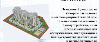
A land plot for individual use can be called a part of land that arises as a result of dividing a large plot into small ones with the boundaries recorded in the register (primary surveying, carried out by the municipality or the owner). It must be registered as property and registered in the cadastral register, assigned to a specific land user.
A site - especially if it is old, has existed for a long time and has even been inherited - during its operation it can change its boundaries: an unsuccessfully installed fence, earthworks, construction, etc. Boundaries can also be shifted intentionally.
Clarification of the boundaries of a land plot can initiate:
- owner;
- tenant under a long-term contract (more than 5 years);
- judge when resolving a dispute.
Typically this procedure is carried out in connection with:
- with purchase and sale or exchange transactions;
- with dividing the plot into smaller ones or allocating parts for the new owner;
- with the combination of the plot with the neighboring plot.
A separate point is the resolution of conflicts with neighbors. Typically, the question of legitimate land surveying arises if:
- a neighbor put up a permanent fence, occupying someone else's territory;
- he built a building that took over the area of the neighboring plot;
- the owner arbitrarily appropriated part of the common territory: he seized a section of the road, the adjacent territory, in a word, he prohibited access to public land.
If, when trying to point out the discrepancy between the actual boundaries and the legal ones, a neighbor provides a dubious boundary plan, it is worth trying to challenge it in court and restore the integrity of the boundaries of your property.
How to win a land survey trial
For a positive outcome of the case, you need to study reviews and find a lawyer with experience in resolving land disputes. Lawyers of the Pravozem Academy of Sciences win complex cases and know how to increase the chances of a positive outcome of the case. Check out our practice. We carry out the following events:
- We collect planning and cartographic information to justify the location of the site;
- We take measurements of the site and determine its exact boundaries;
- If errors or discrepancies are identified, we double-check the documentation for adjacent areas;
- We prepare an up-to-date boundary plan in a short time;
- We submit a request to appoint an examination and conduct it;
- We represent the interests of the client.
At the time of writing, we had 3 interesting situations in our work. We managed to correct the error by filing a lawsuit against the administration, and restored the boundaries of the client’s property when the neighbor refused. They proved that one plot was mistakenly assigned 2 numbers and the ownership was registered.
We prepare statements of claim, carry out land surveying, surveying and land surveying to resolve legal disputes. We formulate a boundary plan to eliminate errors. We restore lost boundaries and mark out areas if neighbors have interfered.
Which boundary plan is considered correct?
The procedure for carrying out and approving geodetic work is clearly specified in Federal Law-221 dated July 24, 2007 :
- work can only be performed by a licensed organization, as well as a specialist entered in the register of cadastral engineers;
- Land users of all neighboring (adjacent) plots are notified of the planned measurements. If their contacts are unknown, the owner must take care of finding them: obtain information from the cadastral chamber and send registered letters;
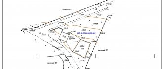
- measurements are carried out with a mandatory visit to the area, using special instruments. The length, width, angle of inclination, terrain, proximity of public facilities, reservoirs, and features of the surrounding surface are measured;
- based on the results, a site survey report, boundary or technical plan is drawn up;
- it must be signed by land users of adjacent plots;
- After signing, the plan is registered in the cadastral chamber.
Necessity
If land surveying has not been carried out before, the owner of the land plot will definitely order it if a controversial issue arises with a neighbor or there are attempts to illegally seize the plot. If the boundaries are clearly established, there will be strong arguments for protecting your rights; you can raise objections to the seizure of part of the site.
Specialists accurately establish the boundaries of the land of a particular plot and enter data into cadastral documents . And now the controversial issue with the owners of adjacent territories is resolved in a short time.
When can a plan be challenged?
The most common situations that cause a dispute:
- if the clarification or determination of boundaries took place without the participation of other interested parties other than the owner: for example, without neighbors. The document does not contain their signature indicating agreement with the results of the examination;
- violation during the initial survey: for example, if according to the documents the boundaries of the site are located in a completely different way than the actual ones. The site must be removed from the cadastral register, the initial survey must be carried out again, and only then transferred into ownership or long-term lease;
- the neighbor has arbitrarily occupied territory that is not his own and does not want to resolve the conflict pre-trial;
- a technical error was discovered when creating a boundary plan: an employee made incorrect measurements, entered data with errors, typos or inaccuracies, created an incomplete boundary plan, without mandatory parts (graphic and text), etc. In this case, you will have to force him to redo the work or return the money;
- the work was carried out by an organization deprived of a license or by an engineer not included in the register.
When do land survey disputes arise?
Of course, it is always easier to resolve any dispute peacefully, that is, to reach an agreement with your neighbors. But it is not always possible to find a common language. When considering conflicts of this kind, it is not oral statements that should be taken into account, but documentary evidence in the form of geodetic survey results. Moreover, each property, including a land plot, is subject to state registration, during which the coordinates of the boundaries must be established.
Land legislation determines the procedure in which a plot is formed, as well as its registration and registration of property rights:
- Land cannot acquire the status of an object of civil circulation without its state registration. The plot must be registered in the cadastral register.
- The delineation between adjacent plots occurs during the process of cadastral work, after which the land is registered in the cadastral register.
- The final stage is registration of ownership.
Each situation with disputed land surveying has its own nuances, but we can still name the most common causes of conflicts. Among them:
- Land surveying without the consent of all interested parties. It is impossible to resolve disputes of this kind without contacting Rosreestr.
- Violations during geodetic or cadastral work. The owner may disagree with the results and appeal them. If the appeal is successful, the disputed plot is removed from the registration register for land management work to be carried out again.
- The neighbors refuse to take part in resolving the dispute. In this case, the case, as a rule, is resolved only in court.
- The land plot was inherited by several owners who want to divide the land, but cannot come to an agreement. Partition in kind in such cases is carried out through the court.
- Technical errors when preparing documents. Documents are drawn up by people, and there is always a risk of careless mistakes.
- Errors in land surveying due to the fault of an incompetent specialist. In such cases, responsibility rests with the owner of the site.
- Self-capture. This fact is often revealed during land management work.
Participation of neighboring owners in the land surveying procedure
Only an examination with the results of which all interested parties agree can be recognized as legitimate and legal.
. To do this, an act of approval of boundaries must be attached to the boundary plan. It can be signed by:
- neighbor-owners;
- neighbors who are long-term tenants;
- legal representatives by power of attorney executed with the participation of a notary.
The notification procedure is prescribed in Article 39 of Federal Law-221. It is mandatory to notify neighbors in writing about planned geodetic work in the area. The minimum notice period is 7 days.
A meeting of owners and interested parties is held at the site on the day of the topographic survey. The work is carried out in the presence of meeting participants, after which the approval document is signed by the owners, neighbors, a representative of the local administration (for example, the board of SNT) and the engineer himself who carried out the work.
If you disagree with the work performed, objectors are required to:
- do not sign the act;
- Instead of a signature, attach a written statement of your claims to the survey.
All documentation is sent to Rosreestr, where objections and work performed are analyzed. Further, it is possible to challenge the boundary plan in court, or to declare the objections illegal.
Who carries out the work
Almost every site has adjacent boundaries with neighboring ones.
In recent years, the allocation of plots has been carried out with their land surveying; the owner must register his property with Rosreestr, and this is impossible without land surveying work. And only those owners who received plots decades ago sort things out among themselves before these disputes. How can you challenge your neighbor and protect yourself from land claims in the future? You need to call a cadastral engineer who has a license to perform the work.
Is it possible to demarcate the site yourself? Such activities are carried out only by licensed specialists; the result of their work has weight for the cadastral service and for Rosreestr.
ATTENTION! It is imperative to check the license of the engineer who will come to the site to determine its boundaries.
Such a responsible procedure as land surveying is not only carried out with permission, but its implementation is also controlled by the Committee on Land Management and Land Resources.
Procedure for challenging
All property disputes are resolved in two ways:
- in a pre-trial manner;
- through the court.
Who can challenge
This right is granted to all persons interested in drawing up a boundary plan:
- owner;
- to the tenant (for long-term lease);
- neighbors whose plots adjoin the boundaries defined by the boundary plan;
- heirs of the above categories.
If one of them has not received written notice of the upcoming land survey, he can safely demand a revision of the technical plan by filing a lawsuit.
Where to do it
To challenge the result of land surveying or clarifying the boundaries of a site, you need to go to court with a claim to declare the boundary plan illegal.
The content of the claim is standard:
- a header indicating the judicial authority and all participants in the process with personal and contact information: plaintiff, defendant, third parties;
- document's name;
- circumstances of the case: on what basis the plot belongs to the plaintiff, what relation the defendant and the third party have to the conflict, and what is the essence of the claim. The reasons why the boundary plan should be invalidated must be clearly stated;
- requirements for the claim: to recognize the boundary plan as illegal, to appoint a new procedure for determining boundaries, and others;
- date, signature;
- list of attachments (copies of all documents mentioned in the claim).
The claim is filed with the territorial court at the location of the disputed territory - the area where land surveying was carried out incorrectly.
Documentation
Copies must be attached to the statement of claim:
- controversial technical plan of the area;
- plaintiff's identification documents;
- evidence that the document does not correspond to reality: this may be another boundary plan, data from the cadastre and other papers;
- contracts, certificates, extracts, emails, archives, etc. related to the conflict;
- information from witnesses;
- confirmation of payment of the court fee.
- A fully completed statement of claim consists of a claim and annexes. The office is provided with the number of sets according to the number of participants in the process.
Cost of the procedure
Since challenging land surveying refers to non-property disputes, the state duty for individuals is 300 rubles . Additional expenses - expenses for examination, other costs - can be recovered from the defendant.
Causes of the conflict
- Problems with land surveying may arise due to a mistake by the specialist who established the boundaries of the land territory, or due to the desire of a neighbor to take part of someone else's land.
- Sometimes neighbors invite a land surveying specialist without notifying the owners of other nearby plots about the upcoming work. And in this case, he acts in his own interests.
- Perhaps the land owner has objections to the results of the work of a geodesy specialist; he believes that his interests have been violated. In this case, he can also appeal to the courts.
- Courts resolve controversial issues regarding land surveying in cases where people living nearby cannot agree with each other and do not trust each other. In this case, if there is no mutual understanding, it is better not to waste time and nerves; court employees will resolve the conflict competently, professionally, observing land legislation.
According to the court, it is possible to cancel the old land survey and order new work to establish the correct boundaries between the territories of neighboring areas.
The courts also consider claims concerning the boundaries of the land area of those who divide property after inheritance or after divorce, for example. Such conflicts are also complex, protracted, and it is almost impossible to resolve them independently. Especially if the parties to the conflict do not strive for a peaceful solution.
Neighbors' fences also cause heated debate; they can seize part of someone else's territory. It should be noted that a violation may occur unintentionally, for example, the boundaries were initially defined incorrectly.
ATTENTION! Judicial practice is also familiar with the consideration of the issue of the boundaries of a site that arose due to the seizure of territory. unauthorized seizure of land is already a violation of the law and entails punishment. Therefore, consideration will be carried out in several directions. And first the court must establish the real owner of the territory.
How does conflict resolution occur?
After setting the date of the meeting, agendas are sent to all participants: in the form of registered letters, telegrams or SMS notifications. At the first meeting, the plaintiff must bring the originals of all documents attached to the statement of claim.
The first meeting is usually introductory: the judge reads out the materials, gets acquainted with the positions of the parties, and attaches documents to the case. Defendants can present their accusations in the form of counterclaims, disagree with the plaintiff’s arguments and provide evidence of their case. On the same day, the judge determines the missing documents and orders an examination from the state geodetic organization.
Typically, in conflicts involving challenging a boundary plan, this procedure is mandatory. Therefore, lawyers recommend doing it in advance to save time and speed up getting a decision.
The outcome of all meetings depends on the arguments and persuasiveness of each party. The municipal cadastral engineer conducts his assessment (at the expense of the plaintiff or defendant), then the judge compares the result with the controversial boundary plan and makes a decision.
What it is
Land surveying legally establishes the boundaries that all plots of land must have. For a long time, land could be given out without title documents; neighboring plots were not divided along borders. As a result, such owners now cannot even prove their rights, nor can they prove the exact area of their property.
If no official land surveying work has been carried out, controversial issues regarding land plots are inevitable; many will want to add a few more centimeters and even meters to their plot. The lack of land surveying is therefore revealed most often when a conflict occurs between the owners of neighboring territories.
ATTENTION! When surveying land plots, boundaries are established officially and documented, and therefore all disputes between neighbors over additional area are resolved.
To order a land surveying procedure, you need to submit an application to the authority responsible for land registration and call the appropriate specialist.
Without neighbors present
By law, the owners of adjacent territories must be present during the work. But there may be situations when they do not want to come to the specified place or do not have the physical capabilities to do so (for example, they will be abroad for a long time). In such cases, land surveying can be carried out, but:
- You should definitely have proof that a written notice was sent to neighbors;
- you need to draw up a certificate of work performed and indicate that they were carried out strictly according to the law;
- the act of completed work is attached to the land surveying act.
✅ Who can apply?
Consent to boundary work is provided by persons who own/use the adjacent plot on the following grounds (documented):
- ownership;
- lease agreements;
- rights of perpetual use;
- rights of lifelong inheritable ownership.
Accordingly, if during the procedure the interests of these categories of citizens were violated, they have the right to challenge its results independently or through a legal representative (subject to the execution of a notarized power of attorney, which will indicate his right to perform such actions).
✅ Judicial practice
As judicial practice in cases of challenging land survey results shows, the court can take the side of both the injured land owner and the violating neighbor. Positive decisions are made only when a violation of the plaintiff’s rights in some form is actually revealed. If the neighbor carried out the procedure with violations, but the court determines, but the rights of the plaintiff were not violated, then the latter may not count on a court decision in his favor.
Example. Elena M. filed a lawsuit against Ivan P. carrying out land surveying in violation of the law and demanding that the results be cancelled. When considering the case materials, the court revealed a real violation of the procedure, but the result of the boundary work did not in any way affect the area and location of the boundaries of Elena M.’s land allotment, therefore the claim was denied.
Refusals to consider a case or satisfy claims also occur under the following circumstances:
- The claim is filed by a citizen who is not the owner or user of the land, and therefore cannot claim infringement of his rights.
- The plaintiff does not have evidence that gives grounds to challenge the procedure.
- During the process, it was established that the boundary plan reflected reliable information about the boundaries of the territories.
To cancel the survey results, the court needs compelling reasons. For example, claims regarding improperly established boundaries are permissible only in relation to those neighboring areas with which there are common contours.
Decisions in cases requiring the invalidation of boundary work are most often made in favor of the plaintiff in cases related to:
- failure to comply with the procedure for notifying neighbors about work;
- lack of signatures of interested parties in the Border Coordination Act;
- serious errors in the formation of the allotment and determining its area, as a result of which inaccurate information is indicated in the state register;
- the occurrence of obstacles for the plaintiff in the use of land;
- unauthorized occupation of land by a neighbor, which led to distortion of the boundaries of the plaintiff’s plot
- providing reliable information about errors in a previously drawn up boundary plan.
Example. Based on the evidence of Petrov P., the court was convinced that the owner of the neighboring plot, Sergeev S., carried out boundary work with violations. The presented materials confirmed the fact of a cadastral error in the form of an overlay of the boundaries of the defendant’s plot onto the territory of Petrov P. The court came to the conclusion that it was necessary to restore the rights of the plaintiff by declaring the results of survey work invalid and satisfying the claims of Petrov P.
Challenging the land survey and participating in the trial is a rather complicated procedure.
The main thing is to act legally competently and provide maximum evidence. Don't know what documents you can use to prove violation of your interests? The lawyers on our site will suggest ways to resolve a conflict situation, taking into account your individual circumstances. Thanks to a free consultation from experienced specialists, the likelihood of achieving a positive result increases significantly. Attention!
- Due to frequent changes in legislation, information sometimes becomes outdated faster than we can update it on the website.
- All cases are very individual and depend on many factors. Basic information does not guarantee a solution to your specific problems.
That's why FREE expert consultants work for you around the clock!
- via the form (below), or via online chat
- Call the hotline:
- 8(800)302-39-65
— All residents of the Russian Federation - +7(495)128-69-80
— Moscow and the Region - +7(812)509-13-65
— St. Petersburg and region
- FREE for a lawyer!
By submitting data you agree to the Consent to PD Processing, PD Processing Policy and User Agreement.
Anonymously
Information about you will not be disclosed
Fast
Fill out the form and a lawyer will contact you within 5 minutes
Tell your friends
Rate ( 1 ratings, average: 5.00 out of 5)
Author of the article
Maxim Privalov
Lawyer. 2 years of experience. I specialize in civil disputes in the field of housing and family law.
Author's rating
Articles written
614