Home / Real estate / Land / Land surveying / Land surveying for different types of purposes
Back
Published: 02/26/2017
Reading time: 14 min
0
1903
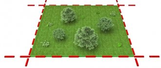
Land surveying refers to the process of determining the exact boundaries of a land plot and securing such boundaries in the boundary plan of a given plot.
The procedure for marking plots in a garden partnership is carried out according to certain rules by special organizations, and is necessary for legally full use of garden plots.
- The procedure for surveying a garden plot
- Where to begin
- Required documents
- Step-by-step instruction
- SNT territory survey project
- Possible problems during land surveying
The procedure for surveying a garden plot
Land surveying services are provided by geodetic companies that have the appropriate license.
The result of the work of such companies is a boundary plan of the site approved by the cadastral authority, the presence of which allows:
- Avoid disputes with the owners of neighboring plots regarding adjacent boundaries;
- Divide the land plot into several plots or combine it with other plots;
- Carry out the alienation of the plot in the future without legal problems.
It is important to draw up a survey plan in a timely manner due to the fact that the survey procedure in the future may become mandatory for owners, and then the workload of geodetic firms and the cost of such a procedure will increase.
Where to begin
Owners of garden plots who decide to carry out land surveying of their plots, first of all, need to collect all available information about the existing boundaries of such plots.
Such information may be contained in the following documents:
- In the cadastral passport allotment;
- In the scheme of the allotment from the board of SNT;
- In the SNT land surveying project;
- In technical terms of buildings.
In the absence of a boundary plan, the boundaries of the plot are still indicated in the cadastral passport, but this document provides only general information about the location of the plot.
It is important to remember that boundaries adjacent to neighboring areas must be agreed upon with the owners of such areas before land surveying.
Owners or tenants of neighboring plots must be notified of the upcoming land survey by convening a meeting by notification through notification letters or the media, in accordance with clause 8 of Art. 39 of Federal Law No. 221 “On Cadastral Activities” dated July 24, 2007.
At such a meeting, the survey organizer and users of neighboring areas must first agree on the location of adjacent boundaries.
After agreeing on the boundaries, you need to decide on a contractor company that will carry out land surveying. Such a company must have a special license to carry out geodetic and cartographic work, and the cadastral engineer directly performing measurements and calculations must be included in the unified register of cadastral engineers, which can be found on the Rosreestr website.
After this, you need to prepare documents for concluding an agreement with the contractor.
Required documents
To conclude a contract for land surveying work, the following documents will be required:
- Certificate of ownership (lease agreement) for the land plot;
- Title documents;
- Site diagram and technical plan;
- Cadastral passport;
- SNT territory survey project;
- Copy of the passport.
According to paragraph 3 of Art. 39 of the Federal Law “On Cadastral Activities”, land surveying can be carried out not only by the owners and tenants of this plot, but also by those using it by the right of free permanent use or lifelong inheritable possession.
Legal documents for a land plot include documents indicating the emergence of the right of ownership or use of such plot:
- Contract of sale;
- Lease contract;
- Agreement of exchange/donation;
- Agreement with the local administration on the provision of land for use;
- Certificate of receipt of inheritance.
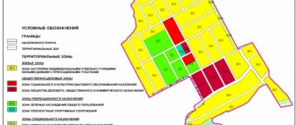
The project for surveying the territory of a gardening partnership is a diagram of the location of all plots of this partnership, indicating their boundaries.
More details about the land surveying project are provided in the section below.
The necessary extracts from the SNT land surveying project related to the plot to be surveyed, as well as a copy of the SNT land survey map with the location of the plots, can be obtained from the local administration where the garden partnership was registered.
What has changed regarding land surveying in 2021 with the adoption of the new law?
The law on horticulture introduced new concepts and reduced numerous dacha formations to two forms - a gardening non-profit partnership (SNT) and a garden non-profit partnership (ONT). If previously dacha plots had other names (dacha partnerships, dacha cooperatives and other associations of citizens), then according to the new law they must be renamed either SNT or ONT. The innovations didn't stop there. SNT and ONT have added requirements such as opening a bank account (we talked about the procedure for paying membership fees through a bank earlier), changes to the charter and defining the boundaries of the SNT territory. All this fell on the shoulders of the board in the person of the chairman and his assistants. If we talk specifically about the surveying of the common territory, the law requires that the boundaries of SNT and ONT be marked and defined; for this purpose, a general meeting is convened, a decision is made to carry out surveying of the common lands of the SNT, then a cadastral company is selected and a project for surveying the territory is prepared. (You can check prices for land surveying in your region and choose a suitable company using the online cadastral work calculator.)
Step-by-step instruction
The sequence of all actions to obtain a boundary plan for a land plot is generally as follows:
- Collection of necessary documents;
- Coordination of allotment boundaries with the owners of neighboring plots;
- Selecting a contractor company performing cadastral work;
- Agreeing with the selected company on the timing of the work and its cost;
- Signing a survey agreement with the contractor;
- Carrying out measuring and calculation work on the territory of the allotment by a cadastral engineer;
- Processing measurement results and drawing up a draft land survey plan;
- Coordination of the draft land survey plan with the customer and neighboring landowners;
- Coordination of the draft boundary plan with the SNT administration and the cadastral chamber;
- Registration and receipt by the customer of a boundary plan.
At the stage of signing the contract, it is important to agree not only on the general timing of the survey work, but also on the specific time of the cadastral engineer’s visit to the land plot to be surveyed.
During the work process, the cadastral engineer, using geodetic equipment, carries out the following activities on the site:
- Measurements of the lengths of actual borders;
- Photographing the territory;
- Measuring the level of the landscape within the garden plot;
- Inspection of soil and border objects;
- Installation of boundary marks (pegs).
To avoid trouble, the customer needs to notify neighbors about the date and time of the cadastral engineer’s visit, and also be present during the work in person.
The cadastral engineer performing the measuring work himself processes the results of his measurements and draws up a draft boundary plan, therefore it is necessary to coordinate with him all preliminary boundary points, involving the present neighbors in such coordination.
This will help to avoid unexpected claims after the completion of the work and approval of the boundary plan, and the procedure will have to be carried out again.
The resulting boundary plan must consist, in accordance with Part 5 of Art. 22 Federal Law No. 218 “On state registration of real estate”, in two parts:
- Graphic part;
- Text part.
The graphic part of the boundary plan is a map of the site with coordinates of boundary points and designations of access points to the site or passage through it (if a public easement is established).
The text part of the plan contains:
- General information about the plot of land, its area;
- Information on border coordination;
- Information about the cadastral engineer who carried out the work;
- Information about the existence of a dispute with neighboring land users.
The last point is indicated if it was not possible to reach a full agreement with neighbors regarding common boundaries.
General plan of SNT where to get it. Summary
- 1. Is it possible for SNT to exist on the territory of the city within the zone, which according to the general plan is defined as a Public and Business Zone and most of the plots in this territory have the status of individual housing construction?
1.1. It depends what you mean. Quite if, for example, the land for this SNT was allocated before a decision was made on the status of this zone.
2. When adjusting the General Plan of SNT, public lands were added to plot 40 a (without the knowledge of its owner) (passages to plots 38, 39, 40). As a result, the so-called "Easement". The new General Plan was signed by the chairman of the SNT (without discussion at the general meeting) and, according to her, has already been approved by the District Administration. How to fix these, in our opinion? Gross violations of the law? Best regards, Mikhail Petrovich
2.1. Hello! The administration should be concerned about this. In any case, the master plan of SNT, or rather the project for organizing the development of SNT, is approved by an administrative resolution, which can be appealed. Without documents, I cannot give detailed advice.
3. I want to receive from the architectural department the general plan of the building with changes and the documents on the basis of which it was changed. How to do it.
3.1. Submit an application to the architecture office for submission of information.
4. SNT general plan 1994, land surveying and registration of ownership 2009. There are 2 plots, located one behind the other from the road, numbers 1 and 2 according to the cadastre, but according to the general plan they are read as 2 and 1. 10 years have passed. Plots without buildings. Plot 1 is being sold, but then the owner of plot 2 wakes up and starts saying that this is a mistake and let’s exchange documents. What to do.
4.1. We need to see how it really is. And who has the documents for the property (Article 209 of the Civil Code of the Russian Federation). Go to court and resolve the issue there. Demand to appoint an examination (Article 79 of the Code of Civil Procedure of the Russian Federation). The expert will compare the documents. With what is in fact.
4.2. In this case, you need to contact a cadastral engineer to clarify the situation. If this is a cadastral error, it can be corrected. If not, there will be a dispute in court. And this will last for a long time. Land Code of the Russian Federation Article 64. Consideration of land disputes 1. Land disputes are considered in court. 2. Before the court accepts the case, the land dispute may be referred by the parties to an arbitration court for resolution. Federal Law of July 13, 2015 N 218-FZ “On State Registration of Real Estate” (as amended and supplemented, entered into force on January 1, 2019)3. An error reproduced in the Unified State Register of Real Estate, contained in a boundary plan, technical plan, map-plan of the territory or a survey report, arising as a result of an error made by the person who performed the cadastral work, or an error contained in documents sent or submitted to the rights registration authority by others persons and (or) bodies in the order of information interaction, as well as in another order established by this Federal Law (hereinafter referred to as a registry error), is subject to correction by decision of the state registrar of rights within five working days from the date of receipt of documents, including in the order information interaction, indicating the presence of registry errors and containing the information necessary to correct them, or on the basis of a court decision that has entered into legal force to correct the registry error. Correction of a registry error is carried out if such correction does not entail the termination, emergence, or transfer of the registered right to the property.
SNT territory survey project
A territory surveying project is a type of cadastral documentation of a territory,
which is compiled for plots of land to be divided into separate internal plots.
If the executive authorities provided a non-profit organization (garden partnership, partnership, etc.) with free use of land for the formation of summer cottages and garden plots, then this organization, in accordance with clause 4 of Art. 39.10 of the Land Code of the Russian Federation, is obliged to prepare a project for surveying the provided lands and organize work to create such a project.
The land surveying project of the gardening partnership is designed to coordinate the actions of developers of individual plots and construction activities carried out by the board of the partnership.
The SNT survey project consists of supporting materials and the main part, and the main part consists of a text block and survey drawings.
The survey drawings should show:
- Boundary lines (red lines) of the common territory of the gardening partnership;
- Points of acceptable proximity of internal buildings to the red lines;
- Coordinates of turning boundary points;
- The boundaries of the land plots being formed and their numbers;
- Boundaries of public easement zones (roads, driveways, etc.).
The red boundary lines are determined by the territory planning project approved by the local administration.
The text part, according to Part 4 of Art. 43 of the Town Planning Code of the Russian Federation, must include the following information about the plots to be created on the territory of the garden partnership, as well as the method of creating such plots and the types of permitted land use on the territory of this partnership, in accordance with the category of the land being described and the goals of the project (gardening) .
Drawing up a land surveying project includes the following main stages:
- Making a decision by the local administration on the allocation of land for SNT and the beginning of territory planning;
- Development of a land surveying project by a design organization;
- Coordination of the project with local executive authorities;
- Making a number of adjustments and approval by the administration of the SNT land surveying project.
The cost of creating a project depends on the area of the partnership being created, its features and the region of creation, mainly from 30,000 rubles.
It is important to remember that the formation of a specific plot of land for gardening from the lands of a gardening partnership is possible only if there is a land surveying project approved by the administration, in accordance with clause 3 of Art. 11.3 of the Land Code of the Russian Federation.
Every citizen of the Russian Federation can lease land for private plots from the state. Do you have a large family and want to buy an apartment with a mortgage? Find out what programs you can use. Read our article.
In some cases, you can pay off your mortgage using maternity capital. You can find out what documents you will need for this here.
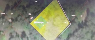
Where can I get a gardening partnership plan? Cadastral plan of SNT
Having a small garden or dacha plot, not every owner knows that his property must be registered with Rosreestr, and the SNT cadastral plan will help you correctly register your dacha and resolve many issues related to acquiring the right to a dacha plot. Today, the law on dacha amnesty, as well as a number of legislative acts, provide for mandatory registration of land and dacha plots. The law establishes preferential terms for registering property rights, but the general principle of acquiring rights is the same.
Please note that previously the SNT cadastral plan was a separate document, which was issued along with an extract from the Unified State Register, a cadastral passport and a state registration certificate. After the introduction of the new Federal Law-218, as well as changes to a number of legislative provisions for summer residents, previously issued forms are cancelled, and an extract from the Unified State Register becomes the new cadastral confirmation of your property.
Features of an extract from the Unified State Register of Real Estate and the cadastral plan of SNT
Having a cadastral plan of SNT by coordinate points, you can go through not only state registration, but also land surveying. In this case, cadastral work will firmly secure your ownership and outline the boundaries of the land plot in accordance with current legislation in this area. Summer residents can contact the SNT board to obtain the necessary information for state registration of both the land and the buildings located on it.
On our website you can order an online cadastral extract from the Unified State Register of Real Estate, where you can determine the status of your land plot at the moment. Below is an order scheme that will allow you to find out the necessary information online regarding the cadastral plan in SNT. An extract from the Unified State Register will indicate to you who is the owner of the property right, as well as the total area of the land plot, the date of acquisition of the right, cadastral value, facts of encumbrance and restrictions.
The extract has 4 sections, and sections No. 3 and No. 4 are completely devoted to a schematic representation of your site in SNT. Based on the existing cadastral plan of SNT, you can resolve any issues related to obtaining land rights, as well as donating, inheriting, etc.
How to correctly order a cadastral plan from SNT
On our website you will have access to an electronic or paper extract from the Unified State Register of Real Estate, including a simple form and with the seal of Rosreestr. A stamped plan is an official legal form that you can present to any authority to resolve land disputes. Please note that all working information about the arrest is contained in section No. 2, paragraph 4 of this extract. The cost of the service includes state duty.