The distance from the red line to the building line is documented and applied on the basis of current legislation (the so-called existing boundary) or a temporary, design distance according to SNiP (SP), valid until the moment of legal fixation. The norm for such a parameter is reflected in the Town Planning Code, SNiP (SP), and can be regulated by a master development plan adopted by local authorities for a specific locality - city, town, district. Conditional line is the boundary between private property and public territory, beyond which development of a private person’s land property cannot extend.
House
Red building lines: what are they?
The basic definition of the concept of red lines is given in Art. 1 of the Town Planning Code in force on the territory of the Russian Federation. The boundaries defined by this term are included, according to Chapter 5 of the same legislative document, in the package of documents for planning and obtaining a building permit.
Construction of an individual house
The owner of the plot must go through the stage of demarcation with other territories of any form of ownership with the help of cadastral authorities. Including private, public, areas for power lines or gas pipelines.
After this, the owner receives a diagram depicting a garden plot, an allotment for individual housing construction, and the adjacent territory on which a multi-storey residential building is located.
On the diagram issued as an appendix to the cadastral certificate, there is no indication of the CL. There are only dimensions and reference to specific landmarks.
Construction of a private residential building and territory development
The definition of a red line may vary somewhat depending on the location and purpose of the private land property intended for development:
- The Urban Planning Code refers to this term as a conventional boundary separating areas with public facilities accessible to all citizens from the land on which a private house is located. In this case, the distance from the red line to the building can be separately established by regulations of the local administration, SNiP or construction rules of the joint venture.
- According to the law on SNT, adopted in 2021, houses for permanent residence can be built on garden plots. The minimum size of land ownership is 6 acres. In such areas it is difficult to comply with the distances according to SNiP (SP), which regulate the construction of individual housing construction. Therefore, in gardening partnerships in 2021, the placement of buildings on the site may be regulated by the board of the partnership.
- In the Instructions on the Design Procedure adopted much earlier, back in 1998, the red line meant a conventional line that demarcates microdistricts and blocks from squares and streets.
- The demarcation on the general plan was marked in red, but since the adoption of the Urban Planning Code, the red line is understood not as the boundaries between blocks and streets, but as a conditional delimitation of territories for public use, plots of personal property and special ones allocated for the construction of communications.
Development of a plot at the dacha
At what distance from the red line a house can be built is determined not only by the distance from an already built object. For example, playgrounds, driveways, already constructed public or educational buildings.
What is a cadastral plan used for and how to get it
The third section of materials consists of a text description of boundary marks and information about adjacent territories. In the next paragraph of the CPT you can find out about the shares of the allotment. This section is present in the materials if the site is divided into parts. The fifth block is schematic data on the boundaries of the shares included in a single allotment. Like the previous point, this one is present if the plot is divided into shares.
The papers are handed over against the receipt of the receiving official. All materials are registered in a specially designated journal. When making changes to a document, confirmation of the new data must be provided. You have the right to a free adjustment of the scheme if you have independently identified in the document an area within the boundaries of the allotment that does not belong to you.
26 Jan 2021 etolaw 828
Share this post
- Related Posts
- I bought a apartment and sold it after 2 months. What tax will I pay?
- Steal Money From a Dead Man Esoterics
- Is it possible to pay a receipt for issuing a license through government services and come in person to the traffic police?
- Bailiffs Cannot Take A Car From a Disabled Person of Which Group
Boundaries of red building lines
The red development line is a conditional boundary that is established between public territory or important objects and the ongoing construction. It doesn’t matter whether we are talking about the construction of a private house, an apartment building, a multi-storey building for citizens to live in, or an office building.
Individual housing construction at the dacha
The criterion for setting the red boundary of a building is the red line of the street. The designation of the boundary on the approved project is also provided for reconstruction, restructuring, and addition to an existing facility.
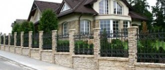
As in the case of the construction of individual housing construction, a fence is installed to ensure the safety of citizens and mark the red line of development, corresponding to the approved construction plan.
Standards for the location of buildings on sites in SNT and individual housing construction in accordance with SNiP (SP) and SanPiN
Both deployment along the KLZ and the indentation provided for by the project can be considered the norm. This is approved during construction approval, and violating already defined standards is unacceptable.
Possibility of line shift
It is possible that the owner of the plot, after purchasing it and the house, learned that the building violates the boundaries of the red building line. In such a situation, demolishing the house and answering for the previous owner’s violations is not economically justified. Then how to move the red line, and is it even possible to do it?
The transfer of red lines beyond the boundaries of a land plot is possible only by decision of local authorities.
This procedure is carried out taking into account the following legal features:
- The decision to move red lines is made by the municipality that initially decided on their current location;
- The transfer can be carried out if the current urban planning situation changes (buildings are reconstructed, street capacity is increased);
- The decision on illegally established line boundaries can be appealed in court or the prosecutor's office.
If the court recognizes the claim, the transfer of lines will be made after making changes to the relevant documents . Usually, to successfully resolve a dispute, citizens enlist the support of lawyers with extensive experience in this field of activity.
It is necessary to convince the administration or the court that the current boundaries are outdated and their location needs to be revised.
All regulations on the approval of the boundaries of red lines must be publicly published . If the publication of cartographic data does not take place, there is a chance to declare their location illegal and appeal the decision of local authorities.
The red line for territory development is the most important standard, mandatory for compliance by all citizens and legal entities. It separates private land ownership from public areas and communications.
Using the boundaries of the red line, standards for distances between neighboring houses and infrastructure facilities are determined, taking into account fire safety rules and convenience.
Failure to comply with the boundaries of the red lines entails bringing the guilty person to administrative responsibility.
Distance from building line to red line
SNiP regulates the placement of buildings and structures as a construction, which certainly takes into account the existing project and the red lines that are defined in a given locality.
Standards for building between individual wooden multi-storey buildings
It indicates how many meters must be so that a fire truck can pass. The existing network of engineering and technical communications and special facilities are also taken into account. Distancing from them is mandatory when building a residential building, and it is built with a mandatory indentation.
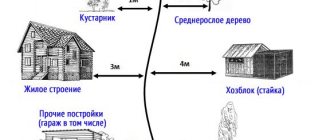
The residential building is set back from the red line of the road at least 5 meters, from the lane at least 3 m.
The same thing happens when an individual house is built. According to SNiP, it must be separated from the boundary of the neighboring plot and the red line of the street at the same three-meter distance. Failure to comply with established standards and arbitrary development of individual land property can easily result in litigation or demolition after its resolution.
Standards for placing a house relative to the road in SNT and individual housing construction according to SNiP (SP)
So, according to SNiP (SP) standards, a private house should be located no closer than 3 meters from the neighboring plot. Outbuildings – at a distance of 1 to 4 meters from the neighbors’ land plot. The setback for outbuildings should be 5 meters from the road, and 3 meters from the driveway or alley.
According to SP standards, the building line must be at a distance of at least 2 meters or more from any other red lines.
Application mechanism
Based on the Town Planning Code and various SNiPs (building codes and regulations), various kinds of standards have been established that determine the places where a residential building or various types of outbuildings can be built. That is, you cannot build on your site absolutely freely, in any place you like. What kind of requirements are we talking about here?
In the past, until 2015, there was a dacha amnesty, within the framework of which it was possible to first carry out development, and only then legalize it in local authorities. At the same time, those in charge were often lenient in situations where the rules associated with the use of the red line were violated. In recent years the situation has changed. If construction was first carried out, and then, in fact, they tried to legitimize it, then this may not work out except through going to court. However, a positive decision is by no means guaranteed. And an illegally erected building can be demolished, regardless of the fact that we are talking about one’s own plot of land.
What is the correct sequence of actions?
Necessary:
- Draw up all the necessary documents indicating the location where the residential building and outbuildings will be erected.
- Contact your local authorities and get permission from them.
- Carry out construction in full accordance with the executed documents.
The legal requirements are that the distances between the red line and the place where construction will take place are established.
In this case, it is also necessary to take into account fire safety standards, which relate to the distance between houses in neighboring areas.
Distance from the red line to a residential building
The distance from the house to the red line, according to SNiP standards, is reflected in several regulatory documents at once - the Town Planning and Land Codes, Resolutions of the State Construction Committee and Order of the Ministry of Regional Development No. 849. In 2021, additions to existing rules were adopted. They are associated with permission to build permanent residential buildings in SNT.
Layout of buildings on sites in SNT and individual housing construction in accordance with SanPiN and SNiP (SP) standards
Therefore, it is better to adhere to the existing requirements:
- in the private sector, to which the territory of SNT can now be conditionally included, a residential building cannot be located closer than three meters to the red building line;
- deviation from the rule is allowed only if the building has premises on the ground floor that are used as public premises, even if it is a converted apartment - such a building can be located on the edge of the cable line;
- in all other cases, the distance from the red line depends on the location of the house on the street.
Distance from neighbors' fence when developing a plot of land
If a violation of the distance norm is recorded not only for a house, but also for fencing a plot overlooking someone else’s territory, such a building will not be able to be privatized due to the existing discrepancy with the requirements of the Land Code. In the worst-case scenario, such a structure may be demolished.
How to use the public cadastral map
There are even more questions about the “lower” half of Shchelkovskoye Highway (cadastral block 5002, section 76). Plot 76 was registered on the same basis on January 29, 2008; the Federal Law “On the State Real Estate Cadastre” was also not yet in force. But the main question is that in several places the red line runs along the facades of houses. If these are residential houses, then this means that part of the land plot from the side of the highway was illegally cut off from them, without the knowledge of the owners and without compensation, and that when the highway was expanded, the road some may come close to houses. This disgrace is often found on other expanded highways.
We recommend reading: Sberbank leave a complaint online
On the same map there is also information that is also relevant for residents of Kaloshino - in connection with the expansion of Shchelkovskoye Highway. The thick red line in the middle of the highway is the border between cadastral blocks. The “upper” (on the map) half of the highway, adjacent to Kaloshino, is cadastral plot No. 29. It is separated from the microdistrict by a thin red line. This is the famous “red line” between a residential neighborhood and the highway. We dial :29 and read that the site was also previously registered, also registered on 01/01/2007.